TITLE 2 – PLANS
[Revised 1/21/2021]
2.A PLAN REQUIREMENTS
2.A.1 Public Hearing Process
The following Table lists the types of Plans that are required to be submitted for Zoning applications. Each request is identified with a number in each column corresponding to a note below for clarification. For finalizing the “Preliminary” plans that are approved by the BCC or ZC, the Applicant shall submit plans to the DRO following this Table, and label them as Final ____ Plans. e.g. Final Site Plan.
2.A.2 Administrative Process
For processes subject to approval by the DRO, the Applicant shall prepare and label all plans as Final Plans. e.g. Final Site Plan.
Table 2.A.1 - Required
Plans for BCC, ZC or DRO (Public Hearing/Administrative) Processes (1)
|
|
Rezoning or a
DOA to: |
Request or a
DOA for: |
Request for: |
||||||||||
|
Preliminary or
Final Plan |
M H P D |
M U P D |
M X P D |
P I P D |
P U D |
R V P D |
T D D |
Standard
District with a COZ |
Conditional
Uses |
Type 2
Variance |
Type 1 & 2 Waivers |
||
|
Master (PMP) |
(FMP) |
✔ 2 |
✔ 2 |
✔ 2 |
✔ 2 |
✔ 2 |
✔ 2 |
✔ 2 |
- |
- |
✔ 4 |
✔ 4 |
|
|
Site (PSP) |
(FSP) |
- |
✔ |
✔ |
- |
- |
- |
- |
✔ |
✔ |
✔ 4 |
✔ 4 |
|
|
Subdivision (PSBP) |
(FSBP) |
- |
✔ 3 |
✔ 3 |
✔ 3 |
- |
- |
- |
✔ 3 |
✔ 3 |
✔ 4 |
✔ 4 |
|
|
Regulating (PRP) |
(FRP) |
✔ 5 |
✔ 5 |
✔ 5 |
✔ 5 |
✔ 5 |
✔ 5 |
✔ 5 |
✔ 5 |
✔ 5 |
✔ 4, 5 |
✔ 4, 5 |
|
|
Master Sign (PMSP) |
(FMSP) |
✔ 6 |
✔ 6 |
✔ 6 |
✔ 6 |
✔ 6 |
✔ 6 |
✔ 6 |
✔ 6 |
✔ 6 |
✔ 4, 6 |
✔ 4, 6 |
|
|
Alternative Sign (PASP) |
(FASP) |
✔ 6 |
✔ 6 |
✔ 6 |
✔ 6 |
✔ 6 |
✔ 6 |
✔ 6 |
✔ 6 |
✔ 6 |
✔ 4, 6 |
✔ 4, 6 |
|
|
Landscape (PLP) |
(FLP) |
- |
- |
- |
- |
- |
- |
- |
- |
- |
✔ 4 |
✔ 4 |
|
|
Alternative Landscape (PALP) |
(FALP) |
- |
- |
- |
- |
- |
- |
- |
- |
- |
✔ 4 |
✔ 4 |
|
|
Arch. Elevations (PAE) |
(FAE) |
✔ 7 |
✔ 7 |
✔ 7 |
✔ 7 |
✔ 7 |
✔ 7 |
✔ 7 |
✔ 7 |
✔ 7 |
✔ 4, 7 |
✔ 4, 7 |
|
|
Floor (PFP) |
(FFP) |
✔ 7 |
✔ 7 |
✔ 7 |
✔ 7 |
✔ 7 |
✔ 7 |
✔ 7 |
✔ 7 |
✔ 7 |
✔ 4, 7 |
✔ 4, 7 |
|
|
Roof (PRFP) |
(FRFP) |
✔ 7 |
✔ 7 |
✔ 7 |
✔ 7 |
✔ 7 |
✔ 7 |
✔ 7 |
✔ 7 |
✔ 7 |
✔ 4, 7 |
✔ 4, 7 |
|
|
Notes: For those plans that are not listed in the
Table above, contact Zoning Division Staff for assistance. |
|||||||||||||
|
✔ |
Required Plan per Art. 2.A.6.B, Plan
Requirements. |
||||||||||||
|
1. |
Submitted as Preliminary Plans for Public Hearing
applications, and as Final Plans after BCC approval and submitted to the DRO for Final Approval. |
||||||||||||
|
2. |
Required for PDDs: PUD, RVPD, MHPD, PIPD, PDDs
with an MLU or EDC FLU designation or PUDs in the Lion Country Safari. BCC may approve a PMP for a MUPD or MXPD that
utilized more than one FLU designation in order to define location of uses
and property development regulations. |
||||||||||||
|
3. |
Subdivision
Plan shall replace Site Plan if a subdivision process is requested, unless
exempt pursuant to Art.11, Subdivision, Platting and Required Improvements. |
||||||||||||
|
4.
|
For Standalone or Concurrent Variance and Waiver
applications, the requests shall be identified and labelled on the applicable
Master, Site or Subdivision Plans. May
need to provide details to justify for the Variance or Waiver requests. |
||||||||||||
|
5. |
Optional. If
the Applicant chooses or recommended by staff to have design details,
cross-sections to be approved by BCC or ZC. |
||||||||||||
|
6. |
Shall be submitted at the time of the initial
application, and subject to the same review and approval process as the
development itself. See Art. 8, Signage. |
||||||||||||
|
7. |
Only required if the Applicant chooses or as
required by the ULDC to have Architectural Guidelines be approved by BCC or
ZC. See Art. 5.C, Design Guidelines. |
||||||||||||
2.B APPLICATION REQUIREMENTS – PLANS
Pursuant to Art.
2.A.6.B, Plan Requirements of the ULDC, the Applicant is required to submit one
or a combination of plans based on the request(s). All plans, whether they are submitted as
Preliminary or Final, shall be prepared in compliance with the ULDC and the
following additional requirements:
2.B.1 General Information and Drafting Standards
These standards are
established to provide information pertaining to the graphic and format
presentation of a plan. The following is
required for all types of plans, except stated otherwise. Deviations from these requirements may be
requested by contacting the DRO. The DRO
may consider whether the plan was done by a prior consultant; the legibility of
the text and graphic information; the request is limited to a small portion
(affected area) of the subject property, and will determine to what extent the
Applicant is required to update the plan for commencement of review. In addition, the Applicant may confer with the
DRO to consider waiving certain requirements.
Table 2.B.1 - Plan
Layout Requirements
|
2.B.1.B |
Plan
Size |
|
2.B.1.B.1 |
All plans and elevations shall be limited
to a plan size of 24” x 36”. |
|
2.B.1.B.2 |
Architectural Elevations – Must be submitted
in both color and black and white plans. |
|
2.B.1.C |
Electronic
Plan Format - All digital (CAD) plans shall be submitted as follows: |
|
2.B.1.C.1 |
Applications for the Public Hearing, Administrative
Review, and Type 1 Variance processes - in .DWF formats; |
|
2.B.1.C.2 |
All Plans shall be labeled consistent with
the Plan Requirements of Art. 2.A.6.B, Plan Requirements and the
Application Checklist and Naming Guide from the Zoning Website http://discover.pbcgov.org/pzb/zoning/Pages/Application-Processes.aspx |
|
2.B.1.D |
Scale |
|
|
All plans shall be drawn at an
Engineering scale ranging from 1” =
20’; 30’; 40’; 50’; 60’ or at a scale permitted by the DRO, with the
following exceptions: |
|
2.B.1.D.1 |
Master Plan or Overall Site Plan may be drawn at 1” = 100’, or at a
scale permitted by the DRO. |
|
2.B.1.D.2 |
Regulating and Master Sign Plans may be drawn at Architectural Scale. Scale for each detail may vary. |
|
2.B.1.D.3 |
Architectural Plans and elevations shall be drawn at an Architectural
scale of 3/32”, 3/16”, 1/8”, 1/4”, or 3/8” = 1’. |
|
2.B.1.E |
Plan Views |
|
|
All drawings,
except elevations and renderings, shall be prepared in two dimensional plan
views. |
|
2.B.1.F |
Font Style and Size |
|
|
Any legible font style. Zoning Division prefers Arial font style,
and font size shall be no less than 10 point. |
|
2.B.1.G |
Line Weight |
|
|
Line weight and
line type hierarchy on all plans shall be consistent with the American
National Standards Institute (ANSI) drafting standards. |
|
2.B.1.H |
|
|
2.B.1.H.1 |
Required for Architectural, Landscape, Lighting/Photometric Plans or
related submittal documents. For
Drainage, Traffic Statement or Study, and Survey/Plat, refer to Title 1 for
digital signature and seal. |
|
2.B.1.I |
Rounding
Decimals |
|
|
All numerical references shall be rounded
to a maximum of two decimal points. |
|
2.B.1.J |
Match
Lines |
|
|
Match lines shall
be clearly labeled to relate drawing segments (This requirement is not
applicable to Regulating Plan or Sign Plan). |
2.B.1.A Deviations
For those parcels of land that may not be
able to be shown on one plan without losing legibility because of the size or
configuration, the Applicant may show the entire parcel of land (the Site) on one plan, i.e. the Master
Plan with all the required information in accordance with the requirements of
this Title, e.g. Location Map, Site Data Table containing all the site’s
information, and match lines.
- The Site
shall be split with one or more match lines to be shown on separate Site
Plans at an appropriate scale as indicated in 2.B.1.D, Scale.
- The reference to
other Site Plans of each use shall also be labelled on the Master Plan,
e.g. see Site Plan (SP) 1 for the Type 1 Restaurant; and SP 2 for the Type
3 CLF, etc.
- Each use shall be
shown on a Site Plan where dimensions, labels and any other critical
information for that specific use(s)/structure(s)/site elements are
clearly shown.
- Each Plan shall be
labelled accordingly as MP, SP1, SP2, etc.
2.B.2 Title Block Information
The following information
shall be located on the right side (portrait orientation) or at the lower
portion (landscape orientation) of a plan.
Such information is required for ALL plans, unless otherwise stated
herein.
Table 2.B.2 - Title Block Information
|
2.B.2.A |
Consultants |
|
|
Consultant Logo Box (name, address, phone
number, fax, and e-mail, if applicable). |
|
2.B.2.B |
Control/Application
Name |
|
|
If the Application Name is different from the Control Name, the
Applicant shall list both names. |
|
2.B.2.C |
Type of Plan |
|
|
Label in accordance with Art. 2.A related to
Plan Requirements of the ULDC, and the Application Checklist and Naming
Guide on the Zoning Website. http://discover.pbcgov.org/pzb/zoning/Pages/Application-Processes.aspx |
|
2.B.2.D |
North Arrow |
|
|
Required for Master, Site, Subdivision, Landscape Plan(s) and Survey,
and may be noted on other types of Zoning Plans, where applicable. The North Arrow should be pointed to the
top. |
|
2.B.2.E |
Graphic Scale |
|
|
Prefer to be placed adjacent to the North Arrow or in a location of
the Plan where it is easily seen. |
|
2.B.2.F |
Revision Dates |
|
|
Each revision/resubmittal date must be identified in a chart. |
|
2.B.2.G |
Page Numbering |
|
|
If the submitted plans have more than one page, label with the acronym
consistent with Art. 1.H.3, Abbreviations and Acronyms of the ULDC, and the
page number. Example: PSP- Page 1 of
2. |
2.B.3 Other Required Plan Information
The following information
shall be provided on ALL plans unless otherwise indicated herein.
Table 2.B.3 - Other Required Plan Information
|
2.B.3.A |
Location Map |
|
|
A Location Map of the subject property (site) pertaining to the
application shall be prepared and shown on the applicable Plan (not required
on Regulating Plan), as follows: |
|
2.B.3.A.1 |
Minimum Map size – shall be placed in a 2.5” x 2.5” box; |
|
2.B.3.A.2 |
Site Location – shows the intersection of two nearest major streets
with street names identified; and, |
|
2.B.3.A.3 |
Street names – identify the
streets on which the site fronts. |
|
2.B.3.B |
Site Data Table |
|
|
See Title 2.B.4.A and 2.B.4.B of
this Chapter for information. |
|
2.B.3.C |
Legend |
|
|
If symbols and acronyms are used on the Plan. A chart must be prepared to identify all
symbols and acronyms and define what they represent. |
|
2.B.3.D |
|
|
|
A 4" x 4" box. The Zoning Stamp Box must be placed on
applicable Plans. |
|
2.B.3.E |
|
|
|
A 4" x 4" box, and should be
placed next to the Zoning Stamp box. The Amendment Stamp Box must be placed on
applicable Plans. |
2.B.4 Site Data Table
The Site Data Table
shall be provided on all Plans and shall include the following applicable
information, and in this order. For
Conceptual Plan, the Applicant may opt to provide all of the information as if
the application is prepared for the submittal of a Preliminary Plan:
Table 2.B.4.A - Required Site Data for Preliminary Plans (Public Hearing Processes) [1/2021]
|
|
Site Data |
PMP (Preliminary
Master Plan) |
PSP (Preliminary
Site Plan) |
PSBP (Preliminary Subdivision Plan) |
PRP (Preliminary
Regulating Plan) |
PMSP (Preliminary Master Sign Plan) |
PASP (Preliminary Alternative Sign Plan) |
PLP (preliminary
Landscape Plan) |
PALP (Preliminary Alternative Landscape Plan) |
PAE (Preliminary
Architectural Elevations) |
PFP (Preliminary
Floor Plan) |
PRFP (Preliminary Roof Plan) |
|
1 |
Application
Name (FKA names, if applicable) |
✔ |
✔ |
✔ |
✔ |
✔ |
✔ |
✔ |
✔ |
✔ |
✔ |
✔ |
|
2 |
Control
Number |
✔ |
✔ |
✔ |
✔ |
✔ |
✔ |
✔ |
✔ |
✔ |
✔ |
✔ |
|
3 |
Application
Number |
✔ |
✔ |
✔ |
✔ |
✔ |
✔ |
✔ |
✔ |
✔ |
✔ |
✔ |
|
4 |
Last
ZC/BCC Approval Date |
✔ |
✔ |
✔ |
|
|
|
|
|
|
|
|
|
5 |
Tier |
✔ |
✔ |
✔ |
- |
- |
- |
- |
- |
- |
- |
- |
|
6 |
Existing
Land Use Designation |
✔ |
✔ |
✔ |
- |
- |
- |
- |
- |
- |
- |
- |
|
7 |
Proposed
Land Use Designation |
✔ |
✔ |
✔ |
- |
- |
- |
- |
- |
- |
- |
- |
|
8 |
Existing
Zoning District |
✔ |
✔ |
✔ |
- |
- |
- |
- |
- |
- |
- |
- |
|
9 |
Proposed
Zoning District |
✔ |
✔ |
✔ |
- |
- |
- |
- |
- |
- |
- |
- |
|
10 |
Overlay(s) |
✔ |
✔ |
✔ |
- |
- |
- |
- |
- |
- |
- |
- |
|
11 |
Property
Control Number(s) |
✔ |
✔ |
✔ |
- |
- |
- |
- |
- |
- |
- |
- |
|
12 |
Existing
Uses |
✔ |
✔ |
✔ |
- |
- |
- |
- |
- |
- |
- |
- |
|
13 |
Proposed
Uses as contained in Art. 4 |
✔ |
✔ |
✔ |
- |
- |
- |
- |
- |
- |
- |
- |
|
14 |
Required/Proposed
Gross Site Area |
✔ |
✔ |
✔ |
- |
- |
- |
- |
- |
- |
- |
- |
|
15 |
Required/ Proposed Net
Site Area |
✔ |
✔ |
✔ |
- |
- |
- |
- |
- |
- |
- |
- |
|
16 |
Existing/Approved/Proposed
Density (Housing types and number of units) |
✔ |
✔ |
✔ |
- |
- |
- |
- |
- |
- |
- |
- |
|
17 |
Existing/Approved/Proposed
Density bonus program; (e.g. TDR, WHP, AHP) |
✔ |
✔ |
✔ |
- |
- |
- |
- |
- |
- |
- |
- |
|
18 |
Existing/Approved/Proposed
Intensity; (Gross Floor Area) |
✔ |
✔ |
✔ |
- |
- |
- |
- |
- |
- |
- |
- |
|
19 |
Required/Existing/Proposed
Parking |
✔ |
✔ |
✔ |
- |
- |
- |
- |
- |
- |
- |
- |
|
20 |
Required/Existing/Proposed
Accessible Parking |
✔ |
✔ |
✔ |
- |
- |
- |
- |
- |
- |
- |
- |
|
21 |
Required/Existing/Proposed
Loading |
✔ |
✔ |
✔ |
- |
- |
- |
- |
- |
- |
- |
- |
|
22 |
Required/Existing/Proposed
Building Height and number of stories (in feet) |
✔ |
✔ |
✔ |
- |
- |
- |
- |
- |
- |
- |
- |
|
23 |
Required/Existing/Proposed
Recreation |
✔ |
✔ |
✔ |
- |
- |
- |
- |
- |
- |
- |
- |
|
24 |
Required/Existing/Proposed
Civic |
✔ |
✔ |
✔ |
- |
- |
- |
- |
- |
- |
- |
- |
|
25 |
Traffic Analysis Zone
(TAZ) |
✔ |
✔ |
✔ |
- |
- |
- |
- |
- |
- |
- |
- |
|
Notes: |
||||||||||||
|
✔ |
Required Information |
|||||||||||
|
- |
Not applicable |
|||||||||||
Table 2.B.4.B - Required Site Data for Final Plans (Administrative Processes) [1/2021]
|
|
Site Data |
FMP (Final
Master Plan) |
FSP (Final
Site Plan) |
FSBP (Final Subdivision Plan) |
FRP (Final
Regulating Plan) |
FMSP (Final Master Sign Plan) |
FASP (Final Alternative Sign Plan) |
FLP (Final
Landscape Plan) |
FALP (Final Alternative Landscape Plan) |
FAE (Final Architectural
Elevations) |
FFP (Final
Floor Plan) |
FRFP (Final Roof Plan) |
|
|
1 |
Application
Name (FKA names, if applicable) |
✔ |
✔ |
✔ |
✔ |
✔ |
✔ |
✔ |
✔ |
✔ |
✔ |
✔ |
|
|
2 |
Control
Number |
✔ |
✔ |
✔ |
✔ |
✔ |
✔ |
✔ |
✔ |
✔ |
✔ |
✔ |
|
|
3 |
Application
Number |
✔ |
✔ |
✔ |
✔ |
✔ |
✔ |
✔ |
✔ |
✔ |
✔ |
✔ |
|
|
4 |
Last
ZC/BCC Approval Date |
✔ |
✔ |
✔ |
- |
- |
- |
- |
- |
- |
- |
- |
|
|
5 |
Tier |
✔ |
✔ |
✔ |
- |
- |
- |
- |
- |
- |
- |
- |
|
|
6 |
Land
Use Designation |
✔ |
✔ |
✔ |
- |
- |
- |
- |
- |
- |
- |
- |
|
|
7 |
Zoning
District |
✔ |
✔ |
✔ |
- |
- |
- |
- |
- |
- |
- |
- |
|
|
8 |
Overlay(s) |
✔ |
✔ |
✔ |
- |
- |
- |
- |
- |
- |
- |
- |
|
|
9 |
Property
Control Number(s) |
✔ |
✔ |
✔ |
- |
- |
- |
- |
- |
- |
- |
- |
|
|
10 |
Existing
Uses |
✔ |
✔ |
✔ |
- |
- |
- |
- |
- |
- |
- |
- |
|
|
11 |
Proposed
Uses |
✔ |
✔ |
✔ |
- |
- |
- |
- |
- |
- |
- |
- |
|
|
12 |
Required/Proposed
Gross Site Area |
✔ |
✔ |
✔ |
- |
- |
- |
- |
- |
- |
- |
- |
|
|
13 |
Required/ Proposed Net
Site Area |
✔ |
✔ |
✔ |
- |
- |
- |
- |
- |
- |
- |
- |
|
|
14 |
Existing/Approved/Proposed
Density (Housing types and number of units) |
✔ |
✔ |
✔ |
- |
- |
- |
- |
- |
- |
- |
- |
|
|
15 |
Existing/Approved/Proposed
Density bonus program; (e.g. TDR, WHP, AHP) |
✔ |
✔ |
✔ |
- |
- |
- |
- |
- |
- |
- |
- |
|
|
16 |
Existing/Approved/Proposed
Intensity; (Gross Floor Area) |
✔ |
✔ |
✔ |
- |
- |
- |
- |
- |
- |
- |
- |
|
|
17 |
Required/Existing/Proposed
Parking |
✔ |
✔ |
✔ |
- |
- |
- |
- |
- |
- |
- |
- |
|
|
18 |
Required/Existing/Proposed
Accessible Parking |
✔ |
✔ |
✔ |
- |
- |
- |
- |
- |
- |
- |
- |
|
|
19 |
Required/Existing/Proposed
Loading |
✔ |
✔ |
✔ |
- |
- |
- |
- |
- |
- |
- |
- |
|
|
20 |
Required/Existing/Proposed
Building Height and number of stories (in feet) |
✔ |
✔ |
✔ |
- |
- |
- |
- |
- |
- |
- |
- |
|
|
21 |
Required/Existing/Proposed
Recreation |
✔ |
✔ |
✔ |
- |
- |
- |
- |
- |
- |
- |
- |
|
|
22 |
Required/Existing/Proposed
Civic |
✔ |
✔ |
✔ |
- |
- |
- |
- |
- |
- |
- |
- |
|
|
23 |
Traffic Analysis Zone
(TAZ) |
✔ |
✔ |
✔ |
- |
- |
- |
- |
- |
- |
- |
- |
|
|
✔ |
|
Required Information |
|||||||||||
|
- |
|
Not applicable |
|||||||||||
2.B.5 Concurrency Table
The Applicant shall prepare a Concurrency Table indicating the concurrency for the proposed uses, and shall be consistent with what is represented on the graphic portion of the Plan.
Table 2.B.5 - Concurrency Reservation or Approved Concurrency (Examples)
|
Use (Pursuant
to Art. 4, Use Regulations) |
Intensity/Density
(square feet/seats/students/gas pumps, etc.) |
|
Congregate Living Facility |
No. of beds for Zoning No. of units for Engineering - Traffic |
|
Daycare |
square feet/no. of persons |
|
Gas and Fuel Sales, Retail (with Convenience Store) |
square feet/no. of fueling positions |
|
Medical Office |
square feet |
|
Retail Sales, General |
square feet |
|
School |
square feet/ no. of students |
|
Types 1 and 2 Restaurants |
square feet/no. of seats |
2.B.6 Site Elements and Graphic Data
Site elements are
specific to a subject property and application requests, and shall be shown
graphically on a Master, Site or Subdivision Plan, for either the Public
Hearing or Administrative Processes.
These graphics shall be supported by text, labeling, and dimensional
information (width, length, depth) for each of these site elements on the plan,
if applicable. Phase lines and affected
areas shall also be delineated and defined clearly on the Master, Site, or the
Subdivision plan(s). The Applicant may
choose to submit a Regulating Plan – Phasing of Development to demonstrate the
proposed phases.
2.B.6.A General Checklist for Plan Preparation
Other site
improvements or elements that are not included in this table may be required to
be shown by the DRO at the time of review of the application. Items included in this Checklist are organized
in an alphabetical order, and not in the order of drafting a plan.
2.B.7 Residential Elements
For residential
projects, the Applicant shall provide the following information.
Table 2.B.7 - Residential Elements
|
Site Elements |
Description |
|
Residential |
Density Bonus programs: WHP, AFH, TDR Housing types in each pod, number of units |
|
Overall density, acreage |
|
|
Net and gross density of each pod and acreage |
|
|
Pods/Parcels – residential, recreational, civic, and commercial, identify each pod or parcel with a number or a letter |
|
|
Gross density of adjacent residential properties |
2.B.8 Property Development Regulations (PDRs)
The Applicant shall
provide the following chart on the Master, Site or Subdivision plan, and add
rows/columns as necessary:
Table 2.B.8 - Property Development Regulations
|
Zoning
District or Pod |
Minimum
Lot Dimensions |
Density/GFA |
FAR |
Bldg.
Cover |
Setbacks/Separation |
|||||||
|
Size |
Width |
Frontage |
Depth |
Front |
Side |
Street |
Rear |
|||||
|
Required |
|
|
|
|
|
|
|
|
|
|
|
|
|
Proposed |
|
|
|
|
|
|
|
|
|
|
|
|
2.B.9 Planned Development Tabular Data
For Planned
Development District, the Applicant shall provide the following chart (Example)
on plan, and add rows/columns as necessary:
Table 2.B.9.A - Residential Planned Development Tabular Data (Example)
|
|
Last
BCC Approved |
Proposed |
|||||||||
|
|
Pod No. or (alpha) |
Pod Type |
Acre(s) |
No. of units in each Pod |
Net Density in each Pod Du/ac |
Pod No. or (alpha) |
Pod Type |
Acre(s) |
No. of units in each Pod |
Net Density in each Pod |
Housing Type/Unit/Net Density Change Between Approved and Proposed |
|
|
|
|
|
|
|
|
|
|
|
|
|
|
|
|
|
|
|
|
|
|
|
|
|
|
|
|
|
|
|
|
|
|
|
|
|
|
|
|
|
|
|
|
|
|
|
|
|
|
|
|
|
|
|
|
|
|
|
|
|
|
|
|
|
|
Total: |
- |
- |
# |
# |
- |
- |
- |
# |
# |
- |
# of units |
Table 2.B.9.B - Non-Residential Planned Development Tabular Data (Example)
|
|
Last
BCC Approved |
Proposed |
||||||||
|
|
Art. 4 Use Classification |
Approved Use |
Square footage |
Parking |
Art. 4 Use Classification |
Proposed Use |
Square Footage |
Parking |
||
|
|
|
|
|
Req’d |
Provided |
|
|
|
Req’d |
Prop |
|
|
|
|
|
|
|
|
|
|
|
|
|
|
|
|
|
|
|
|
|
|
|
|
|
|
|
|
|
|
|
|
|
|
|
|
|
|
|
|
|
|
|
|
|
|
|
|
|
|
|
|
|
|
|
|
|
|
|
|
|
Total: |
- |
- |
# |
# |
# |
- |
- |
# |
# |
# |
Note: Table 2.B.9.B may not be required to be submitted as part of the Administrative Modification or DOA application review, subject to the determination by the DRO.
2.B.10 Variances or Waivers
The Applicant shall
provide details of the proposed variance(s) or waiver(s) on the plan using the
following Chart. For applications that
have prior approved variances or waivers, the previously approved variances or
waivers that are not the same as the current proposed requests must also be
shown on the plan.
Table 2.B.10 - Variance or Waiver Chart
|
ULDC Code Reference Article/Section |
Required |
Provided |
Variance or Waiver |
Approval Date/Resolution No. |
|
|
|
|
|
|
|
|
|
|
|
|
|
|
|
|
|
|
2.C REGULATING PLAN
If the Applicant
chooses to submit Regulating Plans, the Plans shall be prepared following these
requirements. The Plan(s) may include
site elements that could be shown in graphic presentations, with construction
details, text, and dimensions to demonstrate the design and visual appearance
of each of these elements. At review
time, Staff will determine which details are required to be shown on the
Regulating Plan, or on other types of plans, or could be submitted in
manufacturers’ cut sheets.
2.C.1 Residential
The following
information may be shown on a Regulating Plan if the Site or Subdivision Plan
does not have sufficient area to show the details:
Table 2.C.1 - Residential Housing Types
|
(Fee Simple
Ownership) |
(Fee Simple
Ownership) |
(Condominium
Ownership) |
|
Dimension
and label Zero Lot Line side |
Dimension and
label Lot lines |
|
|
Dimension and
label overhang easements |
Dimension and
label parking and garage (Garage allowed when on dedicated R-O-W; garage with
back out onto parking tract not permitted) |
|
|
Dimension minimum
length of home along Zero
Lot Line sides |
Label parking and
provide breakdown by number of units/bedrooms (can be shown in Site Data) |
|
|
Dimension and
label side street homes (a.k.a. floaters) |
Dimension, label and provide numbers of guest parking; covered
parking areas |
|
2.C.2 Phasing
Phasing may be
shown on a Regulating Plan, and shall be labeled as “Regulating Plan –
Development Phasing”. A Phasing Table
shall be included on the Plan to clearly define the following:
A. Number
of Phases for the overall development;
B. Phasing Timeline – Commencement of each phase. If an “interim” use is being approved by the
BCC or ZC, the date of the discontinuance of the interim use must be shown;
C. Proposed Uses for each phase;
D. No. of buildings and square footage affiliated with each use;
E. Acres and Percentages – breakdown of percentage of land area associated
with each phase. It must comply with the
minimum percentage of the land area for each phase of the development as
referenced in Art. 2.E, Monitoring.
Table 2.C.2 - Development Phasing Table
|
Phase |
Phasing Timeline |
Proposed Uses |
No. of buildings
and S.F. or Units |
Acres &
Percentages of Land Area for each Phase |
|
# |
Date |
|
|
|
|
|
|
|
|
|
|
|
|
|
|
|
|
|
|
|
|
|
|
|
|
|
|
|
2.D TEMPORARY USE
The Applicant shall
use the most recently approved Plan, if applicable, as part of the Application
requirements. If no site plan is available, an as-built survey must be provided
to show the location and use approval.
2.E DIGITAL PLAN FORMAT (AKA EPLANS)
For online submission of applications through the County’s ePZB website, all digital plans and documents shall be submitted in the format identified in the “Zoning Applications Checklist and Naming Guide”.
http://discover.pbcgov.org/pzb/zoning/Pages/Applications-Forms.aspx
2.F COTTAGE HOMES
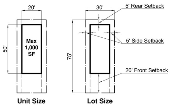
The following graphics clarify the two types of Cottage homes, an individual detached unit on an individual lot as shown in Figure 2.F.1, and multiple detached units on a single lot as shown on Figure 2.F.2.
Figure 2.F.1 Cottage Home – Single unit on a Single lot
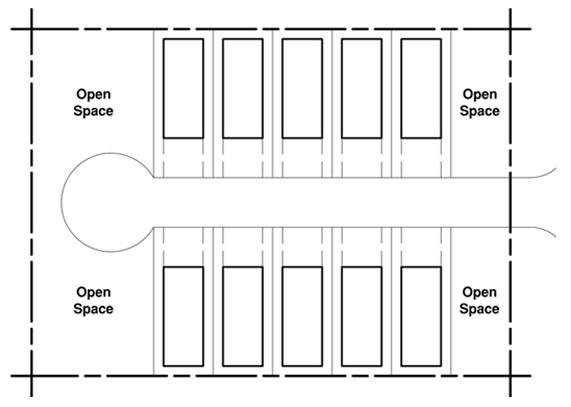
Figure 2.F.2 - Cottage Home – Multiple Units on a Single Lot
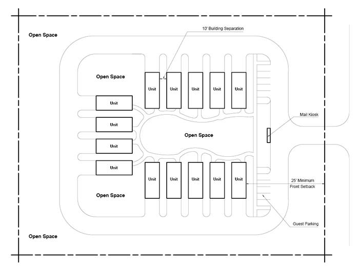
Figure 2.F.3 - Cottage Home Dimensions