Search Entire Article Tip -Hold CTRL + F
Article 1
GENERAL PROVISIONS
This Code shall be
known as the “Palm Beach County Unified Land Development Code” and may be
referred to herein as the “Code.”
Any reference to this
Code, a statute, ordinance, a resolution, or common law cited herein shall
include any amendment thereto.
The Board of County Commissioners
(BCC) has the authority to adopt this Code pursuant to Art. VIII, § 1(g), Fla. Const., the PBC Charter, F.S. § 125.01, F.S. § 163.3161, and such other authority and provisions
that are established by statute, administrative rule, or common law in the
State of Florida. [Ord. 2019-005]
It is the intent of the
BCC that this Code implement and ensure that all Development Orders approved in
unincorporated Palm Beach County (PBC) are consistent with the Comprehensive
Plan and its managed growth systems.
It is the intent of the
BCC that this Code establish comprehensive and consistent standards and
procedures for the review and approval of all proposed development of land in
unincorporated PBC.
It is the further
purpose of the BCC that the development review, approval, and permitting
process established by this Code be efficient, in terms of time and expense;
effective, in terms of addressing the natural resource and public facility
implications of proposed development; and, equitable, in terms of consistency
with established regulations and procedures, respect for the rights of Property
Owners, and consideration of the interests of the citizens of PBC.
This Code is adopted to
encourage the most appropriate use of land, water, and natural resources;
prevent the overcrowding of land and avoid undue concentration of population;
facilitate the adequate and efficient provision of transportation, water,
sewage, drainage, solid waste, parks, schools, fire, and police facilities;
conserve, develop, utilize, and protect natural resources; protect human,
environmental, social, and economic resources; and, maintain, through orderly
growth and development, the community character and stability of present and
future land uses and development in PBC.
No Building Permit
shall be issued for any structure on any lot created by a subdivision of land
until such lot is shown on a plat of record or certified survey recorded in the
manner prescribed in this Article, except as provided below.
a. Exceptions
Temporary structures,
permanent structures having a Temporary Use, and ancillary structures such as
fences, buffer walls, and guardhouses may receive a Building Permit prior to
recordation of the Final Plat for the property only when the use and location
have been approved by the DRO and shown on the approved Final Subdivision Plan.
Such approval, however, shall not in any way relieve the Property Owner from
the obligation to correct any and all non-conforming setbacks, separations, or
encroachments due to inconsistencies between the location of said structures
and lot, street, or easement boundaries as established by the applicable record
plat.
b. Revocation
PZB may revoke a
Building Permit or CO in those cases where an administrative determination has
been duly made in which false statements or misrepresentations resulted as to
material fact(s) in the application or plans upon which the permit or approval
was based.
c. Suspension
PZB may suspend a Building
Permit or CO or use where an administrative determination has been duly made in
which an error or omission on either the part of the permit Applicant or
government agency resulted in the issuance of the permit or certificate
approval. A valid permit or certificate shall be issued in place of the
incorrect permit or certificate after correction of the error or omission.
The provisions of
this Code shall apply to the development of all land in unincorporated PBC,
unless stated otherwise. No development shall be undertaken unless authorized
by a Development Order. [Ord. 2010-022]
See Art. 1.H, Definitions and Acronyms.
Interpretations to this
Code and the Official Zoning Map shall be made by the Executive Director of PZB
or designee with the following exceptions: [Ord. 2011-016]
1. The Director of Parks and Recreation shall
have the authority to interpret Art. 5.D, Parks and Recreation – Rules and
Recreation Standards; [Ord. 2011-016]
2. The Executive Director of Palm Tran shall
have the authority to make interpretations of Art. 5.H, Mass Transit Standards; [Ord. 2011-016]
3. The County Engineer shall have the authority
to make all interpretations of Art. 4.B.10.B.7.a.10), Hauling Standards; Art. 4.B.10.B.7.b.2)c), Drainage; Art. 4.B.10.C.5.g.5), Haul Agreement; Art. 6.B.3.A.2.a.3), Driveways and Access; Art. 11, Subdivision, Platting, and Required
Improvements; and, Art. 12, Traffic Performance Standards; [Ord. 2011-016] [Ord. 2017-007]
4. The Impact Fee Manager shall have the
authority to make all interpretations of Art. 13, Impact Fees;
[Ord. 2011-016] [Ord. 2022-026]
5. The Director of ERM shall have the authority
to make all interpretations of Art. 14, Environmental Standards and to interpret the following parts of Art. 4.B.10, Excavation Uses in consultation with the Executive Director
of PZB or designee as appropriate: Art. 4.B.10.B.4.b.8), WCAA Canals; Art. 4.B.10.B.4.b.9), Mitigation Projects; Art. 4.B.10.B.4.b.10), Wetlands; Art. 4.B.10.B.4.b.13), Canals of Conveyance; Art. 4.B.10.B.7.c.1)a)(2), Littoral Planting; Art. 4.B.10.B.7.c.3), Littoral Planting
Reclamation Standards; Art. 4.B.10.B.7.c.5), Area of Record; Art. 4.B.10.B.7.d.5)b), Excavated Area; Art. 4.B.10.B.7.d.5)c), Littoral Zones; Art. 4.B.10.B.7.d.6)b), Excavated Area and
Litoral Zones; Art. 4.B.10.B.7.d.7)a), Excavated Areas for
Type 3 Excavation; Art. 4.B.10.B.7.e, Maintenance and Monitoring; Art. 4.B.10.B.8.a, Administrative Waiver
from Construction Criteria for Agricultural, WCAA, Type 2, and Type 3 Excavations; Art. 4.B.10.B.8.b.1), Violations; Art. 4.B.10.B.8.f, Use of Collected Monies; Art. 4.B.10.C.1.h, Art.
4.B.10.C.1.i.6), and Art.
4.B.10.C.5.g.6), Notice of Intent to
Construct; Art.
4.B.10.C.1.c, Maximum Depth; Art. 4.B.10.C.4.e,; and, Art. 4.B.10.C.5.e, Depth; [Ord.
2011-016] [Ord. 2017-007]
6. The County Health Department Director shall
have the authority to make all interpretations of Art. 15, Health Regulations; [Ord. 2011-016]
7. The PBC Airport Director shall have the
authority to interpret Art. 16, Airport Regulations; [Ord. 2011-016]
8. The Flood Damage Prevention Administrator
shall have the authority to interpret Art. 18, Flood Damage Prevention; [Ord. 2011-016]
9. The County Administrator or designee shall
have the authority to interpret Art. 5.I, Murals;
and, [Ord. 2013-021]
10. The Executive Director of PZB or designee
shall have the authority to make interpretations of the following provisions
found in Art. 4.B.10, Excavation Uses in consultation with the Director of ERM
and the County Engineer as appropriate: Art. 4.B.10.B.4.a, Prohibitions; Art. 4.B.10.B.4.b.12), De
Minimis Impact; Art. 4.B.10.B.4.b.14), Excavation by Public Agencies; Art. 4.B.10.B.6.e, Written Approval; Art. 4.B.10.B.7.b.2), Slopes
except for Art.
4.B.10.B.7.b.2)c), Drainage; Art. 4.B.10.B.7.d.1), General; Art. 4.B.10.B.7.d.2), Guarantees Required; Art. 4.B.10.B.7.d.4), Form of Guarantee; Art. 4.B.10.B.7.d.6), Submittal and Approval of Guarantee; Art. 4.B.10.B.7.d.7), Duration and Release; Art. 4.B.10.B.7.d.8), PBC Use of Guarantee; and, Art. 4.B.10.B.8.c, Enforcement. [Ord.
2017-007]
An appeal to contest an
interpretation of this Code may be filed pursuant to Art. 2.A.14, Appeal.
[Ord. 2011-016]
Except as
specifically set forth in Art. 1.B.1, Interpretations, any assistance given or representation made by a PBC employee during
consultation shall not constitute the approval of the Department, shall not
bind the Staff, the Department, the Division, the Executive Director, or the
BCC, and shall not relieve any person of any requirements of this Code or other
applicable provisions of Federal, State law, or Local ordinances. If there
exists a conflict between any Staff representation and the laws, rules, codes,
or ordinances, such laws, rules, codes, or ordinances shall prevail to the
extent allowed by law.
The rules set out
in this Section shall be used to enforce and apply this Code, unless such rules
are inconsistent with the Plan. References to Florida Statutes (F.S.) and the
Florida Administrative Code (F.A.C.) refer to citations published in 2003 as
may be amended.
The rules and
definitions set out in this Section shall not be applied to any express
provision, which are specifically excluded. This Code shall be liberally
construed in order that the intent of the Plan may be fully carried out. In
cases of conflict, the Plan shall prevail to the extent of the conflict. Terms
used in this Code, unless otherwise stated, shall have the meanings prescribed
by the Statutes of the State of Florida for the same terms.
The interpretation and
application of any provision in this Code shall be the minimum required to
promote the public health, safety, comfort, convenience, and general welfare.
Where interpretation and application of any provision in this Code imposes
greater restrictions upon the subject matter than a general provision imposed
by the Plan or other provision in this Code, the provision imposing the greater
restriction shall control.
a. Affected Area – Use of the term “affected area” shall refer to that portion of a
project which is the subject of a Development Permit, Development Order, or a
modification, including all aspects and peripheral areas.
b. And – All cases apply.
c. Building or Structure – Use of terms “building” or “structure”
shall refer to the classification of the subject building or structure in the
Florida Building Code.
d. Common Words and Punctuation – Common words, phrases, and
punctuation shall be construed and understood according to the common and approved
use of the English language. Common words shall have the meaning assigned to
them in the latest edition of an English dictionary unless otherwise defined in
this Code.
e. Computation of Time – The time within which an act is to
be completed shall be computed by excluding the first day and including the
last day; if the last day is a Saturday, Sunday, or legal holiday recognized by
PBC, that day shall also be excluded.
f. Day – A working weekday unless otherwise stated or used in reference
to a violation. Violations shall be calculated on calendar days.
g. Delegation of Authority – If the head of a Department,
Division, or other PBC Official or employee is required to do some act or
perform some duty, it shall be construed to authorize the head of the Department,
Division, or other official or employee to designate, delegate, and authorize
professional-level subordinates to perform the required act or duty on their
behalf, unless the terms of the provision or Section specify otherwise.
h. Gender – Words implying the masculine gender shall be construed to
include the feminine and neuter genders.
i. Headings – Headings of Articles, Chapters, Sections, and Subsections shall
not be construed as the sole meaning or intent of the underlying regulation or
standards.
j. Include/Such As – Use of the word “include,” “includes,” or “including” or terms “such
as” shall not limit a term to the specified examples, but shall extend its
meaning to all other instances or circumstances of like kind or character.
k. May – Permissive.
l. Month – A calendar month.
m. Must – Mandatory.
n. Number – A word importing the singular number only may extend and be
applied to several persons or things as well as to one person or thing. The use
of a plural number shall be deemed to include any single person or thing.
o. Or
– Either or both cases apply.
p. Prohibited
– Shall mean not allowed and precludes Variance relief. [Ord. 2010-022] [Ord. 2014-001]
q. Project – Use of the term “project” shall refer to the entire development
referenced or implied in the regulation, standard, or definition.
r. References – Reference to the F.S., the F.A.C., and the
Code of Federal Regulations refer to citations published in 2003 as may be
amended.
s. Rounding
of Fractions – Rounding
may be permitted for itemized requirements such as minimum parking spaces,
trees, shrubs, or other similar required by this Code, as well as linear or
area dimensions, except that PDRs for minimum lot dimensions may only be
rounded for Legal Lots of Record, and rounding shall not apply to density. Rounding
shall not be permitted for any build-to-lines, maximum height limitations, or
any measurement used to calculate a number. The results of calculations
containing a fraction of one-half or greater, shall be rounded up to the
nearest whole number; and a fraction of less than one-half shall be rounded
down to the nearest whole number. [Ord.
2017-025]
t. Shall – Mandatory.
u. Technical Words and Undefined Terms – Technical words and undefined terms,
phrases, terms of art, vernacular, and the use of words which have acquired a
peculiar and appropriate meaning and which are not defined in this Code shall
be construed and understood according to such meaning.
v. Tense – Words used in the past or present tense shall also include the
future tense and conversely.
w. Terms Found in the Plan – Terms not found in this Code, but
found in the Plan, shall have the meaning given in the Plan.
x. Text – In case of any difference of meaning between the text of this
Code and any Figure, graphic, or Table, the text shall control.
y. Week – Seven-calendar days.
z. Weekend – Friday, Saturday, and
Sunday. [Ord. 2012-027]
aa. Written – Any representation of words, letters, or
figures whether by printing or other form of writing.
bb. Year – A calendar year, unless otherwise
indicated.
In case of
uncertainty, the PZB Executive Director shall interpret the intent of the
Official Zoning Map to determine the location of boundaries. Where uncertainty
exists concerning the boundary of a district on the Official Zoning Map, the
following rules shall apply. [Ord.
2011-016]
Where boundaries
approximately bisect blocks, the boundaries shall be the median line of such
blocks, or the centerline of the street that forms a boundary.
Boundaries indicated as
approximately following the centerlines of streets, alleys, or highways shall
be construed as following such centerlines.
Where parcels of land
or water areas have been inadvertently excluded from a district, said parcels
shall be given an Agricultural Residential (AR) classification.
Boundaries indicated as
approximately following platted lot lines, section, or tract lines shall be
construed as following such lines.
Where boundaries are
approximately parallel to a street, highway, alley, or railroad R-O-W, the
distance of such boundaries from the property line of such shall be, one
existing lot depth unless otherwise shown by dimensions on the Official Zoning
Map.
The distance of such
boundaries from the property line to the nearest lot line shall be between lots
to conform to adjacent district lines or approximately 150 feet.
Boundaries indicated as
approximately following political boundaries shall be construed as following
such political boundaries.
Boundaries indicated as
following railroad lines shall be construed as following the centerline of the
railroad R-O-W.
Boundaries indicated as
approximately following shorelines shall be construed as following such
shorelines. In the event of a change in the shoreline, boundaries shall be
construed as moving with the actual shoreline. Boundaries indicated as approximately
following the centerlines of streams, rivers, canals, lakes, or other bodies of
water shall be construed to follow such centerlines.
A lot in its
existing configuration as of the effective date of this Code, located in two or
more zoning districts not as a result of actions by the Property Owner, shall
apply the following:
If more than 50 percent
of the lot area is located in one district, the use regulations applicable to
the district containing the majority lot area shall apply to the entire lot, if
consistent with the Plan.
If more than 50 percent
of the gross lot area is located in one district, the PDRs applicable to the
district containing the majority lot area shall apply to the entire lot.
Distance
requirements between a proposed use and another use shall require the spatial
separation to be measured between the proposed and the other use within
unincorporated PBC and, if applicable, other jurisdictions, including
municipalities and other counties. If a conflict exists between this Section
and another Section, the definition in Art. 1.H, Definitions and Acronyms, shall apply.
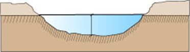
From the lowest point
of an excavated area to the ordinary high-water mark.
|
Figure
1.C.4.A – Typical Example to Measure Depth
|
|
|
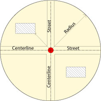
By drawing a straight
line from a site element, use, or structure to:
1. The intersection of two centerlines;
2. Another site element, such as parking; or,
3. A specific distance, such as 1,320 feet.
|
Figure
1.C.4.B – Typical Example of Measurement of Distance from Centerline to Site
Element
|
|
|
|
[Ord. 2005-002]
|
|
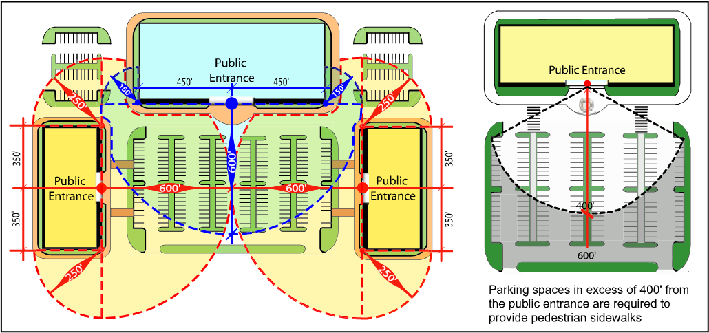
Figure
1.C.4.B – Typical Example of Measurement of Distance to a Specific Site
Element (Parking Space)
|
|
|
|
[Ord. 2005-002]
|
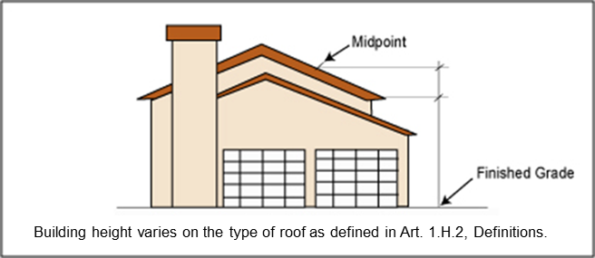
From finished grade to
highest point or peak of roof.
Refer to definitions of
building height in Art. 1.H, Definitions and Acronyms.
|
Figure
1.C.4.C – Typical Example of Measurement of Building Height
|
|
|
|
[Ord. 2005-002]
|
Refer to Art. 5.B.1.A.2.a, Height Measurement.
Refer to Art. 7.D.4.A, Hedges.
|
Figure
1.C.4.C – Typical Example of Measurement of Hedge Height
|
|

|
|
The height of a hedge shall be measured in
accordance with Art.
7.D.4.A, Hedges.
|
Refer to Art. 7.D.6.C, Height Measurement, and Figure 7.D.6, Berm Elevation and Drainage
Requirements. [Ord.
2005-002]
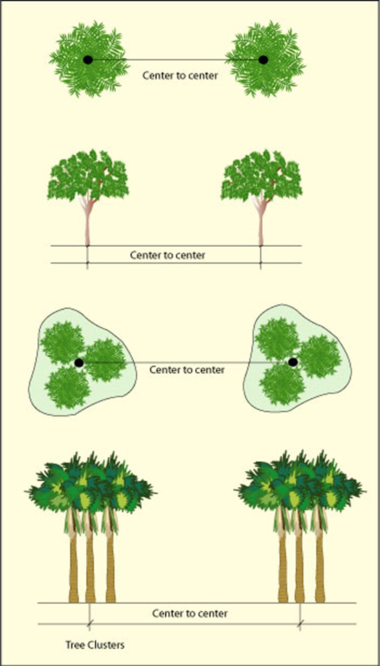
By drawing a straight
line between.
1. Individual trees or shrubs (centerline to
centerline); or
2. Tree clusters, or shrub clusters (centerline
to centerline).
|
Figure
1.C.4.D – Typical Example of Measurement from Centerline
|
|
|
By drawing a straight
line from the closest point on the perimeter of the exterior wall, structure,
or bay to another structure, the property line, or a well or septic.
By drawing a straight
line from the closest point on the perimeter of the exterior wall, structure,
or bay to the base building line, the R-O-W line, the edge of the water, or the
property line.
|
Figure
1.C.4.F – Typical Example of Measurement
of Separation
from a Property Line
|
|
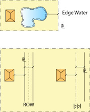
|
G. Separation from a Zoning District or FLU Designation
When adjacent parcels, located in different zoning districts or
FLU designations, and are separated by a R-O-W, the required separation
distance shall be measured by drawing a straight line from the closest point of
the applicable structure to the closest point of the adjacent property line
across the R-O-W. [Ord. 2018-002]
|
Figure 1.C.4.G – Typical Example of Separation from a
Zoning District or FLU Designation
|
|
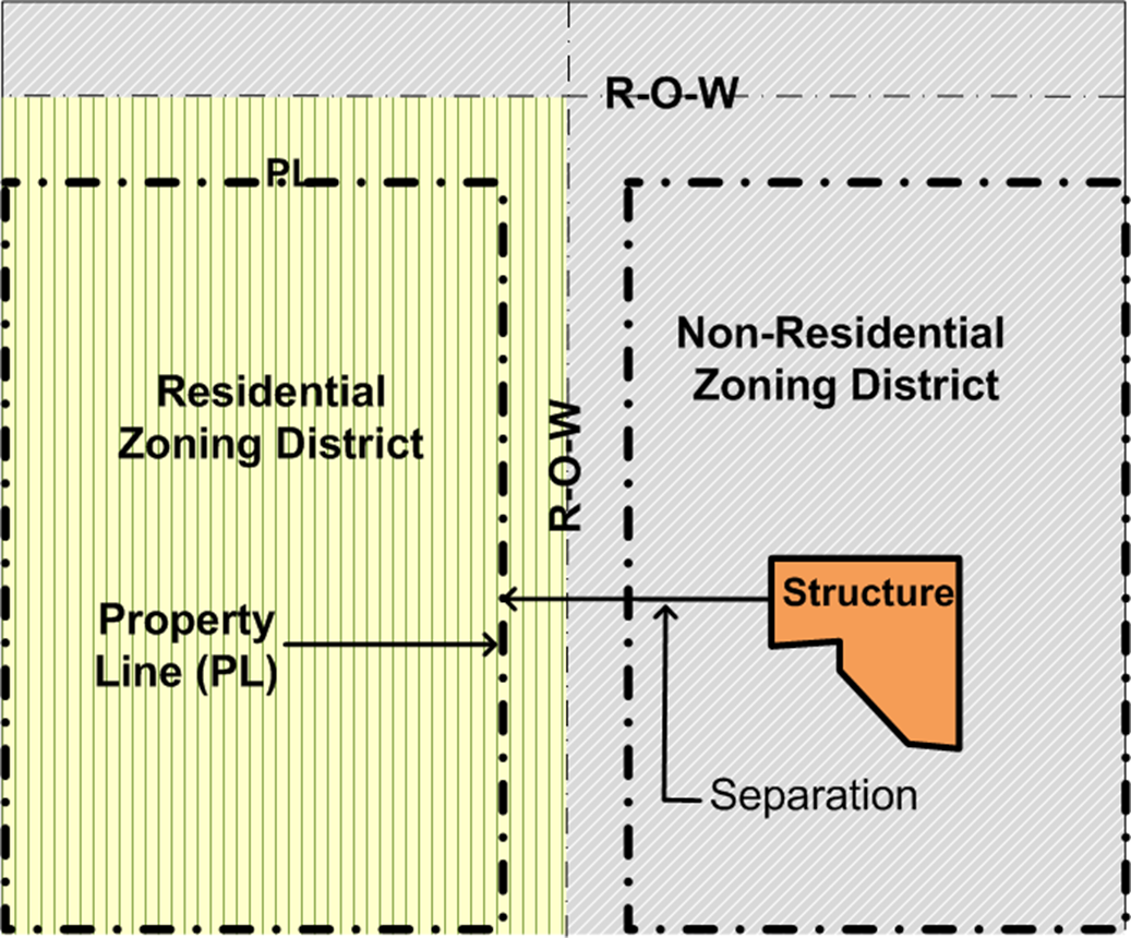
|
|
[Ord. 2018-002]
|
In decibels as defined
in the specific Article and measures for impact from the adjacent property
line.
For the purposes of Art. 1.F, Non-Conformities and Art. 4.B, Use Classification, any fraction of the number of pumps shall
be rounded upward to the nearest whole number for one-half or more of a whole
pump, and downward if it is less than one-half of a whole pump. [Ord.
2010-005]
A polygon drawn tangent
to the extremities of a vertical or horizontal plane and calculated to provide
total acreage or square footage.
|
Figure 1.C.4.J
– Typical Examples of Measurement for Surface Area
|
|
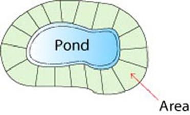
|
For the purpose of determining a building’s transparency requirement,
the following calculation shall be utilized: the height of the first story of
the building, a minimum height of 12 feet above finished grade, multiplied by
the length of the façade and the applicable transparency percentage. The window
or glass door openings including frames and mullions shall be allowed to be
included in the calculation. [Ord. 2010-022]
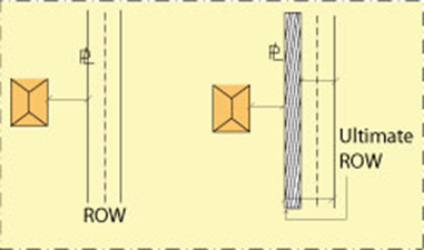
By drawing a straight
line between a site element, use, or structure to the ultimate R-O-W.
|
Figure 1.C.4.L
– Typical Examples of Measurement from Improved R-O-W
|
|
|
By drawing a straight
line between a site element, use, or structure to the base building line.
That portion of a property
conveyed or dedicated for public right-of-way without compensation may be
subsequently included with the subject property for the purpose of density,
intensity, or building coverage calculations. [Ord. 2009-040] [Ord. 2010-005]
The provisions of
this Code are the minimum requirements necessary to accomplish the purposes of
this Code and implement and ensure consistency with the Plan.
A. The effective date of this
Code is January 1, 2004.
B. Applications submitted after
the effective date of this Code shall be reviewed in accordance with the
standards and procedures in this Code.
This Section
establishes the review and approval procedures for: Development Orders or
Permits approved prior to the effective date of this Code and their vested
status, non-conforming site elements of a prior approval, and establish extent
of vested status of the limits of affected area of modifications. [Ord.
2010-005]
All Development Orders,
permits, enforcement orders, ongoing enforcement actions, and all other actions
of the BCC, the ZC, the DRO, Enforcement Boards, all other PBC decision making
and advisory boards, Special Masters, Hearing Officers, and all other PBC
Officials, issued pursuant to the procedures established by prior PBC land
development regulations, shall remain in full force and effect. The uses, site
design, intensity, density, and tabular data shown on a Development Permit that
was approved in accordance with a prior Ordinance, shall not be subject to the
requirements of this Code for any information clearly shown. This information
may be carried forward onto subsequent plans if necessary to implement the
previously approved plan. [Ord. 2010-005] [Ord. 2010-022]
Previously approved Variances,
exemptions, or Waivers from property development regulations and standards no
longer required by this Code shall remain in effect until superseded, modified,
abandoned, voided, or revoked by the authority which granted the original
approval. Such prior approvals may only be used in their entirety, as
originally approved, and may not be amended or modified. [Ord. 2010-005]
A Development Order or Permit,
which was approved under prior Code provisions, shall comply with the current
review process for any modifications and the following: [Ord. 2010-005]
[Ord. 2016-042]
The proposed
modification shall comply with the current Code to the greatest extent possible
in the affected area, which also includes the determination of whether the
prior approval has non-conformities. A prior approval may be subject to rezoning
in accordance with the requirements of Art. 3.A.3, Zoning District Consistency with
the Future Land Use Atlas (FLUA). [Ord. 2010-005] [Ord. 2011-016]
Proposed modifications
may not increase a non-conformity. The Applicant shall identify the extent of
the proposed modification on the applicable plan and in the application
pursuant to Art. 2.A.6.B, Plan Requirements. The application and plan shall: [Ord.
2010-005]
a. list all prior Zoning Resolutions and prior
ULDC amendment Ordinances to establish a record of any prior vesting claim. [Ord. 2010-005]
b. delineate on the plan the boundary of the
affected area and indicate all proposed modifications; if necessary, the Zoning
Director shall render decision on the affected area. [Ord. 2010-005]
c. identify all non-conformities with prior
approved Development Orders, which include: lot, structure, use, and site
elements of the subject property or affected area of the subject property to
establish a record of non-conformities in the tabular data of the plan, and
notate on the plan these non-conformities, where applicable. [Ord. 2010-005]
d. all non-conformities outside of the affected
area that are clearly shown on a prior Development Order shall be vested. [Ord. 2010-005]
Pursuant to F.S.
§ 723.041(4), the placement of any size new or used Mobile Home and
appurtenances on a Mobile Home lot shall be permitted in accordance with the
lot sizes, separation and setback distances, and other requirements in effect
at the time of the approval of the Development Order for the Mobile Home Park,
or any subsequent Development Order Amendment, if applicable. [Ord. 2016-042]
Invalid Development Orders
include those which have been revoked, voided, abandoned, or have expired. If a
Development Order for a parcel of land is invalid, any future Development Order
for that parcel shall be subject to all applicable provisions of this Code. [Ord.
2010-005]
A Development Order
application that is found sufficient for review purposes shall be required to
meet the Code provisions in effect on the date the application is submitted. The
application shall not be required to meet any subsequent Code amendments that
may be adopted prior to final approval of the application by the appropriate
Board or PBC Official. [Ord. 2010-005]
The purpose and intent
of this Chapter is: to establish regulations to address lots, structures, uses,
and site elements that were lawfully established before this Code was adopted
or amended, that now do not conform to the terms and current requirements of
this Code; to regulate and limit the continued existence of such non-conformities;
and, where possible, bring them into conformance with this Code.
In addition, this
Chapter addresses projects within the Redevelopment Areas in Art. 3.B, Overlays
(IRO, URAO, and WCRAO) where new developments and redevelopments are regulated
by form-based design standards. The intent is to provide incentives to
encourage infill and redevelopment in these areas, improve the overall quality
of the surrounding communities, to address any development restrictions unique
to each overlay, and to ensure overall compliance with the general intent of
non-conformity provisions. [Ord. 2010-005] [Ord. 2010-022]
This Chapter applies to
non-conforming lots, structures, uses, and site elements. In determining
whether such non-conformities will be regulated by the provisions of this
Chapter, the following shall apply: [Ord. 2010-005]
1. Non-conforming status shall not be provided
for any: lot, structure, use, or site element, which was illegally created,
commenced, constructed or unlawfully continued, or commenced after the
restrictions, became applicable. [Ord.
2010-005]
2. Non-conforming status shall only be
authorized upon demonstration by the Applicant that a lot, structure, use, or
site element was created, commenced, or constructed, and not merely
contemplated, unless permitted by this Code. [Ord. 2010-005]
a. For a non-conforming use, affidavits alone
are not sufficient evidence to establish non-conforming status. The Applicant
must demonstrate that the use was in continuous operation during business hours
and not an occasional use of the property. The Applicant will be required to
submit a Vested Use Recognition Form established by the Zoning Director to
confirm the use is vested. [Ord.
2010-005]
3. An accessory non-conforming use shall not
become the principal use. [Ord. 2010-005]
Limitations for
maintenance, renovation, and natural disaster damage repair shall not apply to
conforming uses for non-conforming structures, site elements, or lots that have
been granted Waivers from all applicable non-conformities by the BCC in accordance
with Art. 9.B.4.B, Waiver of the Code Provisions, for historic sites. [Ord. 2010-022]
There are four classifications
of improvements that may be made to non-conformities. These include: Expansion,
Maintenance, Renovation, and Natural Disaster Damage Repair pursuant to Art. 1.H.2, Definitions. [Ord. 2010-005]
Improvement Value, as
determined by the Palm Beach County Property Appraiser, is utilized to
calculate allowable improvements for all types of non-conformities listed in
this Chapter. The maximum allowable improvement is based upon the Property
Appraiser’s most recent Improvement Value of the structure as follows: 125
percent for non-government structures including structures in the Redevelopment
Area or in the Overlays, and 185 percent for government structures. A Property
Owner may apply to the Property Appraiser for a re-assessment to obtain the
most recent Improvement Value of the structure. If a new value is established,
it shall be forwarded directly to the Zoning Director from the Property
Appraiser. [Ord. 2010-005]
The International Code
Council’s Building Valuation Data table, which provides the “average”
construction costs per square foot, shall be used as the sole basis in
determining the value of an improvement necessary to perform expansion,
maintenance, renovation, or natural disaster damage repair for any type of non-conformity.
The table is outlined in the most current building valuation data in the
Building Safety Journal, as amended periodically by the International Code
Council. As an alternative to the Building Valuation Data table, an Applicant
may submit other comparable guidelines adopted by law or accepted in practice
by the Building Official. [Ord. 2010-005]
Expansion shall comply
with Table 1.F.1.F, Non-Conformities – Percentage
and Approval Process for Expansion and other applicable Sections of this Chapter. No Variance shall be
permitted beyond the percentages stated in this Table. [Ord. 2010-005]
|
Table 1.F.1.F – Non-Conformities
Percentage
and Approval Process for Expansion
|
|
Improvement Classification
|
|
|
|
|
|
Expansion
|
|
Non-Government and
Government
|
One time only
10% max. allowed with DRO approval.
Shall not be expanded in area it occupies
unless it is being expanded into an area of a structure, which was designed
and approved for such use in a valid Development Order prior to becoming non-conforming.
|
One time only
10% max. allowed with DRO approval.
Shall not exceed 10% max. of approved floor
area of the structure or 10% of the Improvement Value of the structures on
site, whichever is less, or other form of measures pursuant to Art. 1.F.4.D, Expansion.
|
Comply with Code through applicable review
approval process.
Shall not change or increase the non-conforming
features of the structure. Shall not result in the expansion of a non-conforming
use.
|
Comply with applicable Code to greatest
extent possible through applicable review approval process.
|
|
[Ord. 2010-005] [Ord.
2010-022]
|
|
Notes:
|
|
1.
|
Non-conforming
use in a non-conforming structure shall not expand.
|
|
2.
|
Expansion shall be based upon intensity or density pursuant
to Art. 1.F.4.D, Expansion.
|
|
3.
|
Refer to Art. 1.F.5, Non-Conforming Site Element for additional
information.
|
|
|
|
|
|
|
The standards,
limitations, and approval processes for improvements to non-conformities shall
be as follows: [Ord. 2010-005]
1. Maintenance, Renovation, and Natural Disaster
Damage Repair – The total combined value for improvement classifications shall
not exceed the allowable maximum percentage of any single improvement
classification. The percentage of each improvement classification is pursuant
to Table 1.F.1.G, Non-Conformities – Percentage
and Approval Process for Maintenance, Renovation, and Natural Disaster Damage
Repair. [Ord. 2010-005]
2. Maintenance – May be performed in any
12-consecutive month period. [Ord.
2010-005]
3. Renovation and Natural Disaster Damage Repair
– The cumulative changes in Total Value of Improvement are calculated over the
previous five-year period as a non-conforming use or structure is renovated or
repaired for damages. [Ord. 2010-005]
4. Public utility facilities with non-conforming
structures on existing sites shall not be subject to the requirements of this
Chapter. [Ord. 2010-005]
5. For additional requirements for each type of
non-conformity, see applicable Sections of this Chapter. [Ord. 2010-005]
6. No Variance shall be permitted for the
percentages stated in Table 1.F.1.F, Non-Conformities – Percentage
and Approval Process for Expansion. [Ord. 2010-005]
7. Repair for non-natural disaster damage shall
comply with percentage pursuant to Table 1.F.1.F, Non-Conformities – Percentage
and Approval Process for Expansion. [Ord. 2010-005]
|
Table 1.F.1.G – Non-Conformities
Percentage (1) and Approval Process for
Maintenance, Renovation, and Natural Disaster Damage Repair
|
|
Improvement Classifications
|
|
|
|
|
|
Non-Government
|
|
Maintenance
|
≤
20%; By Right
|
≤
30%; By Right
|
≤
20%; By Right
OR
>
20% ≤ 30%; DRO
|
Comply
with applicable Code to greatest extent possible through applicable review
approval process. (5)
|
|
Renovation
|
|
Natural
Disaster Damage Repair
|
|
Government (3)
|
|
Maintenance
|
≤
30%; By Right
|
≤
45%; By Right
|
|
Renovation
|
|
Natural
Disaster Damage Repair
|
|
URAO, WCRAO, IRO (4)
|
|
Maintenance
|
≤
20%; By Right
OR
>
20% ≤ 30%; DRO
|
30%;
By Right
OR
>
30% ≤ 50%; DRO
|
30%;
By Right
OR
>
30% ≤ 50%; DRO
|
|
Renovation
|
|
Natural
Disaster Damage Repair
|
|
[Ord. 2010-005] [Ord. 2010-022]
|
|
Notes:
|
|
1.
|
All percentages shall be
based on the Improvement Value of the structure pursuant to Art.
1.F.1.D, Improvement Value, unless stated otherwise
herein.
|
|
2.
|
For non-conforming use in a conforming or
non-conforming structure, the percentage of the non-conforming use shall
apply.
|
|
3.
|
A higher percentage shall be allowed for
Government structures as appraisals by the Property Appraiser's Office are
conducted less for Government structures due to exemptions for property tax.
|
|
4.
|
A higher percentage shall
be allowed for Redevelopment Areas and Overlays to encourage infill and
redevelopment that requires built forms to regulate uses. All improvements
must comply with applicable Sections of Art. 3.B, Overlays.
|
|
5.
|
If the use or structure is non-conforming,
the maximum allowable percentage for improvements for the site elements shall
be included in the Total Value of Improvements.
|
|
|
|
|
|
|
This Section shall only
apply to non-conforming lots that do not meet the minimum lot acreage and
dimensional criteria pursuant to Table 3.D.1.A, Property Development
Regulations of this Code,
if all of the following conditions are met: [Ord. 2008-037] [Ord. 2010-005]
Where applicable, the
lot or lots have complied with the lot recombination requirements of Plan FLUE
Policy 2.2.1-r, and Art. 11, Subdivision, Platting, and Required
Improvements. [Ord.
2008-037] [Ord. 2010-005] [Ord. 2023-009[
Non-conforming lots may
be combined with any other conforming or non-conforming lot without obtaining Variance
relief for non-conforming lot dimensions, inclusive of frontage, width, depth,
and size, if all of the following conditions are met: [Ord. 2008-037] [Ord.
2010-005]
1. The newly created lot complies with the lot
dimensions of this Code, or reduces the non-conformity; and [Ord. 2008-037] [Ord. 2010-005]
2. Can comply with the requirements of Art. 11, Subdivision, Platting, and Required
Improvements. [Ord. 2008-037] [Ord. 2010-005]
A non-conforming
residential lot may utilize the property development regulations subject to Table 3.D.1.A, Property Development
Regulations. [Ord.
2010-005] [Ord. 2016-042] [Ord. 2023-009]
A non-conforming
structure may continue to exist in accordance with this Section. [Ord.
2010-005]
Expansion of a non-conforming
structure shall not change or increase the non-conforming features of the
structure, and shall not result in the intensification of a non-conforming use
through the structural expansion. Expansion shall not exceed the percentage
pursuant to Table 1.F.1.F, Non-Conformities – Percentage
and Approval Process for Expansion. [Ord. 2010-005]
Maintenance,
renovation, and damage repair caused by acts of nature shall not exceed the
percentage pursuant to Table 1.F.1.G, Non-Conformities – Percentage
and Approval Process for Maintenance, Renovation, and Natural Disaster Damage
Repair. [Ord. 2010-005]
Uses, structures, and
other obstructions permitted prior to the effective date of the Airport
regulations, November 1, 1996, that lie within Regulated Areas defined in Art. 16, Airport Regulations, which do not comply with the Airport Land Use Compatibility Schedule
or FDOT, “Guidelines for the Sound Insulation of Residences Exposed to Aircraft
Operations,” or exceeds permitted height limitations shall be considered a non-conforming
use unless the structure or use is brought into conformance with the provisions
of Art. 16, Airport Regulations. [Ord. 2010-005] [Ord. 2017-025]
a. Exemptions
Land Uses within Regulated
Areas for
PBC Park Airport (Lantana), PBC Glades Airport (Pahokee), Belle Glade Municipal
Airport, and Palm Beach North County Airport are exempt from the requirements of this Article. [Ord. 2010-005] [Ord. 2017-025]
The requirements of Art. 16, Airport Regulations, shall not be construed to necessitate the removal, lowering, or other
modification of a structure or building supporting an existing use non-conforming
to the requirements therein, or otherwise interfere with the continuance of
such use which legally existed prior to November 1, 1996, provided the
continuation does not jeopardize life or health. Construction or alterations
which existed or started prior to November 1, 1996, and are diligently pursued
and completed in accordance with Building Permitting requirements as defined by
PZB, shall not be required to comply with the provisions in Art. 16, Airport Regulations. [Ord. 2010-005] [Ord. 2017-025]
a. Change in Use and Occupancy
If a change of use is
proposed for an existing structure or building which does not comply with the
Airport zoning provisions for that particular use, as specified in the Airport
Land Use Compatibility Schedule, the entire structure or building shall be
brought into conformance with Art. 16, Airport Regulations. [Ord. 2010-005]
A non-conforming use or structure that is intentionally discontinued,
abandoned, or changed shall lose its non-conforming status and shall not be
reestablished or resumed. Any subsequent use or structure in the same location
shall be consistent with this Code. A use or structure that has been
discontinued, abandoned, or changed for a period of more than 180 consecutive
days, or for a total of 540-calendar days during any three-year period, shall
constitute a presumption of the intent to discontinue, abandon, or change the
use or structure. In the event either time period has been exceeded, an Applicant
shall have the burden of rebutting the presumption by presenting competent,
substantial evidence of the intent to maintain the non-conforming use or
structure. [Ord. 2017-025]
a. Height Restrictions
Permits shall not be
granted that would allow an existing structure to become higher or become a
greater hazard to air navigation than it was as of November 1, 1996. All
structures shall comply with Art. 16.B.1, Airspace Height Regulations. [Ord.
2010-005]
b. Use Regulations
Any permits to
substantially modify, repair, restore, reconstruct, or rebuild a structure
supporting a non-conforming use shall comply with Art. 16.C.1.E, General Land Use Regulations
– Off-Airport Land Use Compatibility Schedule (Appendix 8). In such cases, the entire building or
structure shall be brought into conformance with these requirements. For the
purposes of this Article, substantially modify shall mean: [Ord. 2010-005] [Ord. 2017-025]
1) the structure is more than 80 percent torn
down, destroyed, deteriorated, or decayed; or [Ord. 2010-005]
2) the Total Value of Improvement of repair,
reconstruction, or restoration exceeds 50 percent of the Improvement Value of
the existing building or structure. [Ord.
2010-005] [Ord. 2013-001] [Ord. 2017-025]
If the structure does
not meet these criteria, then only the new construction, alteration, or repair
shall be subject to the requirements of Art. 16, Airport Regulations. [Ord. 2010-005]
Buildings or structures
moved into or within Palm Beach County, into a RPZ or ALUNZ shall comply with
the height and noise level reduction provisions in Art. 16, Airport Regulations. [Ord. 2010-005]
Any repair,
restoration, reconstruction or alteration to a non-conforming structure or
establishment of a new use shall require compliance with the Obstruction
Marking and Lighting provisions in Art. 16.B.1, Airspace Height Regulations. [Ord. 2010-005]
There are three classes
of non-conforming uses: Major, Minor, and Non-Conforming to Airport
Regulations. [Ord. 2010-005]
A major non-conforming
use is a use that was legally established in a zoning district where the use is
now prohibited under the terms of this Code. Major non-conforming uses are
inappropriately located and create or threaten to create incompatibilities that
are detrimental to the public welfare. The intent of the PBC Comprehensive Plan
is to eliminate or reduce existing or previously approved land uses, and
activities, which were lawful before the adoption of the Plan but are now
prohibited, regulated, or restricted under the terms of the Plan. [Ord.
2010-005]
A minor non-conforming
use is a use that was legally established in a zoning district under a prior
Code and one or more of the following applies: the use has been changed to a
more restrictive review or approval process under the terms of this Code; DOAs
or improvements to the use would exceed the development and approval
thresholds; or, the use does not meet the property development regulations of
this Code. Minor non-conforming uses do not create or threaten to create
incompatibilities injurious to the public welfare. An Applicant who is
requesting modification or improvement to a minor non-conforming use is
encouraged to apply pursuant to the review and approval process now in effect
to correct the non-conforming status of the use for the benefit of future Development
Order Amendments and other types of improvements. [Ord. 2010-005] [Ord.
2015-006]
Requirements for uses
non-conforming to Airport regulations are set forth in Art. 1.F.3.D, Uses and Structures within an
Airport Zone Established in Article 16. Non-conforming uses that are also non-conforming to the Airport zoning
regulations shall comply with both the non-conforming provisions in this
Chapter and the non-conforming provisions in Art. 16, Airport Regulations. These uses shall be regulated as follows: [Ord. 2010-005] [Ord.
2017-025]
a. A major non-conforming use shall comply with
the major non-conforming use provisions in this Chapter. [Ord. 2010-005] [Ord. 2017-025]
b. A minor non-conforming use shall comply with
both provisions of the minor non-conforming use provisions in this Chapter and
the non-conforming to Airport regulations in Art. 16.C.2, Non-Conforming Uses. [Ord.
2010-005] [Ord. 2017-025]
A non-conforming use
shall not be changed to any other use, unless the new use conforms to this Code.
A non-conforming use physically replaced by a permitted use shall not be reestablished.
[Ord. 2010-005]
A non-conforming use
that is intentionally discontinued, abandoned, or changed to an accessory use
shall lose its non-conforming status and shall not be reestablished or resumed.
Any subsequent use in the same location shall be consistent with this Code. A
use that has been discontinued, abandoned, or changed to an accessory use for a
period of more than 180 consecutive days, or for a total of 540-calendar days
during any three-year period shall constitute a presumption of the intent to
discontinue, abandon, or change to an accessory use. In the event either time
period has been exceeded, an Applicant shall have the burden of rebutting the
presumption by presenting competent, substantial evidence of the intent to
maintain the non-conforming use. [Ord. 2010-005] [Ord. 2017-025]
Expansion shall not
exceed the percentage pursuant to Table 1.F.1.F, Non-Conformities – Percentage
and Approval Process for Expansion. [Ord. 2010-005]
A minor non-conforming
use may be expanded pursuant to Table 1.F.1.F, Non-Conformities – Percentage
and Approval Process for Expansion, and the following: [Ord. 2010-005]
a. The expansion shall not exceed ten percent of
the approved floor area of the structure or ten percent of the Improvement Value
of the structures on site, whichever is less; or any other form of measure of
intensity/density for the specific use such as but not limited to: beds for Congregate
Living Facilities; decks for Restaurants; number of children for Day Cares;
number of fueling stations or gas pumps for Retail Gas and Fuel Sales; or, other traffic intensity measures. [Ord. 2010-005] [Ord. 2017-007]
Shall not exceed the
percentage pursuant to Table 1.F.1.G, Non-Conformities – Percentage
and Approval Process for Maintenance, Renovation, and Natural Disaster Damage
Repair. For natural
disaster damage repair, Improvement Value shall be established at the time the
damage occurred. [Ord. 2010-005]
See Figure 1.F.4, Relocation and Expansion for permitted relocation of non-conformities. A non-conforming use
shall not be relocated. [Ord. 2010-005]
This Section
establishes procedures for improvements and modifications to a prior approval
with non-conforming site elements and establishes thresholds for vesting non-conformities.
This Section shall apply to non-conforming site elements, including but not
limited to: Art. 5.E.4.E, Outdoor Lighting, Art. 6, Parking, Loading, and Circulation, Art. 7, Landscaping,
and Art. 8, Signage that may be impacted by proposed
improvements or modifications to a prior approval. In addition, this Section
shall also apply to projects that meet the threshold pursuant to Art. 5.B, Accessory Uses and Structures and Art. 5.C, Design Standards, and those that are subject to Art. 16, Airport Regulations. [Ord.
2010-005] [Ord. 2019-005]
Proposed modification
or improvement to a project where the use or structure is conforming or has
been brought into conformance with this Code through an applicable approval
process, and where only the site elements are non-conforming, the following
requirements shall be met: [Ord. 2010-005]
A project without an
approved plan shall comply with this Code. [Ord. 2010-005]
An unbuilt project with
an approved plan shall only comply with Art. 6, Parking, Loading, and Circulation, Art. 7, Landscaping,
and Art. 8, Signage in the affected area to the greatest extent
possible without the loss of density, intensity, or required parking. [Ord.
2010-005]
Projects, which have
commenced development or have been constructed, shall comply with the
requirements of this Code and the following: [Ord. 2010-005]
a. Projects with 80 percent or more of the
approved density or intensity (number of units, square feet, or footprint of
buildings) constructed shall remain valid for any information and items clearly
shown on the approved Development Order. The affected area shall meet this Code
to the greatest extent possible. [Ord.
2010-005]
b. Projects with less than 80 percent of the
approved density or intensity constructed shall comply with Art. 6, Parking, Loading, and Circulation, Art. 7, Landscaping,
and Art. 8, Signage in the affected area to the greatest extent
possible without the loss of density, intensity, or required parking. [Ord. 2010-005]
When improvements are
proposed to a conforming structure with a conforming use, the associated non-conforming
site elements must also be improved to comply with current Code requirements (see
Zoning Division Technical Manual for examples). The required improvements shall
be determined based on the Improvement Value of the structure pursuant to Table 1.F.5, Thresholds for Improvements –
Non-Conforming Site Elements.
These improvements are required in addition to the standards pursuant to Art. 1.F.5.B.3, Built Projects with an
Approved Plan. [Ord.
2010-005]
|
Table 1.F.5 – Thresholds for Improvements
Non-Conforming
Site Elements
|
|
Use or Structure
|
Percentage (1)(2)
|
|
|
Non-Government
|
> 35%
|
Art. 5.E.4.E, Outdoor
Lighting
|
|
Art. 6, Parking,
Loading, and Circulation
|
|
Art. 7, Landscaping
|
|
Art. 8, Signage
|
|
> 75%
|
In addition to the above requirements:
|
|
Art. 5.C, Design
Standards, if applicable
|
|
Art. 5.B.1.A.19,
Permanent Generators, if applicable
|
|
Government (3)
|
> 100%
|
Art. 5.E.4.E, Outdoor
Lighting
|
|
Art. 6, Parking,
Loading, and Circulation
|
|
Art. 7, Landscaping
|
|
Art. 8, Signage
|
|
Art. 5.C, Design
Standards, if applicable
|
|
Art. 5.B.1.A.19,
Permanent Generators, if applicable
|
|
[Ord. 2010-005]
|
|
Notes:
|
|
1.
|
The
percentage is based on the Improvement Value of conforming structure(s).
|
|
2.
|
The
percentage applies to improvements for a conforming use or structure with non-conforming
site elements. If the use or structure is non-conforming, the maximum
allowable percentage shall comply with Table 1.F.1.F, Non-Conformities –
Percentage and Approval Process for Expansion.
|
|
3.
|
Applies
only to exterior renovations or additions to existing buildings and
structures.
|
|
|
|
|
Stand-alone improvements
to non-conforming site elements shall comply with Art. 1.F.5.B, Modification or Improvement to
a Prior Approval with Non-Conforming Site Elements in the affected area, to the greatest
extent possible, and the following, where applicable: [Ord. 2010-005]
Alterations or
additions to outdoor lighting shall comply with Art. 5.E.4.E, Outdoor Lighting. [Ord. 2010-005]
Alterations or
additions to vehicular use areas shall comply with Art. 5.E.4.E, Outdoor Lighting Standards, Art. 6, Parking, Loading, and Circulation, and Art. 7, Landscaping.
[Ord. 2010-005]
a. Non-Residential PDDs and TMDs
Parking Calculation
Proposed modifications
to a previously approved development, whether modifications are for the entire
or a portion of the development, shall be in compliance with the following: [Ord. 2010-005]
1) the minimum parking requirements pursuant to
the non-residential parking requirements of Art. 3.E.1.C.2.h, Parking; and [Ord.
2010-005]
2) applicable Sections of Art. 7, Landscaping.
[Ord. 2010-005]
Approved signs as shown
on plans or pursuant to conditions of an approval shall remain valid. Renovations
or additions to a sign shall be in compliance with Art. 8, Signage. The
maximum percentage of improvements for a non-conforming sign shall be based on
the original value of the previously approved sign. [Ord. 2010-005]
Approved Landscape Plans
shall remain valid unless the development is amended or modified. The affected
area of the amended or modified plans shall be subject to Art. 7, Landscaping
to the greatest extent possible. All plans shall also be subject to Art. 14.C, Vegetation Preservation and Protection. [Ord. 2010-005]
For the purposes of
this Code, an eminent domain action occurs when property is acquired through an
eminent domain proceeding or where such property is voluntarily conveyed under
the threat of condemnation to a condemning authority. This Section shall apply
to all properties impacted by an eminent domain action. Site improvements and
conditions, including non-conforming features and uses existing prior to the
time of the eminent domain action shall not be affected by this Section. This
Section alone shall not cause a specific use on a property impacted by an eminent
domain action to cease.
Properties and site
improvements impacted by eminent domain action may continue to exist and may
expand as outlined below.
Where, due to an
eminent domain action, a reduction in the size of a lot causes a reduction
below the required lot area, setbacks, parking, landscaping, sign location, or
other development regulations in this Code, the structure(s) on the property,
the use(s) within the structure(s), and other site improvements may continue to
exist in the configuration remaining after the condemnation, except that:
a. Access
The length of access
ways shall not be less than ten feet measured from the R-O-W, unless otherwise
approved by the County Engineer; and
b. Direction
Ingress and egress to
and from the site shall be in a forward direction.
A structure or other
site improvement located on property reduced by an eminent domain action may be
enlarged or expanded if the enlarged or expanded portion meets the requirements
of this Code.
a. Parking
Parking for the new use
shall utilize the excess spaces, if any provided for the existing use.
1) For the purpose of determining the required
parking, the Code in effect at the time of the enlargement or change in use
shall be used.
2) There shall be no reduction in required
spaces designated for physically disabled persons. Where parking is reduced,
the use of off-site parking, cross-parking agreements, and shared parking
agreements are encouraged.
Redesign of sites, at
any time, is encouraged for the purposes of achieving safer sites and enhanced
landscaping along roadways. Site improvements may be relocated or replaced
elsewhere on site and shall be approved if the redesign meets current Code
requirements, unless otherwise stated in this Section. Redesign shall follow
the permitting procedures of this Code, except for provisions specifically
identified in this Section.
a. Variance Required for New
Deviation from Regulations
A Variance shall be
obtained for any additional deviation from required property development
regulations or site design standards proposed by the redesign. Any redesign or
expansion which reduces an existing deviation from required property
development regulations or site design standards shall not require a Variance.
When applying the Variance Standards in Art. 2.B.7.E, Type 2 Variance, and Art. 2.C.5.F, Type 1 Variance, the eminent domain action shall be
presumed to be sufficient evidence to demonstrate a hardship (only applies to
Type 2 Variance Standard d listed under Art. 2.B.7.E.6, Standards for Zoning or
Subdivision Variance). To
encourage site redesign, in cases when a DRO Site Plan approval and a Variance
would both be required, only a Variance shall be required. [Ord. 2010-022] [Ord. 2014-001]
b. Modification of Zoning
Commissions ZC or BCC-Approved Plans
Where a proposed
redesign is located on property that is the subject of a plan approved by the
ZC or BCC, redesign shall be approved by the DRO even if the redesign is in
excess of the limitations in Art. 2.C.5.C, Administrative Modifications
to Prior DOs. Conditions
imposed by the ZC or BCC shall not be amended without ZC or BCC approval,
whichever is applicable.
c. Parking Area Reduction
If site redesign
involves either a lot combination, vehicular use area, or alteration required
by this Section, a reduction of up to 35 percent of the required spaces shall
be permitted provided:
1) The access standards of Art. 6.B.3.A.2.a.3), Driveways and Access are met; and
2) A minimum of five feet wide landscape buffer
with landscaping as required in Art. 7, Landscaping,
is installed along the frontage of the property.
A structure subject to
this Section which becomes damaged may be reconstructed in the location and
manner as it legally existed before the eminent domain action except that a
structure that is destroyed or damaged in excess of more than 50 percent of its
value at the time of reconstruction shall be considered a vacant lot pursuant
to Art. 1.G.1.B.6, Lots Reduced by Eminent
Domain. In determining the
value of such a structure, the standards and procedures described in Art. 1.F.3, Non-Conforming Structure, shall be used.
Any existing, legally
established point of purchase or freestanding sign located on the property
included in the eminent domain action may be relocated on site subject to the
standards of this Section provided any sign(s) to be relocated shall comply
with the requirements of this Code and the following criteria: [Ord.
2005-002]
a. Sign Number and Size
Any sign(s) to be
relocated shall comply with the height, size (face area), and maximum number of
signs allowed in accordance with the requirements of the Code. [Ord.
2005-002]
In no event shall the
front setback be less than five feet from the ultimate R-O-W and have less than
a two-foot side setback, except upon issuance of a sign relocation permit. [Ord. 2005-002]
c. Sign Relocation Permit
Signs that must be
relocated which are physically precluded from compliance with the setback
requirements in Art. 1.G.1.B.5.b, Sign Relocation, above may obtain, upon payment of a fee, a
sign relocation certificate from the Zoning Director subject to this Subsection.
The Zoning Director shall issue a sign relocation certificate provided the Applicant
can meet the following standards: [Ord. 2005-002]
1) The sign relocation in accordance with Art. 1.G.1.B.5.b, Sign Relocation, above, would not create additional loss in
the number of required parking spaces; [Ord. 2005-002]
2) The proposed sign location does not encroach
into the R-O-W, unless it is part of negotiated settlement with the condemning authority;
and, [Ord. 2005-002]
3) There is no other location on the subject
property to place the sign consistent with safe vehicular use area design. [Ord.
2005-002]
A lot reduced by an
eminent domain action to any size or configuration below that required by the
applicable zoning district may be developed, subject to the following: [Ord.
2014-001]
a. Uses subject to lot size requirements in Art. 4.B, Use Classification, shall comply with those standards. Type 2
Variance relief may be requested from this requirement if it cannot be met as a
result of the eminent domain action; and [Ord.
2014-001]
b. In all cases,
required district setbacks shall be used.
Lot combinations are
encouraged for the purposes of creating safer, more functional and
aesthetically pleasing developments, and attaining a greater degree of
compliance with Code requirements. This Section may apply to the combined lots
whether or not they are owned by the same person. Combined lots may be
considered as a single lot for the purposes of applying property development
regulations, provided either a cross-parking or cross-access agreement is
executed. The agreement shall be made in the form acceptable to the County
Attorney and recorded in the Official Records of PBC. Lot combination shall
follow the permitting requirements and procedures of this Code, except as provided
below:
a. Parking Credit
Except as provided
below, required parking for combined lots may be administratively reduced by up
to 20 percent upon approval by the DRO of a Site Plan which reduces the number
of access points and the execution of a Unity of Control which includes a cross-parking
or cross-access agreement.
b. Razed Lots
Lots which have been
combined and where all principal structures have been demolished shall be
considered a vacant lot pursuant to Art. 1.G.1.B.6, Lots Reduced by Eminent
Domain.
c. Sites Subject to Approved Site
Plans or Certificates of Conformity
For properties, which
are the subject of a valid Certificate of Conformity, the Certificate may be
amended, upon application by the Property Owner and approval of the DRO, to
allow the combination and the configuration shown on the Certificate may be
implemented. Where a proposed lot combination is located on property which is
the subject of a Site Plan approved by the BCC, combination may be approved by
the DRO even if the redesign proposes Site Plan changes in excess of the
administrative limits contained in Art. 2.C.5.C, Administrative Modifications
to Prior DOs, of this Code.
Conditions imposed by the BCC shall not be amended without BCC approval.
A Certificate of Conformity issued pursuant to either Ordinance
No. 73-2, as amended, or Ordinance No. 92-20, as amended through June 1993,
shall be honored provided the Certificate of Conformity was issued to the Property
Owner, or a notice of intent to issue a Certificate of Conformity was signed by
the Property Owner before June 30, 1994 and is presently on file at the Zoning
Division.
A. Terms
in this Code shall have the following definitions. Supplemental terms and
definitions are defined in specific Articles and/or their Chapters. The
definitions outlined in this Article apply to all Articles, unless specifically
outlined in the respective Article. If a conflict exists in terms between
Articles, the terms defined in the specific Article shall apply.
B. All provisions, terms, phrases, and
expressions contained in this Code shall be liberally construed in order that
the true intent and meaning of the BCC as established in the Plan may be fully
carried out. Terms used in these regulations, unless otherwise specifically
provided, shall have the meanings prescribed by the Statutes of the State of
Florida for the same terms.
C. In the interpretation and application of any
provision of this Code it shall be held to be the minimum requirements adopted
for the promotion of the public health, safety, comfort, convenience, and
general welfare. Where any provision of this Code imposes greater restrictions
upon the subject matter than a general provision imposed by the Plan or another
provision of this Code, the provision imposing the greater restriction or
regulation shall be deemed to be controlling.
A. Terms
defined herein or referenced Article shall have the following meanings:
1. A-Weighted
Sound Pressure Level – for the
purposes of Art.
5, Supplementary Standards, the sound pressure level as measured with
a sound level meter using the A-Weighting network. The standard notation is dB.
2. Abandon – given up, unused, vacant, or not
occupied for the purpose it was originally intended.
3. Abandoned
Tower – any Commercial Communication
Tower whose principal use has been discontinued for a period in excess of three
months.
4. Abutting
Property – lying immediately
adjacent to and sharing a common property line with other property.
5. Accent
Lighting – for the purposes of Art. 5.E.4.E, Outdoor
Lighting, shall mean lighting used to accent a
sculpture, trellis, waterfalls, statue, footbridge, rock outcrop, fountain, or
other similar feature and landscaping. [Ord. 2008-037]
6. Access,
Legal – the principal means of
access from a lot to a public street or to a private street over which a
perpetual ingress and egress easement or R-O-W has been granted to the owners
of any lot serviced by such street.
7. Access
Way – a non-dedicated area that
is permitted for ingress or egress of vehicles or pedestrians. An access way is
permitted to traverse a required landscape buffer. [Ord. 2017-025]
8. Accessory
Agricultural Uses – for the
purposes of Art.
4.B, Use Classification, these uses include “U-Pick-Em” operations;
sale of on-site produced products; corrals; pens; training facilities; dipping
vats; processing of raw material; storage sheds; repair, fabrication, body work,
and welding of agricultural equipment; freestanding coolers; bulk storage of
petroleum products; shipping containers used for temporary storage; washing,
cutting, and packing of farm products; canning, dehydration, and basic
preparation of raw food products prior to shipment; and, outdoor storage of
equipment. [Ord. 2005-002]
9. Accessory
Building or Appurtenant Structure –
for the purposes of Art. 18, Flood Damage
Prevention, a Structure that is located on the same
parcel of property as a principal Structure and the use of which is incidental
to the use of the principal Structure. Accessory Structures should constitute a
minimal investment not to exceed 25 percent of the value of the primary Structure,
shall not be used for human habitation, and be designed to have minimal flood
damage potential. Examples of Accessory Buildings or Appurtenant Structures for
flood damage purposes are detached garages, carports, storage sheds, and barns.
All Structures used for human occupancy shall be deemed principal Structures
and shall comply with these regulations, and not be defined as an Accessory
Building or Appurtenant Structure. [Ord. 2004-013]
10. Accessory
Building or Structure – a
detached, subordinate structure meeting all property development regulations
(PDRs), the use of which is clearly incidental and related to that of the principal
building or use of the land, and which is located on the same lot as that of
the principal building or use.
11. Accessory
Overnight Accommodation (AOA) – a
limited-service overnight facility for visiting researchers, scientists, and
dignitaries. [Ord. 2004-040]
12. Accessory Retail – where a Retail Sales
use is not the principal use, but may be permitted as an accessory use. [Ord. 2010-005]
13. Accessory
Use – see Uses, Accessory.
14. Acre – land or water consisting of 43,560
square feet.
15. Acreage,
Gross – the total land area,
including all public and private areas, within the legal boundaries of a
particular parcel of land or project.
16. Act – the Local Government Comprehensive
Planning and Land Development Regulation Act, F.S.
§ 163.3161 et
seq.
17. Adaptive
Use – for the purposes of Art. 9, Archaeological
and Historic Preservation, the process of converting a building to a
use other than that which it was originally designed.
18. Addition – any walled and
roofed expansion to the perimeter of an existing building. Expansion shall be
connected by a roofline, foundation, and a common load-bearing wall of an
existing building. Any walled and roofed expansion, which is connected by a
firewall or is separated by independent perimeter load-bearing walls, is
considered as new construction, and not an addition. An expansion that is
connected to an existing building by a breezeway shall be considered an
accessory structure. [Ord. 2018-018]
19. Adequate
Protection by Treatment – for
the purposes of Art. 15, Health
Regulations, any one or any combination of the
controlled processes of coagulation, sedimentation, absorption, filtration, or
other processes in addition to disinfection which produces water consistently
meeting the requirements of the Article including processes which are
appropriate to the source of supply.
20. Adjacent
Parcel of Land – a parcel of
land that has all or part of a boundary in common with another parcel,
including point to point, or is separated from such parcel by a street,
easement, R-O-W, waterway, park, or other minor geographical division. [Ord.
2008-037]
21. Administrative
Inquiry – a request by PBC
Officials to the Board of County Commissioners (BCC) for direction on
procedural matters or to resolve inconsistencies in a Development Order; or to
provide status or an inquiry of a specific site when the monitoring provisions
of Art.
2.E, Monitoring of Development Orders (DOs) and Conditions of Approval
are not applicable. [Ord. 2011-016] [Ord. 2017-002]
22. Adopted
Level of Service (LOS) – for the
purposes of Art. 12, Traffic
Performance Standards, LOS D; except as specifically set forth by
the Plan or pursuant to Policies of the Transportation Element. For Test 2 it
is LOS E except as set forth by the Plan.
23. Adverse
Effect – for the purposes of Art. 9, Archaeological
and Historic Preservation, any action which will significantly alter
or destroy a historic resource. [Ord. 2008-037]
24. Adverse
Impact – for the purposes of Art. 18, Flood Damage
Prevention, the increased probability of damage to Structures
from flooding or from floodwater erosion.
[Ord. 2004-013]
25. Aerobic
Treatment Unit – for the
purposes of Art.
15.A, PBC Environmental Control Rule I – Onsite Sewage Programs (OSP),
as defined by Chapter
62-6, F.A.C. [Ord.
2022-019]
26. Aeronautical
Study – a Federal Aviation Administration study, conducted in accordance
with the standards of 14 CFR 77, Subpart C, and Federal Aviation Administration policy
and guidance, on the effect of proposed construction or alteration upon the
operation of air navigation facilities and the safe and efficient use of
navigable airspace. [Ord. 2017-025]
27. Affected Area – for the purposes of Art. 1.E, Prior
Approvals, the area on a plan or a development that
is subject to the proposed modification, including but not limited to: lot,
structures, uses, or site elements. [Ord.
2010-005]
28. Affidavit
of Exemption – for the purposes
of Art.
2, Application Processes and Procedures, a
document, recorded in the Public Record, evidencing the grant of an exemption
for an unrecorded subdivision existing prior to February 5, 1973, from the
provisions of the former PBC Subdivision and Platting Regulations (Ordinance
No. 73-4), as amended, granted pursuant to said regulations.
29. Affidavit
of Waiver – for the purposes of Art.
11, Subdivision, Platting, and Required Improvements, a
document evidencing the grant of an exception to the platting requirement or
the required improvements installation requirement.
30. Affordable
Housing – a dwelling unit for
which a household spends no more than 30 percent of its gross income for
housing costs. Rental housing costs include contract rent and utilities. Owner-occupied
housing costs include mortgage principal and interest, property taxes,
insurance, and, where applicable, Homeowner's Association fees. The current
median income for PBC and income categories established within the Plan are
available at the Planning Division.
31. Affordable Housing Program – a
voluntary program used by an Applicant seeking additional density for an
affordable housing development. [Ord.
2009-040]
32. Aggrieved
or Adversely Affected Person – any
Person or Local Government which will suffer an adverse effect to an interest
protected or furthered by the Plan, including interests related to health and
safety, police and fire protection systems, densities or intensities of
development, transportation facilities, health care facilities, or
environmental or natural resources. The alleged adverse effect may be shared in
common with other members of the community at large, but shall exceed in degree
the general interest in common good shared by all Persons.
33. AGR-PUD
Gross Site Area – the land area
of the PUD less land dedicated per the Thoroughfare Identification Map. The
gross site area includes land to be used for other R-O-W, streets, Preservation
Areas, Development Areas, water retention, open space, commercial, recreation,
and civic uses.
34. AGR-PUD
Preservation Area – land
contained in the Preservation Pod preserved in perpetuity to Bona Fide Agriculture,
fallow land, water preserve areas, wetlands, or uplands.
35. AGR-PUD
60/40 Development Area – that
portion of the PUD which contains the Residential, Recreation, Civic, and Commercial
Pods with support facilities such as streets, internal open space, and
stormwater retention areas.
36. AGR-PUD 80/20 Development Area – that portion of the PUD which
contains the Residential, Recreational, Civic, and Commercial Pods.
37. Agriculture,
Food Processing – a facility for
the canning, dehydration, and basic preparation of raw food products, such as
the washing and cutting prior to shipment.
38. Air
Rights – the right to use space
above ground level.
39. Air
Space – for the purposes of Art.
15.A, PBC Environmental Control Rule I – Onsite Sewage Programs (OSP),
the distance from the liquid level up to the inside top of a treatment
receptacle. [Ord. 2022-019]
40. Air
Stripper – a temporary remedial
system which treats contaminated groundwater.
41. Aircraft – any vehicle which is used or
designed for navigation of or flight in the air.
42. Airport – for the purposes of Art. 16, Airport Regulations, any area of land or water designed and set aside for the taking off,
maneuvering, and landing of aircraft and used or to be used in the interest of
the public for such purpose, including Palm Beach
International Airport (PBIA), Park Airport (Lantana), PBC Glades Airport
(Pahokee), Belle Glade Municipal Airport, Palm Beach North County Airport, and
Boca Raton Airport and any area owned or operated by PBC, or other public
entity, validly licensed by the State of Florida for public use. [Ord. 2017-025]
43. Airport
Elevation – for the purposes of Art. 16, Airport
Regulations, the highest point of an airport's usable
landing area measured in feet above mean sea level (AMSL).
44. Airport
Hazard – for the purposes of Art. 16, Airport Regulations, an obstruction to air navigation which effects the
safe and efficient use of navigable airspace or the operation of planned or
existing air navigation and communication facilities. [Ord. 2017-025]
45. Airport
Hazard Area – for the purposes
of Art.
16, Airport Regulations, any area of land or water upon which an
airport hazard might be established. [Ord.
2017-025]
46. Airport
Land Use Compatibility Zoning – for the purposes of Art. 16, Airport Regulations, Airport Zoning regulations governing the use of land on,
adjacent to, or in the immediate vicinity of airports. [Ord. 2017-025]
47. Airport Layout Plan – for the purposes
of Art. 16, Airport Regulations, a set of scaled drawings that provide a graphic
representation of the existing and future development plan for the airport and
demonstrate the preservation and continuity of safety, utility, and efficiency
of the airport. [Ord.
2017-025]
48. Airport
Master Plan – a
comprehensive plan for an airport which typically describes current and future
plans for airport development designed to support existing and future aviation
demand. [Ord. 2017-025]
49. Airport
Obstruction – for the
purposes of Art. 16, Airport
Regulations, any existing or proposed permanent
or temporary object, natural growth or terrain, or structure construction or
alteration which would exceed the Federal obstruction
standards as contained in 14 CFR 77, Subpart C (as may be amended from time to time). [Ord. 2017-025]
50. Airport
Protection Zoning Regulations – for the purposes of Art. 16, Airport Regulations, means Airport Zoning regulations governing airport hazards. [Ord. 2019-005]
51. Airspace
Height – for the purposes of Art. 16, Airport
Regulations, the height limits as established and set
forth in the Article. Above Mean Sea Level (AMSL) elevation shall be the datum
unless otherwise specified.
52. Alley
– a R-O-W providing a secondary means of access to property that is not
intended or used for principal traffic circulation.
a. a
R-O-W providing a secondary means of access to property that is not intended or
used for principal traffic circulation. [Ord.
2010-022]
b. for
the purposes of the Priority Redevelopment Areas, may provide for primary
vehicular access to a building, parking, and service areas. [Ord. 2010-022]
53. Alteration
a. For
the purposes of Art. 9, Archaeological
and Historic Preservation, any change affecting the exterior
appearance of an existing structure or improvement by additions,
reconstruction, remodeling, maintenance, or structural changes involving
changes in form, texture, materials, or color or any such changes in appearance
in specially designated historic sites, or historic interiors;
b. For
the purposes of Art. 14.C, Vegetation
Preservation and Protection, human-caused activity that modifies,
transforms, or otherwise changes the vegetation, including, but not limited to:
1) Removal,
displacement, mowing, or disturbance (severe pruning, hatracking or internodal
cutting, or poisoning) of vegetation excluding prescribed burns for the
management of native vegetation communities;
2) Removal,
displacement, demucking, or disturbance of soil, rock, minerals, or water
within the plant’s root zone;
3) Introduction
of livestock for grazing; [Ord. 2005-003]
4) Placement
of vehicles, structures, debris, fill, or other material objects thereon,
including introduction or injection of water and other substances; and,
5) Use
of mechanical equipment within the plant’s root zone.
c. For the purposes of Art. 16, Airport Regulations, modification to any permanent or temporary existing structure
by a change in the structure's height, including appurtenances, lateral
dimensions, and equipment or materials used in the structure. [Ord. 2019-005]
54. Alteration,
Building – any change in the structure which will increase the number of
dwelling units, the floor area, or height of the structure.
55. Alteration
of a Watercourse – for the
purposes of Art. 18, Flood Damage Prevention, a dam, impoundment, channel relocation,
change in channel alignment, channelization, or change in cross-sectional area
of the channel or the channel capacity, or any other form of modification which
may alter, impede, retard, or change the direction and/or velocity of the
riverine flow of water during conditions of the Base Flood. [Ord. 2017-026]
56. Alteration
or Materially Alter – for the purposes of Art.
14.A, Sea Turtle Protection and Sand Preservation,
the removal of sand from the Sand Preservation Zone (SPZ).
57. Alternative
Landscape Plan (ALP) – a plan showing the location, quantity, and species
of plants to be installed at non-residential, Multifamily, or residential
planned developments. This plan shall be designed to preserve and incorporate existing
native vegetation in excess of minimum standards or demonstrate innovative use
of plant material and improve site design.
58. Ambulatory
Surgical Center – an
establishment primarily providing elective surgical care, in which the patient
is admitted to and discharged within the same working day and is not permitted
to stay overnight; and which is not part of a Hospital. [Ord. 2017-007]
59. Animal Control Facility – a government-owned facility charged
with enforcement of all Local, State, and Federal laws pertaining to animals or
animal welfare, operation of an animal shelter(s), licensing of certain
animals, investigations for dangerous dogs and animal-to-human bites,
impoundment of stray or unwanted animals, disposition and adoption of animals,
licensing and permitting of animal businesses as outlined in Palm Beach County Ordinance
No. 98-22, as may be amended, administration and
oversight of animal welfare and animal issues that relate to animal protection,
public safety, and public health, rabies surveillance and vaccination programs,
development of local standards for both public and private animal shelters and
animal rescue organizations, and development and oversight of pet
overpopulation programs. [Ord. 2008-037]
60. Animal Shelter – a not-for-profit institutional establishment regulated by
ACC Ordinance
No. 98-22, as amended, as a humane society, or
private animal non-profit organization on two and one-half acres or more or
when open to the public, that is used for the protection of unwanted or
abandoned domesticated animals, the use of which may include sheltering,
adoption, fostering, providing rescue or old age homes, medical or behavioral
rehabilitation, or other accessory uses as may be permitted by ACC that are not
regulated elsewhere by this Code. [Ord.
2008-037]
61. ANSI
– the American National Standards Institute or its successor bodies.
62. Antenna
Height – the overall vertical length of the antenna and antenna support
structure above grade, or if such system is located on a building, then the
overall vertical length includes the height of the building upon which the
structure is mounted. In the event a retractable or demountable-type antenna
support structure is utilized, the antenna height is to be calculated as the
overall vertical length of the antenna and antenna support structure when fully
extended.
63. Antenna
Support Structure – any structure, mast, pole, tripod, or tower utilized
for the purpose of supporting an antenna or antennas.
64. Antiquated
Subdivision – as defined in the Plan.
65. Appeal – for the purposes of Art. 18, Flood Damage Prevention, a request for a review of the Floodplain
Administrator’s interpretation of any provision of the Article, which is filed
with the Flood Damage Prevention Board. [Ord.
2017-025]
66. Applicant
a. The
owner of record, the Agent pursuant to an Agent's agreement acceptable to the
County Attorney, or the mortgagor in the case of bankruptcy.
b. For
the purposes of Art. 12, Traffic
Performance Standards, person seeking a Site Specific Development
Order. In the Unincorporated Area, it consists of those Development Orders for
which a Concurrency Certificate or Concurrency Exemption Determination is
required.
67. Approach
Zone – for the purposes of Art. 16, Airport
Regulations, an area longitudinally centered on the
extended runway centerline and extending outward and upward from each end of
the Primary Zone. An Approach Zone is designated for each runway based upon the
type of approach available or planned for that runway end.
68. Appurtenance
– for the purposes of Art. 9, Archaeological
and Historic Preservation, a part, possession, or other incidental
part which is generally subordinate to, or adjoins the principal use of
structure, i.e. fences, walls, steps, paving, sidewalks, signs, and light
fixtures.
69. Aquifer
– a groundwater-bearing geologic formation, or formations, that contain
enough saturated permeable material to yield significant quantities of water.
70. Arcaded
Sidewalk – a covered pedestrian walkway contiguous to a street, plaza, or
square that is open to the public and includes usable floor area above the roof
of the arcade. [Ord. 2006-004] [Ord.
2010-022]
71. Archaeological
Evaluation Report – for the purposes of Art. 9, Archaeological
and Historic Preservation, a letter prepared by the County
Archaeologist evaluating the potential significance of an archaeological site
after issuance of a suspension order by the Department.
72. Archaeological
Resources – all evidences of past human occupations which can be used to
reconstruct the life ways of past peoples and evidence of past animal life in
the form of non-human vertebrate fossils. These include sites, artifacts,
environmental, and all other relevant information and the contexts in which
they occur. Archaeological resources are found in prehistoric and historic period
sites and areas of occupation and activity.
73. Archaeological
Site – property or location which has yielded or might yield information on
PBC, the State, or Nation's history or prehistory. Archaeological sites are
evidenced by the presence of artifacts and features on or below the ground
surface indicating the past use of a location at least 75 years ago by people
or the presence of non-human vertebrate fossils. Archaeological sites include
aboriginal mounds, forts, earthworks, village locations, camp sites, middens,
burial mounds, missions, historic or prehistoric ruins which are, or may be the
source of artifacts or other items of significant archaeological value.
74. Archaeologist,
Qualified – a member of, or qualified for membership in the Florida
Archaeological Council (FAC), or the Society of Professional Archaeologists
(SOPA), Registry of Professional Archaeologists (RPA), or a person who meets
the minimum professional requirements for an archaeologist as set by the United
States Secretary of the Interior. [Ord. 2008-037]
75. Architectural Features – for the purposes of Art. 9, Archaeological
and Historic Preservation, architectural features include the
architectural style, scale, massing, sitting, general design, and general
arrangement of the exterior of the building or structure, including the type,
style, and color of roofs, type and texture of building material, public access
open courtyards, windows, doors, and appurtenances. These features will include
interior spaces where the interior has been given historic designation under
the procedures listed in Art.
9.B.3.A, Application for Historic Site or District Designation.
76. Architectural
Terms – for the purposes of Art. 5.C, Design
Standards.
a. Architect – a person licensed to engage in the practice of architecture
under F.S.
ch. 481, pt. I, and includes the term “Registered Architect.”
[Ord. 2009-040]
b. Architectural Compatibility – similar architectural
composition that is agreeable, consistent, complimentary, and provides a degree
of architectural integration with the structures in the surrounding area. Particular
attention should be given to scale, proportion, unity, harmony, and context. [Ord. 2009-040]
c. Architectural Composition – the scale, height, mass,
proportion, color, form, style, detail, treatment, texture, construction
material, and roof design of a project or building. [Ord. 2009-040]
d. Architectural Style Sheets – examples of various
architectural elements and components that define a particular character,
style, or classification of architecture. [Ord.
2009-040]
e. Balance – the pleasing or harmonious arrangement or proportion of
parts or elements in a design or composition. [Ord. 2009-040]
f. Green Architecture – a building designed to limit its environmental impact
through environmentally conscious methods of design and construction. The focus
shall pertain to the exterior of the building, i.e. façade, roofline, exterior
treatment, and fenestration. [Ord.
2009-040]
g. Harmony – the orderly or congruent arrangement of elements or parts
of a whole. [Ord. 2009-040]
h. Order – the condition of logical, harmonious, or comprehensible
arrangement in which each element of a group is properly disposed with
reference to other elements and to its purpose. [Ord. 2009-040]
i. Proportion – the comparative, proper, or harmonious relation of one part
to another or to the whole with respect to magnitude, quantity, or degree. [Ord. 2009-040]
j. Rhythm – movement characterized by a patterned repetition or
alternative of formal elements or not if it is in the same or a modified form. [Ord. 2009-040]
k. Scale – certain proportion to size, extent, or degree usually
judged in relation to some standard or point of reference. [Ord. 2009-040]
l. Style – key elements associated with the style of a building. [Ord. 2009-040]
m. Unique Structure
– a structure that is unusual, unequal, rare, or has distinct
characteristics in relation to the architectural compatibility of a defined
area. Scale, proportion, unity, and harmony shall be considered for Unique Structure
classification. [Ord. 2009-040]
n. Unity – the state or quality of being combined into one that
promotes a singleness effect. [Ord.
2009-040]
77. Area
of Potential Effect (APE) – for the purposes of Art. 9, Archaeological
and Historic Preservation, is the geographic area or areas within
which a project’s undertaking may directly or indirectly cause changes in the
character or use of historic properties, if such properties exist. The area of
potential effect is influenced by the scale and nature of the undertaking and
may be different for different kinds of effects caused by the undertaking. [Ord.
2008-037]
78. Arterial
Street – see Street, Arterial.
79. Articulated
Parapet – for the purposes of Art. 5, Supplementary
Standards, a parapet with a height variation
proportional to the building height.
80. Artifacts
– for the purposes of Art. 9, Archaeological
and Historic Preservation, relics, specimens, or objects of
historical, prehistorical, archaeological, or anthropological nature, over 75
years old, which may be found on, above, or below the surface of the earth, including
land and water, which have a scientific or historic value as objects of
antiquity, as aboriginal relics, or as anthropological specimens, including but
not limited to clothing, tools, and weapons made of ceramics, worked stone,
shell, bone, teeth, hide, feathers, and horn, metal coins, glass, beads,
building material, daub, and plant fibers. Objects over 75 years old but not of
significant archaeological value shall not be considered an artifact for
purposes of this Code. Further, objects under 75 years old and deemed by a
qualified archaeologist to be of significant archaeological value shall be
subject to the provisions of this Code.
81. Artificial
Light Source(s) – for the purposes of Art. 14, Environmental
Standards, any exterior source of light emanating
from a man-made device, including but not limited to, incandescent,
fluorescent, mercury vapor, low-voltage, metal halide, or sodium lamps,
spotlights, flood lights, landscaping lights, street lights, vehicular lights,
construction, or security lights.
82. Artisanal
Use – a land use involving the manufacture and sale of goods using only
hand labor or table-mounted electrical tools.
83. ASCE 24 – for the purposes of Art. 18, Flood Damage Prevention, a standard titled Flood Resistant Design
and Construction that is referenced by the Florida Building Code. ASCE 24 is
developed and published by the American Society of Civil Engineers, Reston, VA.
[Ord. 2017-026]
84. Association,
Master Property Owners’ – a Property Owners’ Association (POA) of which
membership is mandatory with the ownership of property subject to the master
POA and which has the authority to represent the members and bind the members
by such representation.
85. Association,
Property Owners’ – an organization recognized under the laws of the State
of Florida, operated under recorded maintenance and ownership agreements
through which each owner of a portion of a subdivision, be it a lot, home,
property, or any other interest, is automatically a voting member, and each
such member is automatically subject to a charge for a prorated share of
expenses, either direct or indirect, for maintaining common properties within
the subdivision, such as roads, parks, recreational areas, common areas, and
other similar properties. Within the text of this Code, a POA is considered to
be a single entity for property ownership. As used in this Code, the term “Property
Owners’ Association” shall also be deemed to include a Homeowner’s Association
(HOA), condominium association, or cooperative (apartment) association, as
defined in the F.S., as amended, having a life tenure of not less than 20
years, as well as a third party having an agreement with a condominium or
cooperative association as permitted by the F.S., as amended.
86. Assured
Construction
a. For
the purposes of Art. 12, Traffic Performance
Standards, road construction improvements scheduled
to be made to the Major Thoroughfare system by one or more of the following
means:
1) Inclusion
in the adopted Five-Year County Road Program for commencement of construction;
provided any anticipated non-public funds are secured by Performance Security;
2) Inclusion
in the adopted Five-Year State Department of Transportation Work Program for
commencement of construction;
3) Major
Intersection or Link improvement for which a contract for construction which is
secured by Performance Security has been executed and which, by its terms,
requires that construction be completed within six years;
4) Major
Intersection or Link improvement which will be constructed pursuant to a
Development Agreement; and which, by its terms, requires that construction be
completed within six years;
5) Major
Intersection or Link improvement which is required to be constructed pursuant
to a condition of a Development Order which by its terms requires that it be
completed within six years and which has been secured by Performance Security;
6) Specific
inclusion in the capital improvements element of a Municipal comprehensive plan
for commencement of construction within five years provided:
a) The
improvements are financially feasible, based on currently available public
revenue sources adequate to complete the improvement; and
b) A
comprehensive plan amendment would be required to eliminate, defer, or delay
construction; or
b. For
purposes of a Concurrency Certificate for a Site Specific Development Order
only, a Major Intersection or Link that the Applicant agrees to construct and
guarantee through a Condition of Approval, or Development Agreement, said
construction to be completed prior to issuance of the Certificate(s) of Occupancy
which are phased to the improvement(s) and to be secured by Performance
Security within six months of issuance of the Site Specific Development Order.
No further Development Orders for the Project shall be issued if Performance
Security is not timely posted.
87. Attic
– the non-habitable storage area immediately beneath the pitch of a roof.
88. Automated Teller Machines (ATMs) – computerized, self-service
machines used by Financial Institution customers permitting a full range of
financial transactions, including (but not limited to) deposits, withdrawals,
and fund transfers, or the technological evolution thereof, without contact
with Financial Institution personnel. [Ord.
2013-021]
89. Average
Daily Traffic – for the purposes of Art. 12, Traffic
Performance Standards, the average of two 24-hour weekday traffic
counts taken at one location, with one count being taken in the Peak Season and
the other in the Off-Peak Season. The Traffic Volume Map of the MPO shall
normally be used to determine existing ADT for the West Palm Beach Urban Study
Area. However, in all cases, where newer data are available from the FDOT or
PBC, such newer data shall be used. Any person may provide a traffic count or
counts which may be used, subject to the prior approval of the County Engineer
for count location and adjustment factors based upon accepted traffic
engineering principles, instead of the counts used in creating the Traffic Volume
Map(s) where such counts are not available. The Average Daily Traffic
established by the counts of PBC shall not include Friday counts after 8:00 a.m.
90. Aviation
Easement – for the purposes of Art. 16, Airport
Regulations, the assignment of a right to an airport
proprietor to a portion of the total benefits of the ownership of real
property. The selected rights may be granted or may be purchased.
91. Awning
– a temporary hood or cover that projects from the wall of a building and
that may include a type, which can be retracted, folded, or collapsed against
the face of a supporting building.
B. Terms
defined herein or referenced Article shall have the following meanings:
1. Background
Traffic – for the purposes of Art. 12, Traffic
Performance Standards, the projected traffic generation from previously
approved but incomplete Projects, and other sources of traffic growth, as
described in Art.
12.C.1.C.2.e, Pass-By-Trips and Art.
12.C.1.C.4, Background Traffic. [Ord. 2005-002]
2. Balloon – an airtight bag that rises above the
earth when force filled with hot air.
3. Banner – see Flag.
4. Banquet/Reception
Hall Facility – a facility
rented or used for temporary gathering of people for food, entertainment, and
celebration of an event.
5. Base
Building Line – a line
horizontally offset from and running parallel to the centerline of a street
from which property development regulations, including landscaping, parking, and
setbacks for front yard and corner side yard, are measured as set forth in this
Code.
6. Base
Flood Elevation (BFE) – for the purposes of Art. 18, Flood Damage Prevention, the elevation of the Base Flood, including wave
height, relative to the National Geodetic Vertical Datum (NGVD), North American
Vertical Datum (NAVD), or other datum specified on the Flood Insurance Rate Map
(FIRM). [Ord. 2004-13] [Ord. 2017-026]
7. Basement
– for the purposes of Art. 18, Flood Damage Prevention, the portion of a Building having its floor
subgrade (below ground level) on all sides. [Ord. 2017-026]
8. Beach – the zone of unconsolidated material
that extends landward from the mean high-water line of the Atlantic Ocean and
inlets to the place where there is a marked change in material or physiographic
form, or to the line of permanent vegetation, usually the effective limit of
storm waves. Beach is alternately termed shore.
9. Beach
Access Point – for the purposes
of Art.
5, Supplementary Standards, any path through or over the dune used by
the general public or, with respect to private property, by the owners or with
the owner's permission, for the purpose of gaining access to the beach.
10. Beach
Compatible Sand – for the
purposes of Art.
14.A, Sea Turtle Protection and Sand Preservation,
any sand that is similar to the native beach and dune material in terms of
grain, size, distribution, and color. The fill material shall consist of sand
that falls within the same size classification of sand within the Unified Soil
Classification System [i.e., fine sand (0.074 to 0.42 millimeters), medium sand
(0.42 to 2.0 millimeters), and coarse sand (2.0 to 4.76 millimeters)] as that
of the native beach material. The acceptable silt/clay fraction (less than 0.074
millimeters) and gravel/cobble fraction (greater than 4.76 millimeters) shall
be based upon existing site conditions. Sand grain size analyses shall be
consistent with the grain size methodologies described in ASTM standard D422
and D1140. The fill material color shall match the color of the existing beach
and dune coloration. [Ord. 2011-001]
11. Beach
Fill – for the purposes of Art. 5, Supplementary
Standards, sand placed on the beach.
12. Beachfront
Lighting – for the purposes of Art. 14, Environmental
Standards, all lighting within or causing
illumination within the jurisdictional boundaries of Art.
14.A, Sea Turtle Protection and Sand Preservation or
which is directly or indirectly visible from the beach. For the purposes of the
Chapter, coastal lighting is synonymous with beachfront lighting. [Ord. 2011-001]
13. Beach
Obstruction – any natural or
artificially constructed structure(s) that: (1) does not constitute fixed
structure(s); (2) does not require a Building Permit; (3) is not required for
public safety; (4) upon review by the County Administrator or his/her designee
does not present an actual or potential threat to the beach and the dune system
and adjacent properties. All temporary man-made structures including but not
limited to beach umbrellas, beach furniture, recreational equipment, boats, or
any other man-made items that interfere with the use of the beach as a nesting
habitat. [Ord. 2006-036] [Ord. 2011-001]
14. Benefit
Zones – for the purposes of Art. 13, Impact Fees,
the geographic area as set forth in individual Chapters of the Article within
which impact fees are collected and spent.
15. Berm – man-made or natural change in grade
not exceeding a three-to-one slope measured from the highest curb or parking
area. A berm shall be constructed of clean fill as defined by DEP, excluding
block, brick, tile, and glass.
16. Best
Management Practices (BMPs) – technologically
and economically feasible means of preventing or reducing amounts of pollution
generated by point and non-point sources to a level compatible with the water
quality and quantity objectives of PBC. BMPs include schedules of activities,
prohibitions of practices, maintenance procedures, and other management
practices to prevent or reduce the pollution of waters. [Ord. 2013-021]
17. Billboard – a sign or structure, other than
temporary signs as defined in Art. 8, Signage,
portraying information or directing attention to a business, activity, commodity,
service, entertainment, or communication which is not conducted, sold, or
offered at the parcel on which the sign or structure is located, or which does
not pertain to the parcel upon which the sign or structure is located.
18. Billboard,
Changeable Copy Sign Face – a
sign face containing one or more advertisements or promotions that are changed
automatically or mechanically.
19. Billboard
Company – any firm,
organization, or individual which owns one or more billboards.
20. Billboard
Demolition Permit – the permit
issued by the Building Division which allows demolition of an existing
billboard.
21. Billboard
Height – measured from finished
grade to the highest point of a billboard face, excluding temporary
embellishments.
22. Billboard
Inventory – the official
inventory, as updated by the signatories to the billboard stipulated settlement
agreement, of billboards existing in unincorporated PBC.
23. Billboard,
Lawfully Erected – any billboard
erected in PBC consistent with applicable Zoning Code and Building Permit
procedures and described on the official inventory prepared by the PZB in 1988,
and as updated pursuant to the billboard stipulated settlement agreement.
24. Billboard
Location – an area within a
radius of not more than 100 feet from the location of an existing billboard
structure.
25. Billboard
Registration Permit – the annual
permit issued by the Zoning Division for existing billboards that can be
replaced or relocated.
26. Billboard
Relocation – the removal of an
existing billboard structure from a billboard location included in the updated
billboard inventory to a different location consistent with the terms of this
Code and the billboard stipulated settlement agreement.
27. Billboard
Relocation Permit – the permit
issued by the Zoning Division which allows relocation of an existing billboard
to another location.
28. Billboard
Replacement – the removal of an
existing billboard structure and construction of a new billboard within the
permitted billboard location.
29. Billboard
Setback – the required minimum
horizontal distance between a billboard structure and all property lines.
30. Billboard
Sign Face – the fixed or
changeable portion of the billboard structure upon which one or more advertising
messages are displayed.
31. Billboard
Stipulated Settlement Agreement –
the agreement between PBC, Ackerley Communications, 3M National Advertising,
and any other affected parties who may agree to the stipulations therein,
approved on February 6, 1996 by the BCC to terminate legal proceedings initiated
by Case No. 92-8752, Case No. CL92-1187-AO, Case No. 92-1187-AO, and Case No.
CL93-7958AH.
32. Billboard
Structure – all structural
elements of a billboard, including but not limited to structural framework and
supports, and lighting.
33. Billboard
Temporary Embellishment – additional
billboard area attached to and extending beyond the side and top of a
billboard.
34. Biohazardous
Waste – any solid waste or
liquid waste, which may present a threat of infection to humans. The term
includes, but not limited to, non-liquid human tissue and body parts; hospital,
laboratory, or veterinary waste which contains human disease-causing agents;
discarded sharps; and, human blood, human blood products, and body fluids.
35. Biomass – for the purposes of Art. 4, Use Regulations, plant
material, vegetation, or agricultural waste used as a fuel or energy source. [Ord.
2008-037]
36. Blank
Copy – any paraphernalia
including pennants, streamers, and banners that are intended solely to attract
attention and which contain no letters or symbols.
37. Block
a. A
parcel of land entirely surrounded by streets, railroad R-O-W, parks or other
public space, or a combination thereof.
b. For
the purposes of Art. 3, Overlays and
Zoning Districts, an area of land entirely bounded by
streets.
38. Boarding
House – a dwelling, or part
thereof, in which lodging is provided by the owner or operation to three or
more boarders.
39. Boat
Trailer – any non-powered car
coupled to, and drawn by, a motorcar in front of it for the carrying of boats.
40. Boatyard – a facility intended to provide
complete construction or repair services for marine crafts in addition to such
dry storage as may be found complimentary to the primary use, but not including
docking of pleasure craft for residential purposes.
41. Boca
Taxing District – the Greater
Boca Raton Beach and Park Taxing District, including the municipal limits of
Boca Raton.
42. Bottled
Water – for the purposes of Art.
15.B, PBC Environmental Control Rule II – Drinking Water Supply Systems,
water that is sealed in a container or package and is offered for sale for
human consumption or other uses.
43. Bottled
Water Plant – for the purposes
of Art.
15.B, PBC Environmental Control Rule II – Drinking Water Supply Systems,
any place or establishment in which bottled water is prepared for sale.
44. Boundary
Plat – see Plat, Boundary.
45. Branch – for the purposes of Art. 7, Landscaping, a
secondary shoot or stem arising from one of the main axes (i.e., trunk or
leader) of a tree.
46. Breakaway
Walls – any type of
walls, whether solid or lattice, and whether constructed of concrete, masonry,
wood, metal, plastic, or other suitable Building material, that is not part of
the structural support of the Building and is intended through its design and
construction to collapse under specific later loading forces without causing
damage to the elevated portion of the Building or the supporting foundation
system.
47. Buffer
Area – for the purposes of Art.
14.D, Prohibited Invasive Non-Native Vegetation Removal Ordinance,
an area outside the perimeter of a designated natural area drawn by
geographical information system reference which determines what is to be
protected from unwanted seed source, prohibited invasive non-native vegetation
removed, incentives provided and canopy replaced.
48. Buffer,
Landscape – see Landscape
Buffer.
49. Build-to-Line – an alignment establishing a certain
location for a building from either the R-O-W for a public street or the curb
line along internal streets for a TMD, TND Neighborhood Center, WCRAO, IRO, or
PRA project. [Ord. 2010-005] [Ord.
2010-022] [Ord. 2017-025]
50. Buildable
Area – the portion of a lot
remaining after the setbacks have been provided.
51. Building
a. Any
structure having a roof supported by columns or walls and intended for the
shelter, housing, or enclosure of any individual, animal, process, equipment,
goods, or materials of any kind or nature. For purposes of this Code, tanks
(including but not limited to water, gas, and other types of storage tanks) and
water towers will not be considered buildings. [Ord. 2007-013]
b. For
the purposes of Art. 18, Flood Damage
Prevention, a Structure that encloses an area for any
use and shall not include structures such as walls, playground equipment, or
gas tanks. The terms
Structure and Building are interchangeable in the National Flood Insurance
Program. [Ord. 2004-013] [Ord. 2017-026]
52. Building
Construction – the erection of a
structure intended for human habitation in the case of residential land use, or
occupancy or use of such in the case of non-residential land use.
53. Building
Coverage – that portion of the
area of a lot, expressed as a percentage, occupied by the square footage of the
ground floor area of a building or structure.
54. Building,
Elevated – a non-basement
building that has its lowest floor elevated above ground level by fill, solid
foundation perimeter wall pilings, columns, posts or piers, shear walls, or
breakaway walls.
55. Building
Frontage – the linear dimensions
of a building which faces upon a public street, projected along the street
property line. Where a building faces two or more streets, the frontage
containing the principal street address shall be designated as the building
frontage.
56. Building
Height – the vertical distance
measured in feet from finished grade to the highest point of the roof for flat
roofs; to the deck line for mansard roofs; and, to the average height between
eaves and the ridge for gable, hip, and gambrel roofs.
57. Building
Mezzanine – a low-ceilinged
story between two main stories of a building. A mezzanine shall be counted as
one story if it covers more than one-third of the area of the floor below.
58. Building
Permit
a. An
official document or certificate issued by the governmental authority having
jurisdiction, authorizing the construction of any building. Building Permit
includes a tie-down permit for a structure or building that does not require a
Building Permit, such as a Mobile Home, in order to be occupied.
b. For
the purposes of Art. 12, Traffic
Performance Standards, a Development Order under F.S.
§ 163.3164, issued under the Standard Building Code by
the Building Division of PZB in the Unincorporated Area or similar department
in a Municipality authorizing the construction of a structure.
59. Building
Site – a portion or parcel of
land considered as a unit, devoted to a certain use or occupied by a building
or group of buildings that are united by a common interest or use and customary
accessory buildings and open spaces.
60. Building
Square Footage – the gross constructed
area of all buildings and structures covered by a solid or screened roof and
totally or partially enclosed by walls or other material. Non-residential
outdoor areas covered or uncovered which functionally extend the primary use,
such as open seating and open retail are included, except that uses which
generally completely occur outdoors, such as vehicle or monument sales,
nurseries, gasoline sales, salvage yards, and outdoor storage, are not
included. Non-residential canopies and screened enclosures, which functionally
extend the primary use, are included. Decorative canopies or canopies designed
to protect from weather are not included. For Art. 13, Impact Fees,
purposes of residential development, the square footage is the conditioned area
of the building as measured to the outside of the exterior wall. If the
residential structure or addition has no conditioned area, square footage shall
be the living area of the building as measured to the outside of the exterior
wall.
61. Building
Story – the Florida Building
Code says for purposes of determining construction type (material requirements,
etc.), that a basement is not counted as a story when the upper surface of the
first floor above it complies with all of the following:
a. Is
less than seven feet above grade;
b. Is
less than seven feet above finish ground level for more than 50 percent of the
perimeter of a building; and,
c. Is
less than 12 feet above finish ground level around the entire building
perimeter.
62. Building,
Modular – constructed in
accordance with the PBC Building Code, composed of components substantially
manufactured and assembled off site and shipped for final assembly on the
building site on a permanent foundation.
63. Building,
Principal – a building in which
is conducted the primary use of the lot on which it is located.
64. Buildout
Period – for the purposes of Art. 12, Traffic
Performance Standards, the anticipated time between the issuance
of the Site Specific Development Order and December 31 of the year of
completion of a proposed Project as assumed in the Traffic Impact Study and
approved by the County Engineer in accordance with the standards set forth in Art.
12.C.1.B.3, Projected Buildout Period. Completion of a Project
shall mean the issuance of the final Certificates of Occupancy (COs) for
buildings in a Project. [Ord. 2005-002] [Ord. 2007-013] [Ord. 2010-022]
65. Bulkheads – for the purposes of Art.
11, Subdivision, Platting, and Required Improvements,
structures of concrete, wood, or other permanent material affixed to the land
adjacent to a water management tract or other water body for the purpose of
establishing a vertical surface at the water’s edge and stabilizing the land
behind the bulkhead; provided, however, that water control structures and
endwalls around outfalls and bridges shall not be considered bulkheads.
66. Bus
Bays (Turnouts or Pullouts) – for
the purposes of Art. 5.H, Mass Transit
Standards, a specifically constructed area off the
normal roadway section for bus loading and unloading. Typically, they are used
in areas of high bus and rider volumes with adequate right-of-way where the
roadway speed limit is 40 miles per hour or greater. Located outside of the
sight triangle, crosswalk area, and adjacent to the sidewalk, they require a
minimum 12-foot travel lane adjacent to the curbside lane measured parallel to
the adjacent roadway with adequate provisions for appropriate curbside bus stop
infrastructure. Minimum length is dependent on distance to the adjacent
curb/shoulder. [Ord. 2008-003]
a. Urban
(Curb and Gutter): A minimum 240-foot length is required (80-foot entrance
taper, 100-foot stopping area for two buses, 60-foot exit taper). Increase the
stopping area by 50 feet for each additional bus expected to stop
simultaneously. [Ord. 2008-003]
b. Rural
(Shoulder): A minimum 190-foot length is required (80-foot entrance taper,
50-foot stopping area for one bus, 60-foot exit taper). Increase the stopping
area by 50 feet for each additional bus expected to stop simultaneously. [Ord.
2008-003]
67. Bus
Bulb Outs (Nubs or Curb Extensions)
– for the purposes of Art. 5.H, Mass Transit
Standards, a bus stop wherein the sidewalk is
extended into the parking lane, thereby allowing the bus to pick up passengers
without leaving the travel lane. Typically, they are used in areas of high
pedestrian and vehicular activity with limited sidewalk space and where the
roadway speed limit is less than 40 miles per hour. Located outside of the
sight triangle, crosswalk area, and adjacent to the sidewalk, they require a
minimum width of 30 feet measured parallel to the roadway. Adequate length
measured perpendicular to the curb and transition to the curb are required. [Ord.
2008-003]
68. Bus
Rapid Transit (BRT) – for the
purposes of Art. 5.H, Mass Transit
Standards, flexible, rubber-tired rapid transit mode
integrating facilities, services, and infrastructure that collectively improves
the speed, reliability, and identity of bus transit by combining stations,
vehicles, services, running ways, and Intelligent Transportation System (ITS)
elements into an integrated system. [Ord. 2008-003]
a. Stations:
Bus Stop Boarding and Alighting Areas widened to 50 feet typically spaced 2,000
to 7,000 feet apart enabling buses to operate at high speeds and located
curbside or on the outside of bus-only roads or arterial median busways. [Ord.
2008-003]
b. Vehicles:
Conventional standard and articulated diesel buses but may include innovative
and distinctive designs for dedicated BRT vehicles. [Ord. 2008-003]
c. Services:
Service patterns may include express, limited-stop, or all-stop operation in
addition to feeder bus services at selected stations and extending beyond the
limits of busways and bus lanes. [Ord. 2008-003]
d. Running
Ways: Dedicated guideways and high-occupancy vehicle lanes that can include
mixed traffic lanes, curb bus lanes contra-flow freeway bus lanes, separated
rights-of-way (busways), and median busways on urban streets; reserved lanes on
freeways; and, bus-only roads, tunnels, and bridges. [Ord. 2008-003]
e. Intelligent
Transportation System (ITS): Automated Vehicle Locator (AVL) systems; passenger
information systems; and, transit preferential systems at signalized intersections,
controlled tunnel or bridge approaches, toll plazas, and freeway ramps. [Ord.
2008-003]
69. Bus
Stop Boarding and Alighting Area –
for the purposes of Art. 5.H, Mass Transit
Standards, the Bus Stop Boarding and Alighting Area
is the area at a bus stop consistent with the above bus stop standards with a
minimum 30-foot length inside, parallel to, and along the property line; and a
minimum ten-foot depth inside and perpendicular to the development site
property line. It can be as much as 200 feet from any sight triangle. It must
agree with applicable portions of the Palm Tran Design Manual as well as other
ADA, FDOT, and PBC requirements. [Ord. 2008-003]
70. Bus
Stop Zone – for the purposes of Art. 5.H, Mass Transit
Standards, the length of roadway designated, marked,
or signed as available for use by a bus loading or unloading passengers
including ingress and egress from a bus stop. [Ord. 2008-003]
C. Terms
defined herein or referenced Article shall have the following meanings:
1. Canopy – a permanently roofed shelter whether
fabric or hand constructed, projecting over a sidewalk, driveway, entry,
window, or similar area, which shelter may be wholly supported by a building or
may be wholly or partially supported by columns, poles, or braces extending
from the ground, free of enclosed walls.
2. Canopy
Tree – see Tree, Canopy or Shade.
3. Capacity – for the purposes of Art. 13, Impact Fees,
the maximum number of vehicles for a given time period which a road can safely
and efficiently carry, usually expressed in terms of vehicles per day.
4. Capital
Drainage Facility – the planning
of, engineering for, acquisition of land for, or the construction of drainage
facilities necessary to meet the LOS for Capital Drainage Facilities.
5. Capital
Facilities – for the purposes of
Art.
13, Impact Fees, land, infrastructure, structures, and
fixtures having a cost or value of at least 1,000 dollars; personal property
and equipment having an aggregate cost or value of at least 1,000 dollars;
hard-bound books and materials having a cost or value of at least 25 dollars,
which must be of a non-consumable nature and be expected to be in service for
at least one year.
6. Capital
Facility Costs – all costs
directly associated with the acquisition, design, engineering, site
preparation, construction, and placement of a capital facility. It excludes
operation and maintenance costs, and the repair, replacement, or renovation of
existing capital facilities where the capital facility improvement does not add
capacity.
7. Capital
Fire-Rescue Facilities – for the
purposes of Art. 13, Impact Fees,
the planning of, engineering for, acquisition of land for, or the construction
of fire-rescue facilities and the purchase of equipment necessary to meet the
LOS for Capital Fire-Rescue Facilities.
8. Capital
Improvement Element – the Capital
Improvement Element of the Plan.
9. Capital
Mass Transit Facilities – the
planning of, engineering for, acquisition of land for, or the construction of
or purchase of mass transit facilities and equipment necessary to meet the LOS
for Capital Mass Transit Facilities.
10. Capital
Potable Water Facilities – the
planning of, engineering for, acquisition of land for, or the construction of
potable water facilities necessary to meet the LOS for Capital Potable Water
Facilities.
11. Capital
Recreation and Park Facilities –
the planning of, engineering for, acquisition of land for, or the construction of
buildings and park equipment necessary to meet the LOS for Urban Capital Park
and Recreation Facilities and Rural Capital Park and Recreation Facilities.
12. Capital
Road Facilities – the planning
of, engineering for, acquisition of land for, or the construction of roads on
the Major Road Network System necessary to meet the LOS for Capital Road
Facilities.
13. Capital
Sanitary Sewer Facilities – the
planning of, engineering for, acquisition of land for, or the construction of
sanitary sewer facilities necessary to meet the LOS for Capital Sanitary Sewer
Facilities.
14. Capital
Solid Waste Facilities – the
planning of, engineering for, acquisition of land for, or the construction of
solid waste facilities necessary to meet the LOS for Capital Solid Waste
Facilities.
15. Carport/Private
Garage – a roofed accessory
structure or a portion of a main building providing space for the parking or
storage of motor vehicles of the occupants of the main building.
16. Catchment – for the purposes of Art.
11, Subdivision, Platting, and Required Improvements, a
sub-area of a drainage basin which contributes stormwater runoff by overland
flow to a common collection point.
17. Certificate
of Appropriateness – for the
purposes of Art. 9, Archaeological
and Historic Preservation, a written document, issued under the terms
and conditions of the Article, allowing specified alterations, demolition,
construction, or other work to a designated historic site, or for a building or
structure within a designated historic district.
18. Certificate
of Completion – see Chapter
1 of the Florida Building Code with PBC Amendments.
19. Certificate
of Occupancy (CO) – see Chapter
1 of the Florida Building Code with PBC Amendments.
20. Certificate to Dig – for the purposes of Art. 9, Archaeological
and Historic Preservation, a written document, issued under terms and
conditions of the Article and is necessary prior to:
a. Issuance
of a Development Order for parcels identified on the Map of Known Archaeological
Sites;
b. Removal
of a suspension order on a site where artifacts or fossilized human remains or
non-human vertebrate fossils are found during the development process; or,
c. Issuance
of a Development Order for a Type 3 Excavation.
21. Certification – all applicable Code regulations and
standards have been addressed.
22. Champion
Tree – the largest tree of a
species which has been designated by the Florida Department of Agriculture and
Consumer Services.
23. Chapel – for the purposes of Art. 4, Use Regulations,
means a use other than a Place of Worship, for religious fellowship, prayer, or
worship as an accessory use to a non-religious institution or use, such as a
College or University, Hospital, Prison, Funeral Home, Airport, and Cemetery. [Ord. 2017-007]
24. Chipping
and Mulching – an establishment
using equipment designed to cut tree limbs, brush, or wood construction debris
into small pieces for use as mulch.
25. Circumference – for the purposes of Art. 14.C, Vegetation
Preservation and Protection, a measurement of the circular distance
around a tree trunk measured at a point four and one-half feet above the
ground.
26. Clean
Vegetative Matter – for the
purposes of Art.
4.B, Use Classification, clean vegetative matter shall mean free of
contamination with any excluded materials in feed stock. [Ord. 2008-037]
27. Clean
Wood – for the purposes of Art.
4.B, Use Classification, clean wood shall mean untreated wood. [Ord.
2008-037]
28. Climb
Gradient – for the purposes of Art. 16, Airport
Regulations, an aircraft instrument departure procedure
requiring adherence to minimum climb stops or grade expressed in feet per
nautical mile.
29. Closure
Permit – for the purposes of Art. 14.B, Wellfield
Protection, that permit required by activities which
must cease operation pursuant to the provisions of Art.
14.B.7, Wellfield Protection (Operating and Closure Permits).
30. Clustered
Lots – residential parking lots
grouped on a common street or parking tract where access is either a dead-end
street, loop, or otherwise designed so as to preclude its extension for access
to additional lots.
31. Coastal
Construction – the carrying out
of any activity within jurisdictional boundaries specified in Art.
14.A, Sea Turtle Protection and Sand Preservation,
to modify or improve site conditions including, but not limited to, building,
clearing, filling, excavation, grading, removal or planting of vegetation, or
the making of any material change in the size or use of any structure or the
appearance of site conditions, or the placement of equipment or material upon
such sites. [Ord. 2011-016]
32. Coastal
Construction Control Line – for the purposes of Art. 18, Flood Damage Prevention, the line established by the State of
Florida, pursuant to F.S. § 161.053, which defines that portion of the
beach-dune system subject to severe fluctuations based on a 100-year storm
surge, storm waves, or other predictable weather conditions. [Ord. 2017-026]
33. Coastal
High Hazard Area – for
the purposes of Art. 18, Flood Damage Prevention, a Special Flood Hazard Area extending from
offshore to the inland limit of a primary frontal dune along an open coast and
any other area subject to high velocity wave action from storms or seismic
sources. Coastal High Hazard Areas are also referred to as “high hazard areas
subject to high velocity wave action” or “V Zones” and are designated on a
Flood Insurance Rate Map as Zone V1‑V30, VE, or V. [Ord. 2004-013] [Ord. 2013-021] [Ord. 2017-026]
34. Coastal
Protection Zone – an area of
jurisdiction established by this section. This zone extends from the mean high-water
line of the Atlantic Ocean to a line 25 feet landward of the crest of the dune
or the State of Florida Coastal Construction Control Line, whichever is more
landward.
35. Code – Code of Laws and Ordinances of PBC,
including the Unified Land Development Code (ULDC).
36. Code
Inspector – any authorized agent
or employee of PBC whose duty is to assure Code compliance.
37. Collocated
Use – development in a Standard Zoning
District with two or more uses classified with the definition of a use listed
in Art.
4, Use Regulations. [Ord. 2006-013]
38. Collocation – the placement of more than one
service providers’ antenna on an existing Commercial Communication Tower or
structure. The term “collocation” also includes the ground-mounted,
structure-mounted, or roof-mounted installation of the accessory equipment and
structures needed for the functioning of the wireless facility. [Ord.
2006-004]
39. Colonnade – a covered pedestrian structure over
a sidewalk that is open to the street except for supporting columns. Awnings
are not considered colonnades.
40. Combined
Transmission/Communication Structure
– any combination of communication tower and Electrical Transmission Line
constructed within an Electrical Transmission Line street created pursuant to
the “Transmission Line Siting Act” in F.S.
§ 403.52.
41. Commercial
Agricultural Development – agriculture
conducted for commercial purposes within the Agricultural Production Plan
Category North of the L-8 Canal and East of the North Tieback Canal, the
Agricultural Reserve (AGR) Plan Category, and those activities classified as
special agriculture.
42. Commercial Corridor – for the purposes
of the IRO, linear Arterial or Collector Streets located in the Urban/Suburban
Tier that are predominantly lined with properties having a commercial FLU
designation or zoning district. [Ord.
2010-005]
43. Commercial
Sewage Waste – as defined by Chapter
62-6, F.A.C. [Ord.
2022-019]
44. Commercial
Vehicle – a vehicle principally
used in commerce or trade or any vehicle that is not a recreational vehicle
that exceeds the following limits: rated capacity of one ton; gross vehicle
weight rating (GVWR) does not exceed 12,500 pounds, including load; height
exceeds nine feet, including any load, bed, or box; and, total vehicle length
of 26 feet. Such vehicles shall include tow trucks, transport vehicles,
construction vehicles, semi-trucks, and step-vans. [Ord. 2008-003]
45. Communication Tower Users List – an
official list of Commercial Communication Tower service providers, maintained
by the Development Review Officer, to assist new users to locate existing sites
to encourage collocation, pursuant to Art.
4.B.9.E, Eligible Facilities Request for Modification. [Ord. 2009-040] [Ord. 2017-007]
46. Community Development District – refer
to F.S.
ch. 190 for applicability. [Ord. 2020-001]
47. Community Residence –
Except as required by State law, a Community Residence is a residential living
arrangement for five to ten unrelated individuals with disabilities living as a
single functional family in a single dwelling unit who need the mutual support
furnished by other residents of the dwelling unit as well as the support
services, if any, provided by any staff of the Community Residence. Residents
may be self-governing or supervised by a sponsoring entity or its staff, which
provides habilitative or rehabilitative services related to the residents’
disabilities. A Community Residence emulates a biological family to foster
normalization of its residents and integrate them into the surrounding
community. Its primary purpose is to provide shelter; foster and facilitate life
skills; and, meet the physical, emotional, and social needs of the residents in
a mutually supportive family-like environment. Medical treatment is incidental
as in any home. Supportive inter-relationships between residents are an
essential component. A Community Residence can be a Family Community Residence
or Transitional Community Residence. [Ord.
2021-022]
A
Community Residence shall be considered a residential use of property for
purposes of the ULDC. The term does not include any other group living
arrangement for unrelated individuals who are not disabled nor any Recovery
Community, Congregate Living Facility, institutional or medical use, shelter,
lodging or boarding house, extended-stay
hotel, nursing home, vacation rental, or other use as defined in this
Code. Upon termination, revocation, or suspension of its license or
certification, a Community Residence must be closed within 60-calendar days,
and the operator of the Community Residence must return residents to their
families or relocate them to a safe and secure living environment. [Ord. 2021-022]
Community
Residences include, but are not limited to those residences that comport with
this definition that are licensed by the Florida Agency for Persons with
Disabilities, the Florida Department of Elder Affairs, the Florida Agency for
Health Care Administration, and the Florida Department of Children and
Families, pursuant to F.S. ch. 419, Community Residential Homes; and Recovery Residences certified by the
State’s designated credentialing entity established under F.S. § 397.487, Substance Abuse Services. [Ord. 2021-022]
48. Community
Water System – for the purposes
of Art.
15.B, PBC Environmental Control Rule II – Drinking Water Supply Systems, a
public water system which serves at least 15 service connections used by year-round
residents or which serves at least 25 year-round residents.
49. Community
Well – for the purposes of Art.
15.A, PBC Environmental Control Rule I – Onsite Sewage Programs (OSP), a
water well that is a source of potable water and functions as part of a
community water system. [Ord. 2022-019]
50. Commuter
Bus – for the purposes of Art. 12, Traffic
Performance Standards, transit service connecting communities to
employment centers. [Ord. 2006-036]
51. Compatible/Compatibility
a. For
the purposes of Art. 5, Supplementary
Standards, design, which utilizes accepted site
planning (e.g., building placement, orientation, and sitting) and the elements
of architectural composition within the context of the surrounding area. Similar
adjacent land uses or square footage shall not necessarily constitute
architectural compatibility.
b. Land
uses that are congruous, similar, and in harmony with one another because they
do not create or foster undesirable health, safety, or aesthetic effects
arising from direct association of dissimilar, contradictory, incongruous, or
discordant activities, including the impacts of intensity of use, traffic,
hours of operation, aesthetics, noise, vibration, smoke, hazardous odors,
radiation, function, and other land use conditions.
52. Compatible
Sites – residential uses or pods
adjacent to residential uses or pods; or adjacent to residential uses or pods
with a density difference less than or equal to two units per acre.
53. Complaining
Land – for the purposes of Art. 5, Supplementary
Standards, that land which is included in a residential
district receiving sound levels above those permitted by Art. 5.E, Performance
Standards.
54. Complement/Complementary – for the purposes of Art. 5, Supplementary
Standards, having similar architectural composition.
55. Complete
Application
a. For
the purposes of Art. 12, Traffic
Performance Standards, an application filed with the Local
Government which satisfied all application requirements of State law; and the
relevant land development regulations, the general rules and policies adopted,
and the customary general practices of the Local Government.
b. For
the purposes of Art. 14, Environmental
Standards, an application which includes all
materials and documents which are necessary to support the application and
which has been accepted as complete by ERM.
56. Completely
Enclosed – a building separated
on all sides from the adjacent open area, or from other buildings or other
structures, by a permanent roof and by exterior walls or party walls, pierced
only by windows or entrances or exit doors normally provided for the
accommodation of persons, goods, or vehicles.
57. Composting – the process by which
biological decomposition of organic solid waste is carried out under controlled
conditions, and which stabilizes the organic fraction into a material which can
easily and safely be stored, handled, and used in an environmentally acceptable
manner. [Ord. 2013-021]
58. Comprehensive
Plan – see Plan.
59. Concurrency,
Affidavit of Waiver – a
document evidencing the grant of an exception to the platting requirement or
the required improvements installation requirement.
60. Concurrency
Certificate – for the purposes
of Art.
12, Traffic Performance Standards, in the Unincorporated
Area, Concurrency Reservation, or Adequate Public Facilities Determination, as
defined in Art.
2.F, Concurrency (Adequate Public Facility Standards),
and this Chapter; or similar confirmation in a Municipality.
61. Concurrency,
80 Percent Built Out – 80
percent built out means the evaluation of the entire project.
62. Concurrency
Exemption Certificate – a
properly issued order of the Hearing Officer pursuant to the Code of Laws and
Ordinances of PBC, Florida, as amended, by which a parcel or lot is exempt from
the Concurrency Requirements of the Plan.
63. Concurrency
Exemption Determination
a. For
the purposes of Art. 2, Application
Processes and Procedures, a determination that the land in the Unincorporated
Area is exempt from the concurrency standards of the Plan and this Code;
b. For
the purposes of Art. 12, Traffic
Performance Standards, a determination that the property in the
Unincorporated Area is exempt from the Concurrency Requirements of the Plan
pursuant to Ordinance
No. 89-35, as amended.
64. Concurrency
Exemption (Exemption) – an order
approved by the Zoning Director that the development is exempt from the
concurrency standards of the Plan pursuant to meeting the requirements of Art.
2.E, Monitoring of Development Orders (DOs) and Conditions of Approval.
65. Concurrency
Exemption Extension – an order
issued by the Zoning Director extending a Concurrency Exemption for a two-year
period.
66. Concurrency,
Equivalency Determination – a
determination approved by the Zoning Director that the proposed development or
uses would require equal or lesser public facility capacity than the valid Concurrency
Reservation or existing use(s) require(s). Approval of an equivalency
determination results in either (1) amending an existing reservation or
exemption; or (2) the issuance of a new reservation.
67. Concurrency,
Level of Service (LOS) – an
indicator of the extent or degree of service provided by, or proposed to be
provided by a public facility or service based on and related to the
operational characteristics of the public facility or service.
68. Concurrency,
Public Facilities – capital
facilities including, but not limited to, roads, parks and recreation,
fire-rescue, library, law enforcement, and public buildings. [Ord. 2018-002]
69. Concurrency,
Public Facilities Agreement – an
agreement entered into by PBC or a Service Provider and a developer or
landowner for the purpose of ensuring public facility capacity is reserved for
a proposed development.
70. Concurrency
Requirements of the Plan – the
provisions in the Plan and the implementing land development regulations
requiring that public facilities for traffic circulation, mass transit,
sanitary sewer, potable water, recreation/open space, fire-rescue, solid waste,
and drainage are available at the minimum LOS concurrent with the impact of the
development; and as to the applicability of expanded or more stringent traffic
performance standards pursuant to State of Florida mandates under F.S.
ch. 163 such requirements as set forth in the
future Traffic Performance Standards Ordinance(s). [Ord. 2019-005]
71. Concurrency
Reservation – a certificate approved
by the Zoning Director with or without conditions, which may be considered in
conjunction with a Development Agreement, public facilities agreement, or other
binding agreement and pursuant to the terms of Art. 2.F.1, General.
Adequate Public Facility Standards, that constitutes proof of adequate public
facilities to serve the proposed development.
72. Concurrency,
Service Provider – any agency
that is responsible for the provision of public facilities to development in
PBC.
73. Condition
of Approval – imposed as part
of, or associated with, the issuance of a Development Order. [Ord. 2010-022]
74. Conditional
Use – those uses that are
generally compatible with the other uses permitted in a district, but that
require individual review of their location, design, configuration, intensity
and density of use, structures, and may require the imposition of conditions
pertinent thereto in order to ensure the appropriateness of the use at a particular
location.
75. Cone
of Depression – for the purposes
of Art.
14.B, Wellfield Protection, an area of reduced water levels which
results from the withdrawal of groundwater from a point of collective source
such as a well, wellfield, dewatering site, or quarry. The aerial extent and
depth of the depression is a function of the hydraulic properties of the
aquifer, the pumping rates, and recharge rates. [Ord. 2006-036]
76. Confluent
Growth – for the purposes of Art.
15.B, PBC Environmental Control Rule II – Drinking Water Supply Systems, a
continuous bacterial growth covering the entire filtration area of a membrane
filter used for coliform detection, or a portion thereof, in which bacterial
colonies are not discrete.
77. Conforming – complies with the current
regulations.
78. Congregate
Living Personal Services – direct
physical assistance with or supervision of essential activities of daily living
such as eating, bathing, grooming, dressing, and ambulating; supervision of
self-administered medication; and, such other similar services as may be
defined by the applicable State of Florida regulatory agencies and Assisted
Care Communities as described in F.S.
§ 429.02(12), (14), and (18). [Ord. 2021-022]
79. Conical
Zone – for the purposes of Art. 16, Airport
Regulations, the area extending outward from the
periphery of the Horizontal Zone for a distance of 4,000 feet.
80. Consecutive
Water System – a water supply
system which serves at least 15 service connections used by year-round
residents or which serves at least 25 year-round residents which receives its
water from a community water system. [Ord.
2005-003] [Ord. 2006-004]
81. Consistency – determined to satisfy the specific
requirement(s) of this Code or F.S.
§ 163.3194.
82. Constrained
Facility – for the purposes of Art. 12, Traffic
Performance Standards, a Link which is widened (or assumed to be
widened under Test 2) to its adopted width as determined by the BCC as part of
the Thoroughfare R-O-W Identification Map.
83. Construction – the placement, assembly, erection,
substantial repair, alteration, or demolition of a building or structure on
land, the placement of concrete, asphalt, or similar materials on land, or
grading or earthwork of land.
84. Construction
and Demolition Debris – for the purposes of Art. 4.B.5.C.12, Recycling Plant, Construction and Demolition Debris means discarded
solid materials that are not water soluble and not hazardous, including, but
not limited to: steel, glass, brick, concrete, asphalt roofing material, pipe,
gypsum wallboard, or lumber. It also includes rocks and soils from
construction, renovation, or demolition of a structure or a site; and trees or
vegetative material from land clearing. [Ord. 2017-007]
85. Construction
Equipment – a mechanical
implement principally used in construction activity. Such equipment shall
include but is not limited to bobcats, front-end loaders, overhead cranes,
graders, dump trucks, compactors, forklifts, steam rollers, earth movers,
bulldozers, backhoes, concrete mixers, trenchers, cable/pipe layers, or any
such equipment that is not a street-worthy vehicle.
86. Construction
Work
a. Any
site preparation, assembly, erection, substantial repair, alteration,
demolition, or similar action to buildings or land.
b. For
the purposes of Art. 5, Supplementary
Standards, the use of mechanical or manual equipment
to build or improve a lot or structure such as but not limited to: shovels,
saws, drills, or hammers that creates noise.
87. Contaminant – for the purposes of Art.
15.B, PBC Environmental Control Rule II – Drinking Water Supply Systems,
any physical, chemical, biological, or radiological substance or matter in
water.
88. Continuing Care Facility – a facility that provides a continuum of
congregate living arrangements ranging from less restrictive to more
restrictive. It may include one building or a complex of buildings that
provides a range of continuum of living arrangements for unrelated individuals,
and shall include a minimum of two different living arrangements: independent
living, assisted living, congregate living, memory care, nursing care, or
hospice care. [Ord. 2021-022]
89. Contiguous
a. Lots
that share a common border, or lands separated only by streets, easements,
pipelines, power lines, conduits, R-O-W under ownership of the landowner of one
of the subject parcels, a POA or a governmental agency, or a public utility. [Ord. 2006-004]
1) For
density purposes, lots that touch point to point, or lots which are separated
by waterways, streets, or major easements are not considered contiguous. [Ord. 2006-004]
2) For
the purpose of AGR preservation parcels, the following shall not be considered
contiguous: lots that touch point to point or are separated by Collector or
Arterial Streets. [Ord. 2006-004]
90. Contributing
Resource – for the purposes of Art. 9, Archaeological
and Historic Preservation, building, site, structure, or object
adding to the historic significance of a property or district.
91. Control
Device – the element of a
discharge structure which allows release of water under controlled conditions.
92. Control
Elevation – for the purposes of Art.
11, Subdivision, Platting, and Required Improvements,
the lowest elevation at which water can be released through a control device.
93. Corner
Clip – an area at each side of a
street intersection, or driveway connection to a street, which is subject to
restrictions on the construction, installation, placement, or maintenance of
visual obstructions. The location and dimensions of said area, whether located
within or adjacent to the legally established street boundaries, shall be as
shown in Figure
3.D.1.D, Corner Clip Setback.
94. Corner
Store – a small store located in
a multi-story mixed-use building devoted to the retail sale of a limited line
of food and household items with a corner entrance.
95. County
– Palm Beach County, Florida. Also referred to as PBC in this Code.
96. County
Archaeologist – for the purposes
of Art.
9, Archaeological and Historic Preservation, Staff
member of or contracted to PZB who shall be a qualified archaeologist.
97. County
Standards – the minimum
standards, specifications, and details for design and construction of streets
and other infrastructure improvements, as promulgated by the County Engineer
pursuant to Resolution No. R-90-740 of the BCC as may be amended. Said
standards include, but are not limited to those compiled in the most current
edition of the Palm Beach County Land Development Design Standards Manual.
98. Covenant – a recordable instrument that runs
with the land, binds the fee simple owner, heirs, successors, and assigns, and
is recorded. It may include recorded Development Agreements or other
agreements. Covenants may include PBC as a party or intended beneficiary, shall
recite the benefit intended, and shall include any terms or conditions under
which it may be released.
99.Covered Walkway – a pedestrian walkway that is covered
by a roofed structure that may be wholly supported by a building or may be
wholly or partially supported by columns, poles, or braces extending from the
ground.
100.CRALLS – constrained roadway at a lower LOS—a Major Thoroughfare on which
a lower LOS is set pursuant to Art. 12.G, Constrained
Facilities, therein. [Ord. 2011-016]
101.Credit – for the purposes of Art. 13, Impact Fees, a
reduction in the particular impact fee based on: (1) previous payments for
which no benefit was received and future payments of the development toward the
capital facilities for which the impact fee is assessed; (2) a reduction of
impact due to: redevelopment of existing square footage; other assessments for
the same capital facilities; in-kind contributions; or, in the case of Park
Impact Fees, alternative municipal provision of like capital facilities, or
proximity to the beach.
102.Credit Factor – for the purposes of Art. 12, Traffic
Performance Standards, a multiplier used in calculating points
available as a result of a Project’s use of congestion mitigation strategies. [Ord.
2006-036]
103.Crest of Dune – for the purposes of Art.
14.A, Sea Turtle Protection and Sand Preservation,
the highest point in elevation of the dune.
104.Crime Prevention Through
Environmental Design (CPTED) – design
philosophy which promotes proper design and effective use of the built
environment with the goal of reducing the fear and incidence of crime, and
improving quality of life.
105.Critical Facility – for the purposes of Art. 18, Flood Damage
Prevention, a facility for which any flooding would
adversely affect essential public services. Critical facilities include, but
are not limited to, nursing homes, hospitals, police, fire, and emergency
response installation, or installations which produce, use, or store hazardous
materials or hazardous waste. [Ord. 2004-013]
106.Critical Volumes – for the purposes of Art. 12, Traffic
Performance Standards, the sum of all movements in an
intersection which conflict with one or more other movements as established
pursuant to the Transportation Research Board, Special Report 209, Highway
Capacity Manual (1985), “Planning Analysis,” pages 9-21 and 9-22, as amended by
the PBC Intersection Analysis by Critical Sum Method (see LOS D and E
definitions).
107.Cross-Connection – for the purposes of Art. 15, Health
Regulations, any physical arrangement whereby any
drinking water supply is connected, directly or indirectly, with any other
supply system, sewer, drain, conduit, pool, storage reservoir, plumbing
fixture, or other device which contains or may contain contaminated water,
sewage, or other waste or liquid of unknown or unsafe quality which may be
capable of imparting contamination to the drinking water supply as the result
of backflow. Bypass arrangements, jumper connections, removable sections,
swivel or changeable devices, and other temporary or permanent devices through
which or because of which backflow could occur are considered to be cross-connections.
109.Crown – for the purposes of Art. 7, Landscaping,
the main point of branching or foliage of a tree or plant, or the upper portion
of a plant or tree.
109.Cul-de-Sac – see Street, Cul-de-Sac.
110.Cultural Resources – for the purposes of Art. 9, Archaeological
and Historic Preservation, are material culture remains including
artifacts, pits, trash dumps, middens, architectural features, standing
structures, remains of structures, and the physical alteration of the natural
landscape such as ponds, roads, landscaping, canals, and fences. [Ord.
2008-037]
111.Curb Side Mass Transit Factors – for the purposes of Art. 5.H, Mass Transit
Standards, Mass Transit Infrastructure located off
the roadway that affects rider comfort, convenience, and safety. [Ord.
2008-003]
D. Terms
defined herein or referenced Article shall have the following meanings:
1. D
Factor – for the purposes of Art. 12, Traffic
Performance Standards, the ratio of peak hour directional traffic
to peak hour two-way traffic, as provided in the FDOT Quality/Level of Service
Handbook. Example: peak hour two-way = 1,000, peak hour direction volume = 600,
and D factor = 0.60.
2. Damage – loss in structural integrity due to
an act of calamity. Also see Natural Disaster Damage. [Ord. 2010-005]
3. Day-Night
Average Sound Level (Ldn) – a 24-hour average noise
level in weighted decibels, for a period from midnight to midnight, adding a
ten-decibel penalty for each noise event during the hours between midnight and
7:00 a.m. and 10:00 p.m. and midnight.
4. dBA – the total sound level of all noise
as measured with a sound level meter using A-Weighting network. The unit is
decibel based on a reference sound pressure of 0.0002 microbars.
5. Decibel – a unit of sound pressure level
abbreviated as dB.
6. Decision
Height – for the purposes of Art. 16, Airport
Regulations, the height at which a pilot must decide,
during an Instrument Landing System (ILS) approach, to either continue the
approach or to execute a missed approach.
7. Defined
Search Area – the geographic
area in which an antenna is proposed to be located to provide the carrier’s
designed service. [Ord. 2006-004]
8. Demolition – the act or process of wrecking,
destroying, or removing any building or any exterior or structural part
thereof.
9. Density – the ratio of the number of dwelling
units per acre of land.
10. Density
Bonus – an increase in the
residential density above the maximum or PDD density permitted by the Plan for
the applicable residential future land use category.
11. Density,
Entitlement – granted by PBC
which permits use of land until concurrency provisions can be satisfied as
shown in Figure 2 of the FLUE of the Plan, as amended.
12. Density,
Maximum Level – allowed by the
Plan, as amended, with a Planned Development, as shown in the FLUE.
13. Density,
Minimum Level – must be attained
when land is developed pursuant to the 1989 Plan, as amended in the FLUE.
14. Density,
Standard – allowed by the Plan,
as amended, without a Planned Development as shown in FLUE Table 2.2.1-g.1.
15. Department
a. For
the purposes of Art. 14, Environmental
Standards, PBC Department of Environmental Resources
Management or the PBC PZB Departments, or an entity of any municipality in PBC
which has been assigned the responsibility of administering and enforcing this
Code;
b. For
the purposes of Art. 15, Health Regulations,
PBC Health Department.
16. Design
Flood – for the purposes of Art. 18, Flood Damage Prevention, the flood associated with the greater of
the following two areas: [Ord. 2017-026]
a. Area with a floodplain subject to a one percent
or greater chance of flooding in any year; or
b. Area designated as a Special Flood Hazard
Area on the community’s flood hazard map, or otherwise legally designated. [Ord. 2017-026]
17. Design
Flood Elevation – for the purposes of Art. 18, Flood Damage Prevention, the elevation of the Design Flood,
including wave height, relative to the datum specified on the community’s
legally-designated flood hazard map plus any freeboard specified by the
community. In areas designated as Zone AO, the Design Flood Elevation shall be
the elevation of the highest natural grade, prior to site Development at the
Building’s perimeter, plus the depth number (in feet) specified on the flood
hazard map. In areas designated as Zone AO, where the depth number is not
specified on the map, the depth number
shall be taken as being equal to two feet plus any freeboard specified by the
community. [Ord. 2017-026]
18. Design
Professional – an Architect, Landscape
Architect, or Engineer licensed in the State of Florida with good standing.
19. Designated Disposal Facility – for the
purposes of Art.
5.J, Best Management Practices for Livestock Waste Received from Off-Site
Sources, a solid waste management facility
operated, permitted, or designated by the Solid Waste Authority to receive
solid waste generated within Palm Beach County, or such alternate facility as
may be designated by the Solid Waste Authority in writing. [Ord. 2013-021]
20. Designated
Exterior – for the purposes of Art. 9, Archaeological
and Historic Preservation, all outside surfaces of any improvement,
building, or structure as defined in the historic preservation survey and
pursuant to Art. 9.B, Historic
Preservation Procedures, or an exterior designated under Art. 9.B, Historic
Preservation Procedures, as having significant value to the
historic character of the building, district, or PBC.
21. Designated
Public Utility – for the
purposes of Art. 14.B, Wellfield
Protection, that public utility which operates a well
or wells for which the Zones of Influence include part or all of the property
on which the non-residential activity is located.
22. Designation – for the purposes of Art. 9, Archaeological
and Historic Preservation, the act of designating specific historic
sites or districts pursuant to the provisions of this Code.
23. Detention – the collection and temporary storage
of stormwater runoff for the purpose of treatment and/or discharge rate control
with subsequent gradual release directly to surface waters. See also Dry Detention/Retention.
24. Determination – for the purposes of Art. 16, Airport
Regulations, the term used by FAA to denote the outcome
of an aeronautical study under F.A.R. (Part 77) (see Airport Hazard or No
Hazard).
25. Developed
Area – that portion of a site
upon which any building structure, pavement, landscape material, stormwater
facility, excavated lake, or other improvement has been or will be placed or on
which a development activity occurs or has occurred.
26. Developer – any person, including a governmental
agency, undertaking any development.
27. Developer's
Engineer – for the purposes of Art.
11, Subdivision, Platting, and Required Improvements, a
single engineering firm or a Professional Engineer registered in the State of
Florida, and engaged by the developer to coordinate the design and monitor the
construction of the work required under Art.
11, Subdivision, Platting, and Required Improvements.
28. Development
a. The
carrying out of any building activity or mining operation, the making of any
material change in the use or appearance of land, or the dividing of land into
two or more parcels;
b. For
the purposes of Art. 9, Archaeological
and Historic Preservation, archaeological preservation, the
definition in F.S.
§ 380.04, as well as site preparation work
consisting of excavation, earth moving, and the like. This definition shall not
include the dividing of land into two or more parcels;
c. For
the purposes of Art. 12, Traffic
Performance Standards, as defined in F.S.
§ 380.04, except that it shall not include the
following items listed therein the: (1) demolition of a structure except as an
adjunct of construction; (2) clearing of land except as an adjunct of
construction; and, (3) deposit of refuse, solid or liquid waste, or fill on a
lot unless the Site Specific Development Order is specifically for such as the
end use and not as an adjunct to the end use;
d. For
the purposes of Art. 13, Impact Fees,
as the context indicates, either the carrying on of construction or any
physical alteration of a building or structure; the result of such activity; a legally
divisible parcel of land developed under a common plan; or, the change in any
use of a structure or land that increases the impact on capital facilities for
which the particular impact fee is assessed. It includes the placement of a Mobile
Home for dwelling purposes;
e. For the purposes of Art. 18, Flood Damage Prevention, any man-made change to improved or unimproved
real estate, including, but not limited to, Buildings or other Structures,
tanks, temporary Structures, temporary or permanent storage of equipment or
materials, mining, dredging, filling, grading, paving, excavations, drilling
operations, or any other land-disturbing activities. [Ord.
2017-026]
29. Development
Agreement – a public facilities
agreement or other binding agreement entered into between the Applicant and PBC
or other Service Provider for the purpose of assuring compliance with the
adopted LOS standards. The form of the agreement may include, but not be limited
to a development agreement pursuant to F.S.
§ 163.3220.
30. Development
Order
a. Any
order granting, granting with conditions, or denying an application for a Development
Permit through procedures required by the Code which establishes the specific
use or uses of land, sets the density, and involves an active and specific
consideration by PBC of particular detailed development concept. A Development
Order typically involves the submission and review of a plan, but may not
necessarily involve such. It shall not include land use designations or
amendments established by the Comprehensive Plan and Rezoning initiated by PZB
pursuant to direction of the BCC. [Ord.
2010-022]
b. For
the purposes of Art.
2.F, Concurrency (Adequate Public Facility Standards),
any Concurrency Reservation that applies to lands that are owned by a unit of Local,
State, or Federal Government and utilized for buildings or facilities that are
owned by a government entity and support government services or delivery of
public services. [Ord. 2007-013]
31. Development
Permit – includes any Building
Permits, Zoning Permits such as Rezoning, Conditional Uses, Development Order Amendments,
DRO/Administrative Approvals, Special Permits, deviations, Waivers, Variances, subdivisions,
or any other official action of PBC having the effect of permitting the
development of land or the specific use of land. [Ord. 2010-022] [Ord. 2017-007]
32. Development
Plan, Preliminary – a
generalized depiction of use categories presented to the appropriate review
body for Planned Development Districts, Previously Approved Planned
Developments (Master Plans and Site Plans), and Class A Conditional Use and
Class B Conditional Use approvals.
33. Development
of Regional Impact – as defined
in F.S.
§ 380.06.
34. Deviation(s)
Subject to BCC Approval – an
abatement of the requirements of Art. 5, Supplementary
Standards, Art. 6, Parking,
Loading, and Circulation, and Art. 7, Landscaping of
the ULDC for development supporting Government Facilities within the PO Zoning
District, subject to approval by the BCC. [Ord. 2007-013]
35. Deviation(s)
Subject to County Engineer Approval
– an abatement of the requirements of Art.
11, Subdivision, Platting, and Required Improvements of
the ULDC for development supporting Government Facilities within the PO Zoning
District, subject to approval by the County Engineer. [Ord. 2007-013]
36. Dewatered
Domestic Wastewater Residuals – the
solid, semisolid, or liquid residue removed during the treatment of wastewater
which is more than 12 percent or greater dry solids by weight. Not included is
the treated effluent or reclaimed water from a domestic Wastewater Treatment Plant.
37. Diameter
at Breast Height (DBH) – the
diameter of a tree trunk measured at a point four and one-half feet above the
ground.
38. Direct Illumination – illuminated as a
result of glowing element(s), lamp(s), globe(s), or reflector(s) of an
artificial light source which is visible to an observer on the beach. [Ord. 2011-001]
39. Disabled Person or Individual – someone
who qualifies as disabled or handicapped under the Fair Housing Amendments Act
or Americans with Disabilities Act. [Ord.
2011-016] [Ord. 2021-022]
40. Discharge
Structure – a structural device,
constructed or fabricated from durable material such as concrete, metal, or
decay-resistant timber, through which water is released to surface water from
detention.
41. Disposition,
Off-Site – the off-premises
transportation of excavated material.
42. Disposition,
On-Site – the on-premise use of
extractive or excavated material.
43. District – any certain described zoning district
of PBC to which these regulations apply and within which the zoning regulations
are uniform.
44. Disturbed
Excavated Area – the total area
altered by excavation activities.
45. Ditch – for the purposes of Art.
11, Subdivision, Platting, and Required Improvements, a
swale that is three feet or greater in depth from the top of bank to the invert
and with the capacity of temporarily containing or conveying stormwater runoff.
[Ord. 2014-025]
46. Dock,
Private – a structure built on
or over the water which is designed or used to provide no more than ten boat
slips, and anchorage for, and access to, one or more boats belonging to the Property
Owner. Necessary services such as water, and other utilities are considered a
part of a dock; which does not provide a fuel facility, however, no cooking,
sleeping, or business activity shall be permitted.
47. Domestic
Sewage Waste – as defined by F.S.
§ 381.0065(2). Domestic sewage is further categorized
as:
a. Blackwater
by F.S.
§ 381.0065(2).
b. Graywater
by F.S.
§ 381.0065(2).
c. Domestic
Sewage Characteristics.
1) Carbonaceous
Biochemical Oxygen Demand, maximum 300 milligrams per liter.
2) Total
Suspended Solids, maximum 200 milligrams per liter.
3) pH,
six to eight; or within one pH unit of the water supply pH.
4) Nitrogen
(TKN) maximum 100 milligrams per liter.
48. Domestic
Sludge – a solid waste resulting
from sewage, seepage, or food service operations, or any other such waste
having similar characteristics. Domestic sludge includes sludge resulting from
the treatment of domestic wastewater.
49. Domestic
Wastewater – wastewater derived
principally from dwellings, business buildings, institutions, and the like;
sanitary wastewater; sewage.
50. Domesticated Livestock – for the
purposes of Art.
5, Supplementary Standards, shall include, but not be limited to, all
animals of the equine (excluding horses), bovine (cattle), porcine (swine),
caprine (goats), ovine (sheep), and camelid (llamas, alpacas) families as well
as poultry (chickens and ducks). For the purposes of Art.
5.J, Best Management Practices for Livestock Waste Received from Off-Site
Sources, livestock shall include all domesticated
livestock and horses. [Ord. 2012-027]
[Ord. 2013-021]
51. Downtown
Revitalization – the physical
and economic renewal of a central business district of a community as
designated by the Local Government in its comprehensive plan, and including
both downtown development and redevelopment.
52. Drainage
Basin – a sub-area of a
watershed which contributes stormwater runoff to a watercourse tributary to the
main receiving water.
53. Drainage
Easement – see Easement,
Stormwater Management.
54. Drainfield – for the purposes of Art. 15, Health
Regulations, as defined by Chapter
62-6, F.A.C. [Ord.
2022-019]
55. Dripline – an imaginary vertical line extending
from the outermost circumference of the branches of a tree to the ground.
56. Drive-Through – any place of business which serves,
sells, or otherwise makes available its services or products to patrons in
automobiles for their off-premise use or consumption.
57. Driveway,
Shared – a driveway that serves
more than one dwelling unit.
58. Drop
Lens Fixture – any luminaire
that is not a full-cutoff luminaire. [Ord. 2005-041]
59. Drought-Tolerant
Tree – see Tree, Drought-Tolerant.
[Ord. 2004-013]
60. Dry
Detention/Retention – detention
or retention of water in a storage facility which is designed, constructed, and
operated to limit the duration of ponding within the facility so as to maintain
a normally dry bottom between rainfall events.
61. Dune – a hill or ridge of windblown sand
and marine deposits lying landward of, and adjacent to, the beach which is
formed by natural or artificial processes.
62. Dune
Profile – the cross-sectional
configuration of the dune.
63. Dwelling
Unit – one or more rooms designed,
occupied, or intended for occupancy as separate living quarters, with only one
kitchen plus sleeping and sanitary facilities provided within the unit, for the
exclusive use of a family maintaining a household. Specialized residences, such
as Accessory Quarters, Caretaker Quarters, quarters that make up a Congregate Living
Facility, Groom's Quarters, Farm Workers Quarters, or Migrant Labor Quarters
shall not be considered “dwelling units” for the purpose of applying any
restriction on density contained in the Plan or this Code unless otherwise
stated in the Plan or the Code. [Ord.
2021-022]
E. Terms
defined herein or referenced Article shall have the following meanings:
1. Easement – any strip of land created by
subdivision or granted by the owner, for public or private access utilities,
drainage, sanitation, or other specified uses having limitations, the title to
which shall remain in the name of the landowner, subject to the right of use
designated in the reservation of the servitude.
2. Easement
Holder or Beneficiary – the
grantee or persons directly benefiting from the existence of the easement.
3. Easement,
Lake Maintenance – created by
plat dedication or other instrument of record, establishing access and use
rights on or to the periphery of a water management tract for purposes of
construction, maintenance, and repair of wet detention/retention facilities and
appurtenant structures therein.
4. Easement,
Limited Access – established
adjacent to a street for the purpose of prohibiting vehicular access to the
street from abutting property except at those locations specifically authorized
by the BCC.
5. Easement,
Public – granted to a
governmental entity, public agency, a utility, or the public.
6. Easement,
Quasi-Public – granted to a POA
in which PBC or the public have some beneficial interest.
7. Easement,
Stormwater Management – establishing
rights to collect, drain, or convey surface water by way of natural or man-made
facilities, including, but not limited to water bodies, watercourses, canals,
ditches, swales, storm sewers, and overland flow. It also includes any fee
interest of a governmental entity in land to collect, drain, or convey water.
8. Easement,
Utility – established for the
purpose of the installation, operation, repair, or maintenance of facilities
and equipment used to provide utility services.
9. Ecosystem – an assemblage of living organisms
(plants, animals, microorganisms, etc.) and non-living components (soil, water,
air, etc.) that functions as a dynamic whole through which organized energy
flows.
10. Elderly
Person – as defined in the Plan.
11. Electric
Vehicle (EV) Charging Level – the level of voltage of electrical output by
an electric vehicle charging station (EVCS) at which the battery of an EV is
recharged. The standardized levels are generally as follows: [Ord. 2023-012]
a. AC
Level 1 – 120 volts (1.4 to 1.9 kilowatts) of electrical output to an EV. [Ord. 2023-0X12]
b. AC
Level 2 – 240 volts (19.2 kilowatts or less) of electrical output to an EV.
[Ord. 2023-012]
c. DC
Fast Level 3 – 480 volts (50 kilowatts or more) of electrical output to an
EV. [Ord. 2023-012]
12. Electric
Vehicle Charging Station (EVCS) – infrastructure that supplies electric
energy for the charging of EVs. EVs shall include, but not be limited to:
battery-powered electric vehicles, plug-in hybrid electric vehicles, and
electric motorcycles. The service is provided to the public and the facility
can be manned or unmanned. [Ord.
2018-018] [Ord. 2019-034] [Ord. 2023-012]
13. Electrical
Transmission Line Street – the
area necessary for construction and maintenance of a 230-kilovolt or greater Electrical
Transmission Line, as provided in F.S.
§ 403.52.
14. Elevated
Building – see Building,
Elevated.
15. Emergency – an
incident or natural disaster which results in immediate danger to the health,
safety, welfare, or resources of the residents of PBC. [Ord. 2011-001]
16. Emergency
Hazardous Situation – for the
purposes of Art. 14.B, Wellfield
Protection, occurs whenever there is an immediate and
substantial danger to human health, safety, or welfare or to the environment. [Ord. 2011-001]
17. Eminent
Domain Proceeding – for the
purposes of this Article, a formal court-initiated civil action to acquire fee
simple, easement, or R-O-W interest in land for governmental purposes, or a
voluntary conveyance of such in lieu of formal court-initiated action.
18. Encroachment – for the purposes of Art. 18, Flood Damage
Prevention, the advance or infringement of uses, plant
growth, fill, excavation, Buildings, permanent Structures, or development into
a SFHA, which may impede or alter the flow capacity of floodwaters. [Ord.
2004-013]
19. Encroachment,
Vehicular – for the purposes of Art. 7, Landscaping,
any protrusion of a motor vehicle outside of the boundaries of a vehicular use
area into a landscape or other area.
20. Encumber – to reserve or earmark funds for a
specific expenditure or an identified development.
21. Engineer – a person registered to engage in the
practice of engineering under F.S.
§ 471.001-471.037, and includes the terms “Professional Engineer
“and “Registered Engineer.”
22. Endangered,
Threatened, Rare, and Species of Special Concern – any species listed as endangered, threatened, rare, or of
special concern by one or more of the following agencies:
a. U.S.
Fish and Wildlife Service;
b. Florida
Fish and Wildlife Conservation Commission; [Ord.
2013-021]
c. Florida
Committee on Rare and Endangered Plants and Animals;
d. Florida
Department of Agriculture and Consumer Services; or,
e. Treasure
Coast Regional Planning Council.
23. Enlargement or to Enlarge – an addition
to the floor area of an existing building, an increase in the size of any other
structure, an addition of a use, or an increase in that portion of a tract of
land occupied by an approved use.
24. Entrance
Area – 66 feet (see IES
definition). [Ord. 2005-041]
25. Environmental Appeals Board (EAB) – for
the purposes of Art. 15, Health
Regulations, is the five-member board appointed by the
Environmental Control Board (ECB) to hear appeals under the Article. [Ord. 2006-004]
26. Environmental
Control Board (ECB) – for the
purposes of Art. 15, Health
Regulations, is the board consisting of the seven members
of the BCC, which adopts, reviews, and amends Ordinances and rules under Chapter
77-616, Special Acts, Laws of Florida, as amended.
27. Environmental
Control Hearing Board (ECHB) – for
the purposes of Art. 15, Health
Regulations, is the five-member board appointed by the
ECB, pursuant to Chapter
77-616, Special Acts, Laws of Florida, as amended, to
conduct hearings on alleged violations of the Article.
28. Environmental
Control Officer (ECO) – is the
person appointed by the ECB under Chapter
77-616, Special Acts, Laws of Florida, as amended.
29. Environmental
Professional – for the purposes of Art. 14.C, Vegetation Preservation and Protection, a person who has extensive knowledge of
South Florida’s native vegetation (i.e., has the ability to identify species of
native vegetation, and evaluate the health and condition of native vegetation),
and who holds one or more of the following professional credentials: Certified
Arborist, certified by the International Society of Arboriculture; Certified
Environmental Professional, certified by the Academy of Board Certified
Environmental Professionals; Certified Ecologist, certified by the Ecological
Society of America; Registered Consulting Arborist with the American Society of
Consulting Arborists; Registered Landscape Architect. [Ord. 2021-023]
30. Environmentally
Sensitive Lands – ecological
sites (ecosites), other than wetlands, that are designated in the Inventory of
Native Ecosystems in Palm Beach County and on its accompanying aerial
photographs as “A” quality, representing high-quality native Florida upland
ecosystems. These sites are indicated on the aerial photographs (received on
May 30, 1989) that are on file at ERM and are incorporated herein by reference.
Inventory of Native Ecosystems in Palm Beach County is a report and annotated
aerials produced during the study with this title, which was conducted by
consultants under contract to PBC.
31. Equestrian
Use – use of land for boarding,
breeding, training, riding, showing, or raising horses, ponies, mules, or
donkeys.
32. Equestrian
Waste – for the purposes of
Equestrian Waste Management Facility, waste composed of the excreta of horses
and residual organic materials that have been used for bedding, sanitary, or
feeding purposes for horses. [Ord.
2017-007]
33. Equivalency
Determination – a determination
approved by the Zoning Director that the proposed development or uses will
require equal or lesser public facility capacity than the valid Concurrency
Reservation or existing use(s) require(s). Approval of an Equivalency
Determination results in either (1) amending an existing Reservation or
Exemption; or (2) the issuance of a new Reservation.
34. Establishment
a. Single
structure or a group of structures other than a Single Family residence on one
or more parcels of land with common access, parking, drainage facilities,
and/or water supply. It may also include the premise on which the business is
located, including the interior of the business, or portion thereof, upon which
activities or operations are being conducted for commercial gain. [Ord.
2005-041]
b. For
the purposes of Art. 15, Health
Regulations, single structure or a group of structures
other than a Single Family residence on one or more parcels of land with common
access, parking, drainage facilities, and/or water supply.
35. Ethanol – type of alcohol used as a
biofuel alternative to gasoline, that is made from biomass. [Ord. 2008-037]
36. Excavate
or Excavation – for the
purposes of Art. 4.B.10, Excavation Uses, the extraction of minerals from the earth
necessary to (1) construct a Single Family dwelling; or (2) support Bona Fide Agriculture
production operations; or (3) to implement a final site development plan; or
(4) any act wherein the earth is cut into, dug, quarried, uncovered, removed,
displaced, or deliberately disturbed to create a temporary or permanent body of
water, including the conditions resulting therefrom. Excavation excludes
agricultural plowing, site grading, dry retention/detention, demucking, and
canal dredging in preparation for construction. [Ord. 2017-007]
37. Excavation – for the purposes of Art. 14.A, Sea Turtle Protection and Sand
Preservation, displacement
of soil or sand by the processes not limited to digging, dredging, scooping, or
hollowing out. [Ord. 2017-007]
38. Exceptional
Hardship – for the purposes of Art. 18, Flood Damage
Prevention (as applied to Variance criteria), a
condition of a parcel of property which is unusual or exhibits peculiar physical
characteristics. These characteristic(s) must be unique only to that property
and not to be shared by adjacent parcels. These unique characteristics must
pertain to the land itself, not to the structure, its inhabitants, or the Property
Owners. Mere economic or financial hardship alone is not “exceptional.” Inconvenience,
aesthetic considerations, physical handicaps, personal preferences, or the
disapproval of one’s neighbors cannot, as a rule, qualify as exceptional
hardships. A hardship shall not necessarily exist even if the alternative is
more expensive, or requires the Property Owner to build elsewhere or put the
parcel to a different use than originally intended. [Ord. 2004-013]
39. Excessive
Noise – noise that disturbs a
reasonable person of normal sensitivity.
40. Exfiltration
System – for the purposes of Art. 14, Environmental
Standards, any gallery, perforated or “leaky” pipe,
or similarly designed structure which is used to dispose of untreated
stormwater by allowing the routed water to percolate by subsurface discharge
directly or indirectly into the groundwater.
41. Existing – for the purposes of Art. 18, Flood Damage
Prevention (as applied to Building, Development, or Structure),
any man-made improvement on which the Start of Construction commenced before
the enactment of the first Flood Damage Prevention Regulations adopted by the
County, Ordinance No. 79-1, on January 31, 1979. [Ord. 2004-013]
42. Existing
Manufactured Home Park or Subdivision
– for the purposes of Art. 18, Flood Damage
Prevention, a Manufactured Home Park or Subdivision
for which the construction of facilities for servicing the lots on which the Manufactured
Homes are to be affixed, including, at a minimum, the installation of
utilities, the construction of streets, and either final site grading or the
pouring of concrete pads was completed before January 31, 1979. [Ord.
2004-013] [Ord. 2017-026]
43. Existing
Residential Use – any
residential structure on a parcel of land or property possessing either residential
designation by the FLUA of the Plan or a residential zoning designation
consistent with the underlying FLU designation.
44. Exotic
Plant Species – a plant species
not indigenous to State of Florida including those plants listed as prohibited
and invasive non-native plant species. A list of exotic plant species shall be
maintained by ERM.
45. Expansion – the increase in the floor area of a
structure, including covered attached decks and porches, outdoor seating,
coolers, and interior mezzanines or the increase in the height of a structure.
46. Expansions
to an Existing Manufactured Home Park or Subdivision – for the purposes of Art. 18, Flood Damage
Prevention, the preparation of additional sites by the
construction of facilities for servicing the lots on which the Manufactured Homes
are to be affixed, including at a minimum, the installation of utilities, the
construction of streets, and either final site grading or the pouring of
concrete pads. [Ord. 2004-013]
47. Expenditure – the irrevocable contractual
obligation which requires the remittance of money by the Applicant for
services, goods, facilities, or fixtures, for the project; the post remittance
of money for such.
48. Exterior – for the purposes of Art. 9, Archaeological
and Historic Preservation, the outside surfaces of a building.
F. Terms
defined herein or referenced Article shall have the following meanings:
1. Facility – for the purposes of Art. 14, Environmental
Standards, main structures, accessory structures, and
activities which store, handle, use, or produce Regulated Substances. Where
contiguous facilities exist and such facilities are separate in the nature of
the businesses, they shall remain separate under Art. 14.B, Wellfield
Protection.
2. Family – either a single person occupying a
dwelling unit and maintaining a household, including not more than one boarder,
roomer, or lodger as herein described; or two or more persons related by blood,
marriage, or adoption occupying a dwelling, living together, and maintaining a
common household, including not more than one such boarder, roomer, or lodger;
or not more than four unrelated persons occupying a dwelling, living together,
and maintaining a non-profit housekeeping unit as distinguished from a group occupying
a boarding or lodging house, hotel, club, or similar dwelling for group use. A
common household shall be deemed to exist if all members thereof have access to
all parts of the dwelling.
3. Farm
Structure – any building or
structure used for agricultural purposes excluding those used for residences.
4. F.A.R.
(Part 77) – for the purposes of Art. 16, Airport
Regulations, Federal Aviation Regulation. The “Part
numbers” identify specific subject areas. All F.A.R.s are contained in Title
14, CFR (Part 77 – Title: Objects Affecting Navigable Airspace).
5. Federal
Emergency Management Agency (FEMA) – for the purposes of Art. 18, Flood Damage Prevention, the Federal agency that, in addition to
carrying out other functions, administers the National Flood Insurance Program.
[Ord. 2017-026]
6. Feeder
Transit Services – for the
purposes of Art. 12, Traffic
Performance Standards, transit service connecting communities
and/or employment centers directly to rail stations or bus terminals. [Ord.
2006-036]
7. Feed Stock – for the purposes of Art. 4, Use Regulations,
biomass consisting of: authorized wood material (clean wood recovered from
construction and demolition wood debris, land clearing debris, and yard waste consisting
of tree and shrub trimmings, grass clippings, palm fronds, trees, tree stumps,
and other clean vegetative matter); agricultural residue (waste resulting from
the production of sugar, rice, vegetable crops, or fruit). This definition
specifically excludes hazardous substances and waste, biomedical waste, trash,
garbage, sludge, or special waste. [Ord.
2008-037]
8. Feepayer – for the purposes of Art. 13, Impact Fees,
the person paying the impact fee associated with a Building Permit or change in
use, or the feepayer’s agent.
9. Fence – an artificially constructed barrier
of any material or combination of materials erected to enclose or screen areas
of land.
10. Fenestration – windows, doors, and
openings in a building façade or wall allowing light and views between interior
and exterior. [Ord. 2010-022]
11. Filling – the placement of any material in,
on, or over a jurisdictional wetland.
12. Final
Plan – the most recent Site or Subdivision
Plan approved by the DRO.
13. Finished
Floor Elevation – the highest
finished ground floor surface elevation to which no additional permanent
finished material would be applied. [Ord. 2005-002]
14. Fire-Rescue
Facilities – the planning,
engineering for, preparation of acquisition documents for, acquisition of land
for, or the construction of fire-rescue facilities and the purchase of
equipment necessary to meet the LOS for fire-rescue facilities.
15. Firewall – a wall of incombustible construction
which subdivides a building or separates buildings to restrict the spread of
fire and which starts at the foundation and extends continuously through all
stories to and above the roof, except where the roof is of fireproof or fire
resistive construction and the wall is carried up tightly against the underside
of the roof slab, pursuant to the PBC Building Code.
16. First
Directly Accessed Link – for the
purposes of Art. 12, Traffic Performance
Standards, roadway(s) providing a main entrance to a Project.
[Ord. 2006-036]
17. Five-Year
Analysis Period – for the
purposes of Art. 12, Traffic
Performance Standards, the period of time between the submittal
of a Traffic Impact Study and the end of the fifth year of the Florida
Department of Transportation five-year Transportation Improvement Program in
effect at the time of Traffic Impact Study submittal. [Ord. 2007-013]
18. Fixed
Mechanical Equipment – mechanical
equipment, such as an air-conditioning unit, water-cooling tower, swimming pool
pump, irrigation pump, well water pump, fan, power generator, or other similar
power source equipment, permanently affixed to land or structure, as
distinguished from temporary, portable, non-fixed mechanical equipment.
19. Fixture – the assembly that houses the lamp or
lamps and can include all or some of the following parts: a housing, a mounting
bracket or pole socket, a lamp holder, a ballast, a reflector or mirror, and/or
a refractor or lens. [Ord. 2005-041]
20. Flag – a fabric or plastic sheet of square,
rectangular, or triangular shape which is mounted on a pole, cable, or rope at
one end.
21. Flag,
Official – a flag which represents
a political/public region or jurisdiction and is not used for advertising
purposes.
22. Flag
Poles – a pole used to display a
fabric or plastic sheet of square, rectangular, or triangular shape.
23. Flex Space – a type of use that allows
a flexible amount of retail, office, and industrial space in one structure
located on parcels with an Industrial (IND), Economic Development Center (EDC),
or Commercial High (CH) Future Land Use (FLU) designation, that are directly
related to the principal use. [Ord.
2010-005]
24. Flood
or Flooding
a. A
general and temporary condition of partial or complete inundation of normally
dry land areas from the overflow of inland or tidal waters; or the unusual and
rapid accumulation or runoff of surface waters from any source. Terms
associated with flooding include: frequent, flooding which occurs more than
once every two years on the average; and ten-year flood elevation, which has a
ten in 100 probability of being equaled or exceeded in any calendar year.
b. For
the purposes of Art. 18, Flood Damage
Prevention, a general and temporary condition of
partial or complete inundation of normally dry land areas from the overflow of
inland or tidal waters; or the unusual and rapid accumulation or runoff of
surface waters from any source. [Ord. 2004-013]
25. Flood
Damage Prevention Board – for
the purposes of Art. 18, Flood Damage
Prevention, a group of citizens appointed to the
Construction Board of Adjustments and Appeals, who shall hear and decide Variance
requests and appeals made under the Article. [Ord. 2004-013]
26. Flood
Damage Resistant Materials – for the purposes of Art. 18, Flood Damage Prevention, any construction material capable of
withstanding direct and prolonged contact with floodwaters without sustaining
any damage that requires more than cosmetic repair. [Ord. 2017-026]
27. Flood
Hazard Area – for the purposes of Art. 18, Flood Damage Prevention, the greatest of the following three areas:
[Ord. 2017-026]
a. The area within a floodplain subject to a one
percent or greater chance of flooding in any year. [Ord. 2017-026]
b. The area designated as a Flood Hazard Area on
the community’s flood hazard map, or otherwise legally designated. [Ord. 2017-026]
c. The area developed into Building sites without
a master-engineered stormwater drainage plan. [Ord. 2017-026]
28. Flood
Insurance Rate Map (FIRM) – for
the purposes of Art. 18, Flood Damage
Prevention, the official map of the community on which the
Federal Emergency Management Agency has delineated both Special Flood Hazard
Areas and the risk premium zones applicable to the community. [Ord.
2004-013] [Ord. 2017-026]
29. Flood
Insurance Study – the official
report provided by the Federal Emergency Management Agency (FEMA) that contains
flood profiles, as well as the Flood Hazard Boundary Map and the Water Surface Elevation
of the Base Flood. [Ord. 2004-013]
30. Flood
Insurance Study (FIS) – for the
purposes of Art. 18, Flood Damage
Prevention, the official report provided by the Federal Emergency Management Agency
that contains the Flood Insurance Rate Map, the Flood Boundary and Floodway Map
(if applicable), the Water Surface Elevations of the Base Flood, and supporting
technical data. [Ord. 2004-013] [Ord. 2017-026]
31. Floodplain
a. The
land area adjacent to the normal limits of a watercourse or water body which is
inundated during a flood event of specified magnitude or return period.
b. For
the purposes of Art. 18, Flood Damage
Prevention, any land area susceptible to flooding, as
defined in FIRM and any area without a master storm water drainage system. [Ord.
2004-013]
32. Floodplain
Development Permit or Approval – for the purposes of Art. 18, Flood Damage Prevention, an official document or certificate issued
by the community, or other evidence of approval or concurrence, which
authorizes performance of specific Development activities that are located in
Special Flood Hazard Areas and that are determined to be compliant with the
Article. [Ord. 2017-026]
33. Floodproofing
– any combination of structural or non-structural adjustments, changes, or
actions that reduce or eliminate flood damage to a structure, content, and
attendant utilities and equipment. [Ord.
2017-026]
34. Floodway – the channel of a river or other
watercourse and the adjacent land areas that must be reserved in order to
discharge the Base Flood without cumulatively increasing the Water Surface Elevation
more than one foot. [Ord. 2017-026]
35. Floodway
Encroachment Analysis – for the purposes of Art. 18, Flood Damage Prevention, an engineering analysis of the impact that
a proposed encroachment into a Floodway is expected to have on the Floodway
boundaries and Base Flood Elevations; the evaluation shall be prepared by a
qualified Florida-licensed Engineer using standard engineering methods and
models. [Ord. 2017-026]
36. Floor – the top surface of an enclosed area
in a building (including basement), i.e. top of slab in concrete construction
or top of wood flooring in wood frame construction. The term does not include
the floor of a garage used solely for parking vehicles.
37. Floor
Area, Gross (GFA) – horizontal
square footage of all floors of a building measured from the exterior face of
exterior walls or other type of enclosure, or from the centerline of a wall
separating two buildings.
38. Floor
Area, Gross Leasable – the GFA
minus the floor area of: elevator shafts and stairways; public restrooms;
public lobbies, common mall areas, atriums and courtyards provided solely for
pedestrian access to the building from the exterior, and/or aesthetic
enhancement or natural lighting purposes; and, permanently designated
corridors.
39. Floor
Area Ratio (FAR) – the ratio of
the GFA of all structures on a lot to the lot area, excluding vertical core
circulation areas for multi-story structures.
40. Floor
Area, Total Leasable – see
Floor Area, Gross Leasable.
41. Floor,
Ground – a level of building,
the floor of which is located not more than two feet below nor more than six feet
above finished grade.
42. Florida
Building Code – for the purposes of Art. 18, Flood Damage Prevention, the codes adopted by the Florida Building
Commission, including, but not limited to: Accessibility Volume; Building
Volume; Energy Conservation Volume; Residential Volume; Existing Building
Volume; Mechanical Volume; Plumbing Volume; Fuel Gas Volume; and, the National
Electrical Code. [Ord. 2017-026]
43. Florida’s
Turnpike – a.k.a. Ronald Reagan
Turnpike.
44. Focal Point – non-commercial design element, either landscape, water feature,
or accessory structure, intended to create a visual point of interest.
45. Food
Processing – For the purposes of
Art.
4.B.5.C.4, Equestrian Waste Management Facility,
shall mean any facility or use involved in food processing, including but not
limited to Agricultural Packing Plant, Sugar Mill or Refinery, or Manufacturing
and Processing. [Ord. 2017-007]
46. Food
Service – at least one full meal
being provided to each resident, every day, in a central dining area.
47. Foot-Candle – for the purposes of Art. 5, Supplementary
Standards, unit of light quantity or density when the
foot is the unit of measure. One foot-candle (fc) equals one lumen per square
foot of area. When metric units are used, lux is the unit of light quantity. One
lux equals one lumen per square meter of area. One foot-candle equals ten and
seventy-six hundredths lux. [Ord. 2005-041]
48. Form-Based Code – a method of
regulating the physical form of the built environment to achieve a predictable
urban form, public realm, and sense of place. [Ord. 2010-005]
49. Fossil – for the purposes of Art. 9, Archaeological
and Historic Preservation, a remnant or trace of an organism of a
past geological age.
50. Frontage
– see Lot Frontage.
51. Front
Façade
a. For the purposes of Art. 3, Overlays and
Zoning Districts,
the wall of a building parallel with and facing a frontage line.
b. For the purposes of Art. 5.C, Design Standards and Art. 7.C.3.B, Foundation Planting, the main pedestrian entrance of a building
or structure shall be designated as the front façade. [Ord. 2018-002]
52. Full-Cutoff
Luminaire – a luminaire light
distribution where zero candela intensity occurs at an angle of 90 degrees
above nadir, and at all greater angles from nadir. [Ord. 2005-041]
53. Functionally-Dependent
Use – for the purposes of Art. 18, Flood Damage Prevention, a use which cannot perform its intended
purpose unless it is located or carried out in close proximity to water,
including only docking facilities and port facilities that are necessary for
the loading and unloading of cargo or passengers, and ship building and ship
repair facilities; the term does not include long‑term storage or related
manufacturing facilities. [Ord.
2017-026]
54. Functions – the roles wetlands serve, including
but not limited to flood storage, flood conveyance, groundwater recharge and
discharge, erosion control, wave attenuation, water quality enhancement and
protection, nutrient removal, food chain support, wildlife habitat, breeding
and habitat grounds for fishery species, and recreational values.
55. Future
Land Use – as defined in the
Plan, FLU Map.
G. Terms
defined herein or referenced Article shall have the following meanings:
1. Gallery – a covered promenade over a
pedestrian walkway, contiguous to a street, plaza, or square that is open to
the public, with no usable floor area above. [Ord. 2006-004]
2. Gasoline Pump – for the purposes of Art.
4.B, Use Classification, a mechanism that draws gasoline from
underground storage tanks. A gasoline pump may have multiple dispensers and may
be installed within a fueling island adjacent to queuing spaces. [Ord. 2010-005]
3. Gathering – the bringing together of a group of
people for social, civic, or other casual, public assembly.
4. Gazebo – accessory building consisting of
detached, freestanding open on all sides of the structure with a solid roof.
5. Generic
Substance List – for the
purposes of Art. 14, Environmental
Standards, those general categories of substances set
forth in Appendix
1, Generic Substance List attached thereto and incorporated therein.
6. Glare – a discomforting condition that
occurs when the brightness of a light contrasts with a low brightness
background and makes it difficult for the human eye to adjust. [Ord.
2005-041]
7. Government
Facilities – lands that are
owned by a unit of Local, State, or Federal Government, that support government
services, customary government operations, or delivery of public services. [Ord.
2007-013]
8. Grade,
Finished – see Florida
Building Code, Building Section 202 for definition of
Grade and all applicable PBC Amendments.
9. Grain
Milling or Processing – facilities
for processing and storing grain or other non-perishable crops. Typical uses
include cotton gins and grain mills.
10. Grass
Parking – for the purposes of Art. 6, Parking,
Loading, and Circulation, on-site turf parking spaces on an improved
subbase.
11. Grave
Good/Funerary Object – for the
purposes of Art. 9, Archaeological
and Historic Preservation, any material culture object that is
associated with a human burial. [Ord. 2008-037]
12. Grease
Trap – for the purposes of Art. 15, Health
Regulations, a watertight receptacle or reservoir
receiving wastewater from a kitchen or other source containing grease.
13. Greater Weight of Evidence –
the more persuasive and convincing force and effect of the entire
evidence in the case. [Ord. 2021-022]
14. Greenhouse – an accessory structure consisting of
a glass or hard plastic enclosure used to protect plants from insects, heat,
cold, and exposure to the sun.
15. Greenway – see Introduction and
Administration Element, Comprehensive Plan Definitions. [Ord. 2011-001]
16. Groom's
Quarters – on-site living
quarters for persons responsible for grooming and caring for horses boarded at
a Stable. Occupancy shall be limited to on-site employees and members of the
employees’ family only.
17. Gross
Acreage – see Gross Land Area.
18. Gross
Land Area – the total area,
including all public and private areas within the legal boundaries of a
particular parcel of land or project.
19. Gross
Leasable Area (GLA) – see Floor
Area, Gross Leasable.
20. Gross
Trips – for the purposes of Art. 12, Traffic
Performance Standards, Project Trips plus internal trips.
21. Ground
Cover – for the purposes of Art. 7, Landscaping,
plants, other than turf grass, normally reaching an average maximum height of
not more than 24 inches at maturity.
22. Ground
Floor – a level of building, the
floor of which is located not more than two feet below nor more than six feet
above finished grade.
23. Ground-Level
Barrier – for the purposes of Art. 14, Environmental
Standards, any natural or artificial structure rising
above the ground which prevents beachfront lighting from shining directly onto
the beach-dune system.
24. Groundwater
a. Water
beneath the surface of the ground within a zone of saturation where such water
is at or above atmospheric pressure, whether within the voids between soil
particles or within solution channels or fractures in rock.
b. For
the purposes of Art. 14.B, Wellfield
Protection, water that fills all the unblocked voids
of underlying material below the ground surface, which is the upper limit of
saturation, or water which is held in the unsaturated zone by capillarity.
c. For
the purposes of Art. 15, Health
Regulations, a source of water existing below the
surface of the ground and not exposed to the atmosphere.
25. Groundwater
and Natural Resources Protection Board (GNRPB) – for the purposes of Art. 14, Environmental
Standards, that board designated by the BCC, to hear
alleged violations of Art. 14.B, Wellfield
Protection and other State and Local laws protecting
the groundwater and natural resources of PBC. [Ord. 2011-001]
26. Groves/Row
Crops – the cultivation of
fruits and vegetables for Bona Fide Agriculture purposes.
27. Grubbing – removal of vegetation from land by
digging, raking, dragging, or otherwise disturbing the roots of the vegetation
and the soil in which roots are located.
28. Guarantee – sufficient funds over which PBC has
control irrevocably committed by written instrument to secure complete
performance of a contract for required improvements, condition of a Development
Order, or Road Agreement.
H. Terms
defined herein or referenced Article shall have the following meanings:
1. Habitable
Room – a room occupied by one or
more persons for living, eating, sleeping, or working purposes. It does not
include toilets, laundries, serving and storage pantries, corridors, cellars,
and spaces that are not used frequently or during extended periods.
2. Handicap
Space – for the purposes of Art. 6, Parking,
Loading, and Circulation, a parking space designed, marked, and
reserved for exclusive use by persons registered as handicapped.
3. Handicapped
Person – has the meaning given
in F.S.
§ 760.22(7).
4. Hardship – for the purposes of Art. 18, Flood Damage
Prevention, see Exceptional Hardship. [Ord.
2004-013]
5. Hatchling – for the purposes of Art. 14, Environmental
Standards, any specimen of sea turtle, within or
outside of a nest, which has recently hatched from an egg.
6. Hatracking – see Pruning, Hatracking.
7. Hazard – for the purposes of Art. 16, Airport
Regulations, an advisory determination rendered by the
FAA at the conclusion of an Aeronautical Study made under F.A.R. (Part 77) indicating
the proposed structure is not a safe and/or efficient use of airspace.
8. Health
Hazard – any condition, device,
or practice in a water supply system or its operation, which creates or may
create an imminent or substantial danger to the health and well-being of the
water consumer.
9. Health
Threat – for the purposes of Art. 15, Health
Regulations, any condition, device, or practice in a
water supply system or its operation which creates or may create an imminent or
substantial danger to the health and well-being of the water consumer.
10. Hedge – for the purposes of Art. 7, Landscaping, a
landscape barrier consisting of a continuous, dense planting of shrubs. A
series of shrubs planted in a manner so as to form a continuous visual screen.
11. Heliport
or Vertiport – for the
purposes of Art. 16, Airport Regulations, an identifiable ground-level or elevated
area which is validly licensed by the State of Florida for public use and is intended
to be used for the take-off and landing of helicopters, tilt rotors, or any
other vertical take-off and landing rotorcraft.
12. High
Probability Area/Zone/Section/Portion/Tract – for the purposes of Art. 9, Archaeological
and Historic Preservation, terms used to describe a geographical area
in real space that has an increased potential of containing previously
undocumented archaeological or historic resources. These areas have dissimilar
landforms compared to the surrounding landscape (an example would be an
increase in elevation), have or had diverse ecological environments (examples
include tree islands, low hammocks, coastal hammocks, costal dunes, and
strands), all are located within a reasonable proximity to a freshwater source,
and a close proximity to any known archaeological sites. [Ord. 2008-037]
13. Highway Capacity Manual (HCM) – unless
otherwise specified, the most recent edition of the Highway Capacity Manual as
published by the Transportation Research Board. [Ord. 2010-022]
14. Highest
Adjacent Grade
a. Natural
– the highest natural elevation of the ground surface, prior to start of
any past or proposed construction or Development, immediately next to the
proposed exterior walls or foundation of a Building. [Ord. 2017-026]
b. Finished
– the highest elevation of the ground surface, next to the walls or
foundation of a Structure.
15. Historic Building or Structure – for the purposes of Art. 18, Flood Damage
Prevention, any
Building or Structure that is determined eligible for the exception to the
Special Flood Hazard Area requirements of the Florida Building Code, Existing Building
Chapter 12, Historic Buildings,
being listed individually in the National Register of Historic Places (a
listing maintained by the Department of the Interior) or preliminarily
determined by the Secretary of the Interior as meeting the requirements for
individual listing on the National Register or certified or preliminarily
determined by the Secretary of the Interior as contributing to the historical
significance of a registered historic district or a district preliminarily
determined by the Secretary to qualify as a registered historic district or
individually listed on a State inventory of historic places in States with
historic preservation programs which have been approved by the Secretary of the
Interior; or individually listed on the Historic Palm Beach County Preservation
Board’s inventory of historic places. [Ord. 2004-013] [Ord. 2017-026]
16. Historic
District – for the purposes of Art. 9, Archaeological
and Historic Preservation, a geographically defined area with a
significant concentration, linkage, or continuity of sites, improvements, or
landscape features united by historic events or by plan or physical
development, and which area has been designated as a historic district,
pursuant to Art. 9.B, Historic
Preservation Procedures. Any historic district may have within its
area contributing and non-contributing buildings or other structures that
contribute to the overall visual character of the district.
17. Historic
Resources – for the purposes of Art. 9, Archaeological
and Historic Preservation, all evidences of human occupations that
date from historic (i.e., recorded history) periods. These resources include
documentary data (i.e., written records, archival material, photographs, maps,
etc.), sites, artifacts, buildings, structures, and all other cultural
resources and relevant information pertaining to them. Historic resources are
cultural resources and may be considered archaeological resources when archaeological
work is involved in their identification.
18. Historical
Traffic Growth Table – for the
purposes of Art. 12, Traffic
Performance Standards, a table prepared by the County Engineer showing
the preceding three year's increase or decrease in Average Daily Traffic or
two-way Peak Hour Traffic on various Links, based upon traffic counts and which
provide the information to be used in projecting the Background Traffic.
19. Home
Instruction, Inside – teaching
which takes place inside the dwelling unit of the instructor. Typical
instruction includes music lessons and academic tutoring.
20. Home
Instruction, Outside – teaching
which takes place outside the dwelling unit, on the property of the instructor.
This type of instruction is limited to subject matter which necessitates
outside instruction. Typical instruction includes tennis, swimming lessons, dog
training, and equestrian lessons.
21. Home(s) – for the purposes of Art. 7, Landscaping, Single
Family houses, Zero Lot Line houses, Townhouses, duplexes, Multifamily
dwellings, or other structures intended or used for residential housing. [Ord.
2005-002]
22. Horizontal
Plane – an imaginary line drawn
across the bottom of a light fixture above which no light shall be emitted. [Ord.
2005-041]
23. Horizontal Zone – for the purposes of Art. 16, Airport
Regulations, the
area around each airport with an outer boundary constructed by swinging arcs of
specified radii from the center of each end of the Primary Zone of each
airport's runways and connecting adjacent area by lines tangent to those arcs.
The radius of the arc specified for each end of a value will be the highest
composite value determined for either end of the runway. When a 5,000-foot arc
is encompassed by tangents connecting two adjacent 10,000-foot arcs, the
5,000-foot arc shall be disregarded on the construction of the perimeter of the
Horizontal Zone.
I. Terms
defined herein or referenced Article shall have the following meanings:
1. Illuminance – the quantity of light arriving at a
surface divided by the area of the lighted surface, measured in foot-candles. Horizontal
illuminance applies to a horizontal surface; vertical illuminance applies to a
vertical surface. Average illuminance is the level of illuminance over an
entire illuminated target area. Maximum illuminance is the highest level of
illuminance on any point within the entire area; minimum illuminance is the
lowest level of illuminance on any point within the target area. [Ord.
2005-041]
2. Illuminance
Levels – for the purposes of Art. 5.E.4.E, Outdoor
Lighting, all illuminance levels and foot-candles
means the maintained illuminance levels utilizing lamp manufacturer mean lumen
values. The average illuminance level applies to an entire illuminated target
area. Unless otherwise noted, illuminance levels refer to horizontal
illuminance levels. [Ord. 2005-041]
3. Illumination – for the purposes of Art. 14, Environmental
Standards, light produced from any artificial light
source directly or indirectly cast within the jurisdictional boundaries of Art.
14.A, Sea Turtle Protection and Sand Preservation
and visible from the beach. [Ord.
2011-001]
4. Impact
Fee Manager – the person
responsible for the administration of PBC’s impact fee program. [Ord. 2022-026]
5. Improvement – for the purposes of Art. 9, Archaeological
and Historic Preservation, any building, structure, fence, gate,
wall, walkway, parking facility, light fixture, bench, foundation, sign, work
of art, earthworks, sidewalk, or other man-made objects constituting a physical
change or betterment of real property, or any part thereof.
6. Improved
Parcel – for the purposes of Art. 14, Environmental
Standards, real property which has undergone an
alteration from its natural state, initiated by the parcel owner or predecessor
in interest, but not those alterations initiated on private property by a
governmental agency. For the purposes of Art. 14.C, Vegetation
Preservation and Protection alterations are at least the following:
land clearing and relocation of native vegetation; excavation and mining;
agriculture; installation or construction of paved or unpaved roads and paths,
canals, and structures for human or agricultural use.
7. Improvement Value – for the purposes of
this Article and Art. 5, Supplementary
Standards, means the most recent value placed on a
structure by the PBC Property Appraiser. [Ord.
2010-005] [Ord. 2013-001]
8. Incinerator – a permanent facility operated alone
or in conjunction with a resource recovery facility or landfill for the purpose
of burning biohazardous waste, solid waste, or trash to ash as regulated by the
ERM under Ordinance
No. 92-22 and Ordinance
No. 92-23, as amended.
9. Income,
WHP – the following household
income ranges shall apply to the WHP. These income ranges are based on the Area
Median Income (AMI) for Palm Beach County, as published annually by the U.S.
Department of Housing and Urban Development. [Ord. 2006-055]
a. Income,
Low – A household income between
60 and 80 percent of the County’s median income. [Ord. 2006-055] [Ord. 2019-033]
b. Income
1, Moderate – A household income
between 80 and 100 percent of the County’s median income. [Ord. 2006-055]
[Ord. 2019-033]
c. Income
2, Moderate – A household income
between 100 and 120 percent of the County’s median income. [Ord. 2006-055]
[Ord. 2019-033]
d. Income,
Middle – A household income
between 120 and 140 percent of the County’s median income. [Ord. 2006-055]
[Ord. 2019-033]
10. Incompatibility
of Land Uses – the undesirable
health and safety effects arising from the proximity or direct association of
contradictory, incongruous, or discordant land uses or activities, including
aesthetics, noise, vibration, smoke, hazardous odors, radiation, and other land
use and environmental conditions such as the intensity, character, impact, or
amount of traffic.
11. Incompatible
Sites
a. Residential
uses or pods adjacent to non-residential uses or pods.
b. Residential
uses or pods adjacent to residential uses or pods with a density difference
greater than three units per acre.
12. Inconsistent
Use – any and all construction
not related to the purpose of the easement, and any and all landscaping other
than turf grass (seed/sod).
13. Incorporated
Vegetation Plan – for the
purposes of Art. 14, Environmental
Standards, a comprehensive document or Site Plan that
provides parcel-specific information for native trees, excluding trees within native
upland preserves or tree preservation areas, to be incorporated on the parcel. Documented
trees are to be three inches or greater DBH, and palm trees with a minimum
overall clear trunk height of eight feet. The Incorporated Vegetation Plan may
be performed by a State of Florida-licensed Surveyor and Mapper, using
contemporary surveying techniques, or other professional using Global
Positioning System (GPS) equipment with sub-meter accuracy.
14. Independent
Calculation/Independent Analysis –
for the purposes of Art. 13, Impact Fees,
the data, analysis, and report prepared by a feepayer for the purpose of
establishing a different impact fee amount than the one set forth in the impact
fee schedule.
15. Indirect Illumination – illuminated as
a result of the glowing element(s), lamp(s), globe(s), or reflector(s) of an
artificial light source which is not visible to an observer on the beach. [Ord. 2011-001]
16. Industrial
Equipment/Heavy Machinery – farm
tractors and implements, bulldozers, drag lines, cranes, derricks, heavy earth
moving equipment normally used in farming, excavation, or heavy construction
activities. For the purposes of this definition, all machinery that uses steel
tracks for traction shall also be considered heavy machinery.
17. Industrial,
Hazardous, or Toxic Waste – for
the purposes of Art. 15, Health
Regulations, as defined by Chapter
62-6, F.A.C. [Ord.
2022-019]
18. Infill
Project – a development project
located on a parcel located in a predominantly developed area and adjacent to
existing residential, commercial, or civic land uses on at least two sides.
19. Ingress
– entry to lot or structure.
20. In-Kind
Contribution – for the purposes
of Art.
13, Impact Fees, the conveyance, dedication, construction,
placement, delivery, or remittance of land, buildings, improvements, fixtures,
personal property, or money to PBC or the PBC School Board for capital
facilities for which impact fees are levied in the Article.
21. Inhabited
Residential – for the purposes
of Art.
5, Supplementary Standards, regularly occupied by the complainant and
occupied at the time of the complaint.
22. Instrument
Approach Procedure – for the
purposes of Art. 16, Airport
Regulations, a specified, published set of operating
procedures issued by the FAA and used by a pilot to land an aircraft at an
airport without visual reference to the ground.
23. Instrument Landing System (ILS) – for
the purposes of Art. 16, Airport
Regulations, a landing approach system that establishes
a course and a descent path to align aircraft with a runway for final approach.
24. Integration – for the purposes of Art. 3.B, Overlays
and determining consistency with the vertical integration provision of FLUE
Policy 4.4-b of the Plan, functional or vertical integration shall mean the
horizontal or vertical combination of residential and non-residential uses that
forms a single project providing for pedestrian and built form connectivity
between uses, parking areas, and public spaces. [Ord. 2006-004] [Ord.
2006-036] [Ord. 2009-040]
25. Intensity – the number of square feet per acre
and specific land use for non-residential uses.
26. Intensity,
Entitlement – for the purposes
of Art.
2, Application Processes and Procedures,
the amount of intensity granted by PBC if a parcel cannot satisfy concurrency
as stated in the FLUE of the Plan, as amended.
27. Interior
Area – for the purposes of Art. 7, Landscaping,
the entire parcel to be developed exclusive of the required front, rear, or
side perimeter landscape areas.
28. Intermodal
Transfer Center – for the
purposes of Art. 5.H, Mass Transit
Standards, a station area adjacent to or within six
to eight miles of Mass Transit serving two or more Palm Tran bus routes at a
time with a covered waiting area providing any or all of the above
Infrastructure/Facilities including commuter parking is considered an Intermodal
Transfer Center/Terminal. [Ord. 2008-003]
29. Internal
Trips – for the purposes of Art. 12, Traffic
Performance Standards, trips from a proposed Project that do not
exit the Project or enter the Major Thoroughfare system.
30. Inundation – the presence of water, in motion or
standing, of sufficient depth to damage property due to the mere presence of
water or the deposition of silt or which may be a nuisance, hazard, or health
problem.
31. Invasive
Non-Native Plant Species – any
plant not indigenous to the State of Florida, which exhibits, or has the
potential to exhibit, uncontrolled growth and invasion or alteration of the
natural qualities of any native habitat. A list of invasive, non-native plant
species shall be maintained by the ERM.
32. Irreparable or Irreversible Harm
a. A substantial injury that is beyond the
possibility of repair; the injury suffered cannot be undone; damage or
destruction of a natural resource that is so substantial and permanent that it
is beyond the possibility of being repaired or restored to its previous
condition. A natural resource shall be deemed irreparably harmed when an
activity taken or caused by a person or persons alters the natural resource to
such a degree that it cannot reasonably be restored or returned to the
condition existing immediately prior to such alteration. A non-renewable
natural resource shall be deemed irreparably harmed when the resource has been
permanently removed or consumed. There shall be a rebuttable presumption that a
natural resource has been irreparably harmed when the nature or extent of the
alteration makes it impossible to ascertain the pre-alteration condition of the
natural resource. A natural resource shall not be deemed irreparably harmed
when the alteration of the natural resource is authorized by County law. [Ord.
2006-036]
b. For the purposes of Art. 7, Landscaping,
irreparable or irreversible harm to existing vegetation shall include the
improper pruning or hatracking that has caused significant damage to vegetation
to an extent that precludes the regrowth of a natural canopy, or reduced the
size of vegetation down to a stump. Reparable harm to existing vegetation shall
include the improper pruning or hatracking that has caused damage to vegetation
to an extent that can be corrected or repaired through standards of additional
pruning and care. [Ord. 2020-001]
33. Irrigation
System – a system of pipes or
other conduits designed to transport and distribute water to plants.
J. Terms
defined herein or referenced Article shall have the following meanings:
1. Jersey
Barrier – a device installed
around the base of towers, guy anchors, or supports to protect structural
integrity from vehicular impact.
2. Jurisdictional
Boundaries – the area between
the mean high-water line of the Atlantic Ocean as well as the Jupiter, Lake
Worth, South Lake Worth, and Boca Raton Inlets and a line 500 feet inland for
structures greater than two stories tall or a line 300 feet inland for all
other structures.
K. Terms
defined herein or referenced Article shall have the following meanings:
1. K
Factor – for the purposes of Art. 12, Traffic
Performance Standards, the ratio of Peak Hour Traffic to Average Daily
Traffic, as provided in the FDOT Quality/Level of Service Handbook. Example:
ADT = 10,000, Peak Hour Traffic = 1,000, and K factor = 0.10.
2. Kitchen – that portion of a structure used or
designed to be used for the preparation of food, and including or designed to
include a stove with a 220-volt line, refrigerator, sink, and cupboards.
L. Terms defined herein or referenced Article
shall have the following meanings:
1. Laboratory – for the purposes of Art. 14, Environmental
Standards, a designated area or areas used for
testing, research, experimentation, quality control, or prototype construction,
but not used for repair or maintenance activities (excluding laboratory
equipment), the manufacturing of products for sale, or pilot plant testing.
2. Lake,
Excavated – a body of water,
excluding canals of conveyance, greater than one acre in size or greater than
six feet in depth from OWL and which will remain open for longer than 180 days.
Multiple (more than one) bodies of water constructed on a parcel or parcels of
property under common ownership or control shall be considered a lake when such
water bodies have a combined surface area greater than one acre.
3. Lake,
Excavated—Existing – body of
water constructed, under construction, or to be constructed under permit of a
jurisdictional agency prior to June 16, 1992.
4. Lake,
Finger – that portion of a dead-end
water body, which is less than 50 feet in width, and longer than one and one-half
times its width, as measured from the point at which the dead-end water body is
less than 50 feet wide.
5. Lake
Maintenance Easement – see
Easement, Lake Maintenance.
6. Lake,
Mined – a lake created by the
extraction of minerals from the earth for commercial purposes.
7. Land – the earth, water, and air, above,
below, or on the surface, and includes any improvements or structures
customarily regarded as land.
8. Land
Application – for the purposes
of Art.
14, Environmental Standards, means the application or disposal of
effluent or sludge on, above, or into the surface of the ground through spray
irrigation, land spreading, or other methods.
9. Land
Development Permit – for the
purposes of Art.
11, Subdivision, Platting, and Required Improvements,
the Development Permit issued by PBC authorizing construction of required
improvements for a subdivision.
10. Land
Development Regulations – Ordinances
enacted by PBC for the regulation of any aspect of development and includes any
zoning, rezoning, subdivision, health, environmental, or sign regulations
controlling the development of land.
11. Landscape – for the purposes of Art. 7, Landscaping,
any combination of living plants (such as grass, ground cover, shrubs, vines,
hedges, or trees) and non-living landscape material (such as rocks, pebbles,
sand, mulch, walls, fences, or decorative paving materials).
12. Landscape
Architect – a person licensed to
practice landscape architecture under F.S.
ch. 481, pt. II, Landscape Architecture
and includes the term “Registered Landscape Architect.”
13. Landscape
Barrier – for the purposes of Art. 7, Landscaping, a
landscape design feature constructed within a landscape buffer that is intended
to channel pedestrian movement and impede vehicular access and to provide an
abrupt transition between otherwise incompatible uses. A landscape barrier may
consist of living plants (such as a hedge), structures (such as a wall or
fence), or changes in grade (such as a berm).
14. Landscape
Buffer – a continuous area of
land which is required by Art. 7, Landscaping,
to be set aside along the perimeter of a lot or parcel in which existing native
vegetation, relocated native vegetation, and landscaping is used to provide a
transition between and to reduce the negative environmental, aesthetic,
compatibility, and other impacts of one use upon another.
15. Landscaping – any combination of living
plants (such as grass, ground cover, shrubs, vines, hedges, or trees) or non-living
landscape material (such as rocks, pebbles, sand, mulch, walls, fences, or
decorative paving materials). Landscaping may include the preservation and
incorporation of existing trees, vegetation, or ecosystems into site
development.
16. Landscape
Feature – for the purposes of Art. 9, Archaeological
and Historic Preservation, any improvement or vegetation including,
but not limited to: outbuildings, walls, courtyards, fences, shrubbery, trees,
sidewalks, planters, plantings, gates, street furniture, or exterior lighting.
17. Landscape
Hierarchy – for the purposes of Art. 7, Landscaping,
planting creating a ranking of plants from small to large.
18. Landscape
Plan – a plan showing the
location, quantity, and variety of plants to be installed on a non-residential,
Multifamily, or residential planned development. This plan may also show the
location of hardscape elements, buffers, or other landscape-related items.
19. Large
Scale Development – any large
single-tenant retail use, with or without accessory tenants, in a single
building, occupying 65,000 gross square feet or more. [Ord. 2007-013]
20. Legal
Access – see Access, Legal.
21. Legal
Positive Outfall – the
permanently established connection of a stormwater discharge conveyance
facility serving a development site to a watercourse or water body under the
control and jurisdiction of one or more public agencies, said connection being
subject to all applicable agency permitting and approval requirements.
22. Letter
of Map Change (LOMC) – for the purposes of Art. 18, Flood Damage Prevention, an official determination issued by FEMA
that amends or revises an effective Flood Insurance Rate Map or Flood Insurance
Study. Letters of Map Change include: [Ord.
2017-026]
a. Letter
of Map Revision (LOMR) – for the purposes of Art. 18, Flood Damage Prevention, a revision based on technical data that
may show changes to flood zones, flood elevations, Special Flood Hazard Area
boundaries and Floodway delineations, and other planimetric features. [Ord. 2017-026]
b. Letter
of Map Amendment (LOMA) – an amendment based on technical data showing that
a property was incorrectly included in a designated Special Flood Hazard Area. A
LOMA amends the current effective Flood Insurance Rate Map and establishes that
a specific property, portion of a property, or structure is not located in a Special
Flood Hazard Area. [Ord. 2017-026]
c. Letter
of Map Revision Based on Fill (LOMR-F) – a determination that a structure
or parcel of land has been elevated by fill above the Base Flood Elevation and
is, therefore, no longer located within the Special Flood Hazard Area. In order
to qualify for this determination, the fill must have been permitted and placed
in accordance with the community’s floodplain management regulations. [Ord. 2017-026]
d. Conditional
Letter of Map Revision (CLOMR) – for the purposes of Art. 18, Flood Damage Prevention, a formal review and comment as to whether
a proposed flood protection project or other project complies with the minimum
NFIP requirements for such projects with respect to delineation of Special
Flood Hazard Areas. A CLOMR does not revise the effective Flood Insurance Rate
Map or Flood Insurance Study; upon submission and approval of certified
as-built documentation, a Letter of Map Revision may be issued by FEMA to
revise the effective FIRM. [Ord.
2017-026]
23. Level
of Service (LOS) – for
the purposes of Art. 12, Traffic Performance Standards, the measure of the functional and
operational characteristics of a roadway based upon traffic volume in relation
to road capacity or the amount of vehicle delay or average speed. [Ord. 2018-002]
24. Level
of Service (LOS) D – for the
purposes of Art. 12, Traffic
Performance Standards, as to Average Daily Traffic, Peak Hour
Traffic two-way and Peak Direction on a Link, the numbers set forth in Table
12.B.2.C, LOS D Link Service Volumes; as to Peak Hour
Traffic at an intersection, a Critical Volume of 1,400 or average delay of
greater than 35 and less than or equal to 55 seconds based on the HCM 2000
operational analysis; as to speed thresholds, the numbers set forth in Table
12.B.2.C, LOS D Speed Thresholds. [Ord. 2005-002]
25. Level
of Service (LOS) E – for the
purposes of Art. 12, Traffic
Performance Standards, as to Average Daily Traffic, Peak Hour
Traffic two-way and Peak Direction on a Link, the numbers set forth in Table
12.B.2.C, LOS E Link Service Volumes; as to Peak Hour
Traffic at an intersection, a Critical Volume of 1,500 or average delay of
greater than 55 and less than or equal to 80 seconds based on the HCM 2000
operational analysis; as to speed thresholds, the numbers set forth in Table
12.B.2.C, LOS E Speed Thresholds.
26. Level
of Service (LOS) for Rural Service Area
– the LOS established for the areas identified as the Rural Service Area on
the FLUA of the Plan.
27. Level
of Service (LOS) for Urban Service Area
– the LOS established for those areas identified as the Urban Service Area on
the FLUA of the Plan.
28. Library
Services – those services
provided by the PBC Library Taxing District.
29. Light
Cutoff – for the purposes of Art. 5, Supplementary
Standards, a luminaire with elements such as shields,
reflectors, or refractor panels which direct light and eliminate light
spillover and glare.
30. Light-Duty
Truck – for the purposes of Art. 18, Flood Damage Prevention, and as defined in 40 CFR § 86.082-2, any motor vehicle rated at 8,500 pounds
Gross Vehicular Weight Rating or less which has a vehicular curb weight of
6,000 pounds or less and which has a basic vehicle frontal area of 45 square
feet or less, which is: [Ord. 2017-026]
a. Designed primarily for purposes of
transportation of property or is a derivation of such a vehicle; or [Ord. 2017-026]
b. Designed primarily for transportation of
persons and has a capacity of more than 12 persons; or [Ord. 2017-026]
c. Available with special features enabling off-street
or off-highway operation and use. [Ord.
2017-026]
31. Light
Fixture – any device that holds,
protects, and provides the optical system and power connections for a lamp or
emits illumination. [Ord. 2006-036]
32. Lighting,
Animated – for the purposes of Art. 5.E.4.E, Outdoor
Lighting, flashing or moving lights that otherwise
change at intervals more frequently than once every six seconds. [Ord.
2005-041]
33. Light
Loss Factor – for the purposes
of Art.
5.E.4.E, Outdoor Lighting, a percentage amount applied to the actual
anticipated foot-candle levels of a fixture, which reduces the calculated light
level output on the photometric plan to account for lower light level output
from a fixture due to the age of the bulb, debris or dust on the fixture, and
other factors that degrade the output capacity of the fixture. [Ord.
2005-041]
34. Light
Trespass – the illumination of
light produced by a luminaire, which is beyond the boundaries of the property
on which the luminaire is located. [Ord. 2005-041]
35. Limb – see Branch.
36. Limitation
Ratings – for the purposes of Art. 15, Health
Regulations, as defined by Chapter
62-6, F.A.C. [Ord.
2022-019]
37. Limited
Use Water Systems – for the
purposes of Art. 15, Health
Regulations, a water system not covered or included in
the State of Florida Safe Drinking Water Act, which is further defined as
either:
a. Limited
use commercial water system serves one or more non-residential establishments;
or
b. Limited
use community water system serves five or more residences or two or more rental
residences.
38. Limited
Use Well – for the purposes of Art. 15, Health
Regulations, a water well that is a source of potable
water and is part of a limited use water system.
39. Line
of Sight of Beach – for the
purposes of Art. 14, Environmental
Standards, any position that is visible from any
portion of the nesting beach at sand level and is not limited to a shore
perpendicular direction.
40. Link – for the purposes of Art. 12, Traffic
Performance Standards, the portion of a Major Thoroughfare
between two Major Intersections.
41. Lion Country Safari – for the purposes
of Art.
3.E.2.G, RR-PUD, shall mean the Lion Country Safari
Overlay, as established by FLUE Objective 1.10 of the Plan. [Ord. 2011-016]
42. Listed
Species – for the purposes of Art. 14, Environmental
Standards, any animal or plant species listed as
endangered, threatened, rare, or of special concern by one or more of the
following agencies:
a. U.S.
Fish and Wildlife Service;
b. Florida
Fish and Wildlife Conservation Commission;
c. Florida
Committee on Rare and Endangered Plants and Animals;
d. Florida
Department of Agriculture and Consumer Services; and,
e. Treasure
Coast Regional Planning Council.
43. Litter – any garbage, rubbish, trash, refuse,
can, bottle, box, container, paper, tobacco product, tire, appliance,
mechanical equipment or part, building or construction material, tool,
machinery, wood, motor vehicle or motor vehicle part, vessel, aircraft, farm
machinery or equipment, sludge from a waste treatment facility or air pollution
control facility, or substance in any form resulting from domestic, industrial,
commercial, mining, or government operations.
44. Littoral
Zone – that region of the
shoreline beginning at the OHW and extending waterward to a maximum depth of
minus three feet OHW.
45. Live/Work – a mixed use supporting one
residential dwelling unit collocated with any non-residential use permitted
pursuant to the applicable zoning district, where permitted by the Florida
Building Code. [Ord. 2010-005]
46. Livestock Waste – for the purposes of Art.
5.J, Best Management Practices for Livestock Waste Received from Off-Site
Sources, waste composed of excreta of animals and
residual materials that have been used for bedding, sanitary, or feeding
purposes for such animals. [Ord.
2013-021]
47. Loading
Area – for the purposes of Art. 6, Parking,
Loading, and Circulation, an area consisting of two or more loading
spaces. [Ord. 2008-037]
48. Loading
Bay – for the purposes of Art. 6, Parking,
Loading, and Circulation, a portion of a structure where deliveries
are loaded and unloaded. [Ord.
2008-037]
49. Loading
Dock – for the purposes of Art. 6, Parking,
Loading, and Circulation, a platform where trucks can be loaded or
unloaded. [Ord. 2008-037]
50. Loading
Space – for the purposes of Art. 6, Parking,
Loading, and Circulation, the space within which vehicles are
temporarily parked during loading and unloading operations.
51. Local
Bus – for the purposes of Art. 12, Traffic
Performance Standards, transit service interconnecting
communities with employment centers and/or other attractions. [Ord.
2006-036]
52. Local
Government – PBC, or a
municipality in PBC.
53. Local
Government Plan – for the
purposes of Art. 12, Traffic
Performance Standards, the comprehensive plan of the Local
Government adopted pursuant to F.S.
ch. 163, pt. II.
54. Local
Planning Agency – the local
planning agency designated by the BCC to prepare the Comprehensive Plan
pursuant to F.S.
§ 163.3161.
55. Local
Shuttle – for the purposes of Art. 12, Traffic
Performance Standards, transit service connecting two Developments:
(1) residential to interrelated services; or (2) residential to employment
centers. [Ord. 2006-036]
56. Lot
a. The
smallest division of land identified as a single unit of ownership for
conveyance and legal development purposes, and delineated by a closed boundary,
which is either:
1) Depicted
on a recorded plat;
2) Depicted
on a survey, map, or drawing for which an affidavit or waiver or affidavit of exemption
has been recorded; or,
3) Described on a recorded deed or agreement for
deed.
b. The
total area of abutting lands joined pursuant to a recorded Unity of Title shall
be deemed a single lot for the purposes of this Code. As used herein, the term
shall be synonymous with the terms “plot,” “parcel,” or “tract” when referring
to lands within a closed boundary not further divided by one or more interior
property lines.
c. For
the purposes of Art.
15.A, PBC Environmental Control Rule I – Onsite Sewage Programs (OSP),
as defined by F.S.
§ 381.0065(2). [Ord.
2022-019]
57. Lot
Area – the total horizontal area
included within lot lines.
58. Lot,
Corner – either a lot bounded
entirely by streets, or a lot which adjoins the point of intersection of two or
more streets.
59. Lot
Depth – the horizontal length of
a straight line drawn from the midpoint of the front property line of a lot to
the midpoint of the rear property line.
60. Lot,
Double-Frontage – any lot having
frontage on two non-intersecting streets.
61. Lot
Frontage
a. That
side of the property line abutting a legally accessible street. On a corner
lot, the frontage may be designated by the owner, subject to the approval by
the Zoning Division who will determine whether it is consistent with the
orientation of the other lots and improvements on the same side of the
accessible street. [Ord. 2006-004]
b. For
the purposes of TDD, WCRAO, IRO, or PRA projects where a build-to-line is
required, and vehicular access may be from the side or rear of the property, the
property line used to meet the build-to-line requirements shall be the lot
frontage. [Ord. 2006-004] [Ord. 2010-005] [Ord. 2010-022] [Ord. 2017-025]
62. Lot,
Flag – a lot not meeting the
minimum frontage requirement and where access to a public street is established
by a narrow private street or easement.
63. Lot,
Interior – any lot neither a
corner lot nor a through lot.
64. Lot
Line, Front – the lot line
adjacent to a street.
65. Lot
Line, Interior – any lot line
not adjacent to a street.
66. Lot
Line, Rear – that lot line which
is opposite, generally parallel to, and most distant from the front lot line.
67. Lot
Width – the horizontal distance
between the side lot lines measured at right angles to the lot depth at a point
midway between the front and rear property lines.
68. Lots,
Clustered – residential parking
lots grouped on a common street or parking tract where access is either a dead-end
street, loop, or otherwise designed so as to preclude its extension for access
to additional lots.
69. Lowest
Adjacent Roadway Crown (LARC) – for
the purposes of Art. 18, Flood Damage
Prevention, the lowest elevation of any point in the
crown of a street or road immediately next to the site of a new structure. [Ord.
2004-013]
70. Lowest
Floor – for the purposes of Art. 18, Flood Damage
Prevention, the lowest floor of the lowest enclosed
area (including Basement) of a Building. Any unfinished or flood-resistant
enclosure, used solely for parking of vehicles, Building access, or storage, in
an area other than a Basement, is not considered a Building’s Lowest Floor,
provided that such enclosure is not built so as to render the Structure in Violation
of the non-elevation design standards of the Florida Building Code or ASCE 24. [Ord.
2004-013] [Ord. 2017-026]
71. Lumen – a unit of luminous flux. One foot-candle
is one lumen per square foot. [Ord. 2005-041]
72. Luminaire – a complete lighting system, which
includes a fixture and any associated freestanding pole or other similar
structure. [Ord. 2005-041]
73. Luminaire
Height – the measurement from a
paved or landscaped surface at ground level directly under the fixture to the
top of the luminaire. [Ord. 2005-041]
M. Terms
defined herein or referenced Article shall have the following meanings:
1. Machinery,
Heavy – see Industrial
Equipment/Heavy Machinery.
2. Maintenance – repair or fix existing walls,
fixtures, wiring, air conditioning, and plumbing necessary to permit structures
to remain in a state of good repair without creating additional improvements. See
Repair for additional allowed improvement. [Ord.
2010-005]
3. Major
Intersection – for the purposes
of Art.
12, Traffic Performance Standards, the juncture of two
or more Major Thoroughfares.
4. Major
Road Network System – all
Arterial and major Collector Roads in PBC (excluding Local Roads and minor Collectors),
and all roads on the Thoroughfare R-O-W Identification Map of the Plan. The
distinction between major and minor Collectors shall be made by the County
Engineer, based upon accepted traffic engineering principles. Consideration
shall be given to such factors as traffic volumes, trip length continuity, and
access.
5. Major
Thoroughfares – for the purposes
of Art.
12, Traffic Performance Standards, Major Thoroughfares are:
a. All
streets as defined on the Thoroughfare R-O-W Identification Map, Map TE 14.1 of
the Plan as it may be amended.
b. All
existing, proposed, or approved roadways that function or would function as Major
Thoroughfares as determined by the County Engineer based on consideration of
the following criteria:
1) Provides
continuity of an existing roadway;
2) Provides
connectivity to other Links of the thoroughfare network;
3) Carries
or is projected to carry a volume of at least 1,310 two-way peak hour trips;
4) Provides
an opportunity for decreasing vehicle miles traveled;
5) Provides
an alternative to a parallel thoroughfare network roadway such that the demand
on the parallel roadway is decreased.
c. All
proposed and approved roads that would, if built, function as Arterials and major
Collectors during the Buildout Period of the proposed Project as determined by
the County Engineer in accordance with accepted traffic engineering principles.
d. As
to restricting the issuance of Site Specific Development Orders, it shall not
include roads, which are the responsibility of any Municipality pursuant to
functional classification under F.S.
ch. 335.
6. Maneuvering Area – for the purposes of Art. 6, Parking,
Loading, and Circulation, an area of sufficient size to allow
adequate turning motions for a vehicle to ingress/egress a loading area or
loading bay. [Ord. 2008-037]
7. Mangrove – any specimen of the species Avicennia germinans (black mangrove), Laguncularia racemosa (white mangrove), Rhizophora mangle (red mangrove), or Conocarpus erecta (buttonwood).
8. Mangrove
Fringe – those shoreline
mangrove areas whose width does not exceed 30 feet as measured from the
landward edge of the mangrove trunk most landward of MHW (or MHW itself in the
absence of any landward tree), waterward along a line perpendicular to MHW, to
the waterward edge of the mangrove trunk most waterward of MHW.
9. Mangrove
Stand – an assemblage of
mangrove trees that is mostly low trees noted for a copious development of
interfacing adventitious roots above the ground and that contain one or more of
the following species: black mangrove (Avicennia
germinans); red mangrove (Rhizophora
mangle); white mangrove (Languncularia
racemosa); and, buttonwood (Conocarpus
erecta).
10. Manufactured
Building
a. A
closed structure, building assembly, or system of subassemblies, which may
include structural, electrical, plumbing, heating, ventilating, or other
service systems manufactured with or without other specified components, as a
finished building or as part of a finished building, constructed in conformance
with and certified pursuant to the requirements of F.S.
ch. 553, as may be amended, which shall include,
but not be limited to, Residential Manufactured Buildings (a.k.a. Modular
Homes), commercial, institutional, storage, and industrial structures. This
definition does not apply to Mobile Homes. [Ord.
2017-007]
b. For
the purposes of Art. 3, Overlays and
Zoning Districts and Art. 4, Use Regulations, a
Residential Manufactured Building (a.k.a. Modular Home) may also be considered
a Mobile Home, where required by F.S.
§ 553.382, Placement of Certain Housing. [Ord. 2012-027]
11. Manufactured
Home – for
the purposes of Art. 18, Flood Damage Prevention, a Single Family dwelling constructed
entirely in a controlled factory environment built to HUD standards; defined in
24 CFR § 3280.2, Subpart A – Definitions as amended or replaced, as a Structure
transportable in one or more sections, which in the traveling mode, is eight feet
or more in width and 40 feet or more in length, or when erected on site, is 320
or more square feet, and which is built on a permanent chassis and designed to
be a dwelling with or without a permanent foundation when connected to the
required utilities which includes the plumbing, heating, air-conditioning, and
electrical systems contained therein. “Mobile Home” is considered to be
synonymous with Manufactured Home. The term includes, but is not limited to,
Park Trailers, travel trailers, and commercial trailers placed on site for 180
consecutive days or longer and intended to be improvements to real property. Those
Manufactured Buildings for residential, commercial, institutional, or other
use, constructed under DBPR codes and standards for compliance with the Florida
Building Code are excluded from this definition. [Ord. 2004-013] [Ord.
2017-026]
12. Manufactured
Home Park or Manufactured Home Subdivision – a parcel (or
contiguous parcels) of land divided into two or more Manufactured Home lots for
rent or sale for which the construction of facilities for servicing the lot on
which the Manufactured Home is to be affixed (including, at a minimum, the
installation of utilities, either final site grading or the pouring of concrete
pads, or the construction of streets) is completed on or after the effective
date of this Code. See also Manufactured Building.
13. Map
of Known Archaeological Sites – for
the purposes of Art. 9, Archaeological
and Historic Preservation, a map adopted as part of the Article and
updated as needed identifying known archaeological sites in the unincorporated
areas of PBC.
14. Marginal
Access Street – see Street,
Marginal Access.
15. Marina – see Marine Facility.
16. Market
Value – for the purposes of Art. 18, Flood Damage Prevention, the
price at which a property will change hands between a willing buyer and
a willing seller, neither party being under compulsion to buy or sell and both
having reasonable knowledge of relevant facts. As used in the Article, the term
refers to the Market Value of Buildings and Structures, excluding the land and
other improvements on the parcel. Market Value may be established by a
qualified independent appraiser, Actual Cash Value (replacement cost
depreciated for age and quality of construction), or tax assessment value
adjusted to approximate Market Value by a factor provided by the Property Appraiser
or Floodplain Administrator. [Ord.
2004-013] [Ord. 2017-026]
17. Mass
Transit Facilities – the
planning of, engineering for, preparation of acquisition documents for,
acquisition of land for, or the construction of or purchase of mass transit
facilities and equipment necessary to meet the LOS for mass transit facilities.
18. Master
Plan or Site Plan
a. For
the purposes of Art. 2, Application
Processes and Procedures and Art. 3, Overlays and
Zoning Districts, a Master Plan or a Site Plan means a
graphic and informational representation of a specific design solution for a
development phase or entirety, meeting the requirements and conditions of this
Code. The Master Plan or a Site Plan shows an overall development concept
including present property uses as well as proposed land development uses, and
layout of design and infrastructure components. Various stages of refinement
and government approval qualify the Master Plan or the Site Plan to be
certified as the proposed Master Plan or Site Plan. [Ord. 2009-040]
b. For
the purposes of Art.
11, Subdivision, Platting, and Required Improvements
and Art.
12, Traffic Performance Standards, a Master Plan or Site
Plan shows how parcels and uses in a mixed-use development will integrate with one
another. The Master or Site Plan dictates access, mitigation strategies, the
build-out timeframe, and shall be the controlling document for a mixed-use
development. Approval of a Master Plan or Site Plan shall be binding upon the
landowners subject to the Development Order, their successors and assigns, and
shall constitute development regulations for the land. Development of the land
shall be limited to the uses, intensities, access, configuration, mitigation
strategies, and all other elements and conditions set forth in the Master Plan
or Site Plan. Requirements for the submittal of a Preliminary Master or Site Plan
and a Final Master or Site Plan to the Zoning Division are indicated in Art. 2, Application
Processes and Procedures pursuant to the type of Zoning application
being submitted. [Ord. 2006-036] [Ord. 2009-040] [Ord. 2014-025]
19. Master
Storm Water Drainage System – for
the purposes of Art. 18, Flood Damage
Prevention, an engineered system, which may include
culverts, retention areas, water control gates, control devices, earth grading,
and/or minimum floor elevations in development of building sites, designed to
ensure less than one percent annual chance of flooding of the building sites. [Ord.
2004-013]
20. Material
Culture – for the purposes of Art. 9, Archaeological
and Historic Preservation, is any object that has been modified by a
human being. [Ord. 2008-037]
21. Material,
Excess – excavated material not
required for backfill or grading of the premises as determined by a Final Site
Plan.
22. Material,
Extractive or Excavated – earth,
sand, gravel, rock, shell rock, muck, or other mineral or organic substance,
other than vegetation, which naturally occurs upon a lot.
23. Maximum
Contaminant Level – for the
purposes of Art. 15, Health
Regulations, the maximum permissible level of a
contaminant in water which is delivered to any user of a water supply system.
24. Maximum
Day – for the purposes of Art. 15, Health
Regulations, the highest day of water consumption
within any 24-hour period from midnight to midnight excluding fire flow.
25. Mean
High Water – for the purposes of
Art.
15, Health Regulations, the average height of tidal high water
over a 19-year period.
26. Mean
Sea Level – the
average height of the sea for all stages of the tide based on the NGVD.
27. Mechanical
Equipment – for the purposes of Art. 5, Supplementary
Standards, equipment and accessories, that relate to
water supply, drainage, heating, ventilating, electrical, air conditioning, and
similar purposes. [Ord. 2008-037]
28. Medical
Marijuana Treatment Center – an
entity that acquires, cultivates, possesses, processes (including development
of related products such as food, tinctures, aerosols, oils, or ointments),
transfers, transports, sells, distributes, dispenses, or administers marijuana,
products containing marijuana, related supplies, or educational materials to
qualifying patients or their professional caregivers, and is registered by the
Florida Department of Health. [Ord. 2017-009]
29. Membrane Bioreactor Systems – facilities that treat raw sewage to
tertiary levels for reuse water (irrigation quality water) or for discharge
(ground or surface water recharge). These systems are enclosed within buildings
and utilize hollow fiber or flat plate membranes and combine clarification,
aeration, and filtration to produce consistent, high-quality effluent suitable
for any discharge or reuse application. On-site storage tanks, distribution
pumps, and electrical equipment may also be associated with these facilities. [Ord.
2007-013]
30. Meteorological Tower – a tower erected
to measure atmospheric weather conditions. [Ord.
2011-016]
31. Mezzanine – see Building Mezzanine.
32. Midden – is a deposit of material culture
refuse. Midden soils contain a high abundance of cultural resources and
occasionally human remains. Midden soils tend to differ in color and
composition from the surrounding soil matrix. [Ord. 2008-037]
33. Military
Installation – a facility
designed for use by a branch of the United States Armed Forces.
34. Minimum
Descent Altitude (MDA) – for the
purposes of Art. 16, Airport
Regulations, the lowest altitude expressed in feet
above mean sea level (AMSL), to which descent is authorized on final approach
or during circling-to-land maneuvering in execution of a standard instrument
approach procedure (SIAP) where electronic glide slope is not provided.
35. Minimum
Obstruction Clearance Altitude (MOCA)
– for the purposes of Art. 16, Airport
Regulations, the lowest published altitude in effect
between radio fixes on Federal VOR airways, off-airway routes, or route
segments that meets obstruction clearance requirements for the entire route
segment and assures acceptable navigational signal coverage only within 22
miles to a VOR.
36. Minimum
Vectoring Altitude (MVA) – for
the purposes of Art. 16, Airport
Regulations, the lowest altitude AMSL at which aircraft
operating under IFR conditions will be vectored by a radar controller, except
when otherwise authorized for radar approaches, departures, or missed
approaches.
37. Mitigation – for the purposes of Art. 9, Archaeological
and Historic Preservation, a process designed to ameliorate adverse
impact of an activity on a cultural resource by the systematic removal of the
prehistoric, historic, or architectural data in order to acquire the
fundamental information necessary for understanding the property within its
proper historic context.
38. Mixed
Housing Projects – for the
purposes of Art. 5.G, Density Bonus
Programs, projects that include both market rate and
affordable units, and promote a balance of housing opportunities. [Ord.
2005-002]
29. Mixed
Use
a. The
combination of residential and one or more non-residential uses that are
functionally integrated. [Ord. 2006-004]
[Ord. 2010-022]
b. For
the purposes of Art. 13, Impact Fees,
means a group of different uses of land within a tract of land or a building
for which applications for Development Permits are sought.
40. Mixed-Use
Strategy – for the purposes of Art. 12, Traffic
Performance Standards, the Development of a neighborhood, tract
of land, building, or structure combining residential development with a
variety of complementary and integrated uses, such as, but not limited to,
office, manufacturing, retail, public, and recreation, in a compact urban form.
The purpose of a mixed-use development strategy for the Okeechobee Boulevard
corridor is to internalize as much site-generated traffic as possible so as to
reduce impact on the external streets. However, not all mixed-use developments
will necessarily maximize internalization and limit the amount of additional
external traffic impact. Studies (such as the ITE Trip Generation Handbook)
which show interactions between various land use combinations should be used as
a guide in determining the optimal mix and quantities of land uses for a
particular site. [Ord. 2006-036]
41. Mobile
Home
a. Structure – a detached,
transportable structure, manufactured upon a chassis or undercarriage as an
integral part thereof, without independent motive power, designed for long-term
occupancy and containing all conveniences and facilities, with plumbing and
electrical connections provided for attachment to approved utility systems. [Ord. 2017-007]
b. Dwelling – the use of a
residential lot or unit for one Mobile Home. [Ord. 2012-027] [Ord. 2017-007]
42. Mobile
Home Subdivision – for the
purposes of Art.
11, Subdivision, Platting, and Required Improvements, a
subdivision of land for the sale of lots intended for the placement of Mobile Homes
and which meets the requirements of the Article.
43. Module – for the purposes of Art. 6, Parking,
Loading, and Circulation, a portion of a parking facility containing
a central drive aisle with parking spaces on each side of the aisle. [Ord. 2012-027]
44. Motor
Vehicle – shall have the meaning
ascribed by the Statutes of the State of Florida providing for the regulation,
registration, licensing, and recordation of ownership of motor vehicles in the
State of Florida.
45. Mound
System – for the purposes of Art. 15, Health
Regulations, a drainfield system in which the
distribution pipe is installed in fill material above natural grade.
46. Mulch – for the purposes of Art. 7, Landscaping,
non-living organic material customarily used in landscape design to retard
erosion and retain moisture.
47. Multifamily
Water System – for the purposes
of Art.
15, Health Regulations, a water system that provides potable water
for three to four residences, one of which may be a rental residence.
48. Multifamily
Well – for the purposes of Art. 15, Health
Regulations, a water well that is a source of potable
water and is part of a Multifamily water system.
49. Municipal
Engineer – for the purposes of Art. 12, Traffic
Performance Standards, a Professional Engineer practicing traffic
engineering employed or retained by the Municipality.
50. Municipal
Official – for the purposes of Art. 12, Traffic
Performance Standards, the public official responsible for
coordinating the application of the Article in the Municipality; it may be the
Municipal Engineer.
51. Mural – an original production of art
of any size, shape, color, material, medium, or combination thereof that is
designed by an artist, directly affixed or applied to the exterior surface of a
building or structure (mural surface), and that neither contains nor consists
of any commercial message, including any logo, icon, trademark, or brand name. For
the purposes of this definition, a commercial message is any message that
advertises a business conducted, services rendered, or goods produced or sold. [Ord. 2013-021]
N. Terms
defined herein or referenced Article shall have the following meanings:
1. Nadir – for the purposes of Art. 5.E.4.E, Outdoor
Lighting, nadir shall mean the lowest point on its sphere
when measuring a foot-candle. [Ord. 2008-037]
2. National
Geodetic Vertical Datum (NGVD)
– for the purposes of Art. 18, Flood Damage Prevention, as corrected in the year of 1929, is a
vertical control used as a reference for establishing varying elevations within
the floodplain. This datum is referenced on prior FIRMs or by FEMA. [Ord.
2004-013] [Ord. 2017-026]
3. National
Register of Historic Places – for
the purposes of Art. 9, Archaeological
and Historic Preservation, official Federal list of districts, sites,
buildings, structures, and objects significant in American history,
architecture, archaeology, engineering, and culture.
4. Native
Tree(s) or Native Vegetation – for
the purposes of Art. 14, Environmental
Standards, vegetation with a natural geographic
distribution indigenous to the State of Florida and not introduced by humans.
5. Native
Upland Vegetation – the plant
component of a native State of Florida upland community (a characteristic
assemblage of native plant and animal species which are interrelated and occupy
predominantly upland terrain), which includes intact upland vegetation including,
but are not limited to, Florida scrub, pine flatwoods, scrubby flatwoods,
coastal dune and strand, hammocks (natural, tropical, mesic, and hydric), dry
prairies, and drained cypress heads.
6. Native
Vegetation Community – for the
purposes of Art. 14, Environmental
Standards, a characteristic assemblage of native
vegetation including scrub, pine flatwoods, scrubby flatwoods, hammocks, dry
prairies, wetlands, dunes, maritime forests, freshwater and saltwater marshes,
swamps, and mangroves.
7. Natural
Area – for the purposes of Art. 14, Environmental
Standards, all public or private parcels as approved
under Art.
14.D, Prohibited Invasive Non-Native Vegetation Removal Ordinance
containing high-quality native ecosystems that are under or assigned to a
public entity for management, maintenance, and operation; or private parcels
for which the parcel owner applies to ERM for designation as a natural area, is
operating under a management plan approved or accepted by ERM, and is legally
described in an applicable deed restriction, plat, restricted covenant,
conservation easement, or a separate instrument recorded pursuant to F.S.
§ 704.06.
8. Natural
Disaster – natural disaster is
the consequence or effect of a hazardous event, occurring when human activities
and a natural phenomenon (a physical event, such as a hurricane, landslide,
etc.) become enmeshed. The resulting fatalities, or property damages depend on
the capacity of the population to support or resist the disaster. [Ord.
2006-036]
9. Natural Disaster Damage – loss in
structural integrity due to an act of nature such as hurricane, tornado, wildfire,
or flood. This does not include fire, termites, and other damages not related
to those listed herein. [Ord. 2010-005]
10. Naturalized
Vegetation – native plant species of an undetermined origin that are established
on site. [Ord. 2021-023]
11. Nautical
Mile – for the purposes of Art. 16, Airport
Regulations, a unit of length used in air navigation,
based on the length of one minute of arc of a great circle, and equivalent to
U.S. unit equal to 1,852 meters, or 6,076 feet.
12. Neighborhood – a defined and compact
geographic area consisting of residences which may include non-residential uses
to serve the daily needs of the residents, such as shops, workplaces,
recreational areas, and civic uses (schools, places of worship), that are
accessible by interconnecting streets. [Ord.
2010-022]
13. Neighborhood
Center – as defined in the Plan.
14. Nest – for the purposes of Art. 14, Environmental
Standards, the area in which sea turtle eggs are
naturally deposited or relocated beneath the sediments of the beach/dune
system.
15. Nesting
Season – for the purposes of Art. 14, Environmental
Standards, the period from March 1 through October 31
of each year.
16. Net
Acreage – for the purposes of Art. 12, Traffic
Performance Standards, a measure of the net area of the site that
is available for Development, excluding non-site related areas donated to and
accepted by a governmental agency, by deed or easement, in perpetuity, for
utility, drainage, roadway, and preservation purposes. [Ord. 2006-036]
17. Net
Trips – for the purposes of Art. 12, Traffic
Performance Standards, Project Trips minus Pass-By-Trips and the
Previous-Approval Traffic or traffic from the Existing Use established in
accordance with Art.
12.A.3.B, Credits against Project Traffic.
18. Net
Usable Land – for the purposes
of Art.
15, Health Regulations, the total area of a parcel less all
street, wet areas, canals, R-O-Ws, drainage easements, and other impairments to
the owner’s unrestricted use thereof as a building site.
19. New
Capital Facilities – for the
purposes of Art. 13, Impact Fees,
newly constructed, expanded, or added capital facilities which provide
additional capacity. New capital facilities shall not include that portion of
reconstruction or remodeling of existing facilities that does not create
additional capacity.
20. New
Construction
a. For the purposes of Art. 13, Impact Fees,
Structures for which the start of construction commenced on or after the
effective date of this Code.
b. For the purposes of Art. 18, Flood Damage Prevention, and the flood-resistant construction
requirements of the Florida Building Code, Structures for which the “Start of
Construction” commenced on or after January 31, 1979, and includes any
subsequent improvements to such Structures. [Ord. 2004-013] [Ord.
2017-026]
21. New
Manufactured Home Park or Manufactured Home Subdivision
a. See
Manufactured Home Park or Manufactured Home Subdivision.
b. For
the purposes of Art. 18, Flood Damage
Prevention, a Manufactured Home Park or Subdivision
for which the construction of facilities for servicing the lots on which the
Manufactured Homes are to be affixed, including at a minimum, the installation
of utilities, the construction of streets, and either final site grading or the
pouring of concrete pads, is completed on or after the effective date of the
Article. [Ord. 2004-013]
22. No
Hazard – for the purposes of Art. 16, Airport
Regulations, an advisory determination rendered by the
FAA at the conclusion of an Aeronautical Study made under F.A.R. (Part 77)
indicating the proposed structure may be safely and/or efficiently accommodated
in navigable airspace.
23. Noise
Level Reduction – for the
purposes of Art. 16, Airport
Regulations, a comparison of outdoor to indoor noise
levels, expressed in dB, i.e. a structure requiring a 30 dB NLR is one to which
modifications must be made to achieve a 30 dB reduction in interior noise
levels as compared to exterior noise levels.
24. Non-Combustible
Refuse – wastes that are
unburnable at ordinary incinerator temperature (800 to 1,800 degrees
Fahrenheit) such as metals, mineral matter, appliances, metal furniture, auto
bodies or parts, and other similar material or refuse not usual to housekeeping
or to operation of stores or offices.
25. Non-Commencement – the failure to begin, or the
discontinuation of, construction activity that would make a material change in
a structure as evidenced by the cancellation, lapsing, or revocation of a
Building Permit; or the failure to begin, or the discontinuation of, any other
land use activity that would make a material change in the use of land.
26. Non-Community
Water System – for the purposes
of Art.
15, Health Regulations, a public water system that is not a
community water system. A non-community system is either a non-transient
non-community water system or a transient non-community water system, which are
further defined as:
27. Non-Transient
Non-Community Water System – a
non-community water system that regularly serves at least 25 of the same
persons for more than six months per year.
28. Non-Community
Well – for the purposes of Art. 15, Health
Regulations, a water well that is a source of potable
water and is part of a non-community water system.
29. Non-Conforming
Lot – for the purposes of this
Article, a single lot, tract, or parcel of land of record that was conforming
at the time of its creation, but which fails to meet the requirements for area,
width, or depth under the current district regulations of this Code or the
Plan.
30. Non-Conforming
Structure – for the purposes of this
Article, a structure that was lawfully established before this Code was adopted
or amended, and that does not conform to the property development regulations
of area, height, lot coverage, yard setbacks, lot location, parking, or other
dimensional requirements for the zoning district in which it is located.
31. Non-Conforming
Use – a use that was lawfully
established prior to the adopted Code or amendment that creates the non-conformity
and now does not conform to the use regulations of the zoning district in which
it is located.
32. Non-Conforming
Use, Major – a major non-conforming
use is a use that was legally established in a zoning district where the use is
now prohibited under the terms of this Code. Major non-conforming uses are
inappropriately located so as to create or threaten to create incompatibilities
detrimental to the public welfare.
33. Non-Conforming
Use, Minor – a minor non-conforming use is a use that was
legally established in a zoning district under a prior Code and one or more of
the following applies: the use has been changed to a more restrictive review or
approval process under the terms of this Code; DOAs or improvements to the use
would exceed the development and approval thresholds; or, the use does not meet
the property development regulations of this Code. Minor non-conforming uses do
not create or threaten to create incompatibilities injurious to the public
welfare. [Ord. 2010-005] [Ord. 2015-006]
34. Non-Conformities – for the purposes of this Article,
uses of land, structures, lots, site elements, and property development
regulations and site development standards that were lawfully established
before this Code was adopted or amended, that are not in conformity with the
terms and requirements of this Code. [Ord.
2010-005]
35. Non-Contributing
Resource – for the purposes of Art. 9, Archaeological
and Historic Preservation, building, site, structure, or object that
does not add to the historic significance of a property or district.
36. Non-Native
Vegetation – for the purposes of
Art.
14.C, Vegetation Preservation and Protection, a
plant not indigenous to the State of Florida, including those listed as
prohibited and invasive non-native vegetation in the Chapter.
37. Non-Plan
Collector Street – see Street,
Collector, Non-Plan.
38. Non-Potable
Water Well – for the purposes of
Art.
15, Health Regulations, as defined by Chapter
62-6, F.A.C. [Ord.
2022-019]
39. Non-Precision
Instrument Runway – for the
purposes of Art. 16, Airport
Regulations, a runway having a non-precision instrument
approach procedure utilizing air navigation facilities with only horizontal
guidance, or area type of navigation equipment, for which a straight-in
non-precision instrument approach procedure has been approved or planned, and
for which no precision instrument approach facilities are planned or indicated
on an appropriate FAA civil or military service airport planning documents.
40. Non-Residential – for the purposes of Art. 2, Application
Processes and Procedures.
41. Non-Residential
Activity – for the purposes of Art. 14, Environmental
Standards, any activity which occurs in any building,
structure, or open area which is not used primarily as a private residence or
dwelling.
42. Non-Transient
Non-Community Water Supply – for
the purposes of Art. 15, Health
Regulations, a water system for provision of piped
water under pressure for human consumption, culinary, sanitary, or domestic
purposes that regularly serves at least 25 of the same persons over six months
per year but is not a community water system.
43. North
American Vertical Datum (NAVD) – for
the purposes of Art.
11, Subdivision, Platting, and Required Improvements
and Art.
18, Flood Damage Prevention, the vertical control datum of
orthometric height established for vertical control surveying in the United
States of America based upon the General Adjustment of the North American Datum
of 1988. [Ord. 2004-013] [Ord. 2010-022] [Ord.
2017-026]
44. Nuisance – for the purposes of Art. 5, Supplementary
Standards, interference with the enjoyment and use of
property.
O. Terms
defined herein or referenced Article shall have the following meanings:
1. “O”
Horizon – for the purposes of Art. 15, Health Regulations,
the layer of organic matter on the surface of a mineral soil. This soil layer
consists of decaying plant residues.
2. Objectionable
Odor – an objectionable odor is
defined as any odor present in the outdoor atmosphere which by itself or in
combination with other odors, is or may be harmful or injurious to human health
or welfare, which unreasonably interferes with the comfortable use and enjoyment
of life or property, or which creates a nuisance, in accordance with Chapter
62-210, F.A.C. [Ord. 2006-004]
3. Obstruction
to Air Navigation – for the
purposes of Art. 16, Airport
Regulations, any existing or proposed man-made object
or object of natural growth or terrain that exceeds the standards contained in
the Article, and contained in 14
CFR § 77.21, § 77.23, § 77.25, § 77.28,
and § 77.29.
4. Off-Peak
Season – for the purposes of Art. 12, Traffic
Performance Standards, the time from June 1 through August 15,
inclusive.
5. Off-Site
Improvements – improvements
constructed outside of the boundaries of the project which are required as a
part of a development approval.
6. Office – for the purposes of Art. 13, Impact Fees, a
building used primarily for conducting the affairs of or the administration of
a business, organization, profession, service, industry, or similar activity.
7. Office
of Industrial Nature – an
establishment providing executive, management, or administrative support, but
not involving medical or dental services, the sale of merchandise, or
professional services (business or professional offices). Typical uses involve
corporate headquarters or other similar offices whose function does not include
frequent visits by the public or the provision of services.
8. Official
Zoning Map – the official map
upon which the boundaries of each district are designated and established as
approved and adopted by the governing body, made a part of the Official Public Records
of PBC, and shall be the final authority as to the zoning status of land and
water areas, buildings, and other structures in the unincorporated area of PBC
and incorporated into this Code by reference.
9. On
Site – within the boundaries of
a facility location, property, or site including sites separated by public or
private R-O-W.
10. Onsite
Sewage Treatment and Disposal System (OSTDS) – for the purposes of Art. 15, Health
Regulations, as defined by Chapter
62-6, F.A.C. [Ord.
2022-019]
11. One-Foot
Drawdown Contour – for the
purposes of Art. 14, Environmental
Standards, the locus of points around a well or
wellfield where the free water elevation is lowered by one foot due to a
specified pumping rate of the well or wellfield.
12. Open
Space – land reserved or shown
on an approved plan, such as but not limited to: easements, preservation,
conservation, wetlands, well site dedicated to PBCWUD, recreation, greenway,
landscaping, landscape buffer, and water management tracts. [Ord. 2011-001]
13. Open Space, Usable – an area such as a park, square,
plaza, or courtyard accessible to the public and used for passive or active
recreation or gatherings. Credit shall not be given for any indoor spaces, road
R-O-Ws, building setback areas, lakes and other water bodies, drainage or
retention areas, impervious surface courts (tennis, basketball, handball,
etc.), swimming pools, sidewalks, parking lots, and other impervious surfaces
or any pervious green area not intended for passive or active recreation or
gatherings. [Ord. 2011-001]
14. Open
to the Public – see Park, Open
to the Public.
15. Operating
Permit – for the purposes of Art. 14, Environmental
Standards, means the permit required of certain
activities under Art.
14.B.7, Wellfield Protection (Operating and Closure Permits).
16. Ordinary
High Water (OHW) – for areas
with an established control elevation, the control elevation will be the OHW.
For areas without an established control elevation, the wet season water table
prior to the excavation activity will be OHW.
17. Ordinary
Maintenance or Repair – for the
purposes of Art. 9, Archaeological
and Historic Preservation, any work for which a Building Permit is
not required by law, where the purpose and effect of such work is to correct
any physical deterioration or damage of an improvement, or any part thereof by
restoring it, as nearly as practical, to its appearance prior to the occurrence
of such deterioration or damage.
18. Ordinary
Water Level (OWL) – the average
level of water as determined by an engineer or by the Applicant’s appointee.
The established Water Surface Elevation shall consider seasonal fluctuations in
the groundwater table and other factors that may cause fluctuations of the
water level.
19. Original Final DRO – for the purposes
of Art.
2, Application Processes and Procedures,
the first approved plan by the DRO following the BCC or ZC hearing. [Ord. 2020-020]
20. Original
Value of the Structure – the
value of the structure at the time it was issued a CO, based upon an appraisal
by a Member of the Appraiser's Institute (MAI).
21. Other
Than Utility Runway – for the
purposes of Art. 16, Airport
Regulations, a runway designed for and intended to be
used by all types of aircraft including those having gross weights greater than
12,500 pounds.
22. Outdoor
Activity – for the purposes of Art. 5, Supplementary
Standards, any functional operation associated with a
use listed in Art. 4, Use Regulations,
that takes place outside of an enclosed building. The term excludes Outdoor
Storage and the loading or unloading of trucks at loading bays or docks. [Ord. 2017-007]
23. Outdoor
Display of Merchandise, Temporary –
a temporary display for the introduction, promotion, or announcement of a new
product.
24. Overlay
Zoning District – for the
purposes of Art. 3, Overlays and
Zoning Districts, a set of zoning regulations for a defined
area which are required either in addition to the Standard Zoning District's
regulations or in lieu of those regulations. Overlay zoning is used to protect
the character of an area of special concern or to encourage new development
subject to additional controls.
25. Owner – the owner of the freehold estates,
as appears by deed of record. It shall not include lessees, reversioners,
remainderman, or mortgagees.
26. Owner,
Motor Vehicle – the person to
which the motor vehicle is registered on the motor vehicle certificate of title
and shall include, if under lease, rental agreement, or loan under any other
type of arrangement, gratuitous or otherwise, the person having possession or
control of the vehicle.
27. Oxford House – A self-governed
Family Community Residence for people in recovery from substance use disorder
that has been issued a “Conditional Charter” or “Permanent Charter” by Oxford
House World Services, or any successor organization providing oversight; where
there is no limit on length of residency, where the use of alcohol or any
illegal drug is prohibited; where any misuse of legal drugs is prohibited,
where any resident who violates this prohibition is expelled from the dwelling;
where the residents pay the costs of the dwelling, including rent and
utilities; and, where through a majority vote, the residents establish policies
governing living in the Oxford House, including the manner in which
applications for residence are approved. Upon termination, revocation, or
suspension of its Charter, an Oxford House must be closed within 60-calendar
days and residents must be returned to their families or relocated to another
safe and secure living environment. [Ord.
2021-022]
P. Terms
defined herein or referenced Article shall have the following meanings:
1. Packaged or Canned Foods – for the
purposes of Art.
4, Use Regulations, containerized food products that can be
eaten as sold. [Ord. 2012-003]
2. Parcel – for the purposes of Art. 14, Environmental
Standards, see Land; a unit of land with a legally
established property line.
3. Park,
Beach – for the purposes of Art. 5, Supplementary
Standards, facilities that front the Atlantic Ocean
or its inlets and provide public beach access. Recreational facilities include
those necessary to support beach access, swimming, surfing, fishing, and
snorkeling as well as play areas, picnic areas, and adequate parking areas to
serve those utilizing the facility.
4. Park,
Beach/Park, District/Park, Regional
– for the purposes of Art. 13, Impact Fees,
refer to Art.
5.D, Parks and Recreation – Rules and Recreation Standards.
5. Park,
Community – for the purposes of Art. 5, Supplementary
Standards, facilities generally more than five but
less than 40 acres in size that provide active, and to a lesser degree passive,
recreational facilities to population areas within three miles or less of the
facility. Recreational facilities include play areas, small groups of lighted
fields or courts suitable for programmed youth activities, community centers,
and adequate bicycle and automobile parking areas and pedestrian paths to serve
the facility.
6. Park,
Countywide Level – for the
purposes of Art.
5, Supplementary Standards, those large-scale recreational facilities
for which Countywide Park Impact Fees are assessed on new residential
development and that include a system of public parks generally classified as
Regional, District, or Beach, and that are designed to meet the general active
and passive recreational needs of the Countywide populace.
7. Park,
District – for the purposes of Art. 5, Supplementary
Standards, facilities generally greater than 40 acres
in size that primarily provide active recreational facilities, and to a lesser
degree some passive recreational facilities, to population areas within five miles
or less of the facility if within the USA, or within ten miles or less of the
facility if outside the USA. Recreational facilities typically include groups
of lighted fields or courts suitable for scheduled athletic league activities,
exercise trails, and support facilities such as restrooms and concessions with
bicycle and automobile parking areas and pedestrian path systems to accommodate
park users. Special facilities such as recreation centers, aquatic centers,
golf courses, and boat ramps and docks may also be included.
8. Park,
Local Level – for the purposes
of Art.
5, Supplementary Standards, those relatively small-scale recreational
facilities that include both public parks generally classified as community,
neighborhood, or infill neighborhood, and required private recreation areas
that are designed to meet the recreational needs for specific population areas
or for planned developments.
9. Park,
Neighborhood – for the purposes
of Art.
5, Supplementary Standards, facilities generally less than five acres
in size. Neighborhood parks include passive and active recreational facilities,
are generally few in number due to size constraints, and are developed
according to the demands and character of the specific neighborhoods that they
serve. In addition to the above-mentioned characteristics, for the purposes of Art.
3.E.3, Multiple Use Planned Development (MUPD),
and Art.
3.F.3, Traditional Neighborhood Development (TND),
neighborhood parks shall consist of usable open space within walking distance
of housing. [Ord. 2021-023]
10. Park,
Open to the Public – for the
purposes of Art.
5, Supplementary Standards, those park acres developed according to
the Parks and Recreation Department's adopted Park Master Plan and made
available to the general public for specific recreational purposes whether for
a fee or free of charge.
11. Park,
Private – for the purposes of Art. 5, Supplementary
Standards, a privately-owned or operated park or
beach providing opportunities for active or passive recreational activities to
the general public.
12. Park,
Regional – for the purposes of Art. 5, Supplementary
Standards, facilities generally more than 200 acres
in size that also provides access to a substantial natural or man-made resource
base. Regional parks primarily provide passive recreational facilities, and to
a lesser degree, active recreational facilities where no adverse impact on the
resource base results. Recreational facilities in regional parks are primarily
passive or resource based with picnicking, camping, hiking, fishing, and
boating as the main activities. Special facilities such as museums, nature
centers, special event areas, golf courses, or water skiing facilities may also
be included, as well as some of those active facilities often found in district
parks.
13. Park
Recreation and Park Facilities –
for the purposes of Art. 5, Supplementary
Standards, the planning of, engineering for,
preparation of acquisition documents for, acquisition of land for, or
construction of buildings and park equipment necessary to meet the LOS for
Urban Park and Recreation Facilities and Rural Park and Recreation Facilities.
14. Park Trailer – for the purposes of Art. 18, Flood Damage Prevention, a
transportable unit which has a body width not exceeding 14 feet and which is
built on a single chassis and is designed to provide seasonal or temporary living
quarters when connected to utilities necessary for operation of installed
fixtures and appliances (see F.S. § 320.01, as amended
or replaced). [Ord. 2017-026]
15. Parking
Garage/Structure – a building or
structure that provides parking for motor vehicles as an accessory use to a
principal use. [Ord. 2010-022] [Ord.
2017-007]
16. Parking
Lot – for the purposes of Art. 6, Parking,
Loading, and Circulation, an on-site, area constructed at grade that
is used for the temporary parking of automobiles, motorcycles, and trucks.
Parking lots include access aisles, ramps, maneuvering, and all related vehicle
use areas.
17. Parking
Lot, Shared or Common – for the
purposes of Art. 6, Parking,
Loading, and Circulation, an on-site parking lot that serves more
than one lot, building, use, or dwelling.
18. Parking,
On-Site – for the purposes of Art. 6, Parking,
Loading, and Circulation, the minimum number of parking spaces on
the same lot or parcel of the facility that it serves. [Ord. 2020-020]
19. Parking, On-Street – a row of parking
spaces along a street that may be designed in a parallel or angled layout. [Ord. 2010-005]
20. Parking,
Shared – for the purposes of Art. 6, Parking,
Loading, and Circulation, the development and use of parking areas
for joint use by separate businesses in one or more properties. Typically,
sharing of parking space during off-peak hours and confirmed by a traffic
analysis allows for a shared parking agreement.
21. Parking
Space – for the purposes of Art. 6, Parking,
Loading, and Circulation, a paved enclosed or unenclosed grass area,
meeting the dimensional and access requirements of the Article, and approved to
temporarily park or store one motor vehicle.
22. Parking
Tract – for the purposes of Art. 6, Parking,
Loading, and Circulation, a parking lot delineated on a plat or
otherwise created by an instrument of record for the purpose of providing
common on-site parking and legal access for owners of adjacent lots.
23. Pass-By-Trips – for the purposes of Art. 12, Traffic
Performance Standards, trips generated by a proposed Project
which are trips already on the road Link on which the proposed Project is
located.
24. Patio – an open unoccupied space which may
be partially enclosed by a wall, fence, or building and not considered part of
the residential living structure.
25. Patio
Home – see Zero Lot Line Home.
26. PBC
Register of Historic Places – for
the purposes of Art. 9, Archaeological
and Historic Preservation, official PBC list of archeological sites
identified on the Map of Known Archeological Sites, and historic sites and
districts designated by the BCC.
27. PBC
Standards – for the purposes of Art.
11, Subdivision, Platting, and Required Improvements,
the minimum standards, specifications, and details for design and construction
of streets and other infrastructure improvements, as promulgated by the County
Engineer pursuant to Resolution No. R-90-740 of the BCC as may be amended. Said
standards include, but are not limited to those compiled in the most current
edition of the PBC Land Development Design Standards Manual.
28. Peak
Hour Traffic – for the purposes
of Art.
12, Traffic Performance Standards, shall mean the one
hour of traffic representative of the peak period, as defined in Art.
12.C.1.B.5, Peak Hours and includes two-way and peak direction
volumes. Peak Hour Traffic shall be determined from actual traffic counts
conducted by PBC. The Project may provide actual counts, at the approval of the
County Engineer, or at the approval of the County Engineer, the Peak Hour
Traffic may be determined by factoring the Average Daily Traffic by an approved
“K” factor. [Ord. 2005-002]
29. Peak
Season – for the purposes of Art. 12, Traffic
Performance Standards, the time from January 1 through March 31,
inclusive.
30. Pedestrian Circulation Zone – for the
purposes of the Priority Redevelopment Areas, a continuous unobstructed space
reserved for pedestrian movement. [Ord.
2010-022]
31. Pennant – see Flag.
32. Percolation
Pond – for the purposes of Art. 14, Environmental
Standards, an artificial impoundment similar to a
holding pond for which the design and operation provides for fluid losses
through percolation or seepage.
33. Performance
Security
a. To
secure the complete performance of a contract or condition of a Development Order,
Development Agreement, or covenant. Performance securities shall be denominated
in United States dollars. The form of the security shall be approved by the
County Attorney, and may include:
1) Irrevocable
letter of credit;
2) Escrow
agreement;
3) Surety
bond; or,
4) Cash
bond.
b. For
the purposes of Art. 12, Traffic
Performance Standards, sufficient funds over which PBC has
control irrevocably committed by written instrument to secure complete
performance of a contract or condition of a Development Order, or other agreement
in the form set forth by PBC policy of a:
1) Letter
of credit;
2) Escrow
agreement;
3) Surety
bond; or,
4) Cash
bond.
34. Perimeter Street – for the purposes of
the IRO, a private or public street R-O-W abutting the perimeter boundary of an
eligible IRO parcel. [Ord. 2010-005]
35. Permit
Holder, Marine Turtle – for the
purposes of Art. 14, Environmental
Standards, any individual, group, or organization
possessing a permit from the Florida Fish and Wildlife Conservation Commission
(FFWCC) to conduct activities related to sea turtle protection and
conservation. [Ord. 2011-001]
36. Person
a. For
the purposes of Art. 14, Environmental
Standards, any individual, public or private
corporation, firm, association, joint venture, partnership, municipality,
governmental agency, political subdivision, public officer, owner, lessee,
tenant, or any other entity whatsoever or any combination of such jointly or
severally.
b. For
the purposes of Art. 15, Health
Regulations, any individual, corporation, company,
association, partnership, State, subdivision of the State, municipality, or Federal
agency.
c. For the purposes of Art. 16, Airport Regulations, any individual, firm, copartnership, corporation, company,
association, joint-stock association, or body politic, and includes any
trustee, receiver, assignee, or other similar representative thereof. [Ord. 2019-005]
37. Pervious
Surface
a. Ground cover through which water can
penetrate at a rate comparable to that of water through undisturbed soils.
b. For the purposes of Art. 7, Landscaping,
pervious surface is the area that can be utilized for planting that is covered
by permeable material. [Ord. 2018-002]
38. Pharmacy – shall mean an establishment
offering on-site dispensing of prescription drugs, non-prescription drugs, or
both. [Ord. 2011-016]
39. Phased
Development – development which
is designed, permitted, or platted in distinct, sequential stages to be
developed over a specified period of time.
40. Plan – the 1989 Comprehensive Plan of PBC,
Florida, as amended.
41. Planned
Development – a Planned
Development District or a Previously Approved Planned Development. A regulation
containing the term “Planned Development” that the regulation applies to a
Planned Development District and a Previously Approved Planned Development.
42. Planned
Development District (PDD) – a zoning
district which is approved pursuant to the policies and procedures of Art.
3.E, Planned Development Districts (PDDs) of
this Code including: PUD, Residential Planned Unit Development District; MUPD,
Multiple Use Planned Development District; PIPD, Planned Industrial Park
Development District; MHPD, Mobile Home Park Planned Development District; and,
RVPD, Recreational Vehicle Park Planned Development District. [Ord. 2010-005] [Ord. 2017-025] [Ord.
2021-023]
43. Planned
Development, Previously Approved –
for the purposes of Art. 3, Overlays and
Zoning Districts, a Planned Development approved by
Rezoning, Special Exception, or Conditional Use prior to the effective date of
this Code. Previously Approved Planned Developments include: Planned Unit
Developments (PUDs); Traditional Neighborhood Districts Developments (TNDs);
Mixed-Use Developments; Planned Neighborhood Commercial Developments (PNCDs);
Planned General Commercial Developments (PGCDs); Large Scale Community and
Regional Shopping Center Developments, 30,000 square feet and 50,000 square
feet; Planned Office Business Park Developments (POBPDs); Planned Industrial
Park Developments (PIPDs); Mobile Home Rental Park, Condominium, and
Conditional Use Developments; Recreational Vehicle Park Developments (RVPDs);
Sanitary Landfill, Resource Recovery Facility, Volume Reduction Plant, and
Incinerator Developments; and, other Special Exceptions, or Conditional Uses
approved prior to the effective date of this Code which support land uses
regulated by Art.
3.E, Planned Development Districts (PDDs).
44. Planting/Amenity Zone – for the
purposes of the Priority Redevelopment Areas, accommodating streets, and
landscaping or hardscaped areas, providing a transition between vehicular
travel lanes and pedestrian circulation zones. [Ord. 2010-022]
45. Planting
Plan – for the purposes of Art. 7, Landscaping, a
plan that is not required to be done by a Landscape Architect, showing the
location, quantity, and variety of plants to be installed on a Single Family,
two-unit Townhouse, or two-unit Multifamily lot or other use as authorized by
this Code. [Ord. 2016-042]
46. Plant
Species, Controlled – those
plant species, that are demonstrably detrimental to native plants, native
wildlife, ecosystems, or human health, safety, and welfare.
47. Plant
Species, Native – any plant
species with a geographic distribution indigenous to all or part of South
Florida. Plant species which have been introduced by man are not native
vegetation.
48. Plant
Species, Prohibited – those
species as defined in the landscape section of this Code, as being demonstrably
detrimental to native plants, wildlife, the ecosystem, or public health,
safety, or welfare.
49. Plat – for the purposes of Art.
11, Subdivision, Platting, and Required Improvements, a
map or delineated representation of the subdivision of lands, being a complete,
exact representation of the subdivision and other information in compliance
with the requirements of all applicable provisions of the Article and F.S.
ch. 177, and may include the terms “replat,” “amended
plat,” or “revised plat.”
50. Plat,
Boundary – for the purposes of Art.
11, Subdivision, Platting, and Required Improvements, a
map or delineated representation for recordation of a single lot for
development purposes prepared, approved, and recorded in accordance with
requirements and procedures for a plat pursuant to the Article and F.S.
ch. 177.
51. Plat,
Final – for the purposes of Art.
11, Subdivision, Platting, and Required Improvements, a
finished plat including all signatures required for recordation except those
signifying approval by PBC.
52. Plat,
Preliminary – for the purposes
of Art.
11, Subdivision, Platting, and Required Improvements, a
copy of the plat in sufficient form to readily compare the plat with the Subdivision
Plan and construction plans.
53. Plat
of Record – for the purposes of Art.
11, Subdivision, Platting, and Required Improvements, a
plat which conforms to the requirements of the applicable State laws and the
Article, which has received all required PBC approvals for recordation, and
which has been placed in the Official Records of PBC.
54. Plaza – outdoor space accessible to the
public, dedicated to active or passive activities where pedestrians gather,
designed to include streetscape, and accented with landscape or focal points. [Ord. 2010-005]
55. Pole
Barn – a permanent structure
constructed for storage or shelter purposes with no horizontal structural components
or walls, excluding beams which support a roof system.
56. Pole
Trailer – shall have the meaning
ascribed by the F.S. providing for the regulation, registration, licensing, and
recordation of ownership of motor vehicles in the State of Florida.
57. Pollutant – any substance which is harmful or
threatening to plant, animal, or human life.
58. Pond – a permanent body of water less than
one acre in size and less than six feet in depth.
59. Positive
Drainage – for the purposes of Art.
11, Subdivision, Platting, and Required Improvements,
the provision of a stormwater management system which conveys stormwater runoff
to a point of legal positive outfall.
60. Pot Bellied Pig – for the purposes of Art.
5.B.1.A, Accessory Uses and Structures, means a domesticated
miniature or pot-bellied or pot belly pig kept as a household pet for the sole
purpose of providing human companionship and not kept or raised for human
consumption or other similar use attributed to the raising of livestock. [Ord. 2013-001]
61. Potable
Water – for the purposes of Art. 14, Environmental
Standards, water that is intended for drinking,
culinary, or domestic purposes, subject to compliance with PBC, State of
Florida, or Federal drinking water standards.
62. Potable
Water Facilities – the planning
of, engineering for, preparation of acquisition documents for, acquisition of
land for, or construction of potable water facilities necessary to meet the LOS
for potable water facilities.
63. Precision
Instrument Runway – for the
purposes of Art. 16, Airport
Regulations, a runway having an instrument approach
procedure utilizing horizontal and vertical guidance through an Instrument
Landing System (ILS), Microwave Landing System (MLS), or a Precision Approach
Radar (PAR) including a runway for which such a system is planned and is so
indicated on an approved civil or military airport layout plan, other FAA
planning documents, or comparable military service planning documents.
64. Preliminary
Assessment Letter (PAL) – for
the purposes of Art.
4.B.10, Excavation Uses, a letter from Department of Environmental
Protection, Bureau of Mining and Minerals Regulations in response to a pre-application
meeting conducted in accordance with Art.
4.B.10.C.5, Type 3 Excavation. [Ord. 2008-037]
65. Preliminary
Development Plan – for the
purposes of Art. 3, Overlays and
Zoning Districts, a generalized depiction of use
designations presented to the appropriate review body for Planned Development
Districts, Previously Approved Planned Developments (Master Plans and Site
Plans), and Class A and B Conditional Use approvals.
66. Premises – any lot, area, or tract of land
whether used in connection with a building or not.
67. Preservation – for the purposes of Art. 9, Archaeological
and Historic Preservation, the identification, evaluation,
recordation, documentation, analysis, recovery, interpretation, curation,
acquisition, protection, management, rehabilitation, restoration,
stabilization, maintenance, or reconstruction of historic properties.
68. Preserve
or Preserve Area – that portion
of native vegetation which is required to be set aside from development to be
retained in its natural state in perpetuity.
69. Pre-Application
Conference – a meeting to review
preliminary application and Conceptual Site Plan for review by the Zoning
Division.
70. Previous
Approval, Previously Issued DO, Previously Approved DO – for the purposes of Art. 12, Traffic
Performance Standards, a Site Specific Development Order which:
a. In
the Unincorporated Area, received a Concurrency Exemption Determination based
on a Development Order for which completed application was made prior to or on
May 21, 1987. It does not include an amendment or amendments to a Previous
Approval applied for after May 21, 1987; and
b. In
the Incorporated Area is a Valid Site Specific Development Order formally
approved by a Municipality: (1) for which a complete application was made to,
and accepted by, a Municipality, prior to February 1, 1990; or (2) in the case
of a Development of Regional Impact, a Development of Regional Impact which
received a report and recommendation by the Treasure Coast Regional Planning
Council prior to February 1, 1990, all pursuant to formally established
procedures pursuant to the Municipality's land development regulations. It does
not include applications for Site Specific Development Orders on a lot subject
to an interlocal agreement entered into by the Municipality and PBC, after May
21, 1987, as a result of an annexation where the agreement requires compliance
with Traffic Performance Standards. A determination of a Previous Approval in
Incorporated Areas shall be in accordance with Art.
12.A.3.E, Municipal Concurrency Management System. It
does not include an amendment or amendments to a Previous Approval applied for
on or after February 1, 1990.
71. Previous-Approval
Traffic – for the purposes of Art. 12, Traffic
Performance Standards, Project Traffic resulting from units or
square footage of a Previous Approval established pursuant to Art.
12.A.3.B, Credits against Project Traffic.
72. Previously
Captured Project – for the
purposes of Art. 12, Traffic Performance
Standards, a Project approved after May 21, 1987 in
the Unincorporated Area or after February 1, 1990 in the Incorporated Area. [Ord.
2007-013]
73. Primary
Zone – for the purposes of Art. 16, Airport
Regulations, an area longitudinally centered on a
runway, extending 200 feet beyond each end of that runway with the width so
specified for each runway for the most precise approach existing or planned for
either end of the runway.
74. Principal Entrance – the main point of
pedestrian access into a building or storefront. [Ord. 2010-022]
75. Principal
Use – see Use, Principal.
76. Prior
Ordinances – prior Ordinances
include Zoning Resolution No. 3-57; Ordinance No. 73-2; Ordinance No. 73-4;
and, Ordinance No. 92-20; as amended.
77. Privacy
Fence or Wall – a structural
barrier of an opaque quality, constructed such that the privacy of the area to
be enclosed is maintained.
78. Private
Street – see Street, Private.
79. Private
Water System – for the purposes
of Art.
15, Health Regulations, a water system that provides piped water
for one or two residences, one of which may be a rental residence.
80. Private
Well – for the purposes of Art. 15, Health
Regulations, a water well that is a source of potable
water and is part of a private water system.
81. Project
a. Land
use or group of land uses involving the development of a particular parcel of
land at a particular intensity or density which was granted a Development
Order, or which substantially complies with applicable provisions of the PBC Subdivision
Code as determined by the Director of the Land Development Division of the PBC
Engineering Department. [Ord. 2010-022]
[Ord. 2019-005]
b. For
the purposes of Art. 12, Traffic Performance
Standards, a land use or group of land uses, or land
development activity or activities, or amendment thereto, which require the
issuance of a Development Order(s). All public civic sites dedicated as part of
a PUD or otherwise obtained by a governmental agency for public use shall be
considered a Project separate from the PUD for the purposes of reviewing the
traffic impacts of the civic sites under the Article. [Ord. 2019-005]
82. Project
Accessed Link – for the purposes
of Art.
12, Traffic Performance Standards, the paved Link(s)
that serve as the Project’s immediate and direct access or means of ingress and
egress. If not directly accessed, the first Link reached. Each access point of
a Project shall be considered to have access to at least one Link provided that
the access points of a Project may be considered to share a common Link.
83. Project Boundary – for the purposes of Art.
4.B.7.C.9, Renewable Energy Wind Facility, shall
mean the limits of the approval for an Energy Wind Facility located on multiple
parcels, whether owned by the Wind Energy Facility operator or by leases with
individual Property Owners, where the limits of the approval may be used for
purposes of determining setbacks in lieu of internal property lines. [Ord. 2011-016] [Ord. 2017-007]
84. Project
Traffic/Project Trips – for the
purposes of Art. 12, Traffic
Performance Standards, the number of trips generated by the proposed
Project (this includes reductions for internal trips). In the event no specific
use, size, or density is proposed, the maximum trips possible under the Site
Specific Development Order shall be Project Traffic. Average Daily Project Traffic
shall be generated using the “Official Daily Trip Generation Rate” Table
13.H.4, Fair Share Road Impact Fee Schedule of
Art.
13, Impact Fees. If the appropriate rate is not provided in
this Table, then latest edition of Trip Generation published by the Institute
of Transportation Engineers (ITE) shall be used to determine the trip
generation rate. Peak hour Project Traffic volumes shall be generated using the
latest edition of the ITE Trip Generation Handbook or as approved by the County
Engineer pursuant to Art. 12.C, Traffic
Impact Studies.
85. Prop
Root – the structures
originating below the lowest limbs of the red mangrove that are also known as
stilt roots.
86. Propagation
Study – for the purposes of Art. 4, Use Regulations, a
method utilized by radio frequency (RF) engineers for site placement. The study
indicates signal strength as it relates to adjacent sites, including the
potential for towers or tall structures within the study area to be utilized
for collocation and the avoidance of additional towers. [Ord. 2006-004]
87. Property
Control Number – 17-digit PBC
identification number assigned for each parcel of land.
88. Proposed
New Residential Development – for
the purposes of Art. 2, Application
Processes and Procedures, any application for residential
development or amendment to a previously approved residential development that
increases the number of housing units. This shall include any request for any
approval of the type that establishes a density of development and which
approves a Site Specific Development Order on a specific parcel of property.
89. Protection – for the purposes of Art. 9, Archaeological
and Historic Preservation, the act or process of applying measures
designed to affect the physical condition of a property by defending or
guarding it from deterioration, loss, or attack, or to cover or shield the
property from danger or injury. In the case of buildings and structures, such
treatment is generally of a temporary nature and anticipates future historic
preservation treatment; in the case of archaeological sites, the protective
measure may be temporary or permanent.
90. Pruning – for the purposes of Art. 7, Landscaping,
the removal of plant parts, dead or alive, in a careful and systematic manner
so as to not damage other parts of the plant.
91. Pruning,
Hatracking – for the purposes of
Art.
7, Landscaping, or tree topping means the cutting back of
limbs to a point between branch collars/buds larger than one inch in diameter
within the tree’s crown.
92. Pruning,
Hatracking, Type 1 – for the
purposes of Art.
7, Landscaping, trees that are damaged to the extent they
will never regrow a natural canopy and must be replaced.
93. Pruning,
Hatracking, Type 2 – for the
purposes of Art.
7, Landscaping, trees that are damaged to the extent they
will not regrow a natural canopy without proper pruning.
94. Pruning,
Topping – for the purposes of Art. 7, Landscaping,
undesirable pruning practices resulting in internodal cutting back of branches
with little regard to the natural shape of the tree.
95. Pruning,
Tree Shaping – for the purposes
of Art.
7, Landscaping, the pruning of a tree beyond its natural
growth habit to create a distinct shape or form.
96. Public
Agency – any government or
governmental agency, board, commission, authority, or public body of PBC, the
State of Florida, or of the United States government, or any legally
constituted governmental subdivision or special district.
97. Public Civic Sites – for the purposes
of Art.
4, Use Regulations, any property in any zoning district which
accommodates a use under the ownership of or leased by a public agency as
defined in this Article, of the Code.
98. Public
Easement – see Easement, Public.
99. Public
Facilities – capital facilities
including but not limited to roads, parks and recreation, fire-rescue, library,
law enforcement, public buildings, and school sites.
100.Public Facilities Agreement – an agreement entered into by PBC or
a Service Provider and a developer or landowner for the purpose of ensuring
public facility capacity is reserved for a proposed development.
101.Public Health, Safety, and General
Welfare – for the purposes of Art. 18, Flood Damage
Prevention, conditions concerning the safety or health
of an entire community or neighborhood, or any considerable number of people. [Ord.
2004-013]
102.Public Street – see Street.
103.Public Utility
a. An
entity owning, operating, managing, or controlling a system or proposing
construction of a system that is providing or proposing to provide water or
sewer service, electricity, natural or manufactured gas, or any similar gaseous
substance, telephone, telegraph, or other communication service to the public
for compensation.
b. For
the purposes of Art. 14, Environmental
Standards, any privately-owned, municipally-owned, PBC-owned,
special district-owned, or State of Florida-owned system providing water or
wastewater service to the public which has at least 15 service connections or
regularly serves at least 25 individuals daily for at least 60 days of the
year.
104.Public Water System – for the purposes of Art. 15, Health
Regulations, a system for the provision to the public
of water for human consumption through pipes or other constructed conveyances
if such system has at least 15 service connections or regularly serves at least
25 individuals daily at least 60 days out of the year. A public water system is
either a community water system or a non-community water system. The term “public
water system” includes:
a. Any
collection, treatment, storage, and distribution facility or facilities under
the control of the operator of such system and used primarily in connection
with such system; and
b. Any
collection or pretreatment storage facility or facilities not under the control
of the operator of such system but used primarily in connection with such
system.
105.Public Works Projects – projects that may be conducted by
government agencies or are linear projects, such as pipelines, transmission
lines, telephone lines, etc., that are constructed for no single property.
Q. Terms
defined herein or referenced Article shall have the following meanings:
1. Qualified
Parcel – for the purposes of Art. 14, Environmental
Standards, for the unincorporated County, a parcel
improved prior to April 28, 1986. For incorporated areas, a qualified parcel is
a parcel improved prior to the effective date of a municipal ordinance
requiring removal of prohibited invasive non-native vegetation.
2. Quasi-Public
Easement – see Easement, Quasi-Public.
3. Quasi-Public
Use – a use or group of uses
open for general public use, such as stadiums, amphitheaters, civic centers,
and colleges. It does not include shopping centers or other retail uses, or
hotels.
4. Queuing – for the purposes of Art. 6, Parking,
Loading, and Circulation, a one-way aisle that provides a waiting
area for a specified number of cars.
R. Terms
defined herein or referenced Article shall have the following meanings:
1. Radius
of Development Influence – for
the purposes of Art. 12, Traffic
Performance Standards, the area surrounding a proposed Project as
set forth in Table
12.B.2.D, Radius of Development Influence therein.
The distance shall be measured in road miles from the point at which the proposed
Project's traffic enters the first Link, or Links, not as a geometric radius.
If a Project’s traffic is only significant in one direction from the point at
which it enters the first Link, then the Radius of Development Influence shall
only include that portion of the first Link. [Ord. 2006-043]
2. Raised
Basement – for the purposes of Art. 3, Overlays and
Zoning Districts, a semi-underground story of a building.
3. Real
Estate Sales Model – a Single
Family residential unit used for real estate marketing, real estate sales,
builder’s office, and other services directly associated with the sale of a
residential unit.
4. Real
Estate Sales Office, Planned Development – for the purposes of Art. 3, Overlays and
Zoning Districts, an office for the sale and resale of new
and existing residential units in a planned development.
5. Rebuild
or Reconstruct – replacement or
rehabilitation of a structure due to damage or proposed modification in excess
of 30 percent of its original Improvement Value. [Ord. 2013-001]
6. Reclamation – reestablishments of the soil and
earth to a usable condition.
7. Reclamation, Water – water treated to tertiary standards
considered suitable for storage, distribution, and application as irrigation
water under FDEP guidelines. [Ord. 2007-013]
8. Recreation Facility, Neighborhood – a
non-profit facility designed and intended for recreational use by occupants of
a residential development or subdivision owned and operated by a Property
Owners’ Association or equivalent. Typical uses include clubhouses, golf
courses, swimming pools and tennis courts, and other recreational areas. [Ord. 2011-001] [Ord. 2013-001]
9. Recreation
and Park Facilities – the
planning of, engineering for, preparation of acquisition documents for,
acquisition of land for, or construction of buildings and park equipment
necessary to meet the LOS for Urban Park and Recreation Facilities and Rural
Park and Recreation Facilities.
10. Recreation,
Required Areas – recreational
tracts of land with facilities required within a residential development,
dedicated or reserved to a Property Owners’ Association for the perpetual use
by all residents of the development for recreation.
11. Recreational
Vehicle
a. For
the purposes of Art. 6, Parking,
Loading, and Circulation, a truck, bus, trailer, pick-up camper,
pop-up camper, fifth wheel, or other vehicle with or without motor power which
has been converted or equipped with living or sleeping quarters and is designed
and constructed to travel on public thoroughfares without a special permit in
accordance with the provisions of F.S.
§ 316.550 of the Vehicle Code of
the State of Florida. [Ord. 2019-005]
b. For
the purposes of Art. 18, Flood Damage
Prevention, a vehicle which is: [Ord. 2004-013] [Ord.
2017-026]
1) Built on a single chassis; [Ord. 2017-026]
2) 400 square feet or less when measured at the
largest horizontal projection; [Ord. 2017-026]
3) Designed to be self‑propelled or
permanently towable by a Light-Duty Truck; [Ord. 2017-026]
4) Designed primarily not for use as a permanent
dwelling but as temporary living quarters for recreational, camping, travel, or
seasonal use (see F.S. § 320.01, as amended or replaced) and, [Ord.
2017-026]
5) Not occupied for more than six months. [Ord.
2017-026]
12. Regional
Water Management Areas – areas
which are managed consistent with the multiple objectives and purposes of F.S.
ch. 373, including but not limited to water supply
development, environmental restoration, water quality improvement, flood
protection, water storage, seepage management, and wetland enhancement and
mitigation. [Ord. 2022-029]
13. Regulated
Substances
a. For
the purposes of Art. 14, Environmental
Standards:
1) Those deleterious substances or contaminants, including
degradation and interaction products which, because of quality, concentration,
or physical, chemical (including ignitability, corrosivity, reactiveness, and
toxicity), or infectious characteristics, radioactivity, mutagenicity,
carcinogenicity, teratogenicity, bioaccumulative effect, persistence (non-degradability)
in nature, or any other characteristic, may cause significant harm to human
health and environment (including surface and groundwater, plants, and animals).
2) Those
substances set forth in, but not limited to, the lists, as amended from time to
time, entitled Lists
of Hazardous Wastes (40 CFR 261, Subpart D), 40
CFR 261, Appendix VIII – Hazardous Constituents,
and EPA Designation Reportable Quantities and Notification Requirements for Hazardous
Substances Under CERCLA (40 CFR
302, effective July 3, 1986); provided,
however, that Art. 14.B, Wellfield
Protection shall only apply whenever the aggregate sum
of all quantities of any one Regulated Substance at a given facility/building
at any one time exceeds five gallons where said substance is a liquid, or 25
pounds where said substance is a solid.
b. Art. 14.B, Wellfield
Protection shall also apply if no single substance
exceeds the above reference limits but the aggregate sum of all Regulated
Substances present at one facility/building at any one time exceeds 100 gallons
if said substances are liquids, or 500 pounds if said substances are solids.
1) Where
Regulated Substances are dissolved in or mixed with other non-Regulated
Substances, only the actual quantity of the Regulated Substance present shall
be used to determine compliance with the provisions of the Article.
2) Where
a Regulated Substances is a liquid, the total volume of the Regulated
Substances present in a solution or mixture of said substance with other substances
shall be determined by volume percent composition of the Regulated Substance,
provided that the solution or mixture containing the Regulated Substances does
not itself have any of the characteristics described in Art. 1.H.2.R.13a.1)
above.
14. Regulating
Plan – see TND, Regulating Plan.
15. Regulatory
Floodway – for the purposes of Art. 18, Flood Damage
Prevention, the channel of a river or other
watercourse and the adjacent land areas that must be reserved in order to
discharge the Base Flood without cumulatively increasing the Water Surface Elevation
more than 12 inches. [Ord. 2004-013]
16. Rehabilitation – for the purposes of Art. 9, Archaeological
and Historic Preservation, the act or process of returning a property
to a state of utility through repair or alteration which makes possible an
efficient contemporary use while preserving those portions or features of the
property which are significant to its historic, architectural, and cultural
value.
17. Renovation – improvements to modify the interior
or exterior physical characteristics of an existing structure. Renovation may
include: conversion, rehabilitation, remodeling, or modernization of floor
area, air conditioning, wiring, or plumbing.
18. Repair
a. For the purposes of Art. 1.F,
Non-Conformities,
improvements to restore to a structural sound condition and shall include walls
and other improvements included under Maintenance. [Ord. 2010-005] [Ord.
2022-019]
b. For the purposes of Art. 15, Health
Regulations, as defined by Chapter
62-6, F.A.C. [Ord.
2022-019]
19. Required
Recreation Areas – recreational
tracts of land with facilities required within a residential development,
dedicated or reserved to a POA for the perpetual use by all residents of the
development for recreation.
20. Residence – see Dwelling Unit.
21. Residential – for the purposes of Art. 4, Use Regulations,
property possessing either a residential designation by the FLUA of the Plan or
a residential zoning designation consistent with the underlying FLU
designation.
22. Residential
Access Street – see Street,
Residential Access.
23. Residential
Development
a. For
the purposes of Art. 2, Application
Processes and Procedures, any development that is comprised in
whole, or part, of dwelling units; for permanent human habitation.
b. For
the purposes of Art. 13, Impact Fees, a
building, or many buildings or dwelling units, or portion of a building or land
used primarily for human habitation.
24. Residential
District – any area that has a
district classification of AR, RE, RT, RM, and RS, as well as Residential Pods
of any PDD or TND. Any creation of an additional residential district by
amendment to the Official Zoning Map which occurs shall automatically be
included in the definition of residential district for the purposes of this
Code.
25. Respondent/Alleged
Violator – those persons
including both landowners and tenants who have been issued a notice of
violation.
26. Restoration
a. For
the purposes of this Article, return to a former, normal, or unimpaired
condition. A reconstruction of the original form or structure.
b. For
the purposes of Art. 9, Archaeological
and Historic Preservation, the act or process of accurately
recovering the form and details of a property and its setting as it appeared at
a particular period of time, by means of the removal of later work or by
replacement of earlier work.
27. Retention – the collection and storage of a
specific portion of stormwater runoff without subsequent direct release to
surface waters of said portion or any part thereof.
28. Retention
or Detention Pond – for the
purposes of Art. 14, Environmental
Standards, any pit, pond, or excavation excluding
canals of conveyance which creates a body of water by virtue of its connection
to groundwater, and which is intended to receive stormwater.
29. Ridesharing – for the purposes of Art. 12, Traffic
Performance Standards, shall mean the use of one motor vehicle by
two or more employees to commute to and from the Project site for at least of
60 percent of the total number of days the ridesharing employees travel to and
from the Project site. [Ord. 2006-036]
30. Right-of-Way
(R-O-W) – a strip of land
dedicated or deeded for the perpetual use of the public. See also Street.
31. Road
Facilities – the planning of,
engineering for, preparation of acquisition documents for, acquisition of land
for, or construction of roads on the major road network system necessary to
meet the LOS for road facilities.
32. Ronald
Reagan Turnpike – a.k.a.
Florida’s Turnpike.
33. Rooming
House – see Boarding House.
34. Rubbish – waste consisting of any accumulation
of paper, excelsior, rags, wooden or paper boxes or containers, sweeping, and
all other accumulations of a nature other than garbage, which are usual to
housekeeping and to the operation of stores, offices, and other business
places, and also any bottles, cans, containers, or any other products which due
to their ability to retain water may serve as breeding places for mosquitoes or
other water-breeding insects; rubbish shall not include non-combustible refuse.
35. Runway – for the purposes of Art. 16, Airport
Regulations, a defined area on an airport prepared,
used, or intended to be used for the taking off and landing of aircraft along
its length.
36. Runway
Protection Zone (RPZ) – for the
purposes of Art. 16, Airport
Regulations, an area at ground level beyond the runway end to enhance the safety and
protection of people and property on the ground. [Ord. 2017-025] [Ord. 2019-005]
37. Rural
Service Area (RSA) – that area
as designated by the Plan.
38. Rural
Subdivision – for the purposes
of Art.
11, Subdivision, Platting, and Required Improvements, a
division of land within an Agricultural Reserve (AGR), Agricultural Residential
(AR), or Agricultural Production (AP) district.
S. Terms
defined herein or referenced Article shall have the following meanings:
1. Sand – for the purposes of Art. 14, Environmental
Standards, sediments having a distribution of
particle diameters between 0.074 and 4.76 millimeters, as defined in the
Unified Soil Classification System. Sand grain analyses shall follow the
methodology described in ASTM standard D422 and D1140 to determine grain size
distribution. [Ord. 2011-001]
2. Sand
Dunes – for the purposes of Art. 18, Flood Damage Prevention, naturally-occurring accumulations of sand in
ridges or mounds landward of the beach. [Ord.
2017-026]
3. Sand
Preservation Zone (SPZ) – for
the purposes of Art. 14, Environmental
Standards, an area of jurisdiction, established by Art.
14.A, Sea Turtle Protection and Sand Preservation,
for the purpose of maintaining the volume of beach sand within the beach/dune
system. This zone extends from the mean high-water line of the Atlantic Ocean
to a line 600 feet landward.
4. Sanitary
Hazard – any percolation pond
for domestic wastewater effluent disposal, the land application of domestic
wastewater sludge or domestic wastewater effluents that have not received
high-level disinfection as defined in Chapter
62-610, F.A.C., and any on-site sewage disposal system
(septic tank).
5. Sanitary
Nuisance – any act, or the
keeping, maintaining, propagation, existence, or permission of anything, by an
individual, municipality, organization, or corporation, by which the health or
life of an individual may be threatened or impaired or by which or through
which, directly or indirectly, disease may be caused.
6. Sanitary
Sewer Facilities – the planning
of, engineering for, preparation of acquisition documents for, acquisition of
land for, or construction of sanitary sewer facilities necessary to meet the
LOS for sanitary sewer facilities.
7. Sanitary
Survey – for the purposes of Art. 15, Health
Regulations, on-site review of the water source,
facilities, equipment, operation, and maintenance of a public water system to
evaluate the adequacy of such source, facilities, equipment, operation, and
maintenance for producing and distributing safe drinking water.
8. School
Board – the PBC School Board.
9. School
District – for the purposes of Art. 2, Application
Processes and Procedures, the School District for PBC created and
existing pursuant to Art.
IX, § 4, Fla. Const.
10. Screen
Enclosure – a structure, which
may or may not be roofed, used to completely enclose an outdoor living space
with screening.
11. Sea
Turtle(s) – for the purposes of Art. 14, Environmental
Standards, any animal belonging to the species Caretta caretta (loggerhead turtle), Chelonia mydas (green turtle), Dermochelys coriacea (leatherback
turtle), Eretmochelys imbricata
(hawksbill), or Lepidochelys kempii
(Kemp’s ridley) using PBC beaches as a nesting habitat or natal beach. [Ord. 2011-001]
12. Sea
Turtle Lighting Plan (STLP) – for
the purposes of Art. 14, Environmental
Standards, a plan showing elevations and locations of
structures, vegetation, and proposed lighting fixtures and meets the
requirements of Art. 14.A.8.F,
Sea Turtle Protection Lighting Plan, for the purpose of ensuring no adverse
impacts to sea turtles, their nests, or habitat.
13. Sea
Turtle Protection Zone (STPZ) – for
the purposes of Art. 14, Environmental
Standards, an area of jurisdiction, established by Art.
14.A, Sea Turtle Protection and Sand Preservation,
for the purpose of regulating coastal lighting. This zone extends from three
miles offshore of the Atlantic Ocean and along inlet shorelines to a line 600
feet landward of the mean high-water line.
14. Seagrasses – those submerged beds of the genera Halophila, Syringodium, Halodule, Thalassia, and/or the green algae Caulerpa spp.
15. Seedling,
Sapling, Runner, or Sucker – any
young plant or tree in early stages of growth.
16. Segment – for the purposes of Art. 12, Traffic
Performance Standards, a section of roadway containing
thoroughfare and non-thoroughfare Links and intersections which comprise a unit
of roadway, of sufficient length and characteristics to be defined by the
County Engineer, for the HCM operational analysis allowed under Test 1 – Option
Analysis iii or Test 2 – Optional Analysis iii. [Ord. 2006-043]
17. Self-Service
Storage – for the purposes of Art. 4, Use Regulations, a
facility consisting of individual, self-contained units that are leased for the
storage of business or personal goods.
18. Semi-Public
Water System – for the purposes
of Art.
15, Health Regulations, a water system for provisions of piped
water under pressure for human consumption, culinary, sanitary, or domestic
purposes to:
a. Less
than 25 individuals daily at least 60 days out of the year; or
b. At
least 25 individuals daily less than 60 days out of the year.
19. Septage – for the purposes of Art. 15, Health
Regulations, a mixture of sludge, fatty materials,
human feces, and wastewater removed during pumping of an OSTDS. Excluded from
this definition are contents of portable toilets, holding tanks, and grease
interceptors.
20. Septic
Tank – for the purposes of Art. 15, Health
Regulations, as defined by Chapter
62-6, F.A.C.
21. Septic
Tank System – for the purposes
of Art.
15, Health Regulations, septic tank, distribution box, and
drainfield. When pump equipment is utilized, it is also considered part of the
septic tank system.
22. Service
Provider – for the purposes of Art. 2, Application
Processes and Procedures, means any agency that is responsible for
the provision of public facilities to development in PBC.
23. Service
Truck – for the purposes of Art. 15, Health
Regulations, a vehicle used to pump out the contents of
OSTDS, grease traps, laundry interceptors, and/or portable toilets.
24. Setback – the required minimum horizontal
distance between any structure and the related front, side, or rear property
lot line or base building line.
25. Setback,
Front – the setback extending
along the full length of the front lot line or base building line.
26. Setback,
Interior Side – the setback
extending along an interior side lot line between the front and rear setbacks.
27. Setback,
Rear – the setback extending
along the full length of the rear lot line.
28. Setback,
Street Side – the setback
extending along a street side lot line or base building line between the front
and rear setbacks.
29. Sewer
System, Central – for the
purposes of Art. 15, Health
Regulations, a regional sewage system, owned and
operated by a municipal, county, special district, or other governmental
entity, which provides sewer service to several developments located within its
service area.
30. Sewer
System, Individual – for the
purposes of Art. 15, Health Regulations, a
privately-owned sewage system, which provides sewer service to a single
development, because of unavailability of a central sewer system.
31. Shade
Tree – see Tree, Canopy or Shade.
32. Shipping
Container – a unit designed and
built for the shipment of material or goods.
33. Shopping
Center – a group of commercial
establishments planned, developed, managed, and operated as a unit, with on-site
parking provided on the property, and related in its location, size, and type
of shops to the trade area which the unit serves.
34. Shrub – for the purposes of Art. 7, Landscaping, a
self-supporting woody perennial plant more than 30 inches in height at
maturity, characterized by multiple stems and branches continuous from the
base.
35. Sight
Distance – see Corner Clip. [Ord. 2022-029]
36. Significances
Determination – for the purposes
of Art.
9, Archaeological and Historic Preservation,
is a judgment made by Local, State, or Federal official(s) tasked with
enforcing historic preservation regulations that deem an area, site, and structure
important to the understanding or to the potential understanding of the history
of Palm Beach County, the State of Florida, and the Nation. An area, site, and
structure will be deemed to be significant if it is associated with distinctive
elements of the cultural, social, political, economic, scientific, religious,
prehistoric, paleontological, and architectural history that have contributed
to the pattern of history in the community of the South Florida region, the
State, or the Nation; or it is associated with the lives of persons significant
in our past; or embody the distinctive characteristics of a type, period,
style, or method of construction or work of a master; or that possess high
artistic value; or that represent a distinguishable entity whose components may
lack individual distinction; or have yielded or are likely to yield information
in history or prehistory; or is listed on the National Register of Historic
Places (NRHP). [Ord. 2008-037]
37. Significant – for the purposes of Art. 12, Traffic
Performance Standards, significant or significance shall refer to
the amount of traffic that has been deemed to be of a level that requires the
analysis of roadway Links and/or intersections. For purposes of Test 1,
significance is calculated as the amount of peak hour peak direction Project Traffic
assigned to a Link taken as a percent of the LOS D service volume for that
Link, as shown for the applicable classification in Table
12.B.2.D, Test 1 Levels of Significance. For
Test 2, significance shall be calculated as the amount of peak hour peak
direction Project Traffic assigned to a Link divided by the LOS E service
volume for that Link, as shown for the applicable classification in Table
12.B.2.D, Test 2 Levels of Significance. The
applicable classification shall be determined on the basis of the number of
traffic signals per mile anticipated to be in place by the build-out timeframe
of the proposed Project. [Ord. 2005-002] [Ord. 2010-022]
38. Significant Archeological Value – for the purposes of Art. 9, Archaeological
and Historic Preservation,
an archaeological site, fossil, or artifact which could yield or has yielded
information deemed by a qualified archaeologist to be of significant
scientific, historical, ethnic, or public significance to the history or
prehistory of PBC, the State, or Nation.
39. Significant
Degradation – for the purposes
of Art.
7, Landscaping, means any of the following: [Ord.
2005-002]
a. Where
20 percent or more of the homes on one side of a street within the same address
block have been demolished and the remaining lots are left vacant; or [Ord.
2005-002]
b. Where
homes on two or more contiguous lots are demolished and the remaining lots are
left vacant; or [Ord. 2005-002]
c. Where
a home(s) on a contiguous lot(s) is demolished and the remaining lot(s) is left
vacant, creating a gap in the combined lot frontage measuring 100 linear feet
or greater in length. [Ord. 2005-002]
40. Single
Family – for the purposes of Art.
5.B.1.A.22, Pot Bellied Pigs, Single Family shall include mobile home
dwellings. [Ord. 2013-021] [Ord.
2017-007] [Ord. 2022-029]
41. Single
Family Cluster – a dwelling unit
which is part of a cluster of similar dwelling units within a planned
development but which is separated from other similar units by common areas
dedicated to a POA.
42. Single
Family District – the AR, RE,
RT, RM, and RS districts, as well as Single Family Pods of PDDs.
43. Single
Room Occupancy – a residential
property that includes multiple single room dwelling units. Each unit is for
occupancy by a single individual. The unit need not, but may, contain food
preparation or sanitary facilities, or both. [Ord. 2007-013]
44. Single
Tenant – for the purposes of Art. 6.E, Loading
Standards, single tenant shall mean a structure or
tenant space less than 10,000 square feet. [Ord. 2008-037]
45. Site – the total area within the property
boundaries of a principal parcel to be developed, or contiguous parcels
intended for development under a common scheme or plan.
46. Site Elements – for the purposes of Art. 1.E, Prior
Approvals and Art. 1.F,
Non-Conformities, site elements shall include existing or
proposed items for the site, which include but not limited to: parking,
loading, outdoor lighting, landscaping, or signage. [Ord. 2010-005]
47. Site,
Historic Preservation – for the
purposes of Art. 9, Archaeological
and Historic Preservation, any area or location occupied as a residence
or utilized by humans for a sufficient length of time to leave physical remains
or traces of occupancy. Such localities vary in size, settlements and activity
areas, and the transportation networks linking them. A site may consist of
secondarily deposited archaeological remains.
48. Site-Related
Improvements – road construction
or road improvements at or near the development site which are necessary to
interface the development's external trips with the major road network system,
or which are necessary to interface the development's internal trips with the
major road network system where a portion of the major road network system is
included within the development.
49. Site
Specific Development Order – for
the purposes of Art. 12, Traffic
Performance Standards, a Development Order issued by a Local
Government which establishes the density or intensity, or maximum density or
intensity, or use, group of uses, or permitted uses and which approves a
specific plan of Development on a lot or lots pursuant to an application by or
on behalf of an owner or contract purchaser, including applications initiated
by a Local Government. It may apply to a lot or lots under single ownership or
a group of lots under separate ownership. It shall not include general
rezoning/district boundary changes initiated by the Local Government which do
not involve a particular development concept, except “downzonings” under Art. 12, Traffic
Performance Standards of the Code. It includes those Development
Orders referenced in Policies 2-g and 2-h of the Plan in the Capital
Improvement Element, including amendments thereto. It includes site-specific Rezonings,
Special Exceptions, Conditional Uses, Special Permits, Master Plan approvals, Site
Plan approvals, plat approvals, and Building Permits. It may or may not
authorize the actual commencement of development. Two or more Development Orders
which individually do not constitute a Site Specific Development Order shall be
considered a Site Specific Development Order if when taken together they meet
the definition of Site Specific Development Order. [Ord. 2010-022]
50. Solar Energy System – any device or
combination of devices which rely upon direct sunlight as an energy source to
convert solar energy to a usable form of energy, primarily to meet all or part
of the energy needs of the on-site user. [Ord.
2014-001] [Ord. 2021-006]
51. Solid
Waste – garbage, rubbish,
refuse, sludge, septage, dewatered domestic wastewater residuals, grit and
screenings from a domestic wastewater treatment facility, or other discarded
solid or liquid material resulting from domestic, commercial, industrial,
agricultural activities, or governmental operations but does not include
stormwater discharges or other significant pollutants in water resources such
as silt, dissolved or suspended solids in industrial wastewater effluent,
dissolved materials in irrigation return flows, or other common water
pollutants.
52. Solid
Waste Facilities – the planning
of, engineering for, preparation of acquisition documents for, acquisition of
land for, or construction of solid waste facilities necessary to meet the LOS
for solid waste facilities.
53. Sound
Level – for the purposes of Art. 5, Supplementary
Standards, the weighted sound pressure obtained by
use of a metering characteristic with an A-Weighting as specified in the ANSI
specifications for sound level meters.
54. Sound
Level Meter – for the purposes
of Art.
5, Supplementary Standards, an instrument that includes a microphone,
amplifier, an output meter, and frequency weighting networks for the
measurement of noise and sound levels in a manner to meet ANSI standards.
55. Source
Property – for the purposes of Art. 5, Supplementary
Standards, the land from which the subject sound is
originating including public or private streets, sidewalks, or other public or
open space areas.
56. Special
Allocation – for the
purposes of Art. 13, Impact Fees,
the assignment by the BCC of impact fee credits for in-kind contributions to a
feepayer, or a portion of a development. It may involve the prorating of impact
fee credits for in-kind contributions.
57. Special
Flood Hazard Area (SFHA) – for
the purposes of Art. 18, Flood Damage
Prevention, the land area subject to flood hazards and
shown on a Flood Insurance Rate Map or other flood hazard map as Zone A, AE,
A1-30, A99, AR, AO, AH, V, VO, VE, or V1-30. [Ord.
2004-013] [Ord. 2017-026]
58. Specimen
Tree – for the purposes of Art. 14, Environmental
Standards, a tree that has attained an age where its
size, stature, health, and appearance contributes to the aesthetics of an area.
Trunk sizes designating specimen stature of the most commonly found native
trees are listed in Appendix
7, Specimen Tree List. Other trees are specimen trees, if the
trunk has attained a diameter size of at least 33 percent of that of the State
of Florida Division of Forestry’s listed State of Florida champion for the
applicable tree.
59. Speculative
Clearing – the clear cutting of
a site when no Final Site Plan or approved vegetation management plan has been
prepared for the site.
60. Spent – the commitment of funds to a
particular capital facility acquisition by the awarding of a contract.
61. Spill – for the purposes of Art. 14, Environmental
Standards, the unpermitted release or escape of a
Regulated Substance, irrespective of the quantity thresholds identified in the
definition of “Regulated Substance” above directly or indirectly to soil,
surface waters, or groundwaters.
62. Spillover
Light – for the purposes of Art. 5, Supplementary
Standards, light that is distributed into areas where
the illumination is not needed or intended. [Ord. 2005-041]
63. Sports
Vehicle – for the purposes of Art. 6, Parking,
Loading, and Circulation, any wheeled or tracked motorized vehicle
designed or adapted to travel on public thoroughfares, public waterways, on
unpaved thoroughfares, etc. without a Special Permit in accordance with the
provisions of F.S.
§ 316.550 of the Vehicle Code of
the State of Florida. [Ord. 2019-005]
64. Spot
Light – any light fixture or
luminaire that incorporates a reflector or a refractor to concentrate the light
output into a directed beam in a particular direction. [Ord. 2005-041]
65. Square – an outdoor civic tract located
within a neighborhood to provide community services and usable open space.
66. Square
Footage – see Building Square Footage.
67. Start
of Construction – for the purposes of Art. 18, Flood Damage Prevention, for all construction, includes Substantial
Improvement, and means the date the Building Permit was issued, provided the
actual Start of Construction, repair, reconstruction, rehabilitation, addition,
or improvement was within six months of the permit date. The actual start means
the first placement of permanent construction of a Building, including a
Manufactured Home, on a site, such as the pouring of slabs or footings,
installation of piles, construction of columns, or any work beyond the stage of
excavation or placement of a Manufactured Home on a foundation. Permanent
construction does not include land preparation, such as clearing, grading, and
filling; nor does it include installation of streets and/or walkways; nor does
it include excavation for a Basement, footings, piers or foundations, or the
erection of temporary forms; nor does it include installation or alteration on
the property of accessory Buildings, such as garages or sheds not occupied as
dwelling units or not part of the main Building. For Substantial Improvement,
the actual Start of Construction means the first installation of any
foundation, wall, ceiling, floor, or other structural part of a Building,
whether or not that alteration affects the external dimensions of the Building.
[Ord. 2004-013] [Ord. 2017-026]
68. State
Standards – for the purposes of Art.
11, Subdivision, Platting, and Required Improvements,
the various design and construction guidelines, policies, and standards
promulgated, and amended, by the departments and agencies of the State of
Florida, including but not limited to the Policy and Guidelines for Vehicular
Connections to Roads on the State Highway System, Manual of Uniform Traffic
Control Devices for Streets and Highways (as adopted by the DOT), Manual of
Uniform Minimum Standards for Design, Construction and Maintenance for Streets
and Highways (a.k.a. the “Florida Greenbook”), Standard Specifications for Road
and Bridge Construction, Roadway and Traffic Design Standards, and Handbook for
Drainage Connection Permits.
69. Standards
of this Section – for the
purposes of Art. 12, Traffic
Performance Standards, the requirements that Site Specific
Development Orders satisfy the LOS provisions of the Article.
70. Stoop – a small porch or platform.
71. Storage
Container – a shipping container
that has been permanently located on a recognized Bona Fide Agriculture use site
that is tied down to meet Building Code requirements.
72. Storefront – for the purposes of Art. 3, Overlays and
Zoning Districts, the front of a retail establishment facing
a street, plaza, square, or other public-use area, where the primary entrance
is located. [Ord. 2010-022]
73. Stormwater – the flow of water that results from
and occurs immediately following a rainfall event.
74. Stormwater
Management Easement – see
Easement, Stormwater Management.
75. Stormwater
Management Plan – for the
purposes of Art.
11, Subdivision, Platting, and Required Improvements,
an engineering drawing and written report outlining the proposed secondary and
tertiary stormwater management system needed for the proper development of a
specific increment of the unincorporated area of PBC, including details of
drainage-related conditions and characteristics of the existing development site
and surrounding lands.
76. Stormwater
Management System – for the
purposes of Art.
11, Subdivision, Platting, and Required Improvements, a
comprehensive system designed and constructed or implemented to collect,
convey, store, absorb, inhibit, treat, use, or reuse stormwater in order to
prevent or reduce inundation, flooding, overdrainage, environmental
degradation, and water pollution, or otherwise affect the quantity and quality
of stormwater runoff.
77. Stormwater
Runoff – for the purposes of Art.
11, Subdivision, Platting, and Required Improvements,
that portion of stormwater which occurs either as overland surface flow or
subsurface lateral flow through normally unsaturated soils, and which is
neither intercepted by vegetation, evaporated, nor recharged to groundwater.
78. Stormwater
System, Primary – for the
purposes of Art.
11, Subdivision, Platting, and Required Improvements,
classified surface waters of the State of Florida which convey stormwater
runoff toward the ocean or a major inland water body.
79. Stormwater
System, Secondary – for the
purposes of Art.
11, Subdivision, Platting, and Required Improvements,
that component of a stormwater management system which consists of facilities
and features designed to provide for treatment and control of stormwater runoff
generated by specifically delineated lands, in order to meet regulatory
requirements governing the quality and quantity of stormwater discharged to the
primary stormwater system.
80. Stormwater
System, Tertiary – for the
purposes of Art.
11, Subdivision, Platting, and Required Improvements,
that component of a stormwater management system which consists of facilities
and features designed to provide for rapid removal of stormwater from
structures, building sites, streets, and other areas of development or uses
sensitive to damage or disruption by inundation.
81. Stormwater
Treatment – for the purposes of Art.
11, Subdivision, Platting, and Required Improvements,
removal of pollutants, debris, and other undesirable materials from stormwater
runoff by of natural chemical, biological, or physical processes, including,
but not necessarily limited to, detention, retention, filtration, percolation,
sedimentation, floatation, and skimming. This definition does not normally
include active treatment processes, requiring the consumption of electrical or
mechanical energy.
82. Stream – for the purposes of Art. 15, Health
Regulations, any river, creek, slough, or other natural
watercourse whether or not the bed shall have been dredged or otherwise
improved in whole or in part.
83. Street – a strip of land, owned privately or
publicly, which affords legal access to abutting land and is designated for
vehicular traffic. “Street” includes road, thoroughfare, parkway, avenue,
boulevard, expressway, lane, throughway, place, and square, or however
otherwise designated. Streets are further classified according to the function
they perform.
84. Street,
Arterial – a Major Street of
higher classification than a Plan Collector Street, used primarily for traffic
traveling considerable distance within or through an area not served by an Expressway,
of considerable continuity, and used primarily as a main traffic artery. [Ord. 2021-006]
85. Street,
Collector – a street which
carries traffic from Local Streets to Arterial Streets. Collector Streets have
more continuity, carry higher traffic volumes, and may provide less access than
Local Streets. [Ord. 2021-006]
86. Street,
Collector, Non-Plan – a
Collector Street which is not included on the Thoroughfare Plan and which is
the highest classification of Minor Street. [Ord. 2021-006]
87. Street,
Collector, Plan – a Collector Street
which is part of the Thoroughfare Plan, and which is the lowest classification
of Major Street. [Ord. 2021-006]
88. Street,
Cul-de-Sac – a dead-end street
terminating in a circular vehicular turnaround. [Ord. 2021-006]
89. Street,
Dead-End – a street with only
one outlet. [Ord. 2021-006]
90. Street
Frontage – see Lot Frontage.
91. Street
Layout Plan – for the purposes
of Art.
3.E.2, Planned Unit Development (PUD), this plan shall
provide a method to calculate cul-de-sacs in a PUD. The plan shall show the
general layout of all streets and clearly identify the streets that are to be
included when calculating the cul-de-sacs. [Ord. 2008-037]
92. Street,
Limited Access – a street to
which access from abutting property is under the control and jurisdiction of
the County pursuant to a limited access easement or other regulatory access
restriction. [Ord. 2021-006]
93. Street,
Local Commercial – a street
designed and maintained primarily to provide legal and vehicular access to
abutting commercial or industrial lots. A Local Commercial Street is of limited
continuity, is not for through traffic, and is the middle order street of Minor
Streets. [Ord. 2021-006]
94. Street,
Local Residential – a street
designed and maintained primarily to provide legal and vehicular access to
abutting residential lots. A Local Residential Street is of limited continuity,
is not for through traffic, and is the middle order street of Minor Streets,
being of a higher classification than a Residential Access Street. [Ord. 2021-006]
95. Street,
Major – a street depicted on the
adopted Thoroughfare Plan; a Thoroughfare Plan road. Major Streets are further
classified as Collector Street, Arterial Street, and Expressway. [Ord. 2021-006] [Ord. 2017-025]
96. Street,
Marginal Access – a special
purpose Local Street which is parallel and adjacent to a Plan Collector Street,
Expressway, Arterial Street, or other limited access street and which has its
principal purpose of relieving such streets from local service of abutting
property by providing access to abutting property and separation from through
traffic. A marginal access street may also be called a “frontage street.” [Ord. 2021-006]
97.Street, Minor – not classified as a Major Street, and includes streets providing
traffic circulation within the development. [Ord. 2021-006]
98.Street, Private
a. Has
not been dedicated for public use; [Ord.
2021-006]
b. Is
reserved to a Property Owners' Association pursuant to recorded restrictions
and covenants or a plat of record; or,
c. Is
dedicated for public use but has not been accepted for maintenance by PBC,
another Local Governmental entity, the State of Florida, or a special district.
99.Street, Residential Access – the lowest order of Minor Street
which is intended to carry the least amount of traffic at the lowest speed. [Ord. 2021-006]
100.Streetscape
– for the purposes of the IRO, WCRAO, PRAs, and TDDs, the visual elements
of a street, adjoining buildings, street furniture, trees, pedestrian areas,
and open spaces, that combine to form the street's character. [Ord. 2010-005] [Ord. 2010-022] [Ord.
2017-025]
101.Street Side Mass Transit Factors – for the purposes of Art. 5.H, Mass Transit
Standards, Mass Transit Infrastructure associated
with the roadway that influences bus operations. [Ord. 2008-003]
102.Street Structure – that which is three feet or more in
height, built or constructed or erected or tied down having a fixed location on
the ground, or attached to something having a permanent location on the ground,
such as buildings, homes, mobile homes, towers, walls, fences, billboards,
shore protection devices, and poster panels.
103.Street
Wall – a characteristic of a streetscape resulting from the placement of
continuous and harmonious building façades. May also include walls of
proportional or sufficient height used to separate the streetscape from parking
lots or other similar use areas, so as to maintain visual continuity with emphasis
on establishing livable pedestrian use areas. [Ord. 2010-005]
104.Structure
a. Unless
specified otherwise, means that which is three feet or more in height which is
built or constructed or erected or tied down having a fixed location on the
ground or attached to something having a permanent location on the ground, such
as buildings, homes, mobile homes, towers, walls, fences, billboards, shore
protection devices, and poster panels. [Ord. 2004-013] [Ord. 2007-001]
b. For
the purposes of Art. 16, Airport
Regulations, any object, temporarily or permanently
constructed erected, altered, or installed by man, including but not limited
to: buildings, towers, smoke stacks, utility poles, power generation equipment,
antennas, construction cranes, and overhead transmission lines. [Ord. 2017-025]
c. For
the purposes of Art. 18, Flood Damage
Prevention, a walled and roofed Building, including a gas or liquid storage tank,
that is principally above ground, as well as a Manufactured Home. The terms
Structure and Building are interchangeable in the National Flood Insurance
Program. [Ord. 2004-013] [Ord. 2017-026]
105.Structure, Principal – see Building, Principal.
106.Subdivision
a. For
the purposes of Art.
11, Subdivision, Platting, and Required Improvements,
the division of land, whether improved or unimproved, whether previously
platted or not, into two or more contiguous lots for the purpose, whether
immediate or future, of transfer of ownership. The term shall include any
modification of legal boundaries for the purpose of redividing or combining any
lot(s) depicted on a record plat, or on a certified survey or other map
recorded pursuant to an affidavit of exemption or affidavit of waiver. When
appropriate to the text, the term refers to the process of subdividing or the
land proposed to be or which has been subdivided.
b. For
the purposes of Art. 12, Traffic
Performance Standards, as defined in Art.
11, Subdivision, Platting, and Required Improvements of
the Code of PBC, Florida as to the Unincorporated Area, and as defined in the
Municipal land development regulations in the Municipality.
c. For
the purposes of Art.
15.A, PBC Environmental Control Rule I – Onsite Sewage Programs (OSP),
any tract of land divided into three or more lots or parcels, regardless of the
method by which the lots or parcels are described. [Ord. 2022-019]
107.Substantial Change in Land Use
a. Change
in land use or site design that increases the intensity of land use;
b. Change
in land use or site design that increases the intensity of land use; or,
c. An
increase in the total floor area of Multifamily dwellings or non-residential
buildings which results in increased traffic.
108.Substantial Damage – for the purposes of Art. 18, Flood Damage Prevention, damage of any origin sustained by a Building or
Structure whereby the cost of restoring the Building or Structure to its
before-damaged condition would equal or exceed 50 percent of the Market Value
of the Building or Structure before the damage occurred. This term also
includes flood-related damage sustained
by a Building or Structure on two separate occasions during a ten-year period
for which the cost of repairs at the time of each such flood event, on average,
equals or exceeds 25 percent of the Market Value of the Structure before the
damage occurred. [Ord.
2004-013] [Ord. 2017-026]
109.Substantial Improvement
a. For
the purposes of Art. 9, Archaeological
and Historic Preservation, any combination of repairs, reconstruction,
or improvement of a structure, where the improvement creates additional
enclosed space that contains equipment or utilities relative to the primary structure,
the cost of which equals or exceeds 50 percent of the market value of the structure
either before the improvement or repair is started, or if the structure has
been damaged and is being restored, before the damage of any wall, ceiling,
floor, or other structural part of the building commences, whether or not that
alteration affects the external dimensions of the structure. The term does not,
however, include either any development for improvement of a structure to
comply with existing State or Local health, sanitary, or safety Code
specifications that are solely necessary to assure safe living conditions, or
any alteration of a structure listed on the National Register of Historic
Places or a State Inventory of Historic Places.
b. For
the purposes of Art. 18, Flood Damage
Prevention, any combination of repairs,
reconstruction, rehabilitation, addition, or improvement of a Building or Structure taking place during a five-year
period, the cumulative cost of which equals or exceeds 50 percent of the Market
Value of the Structure before the improvement or repair is started. For each Building
or Structure, the five-year period begins on the date of the first permit is
issued for improvement or repair of that Building or Structure in the preceding
five years. If the Structure has sustained Substantial Damage, any repairs are
considered Substantial Improvement regardless of the actual repair work
performed. The term does not, however, include any project for improvement of a
Building required to correct existing health, sanitary, or safety Code
Violations identified by the Building Official and that are the minimum
necessary to assure safe living conditions. For the purposes of residential and
non-residential condominiums, Market Value shall be determined to be a prorated
share of the total Market Value of the Building. [Ord. 2004-013] [Ord. 2017-026]
110.Substantial Renovation – for the purposes of Art. 5, Supplementary Standards,
any expansion, alteration, renovation, addition, redevelopment, or similar
improvement to an existing building that exceeds 75 percent of the Improvement
Value of the building, as indicated in the latest official PBC Property
Appraiser’s records. [Ord. 2013-001]
111.Superintendent – the Superintendent of the PBC School
Board.
112.Supplier of Water – for the purposes of Art. 15, Health
Regulations, any person, company, or corporation that
owns or operates a community, non-transient non-community, transient non-community,
limited use, Multifamily, or private water system; also applies to consecutive
water systems. [Ord. 2005-003]
113.Surface Water – water upon the surface of the earth whether contained within
natural or artificial boundaries or diffused.
a. For
the purposes of Art.
15.A, PBC Environmental Control Rule I – Onsite Sewage Programs (OSP), a
recognizable body of water, including swamp or marsh areas, bayheads, cypress
ponds, sloughs, and natural or constructed ponds contained within a
recognizable boundary. This does not include stormwater retention or detention
areas designed to contain standing or flowing water for less than 72 hours
after a rainfall. [Ord.
2022-019]
b. For
the purposes of Art.
15.B, PBC Environmental Control Rule II – Drinking Water Supply Systems, a
source of water existing above the surface of the ground and exposed to the
atmosphere. [Ord. 2005-003] [Ord. 2006-004]
114.Surveyor and Mapper – a person registered to engage in the
practice of surveying and mapping under F.S.
§ 472.001-472.037, and includes the terms “Surveyor,” and “Professional
Surveyor and Mapper.”
115.Suspension Order – for the purposes of Art. 9, Archaeological
and Historic Preservation, suspension of construction work directly
over the potential archaeological find. During the initial site visit, a
qualified archaeologist may extend the boundary of the suspension order based
on the potential significance and geographic coverage of the find.
116.Sustainability
– the integration of social, economic, and ecological needs of the
community with policies advocating management of resources for future
generations. [Ord. 2010-005]
117.Swale – for the purposes of Art.
11, Subdivision, Platting, and Required Improvements
and Art.
15, Health Regulations, a stabilized and graded depression
designed to convey stormwater runoff and retain water for only a brief period
following a rainfall event. [Ord.
2014-025]
118.Swimming Pool – any confined body of water, located either above or below the
existing finished grade of the site, exceeding 150 square feet in surface area,
and two feet in depth, designed, used, or intended to be used for swimming or
bathing purposes.
T. Terms
defined herein or referenced Article shall have the following meanings:
1. Tabular
Tree List – for the purposes of Art. 14, Environmental
Standards, a complete listing of all native trees three
inches or greater DBH in a tabular form.
2. TDR
Agricultural Conservation Easement –
for the purposes of Art. 5, Supplementary
Standards, an interest in land, which interest
represents the right to retain land in Bona Fide Agriculture, fallow land, and
uses permitted in the Conservation WRA Future Land Use category, created
pursuant to F.S.
§ 704.06.
3. TDR,
Bank – for the purposes of Art. 5, Supplementary
Standards, accounting and monitoring system
authorized by this Code empowering PBC to purchase and sell development rights.
The TDR Bank offers an alternative to TDRs being transferred via the private
market. The bank consists of development rights from lands designated for
preservation as provided for in Art. 5.G, Density Bonus
Programs and purchased by PBC. These rights may then
be sold to developers for use in qualified receiving areas or held in reserve
for future release.
4. TDR,
Community Commercial Facility – for
the purposes of Art. 5, Supplementary
Standards, a commercial facility constructed on ten or
more acres supporting at least 100,000 square feet of GFA. The community
commercial facility shall not be construed to mean the Community Commercial Zoning
District described in this Code.
5. TDR,
Conservation Easement – for the
purposes of Art.
5, Supplementary Standards, an interest in land which represents the
right to restrict or prevent the development or improvement of the land for
purposes other than water preserve areas, wetlands, or uplands, created
pursuant to F.S.
§ 704.06.
6. TDR,
Contract for Sale and Purchase of Development Rights – for the purposes of Art. 5, Supplementary
Standards, a valid contract which must be in writing
pursuant to the State of Florida law, for the sale of development rights for
the purpose of increasing density on a receiving area parcel.
7. TDR,
Deed of Transfer of Development Rights
– for the purposes of Art. 5, Supplementary
Standards, a legal document which transfers the
ownership of specified development rights from one parcel of land to another,
and which is recorded in the Public Records of PBC.
8. TDR,
Development Right – for the
purposes of Art.
5, Supplementary Standards, the ability to develop a residential
dwelling unit on a parcel of land. The landowner may sell, donate, or transfer
the development rights and retain title to the land and the right to use the
surface of the land on a limited basis. For the purposes of Art. 5.G, Density Bonus
Programs, one development right shall equal one
residential dwelling unit.
9. TDR,
Development Rights Certificate –
for the purposes of Art. 5, Supplementary
Standards, a legal document presented to a Property
Owner who deeds to PBC, without compensation, environmentally sensitive, Rural
Residential 20 (RR-20) land or land designated CON on the FLUA within a sending
area, or records an agricultural conservation easement for a sending area
designated AGR on the FLUA. The certificate shall specify the number of
development rights the Property Owner is entitled to sell or trade, and the
certificate shall remain valid until the development rights are permanently
transferred to a property within a receiving area.
10. TDR,
Escrow Agreement – for the
purposes of Art.
5, Supplementary Standards, a legal document which holds money or an
approved surety in trust by a third party to be turned over to PBC upon the
fulfillment of a condition. [Ord. 2007-001]
11. TDR,
Major Department Store – for the
purposes of Art.
5, Supplementary Standards, a nationally or regionally recognized
retail store which anchors a regional commercial facility and contains at least
100,000 square feet of GFA.
12. TDR,
Major Industrial Facility – for
the purposes of Art. 5, Supplementary
Standards, an industrial facility constructed on more
than 35 acres supporting at least 700,000 square feet of GFA.
13. TDR,
Priority Acquisition Site – for
the purposes of Art. 5, Supplementary
Standards, a parcel of land designated by the ESLASC
or CLASC as such and approved for acquisition by the BCC.
14. TDR,
Receiving Area – for the
purposes of Art.
5, Supplementary Standards, parcel of land within the USA, which are
permitted to increased density, as specified herein, and receive development
rights purchased from the owners of land in a sending area. The transfer
capacity of these development rights is based on the number of transferable
development rights which a specified area can accommodate, subject to Art.
5.G.3.H, TDR Receiving Areas, and Art.
5.G.3.K, TDR – Receiving Area Procedure.
15. TDR,
Regional Commercial Facility – for
the purposes of Art. 5, Supplementary
Standards, a commercial facility constructed on 40 or
more acres supporting at least one major department store and 350,000 square
feet of GFA.
16. TDR,
Sending Area – for the
purposes of Art.
5, Supplementary Standards, an area which the TDR Program is designed
to protect, as specified herein, and from which development rights are transferred
pursuant to the provisions of Art. 5.G, Density Bonus
Programs.
17. Technical Manual – a manual maintained
by the Zoning Division that outlines the minimum technical requirements for
preparing applications for Zoning review. The Manual shall be posted on the
Zoning webpage. [Ord. 2009-040]
18. Telecommuting – for the purposes of Art. 12, Traffic
Performance Standards, a system whereby employees are allowed to
work from home or another location (such as a neighborhood office) an average
of at least two weekdays per week in order to reduce commute travel. [Ord.
2006-036]
19. Temporary
– for
the purposes of Art. 15.A, PBC Environmental Control Rule I
– Onsite Sewage Programs (OSP),
as defined by Chapter
62-6, F.A.C. [Ord. 2019-005] [Ord. 2022-019]
20. Terminal
Navigational Aid – for the
purposes of Art. 16, Airport
Regulations, any visual or electronic device on the
surface which provides point-to-point guidance information or position data to
aircraft in flight and is located on a public-use airport in PBC.
21. Test
2 Radius of Development Influence –
for the purposes of Art. 12, Traffic
Performance Standards, the Radius of Development influence used
in Test 2 as set forth in Table
12.B.2.D, Radius of Development Influence.
The distance shall be measured in road miles from the point at which the proposed
Project's traffic enters the first Link, not as a geometric radius. [Ord.
2006-043] [Ord. 2007-013]
22. Test
2 Road Network – for the purposes
of Art.
12, Traffic Performance Standards, the Thoroughfare Plan
roadway network that will be in place or is anticipated to have construction
commenced by the end of the Five-Year Analysis Period for Test 2. This includes
any roadway projects for which construction funds are budgeted within the Palm
Beach County Five-Year Road Program and FDOT five-year Transportation
Improvement Program in effect at the time of the traffic analysis submittal. [Ord.
2006-043]
23. Third
Party – party not affiliated
with the Architect or Landscape Architect who prepared the original drawings to
satisfy the regulations in Art. 5, Supplementary
Standards, and Art. 7, Landscaping.
24. Thoroughfare
Plan, Thoroughfare R-O-W Identification Map or Plan
a. That
which is described in the Transportation Element of the Plan, Support Document,
II, Existing Transportation System.
b. For
the purposes of Art. 12, Traffic
Performance Standards, as described in the Transportation Element
of the Plan, Support Document II, Existing Transportation System.
25. Through-Intersection
Continuity – for the purposes of
Art.
12, Traffic Performance Standards, at least one left-turn
lane at the intersection and the same number of through lanes as on the Link
for at least 3,120 feet beyond the Major Intersection, including transition in
accordance with FDOT Standards.
26. Tinted
Glass – for the purposes of Art. 14, Environmental
Standards, any window or door glass which has: (1) a
visible light transmittance value of 45 percent or less; and (2) a minimum of
five-year warranty; and (3) performance claims which are supported by approved
testing procedures and documentation. For the purposes of Art.
14.A, Sea Turtle Protection and Sand Preservation, window
tint shall be synonymous with tinted glass.
27. TMD,
Frontage, Primary – for the purposes
of Art.
3, Overlays and Zoning Districts, a type of building
frontage that is primarily located along Main Streets and is characterized by zero
front setbacks and limitations on the physical separation between buildings.
28. TMD,
Frontage, Secondary – for the
purposes of Art. 3, Overlays and
Zoning Districts, a type of building frontage that allows
for variable front setbacks and more frequent physical separation between
buildings than allowed on Primary Frontages.
29. TMD,
Street, Main – for the purposes
of Art.
3.F, Traditional Development Districts (TDDs), a
street connecting adjacent land uses and Local Streets with parks, plazas, and
squares in a TMD.
30. TMD,
Street Wall – for the purposes of Art. 3, Overlays and
Zoning Districts, a wall, fence, or hedge installed along
the frontage line to fill in building frontage.
31. TND,
Accessory Structure – for the
purposes of Art. 3, Overlays and
Zoning Districts, a detached accessory building constructed
on a residential lot housing a garage, accessory apartment, or handicapped or
elderly apartment.
32. TND,
Colonnade – for the purposes of Art. 3, Overlays and
Zoning Districts, a covered pedestrian structure over a
sidewalk that is open to the street except for supporting columns. Awnings are
not considered colonnades.
33. TND,
Enfront – for the purposes of Art. 3, Overlays and
Zoning Districts, to face across a street.
34. TND,
Meeting Hall – for the purposes
of Art.
3, Overlays and Zoning Districts, a building designed
for public assembly.
35. TND,
Neighborhood Center – for the
purposes of Art. 3, Overlays and
Zoning Districts, Neighborhood Center is intended to
accommodate neighborhood-oriented retail and commercial services. It may
include professional offices, community facilities, and civic uses to serve the
population of the TND and adjacent neighborhoods.
36. TND,
Porch – for the purposes of Art. 3, Overlays and
Zoning Districts, a roofed platform attached to the front of
a dwelling unit. The structure is un-air conditioned, and may not be more than
75 percent enclosed by walls.
37. TND,
Raised Basement – for the
purposes of Art. 3, Overlays and
Zoning Districts, a semi-underground story of a building.
38. TND,
Regulating Plan – for the
purposes of Art. 3, Overlays and
Zoning Districts, a graphic and written representation of
the detailed land use and development regulations applicable to a particular
TND.
39. Too
Numerous to Count (TNTC) – for
the purposes of Art.
15.B, PBC Environmental Control Rule II – Drinking Water Supply Systems,
equal to or greater than 200 non-coliform bacteria per 100 milliliters of
sample.
40. Total
Traffic – for the purposes of Art. 12, Traffic
Performance Standards, the sum of:
a. Existing
Traffic;
b. Net
Trips; and,
c. Background
Traffic.
41. TPS
Database – for the purposes of Art. 12, Traffic
Performance Standards, a database which was initially approved by
the Board of County Commissioners on October 26, 2006. On an ongoing basis, the
Database compiles traffic from Existing Traffic counts as well as approved but
unbuilt Developments for each Link and Major Intersection on the County’s Major
Thoroughfare network in order to provide Background Traffic volumes for use in
traffic studies addressing compliance with Test 1 and Test 2. The Database
shall also identify the double counting adjustment and historic growth rate,
derived from the Historic Traffic Growth Table, that is appropriate for each
Link and Major Intersection. The Background Traffic data shall be maintained by
the County and updated to reflect all new Project concurrency approvals as well
as the build-out status of previously approved Projects. [Ord. 2006-043]
42. Traffic
Impact Study – for the purposes
of Art.
12, Traffic Performance Standards, a traffic study of
Links and intersections within the Test 1 Radius of Development Influence and
Test 2 Radius of Development Influence of a proposed Project; and including the
information, and prepared in accordance with the requirements, set forth in Art.
12.C.1.C.2, Traffic Generation. For the Transportation Element of the Plan,
it is the “LOS Impact Statement” referred to in the Capital Improvement Element
of the Plan. [Ord. 2006-043]
43. Traffic
Performance Standards Appeals Board –
for the purposes of Art. 12, Traffic
Performance Standards, the administrative appeals board with the
authority and responsibility to hear appeals from the decision of the County
Engineer or Municipal Engineer as to traffic engineering issues.
44. Traffic
Volume Maps – for the purposes
of Art.
12, Traffic Performance Standards, the maps of the Major
Thoroughfares produced and maintained jointly by the Office of the MPO and
County Engineer showing Average Daily Traffic, Peak Hour Traffic; two-way and
peak directional.
45. Trailer
Coach – shall have the meaning
ascribed by the Statutes of the State of Florida providing for the regulation,
registration, licensing, and recordation of ownership of motor vehicles in the
State of Florida. The term shall also include all types of Mobile Homes
and those types of self-propelled trucks or buses that have been converted or
equipped with living or sleeping quarters, such as pick-up trucks with sleeping
quarters installed, and converted buses. This definition shall exclude
suburban, passenger vans and other types of automobiles for private use that
have been equipped with camping equipment.
46. Transect – a distinct
category of physical form ranging from the most urban to the least urban. Generally,
the classifications range from highest to lowest density or intensity and are:
urban core, urban center, general urban, suburban, rural, and natural. [Ord.
2010-005] [Ord. 2010-022]
47. Transect Zones – for the purposes of
the IRO, a distinct category of physical form ranging from the most urban to
the least urban. The IRO requires the application of one or more of four
transect zones: Core, General, Edge, and Open Space. [Ord. 2010-005]
48. Transfer
of Development Rights (TDR) Bank –
see TDR, Bank.
49. Transient
Non-Community Water System – a
non-community water system that has at least 15 service connections or
regularly serves 25 persons daily at least 60 days out of the year but that
does not regularly serve 25 or more of the same persons for more than six months
per year.
50. Transient
Occupancy – residential
occupancy when it is the intention of the parties that the occupancy will be
for less than one month.
51. Transit – for the purposes of Art. 12, Traffic
Performance Standards, a bus, train, or other public conveyance
system. [Ord. 2006-036]
52. Transit
Center – for the purposes of Art. 12, Traffic
Performance Standards, a rail station or a transfer location for
fixed-route service routes. [Ord. 2006-036]
53. Transit
Corridor – for the purposes of Art. 12, Traffic
Performance Standards, a roadway segment which (1) is located on
a bus line with at least 30-minute peak headways and that connects directly to
at least two transit centers; and (2) contains a transfer point to at least one
other bus route. [Ord. 2006-036]
54. Transitional
Zone – for the purposes of Art. 16, Airport
Regulations, the area extending outward from the sides
of the Primary Zones and Approach Zones connecting them to the Horizontal Zone.
55. Transmission Pole – for the purposes of Art. 4.B.9, Commercial Communication Towers, means electrical transmission poles
supporting 69-kilovolt conductors or greater. This does not include
distribution. [Ord. 2017-016]
56. Transportation
Transfer Facility (Distribution) –
for the purposes of Art. 4, Use Regulations,
an establishment providing for the transfer of transportation or other
motorized vehicles, but not involving vehicle sales or rental (retail or
wholesale). Typical uses include the transfer of automobiles, trucks, heavy
equipment, or other motorized vehicles prior to distribution to retail dealers.
57. Tree
a. For
the purposes of Art. 7, Landscaping,
woody perennial plant commonly with a single stem and having a minimum diameter
at breast height (DBH) of three inches, having a more or less defined crown, that
usually grows to at least four meters or 13 feet in height at maturity.
b. For
the purposes of Art. 14, Environmental
Standards, a woody or fibrous perennial plant
commonly with a single stem and having a minimum trunk DBH of three inches and
having a more or less defined crown, that usually grows to at least four meters
or 13 feet in height at maturity.
58. Tree,
Canopy or Shade – for the
purposes of Art.
7, Landscaping, a tree that reaches a minimum height of 15
feet at maturity, provides relief from direct sunlight for at least six months
each year, and is indicated as a shade tree on the Preferred Species List.
59. Tree,
Champion – for the purposes of Art. 7, Landscaping,
the largest tree of a species which has been designated by the Florida
Department of Agriculture and Consumer Services.
60. Tree
Credits – for the purposes of Art. 7, Landscaping, a
numerical representation of the value of a two-inch DBH ten-foot-high tree,
used to assign values to trees of various sizes to calculate either credit
against reforestation requirements, as in the case of trees protected during
the development process, or to determine the extent of replanting required as
in the case of removal of protected trees.
61. Tree,
Drought-Tolerant – for the
purposes of Art.
7, Landscaping, a tree, excluding prohibited or controlled
species, classified as very or moderately drought tolerant in the SFWMD
Xeriscape Plant Guide.
62. Tree
Preservation Area – for the
purposes of Art. 14, Environmental
Standards, an area of significant native vegetation
that may be too small to be included as a preserve but has been determined to
be worth designating for protection on the site plan and that the parcel owner
is encouraged to manage with periodic maintenance activities, including the
removal of prohibited and invasive non-native vegetation and protection of
native vegetation from alteration.
63. Tree,
Specimen – for the purposes of Art. 7, Landscaping, a
tree that substantially contributes to the aesthetics of an area and which is
protected through the permitting process, or which attains 33 percent or
greater of the champion tree DBH. A specimen tree may be native or non-native
and must be in good health.
64. Tree
Survey
a. For
the purposes of Art. 7, Landscaping, a
comprehensive survey document or Site Plan that provides the following
information for trees greater than four inches diameter at breast height (DBH),
or palm trees with an overall height of eight feet, that delineates the
location and identifies the species of trees and vegetation upon a lot, and
that meets the tree survey requirements of the Article. The Department shall
determine the applicability and the extent of each survey. The survey shall
provide the following information:
1) The
surveyed location, by a Florida-licensed land Surveyor, in relation to all
proposed development, of all existing trees that are proposed to be destroyed,
relocated, or preserved.
2) The
common and scientific name of each tree.
3) The
DBH of each tree, or, if a multiple trunk tree, the sum of the DBH of all
trunks.
b. For
the purposes of Art. 14, Environmental
Standards, a comprehensive survey document or Site Plan
that provides site-specific information for trees three inches or greater DBH
or for palm trees with an overall clear trunk height of eight feet that are on
the site. The survey shall be performed by a Florida-licensed land Surveyor,
and ERM shall determine the applicability and the extent of each survey.
65. Trip
– a one-way movement of
vehicular travel from an origin (one trip end) to a destination (the other trip
end).
66. Trip
Generation – for the purposes of
Art.
12, Traffic Performance Standards and Art. 13, Impact Fees,
the attraction or production of trips caused by a given type of land
development. The daily generation rates shall be as presented in Table
13.H.4, Fair Share Road Impact Fee Schedule.
For daily rates not included in the Table and all peak hour rates the latest
edition of Trip Generation Manual published by the ITE or other trip generation
approved by the County Engineer pursuant to Art.
12.C.1.C.2, Traffic Generation, shall be used to determine the trip
generation rate.
67. Truck
– for the purposes of Art. 6, Parking,
Loading, and Circulation, shall have the meaning ascribed by the Statutes
of the State of Florida providing for the regulation, registration, licensing,
and recordation or ownership of motor vehicles in the State of Florida.
68. Turbine, Wind – A rotary engine
assembly with attached blades or other similar systems, typically affixed to an
elevated structure, utilized in the process to convert wind into energy. [Ord. 2010-005] [Ord. 2011-016]
U. Terms
defined herein or referenced Article shall have the following meanings:
1. Ultimate
R-O-W – an area set aside for
future road widening or used as means of ingress, egress, or approach as
determined by the FDOT, the Office of the County Engineer, the BCC, or by this
Code, whichever provides the widest R-O-W.
2. Understory – for the purposes of Art. 14.C, Vegetation
Preservation and Protection, the shrub and ground cover component of a
vegetation community.
3. Undue
Economic Hardship – for the
purposes of Art. 9, Archaeological
and Historic Preservation, an exceptional financial burden that might
otherwise result in a taking of property without compensation or otherwise
denies use of the property in an economically viable manner.
4. Unincorporated
Area – for the purposes of Art. 13, Impact Fees,
all of the area within the boundaries of PBC not within the boundaries of any
municipality. For the purposes of Park Impact Fees it excludes the Boca Taxing
District.
5. Unincorporated
Area (Law Enforcement) – for the
purposes of Art. 13, Impact Fees,
the unincorporated area of PBC and the municipalities of Cloud Lake, Haverhill,
Glen Ridge, and Village of Golf.
6. Unit – building or portion of a building,
or a Mobile Home used primarily for human habitation purposes with separate
bathing, cooking, and/or dining facilities. In the case of a Hotel or Motel, or
a Congregate Living Facility, it shall mean the room and bathrooms.
7. Unity
of Control – covenant recorded
in the Office of the Clerk of the Circuit Court of PBC stipulating that a lot,
lots, or project with different owners shall be developed according to a common
Site or Master Plan providing Unified Control and the combined lots shall meet
land development requirements as if they are one lot.
8. Unity
of Title – a document recorded
in the Office of the Clerk of the Circuit Court of PBC stipulating that a lot,
lots, or parcel of land shall be held under single ownership, shall not be
eligible for further subdivision, and shall not be transferred, conveyed, sold,
or divided in any unit other than in its entirety.
9. Unmarked
Human Burial – for the purposes
of Art.
9, Archaeological and Historic Preservation,
any human skeletal or fossilized remains discovered during any land development
activity or archaeological excavation.
10. Unobstructed
Land – for the purposes of Art.
15.A, PBC Environmental Control Rule I – Onsite Sewage Programs (OSP),
that area on a lot or property which does not contain structures or other
hindrances which would affect the installation, operation, and/or maintenance
of an OSTDS. This includes, but is not limited to, pools, playgrounds, concrete
slabs, trees, buildings, driveways, parking areas, and tennis courts. [Ord. 2022-019]
11. Upland
Reclamation Area – land area
preserved or reestablished around the perimeter of an excavated area created to
ensure usable end use of the land.
12. Upland
Reclamation Planting – installation
of vegetation to reestablish plant and animal habitats.
13. Urban
Infill – for the purposes of Art. 12, Traffic
Performance Standards, the Development of vacant parcels in
otherwise built-up areas where public facilities such as sewer systems, roads,
schools, and recreation areas are already in place and the average residential
density is at least five dwelling units per acre, the average non-residential
intensity is at least a floor area ratio of 1.0, and vacant developable land
does not constitute more than ten percent of the area.
14. Urban
Redevelopment – for the purposes
of Art.
12, Traffic Performance Standards, demolition and
reconstruction or substantial improvement of existing buildings or
infrastructure within urban infill areas or existing urban service areas.
15. Urban
Service Area (USA) – that
portion of PBC as designated by the Plan.
16. Urban
Service Area, Existing – for the
purposes of Art. 12, Traffic
Performance Standards, an area defined and mapped in a Local Government
comprehensive plan that is a built-up area where public facilities and services
such as sewage treatment systems, roads, schools, and recreation areas are
already in place.
17. Urgent
Care Center – a
walk-in, extended-hour establishment that provides immediate, but not emergent,
medical care to patients. Patients shall be served solely on an outpatient
basis and such services shall not include overnight stays. [Ord. 2017-007]
18. Use – any purpose for which a building or
other structure or a tract of land may be designed, arranged, intended,
maintained, or occupied; or any activity, occupation, business, or operation
carried on, or intended to be carried on, in a building or other structure or
on a tract of land.
19. Use,
Accessory – a permitted use that
is customarily associated with the principal use and clearly incidental to the
principal use and is subordinate in area, extent, or purpose to and serves only
the principal use.
20. Use,
Principal – the primary and
major purpose for which land or building is used as allowed by the applicable zoning
district.
21. Utility
a. Government
or franchised provider of water, sewer, electric, gas, phone, cable television,
or similar service.
b. For
the purposes of Art. 14, Environmental
Standards, a public utility, power company, or
telephone company which serves the general public.
22. Utility
Easement – see Easement.
23. Utility
Runway – for the purposes of Art. 16, Airport
Regulations, a runway that is constructed for and
intended to be used by propeller-driven aircraft of 12,500 pounds maximum gross
weight and less.
V. Terms
defined herein or referenced Article shall have the following meanings:
1. Vacant
Lot – for the purposes of Art. 7, Landscaping,
any tract or parcel of land upon which a home has been demolished and which has
not been redeveloped. For the purposes of this definition only, redevelopment
means the construction of a home. [Ord. 2005-002]
2. Vacant
Residential Parcel – any
undeveloped parcel of land or property, including any parcel or property with an
approved Development Order, possessing either a residential designation by the
FLUA of the Plan or a residential zoning designation consistent with the
underlying future land use designation.
3. Valid
Site Specific Development Order –
for the purposes of Art. 12, Traffic
Performance Standards, a Site Specific Development Order which
was issued by a Local Government: (1) in accordance with proper procedure and
in compliance with State law, and the land development regulations and codes,
administrative rules and procedures, and general policies of Local Governments,
and the requirements of all other agencies; (2) not by mistake; and, (3) which
has not expired, lapsed, or been abandoned, revoked, or canceled by operation
of law, or by the Local Government or pursuant to the Local Government land
development regulations or codes, rules, or policies.
4. Value – for the purposes of Art. 13, Impact Fees,
in the case of land, the appraised value as determined by an appraiser from a
list of approved appraisers of Palm Beach County. In the case of improvements
to real property or chattel, it means the actual cost to the feepayer or
developer of such improvements or chattel. In all cases, the values shall be
established in or as if in an arm's length, bona
fide transaction in a competitive market between a willing seller and a
willing buyer, neither of whom are under any special circumstances, as approved
by the Impact Fee Manager based upon the standards in Art. 13, Impact Fees.
If the Impact Fee Manager rejects an appraised value, the Impact Fee Manager
may obtain another appraisal using an appraiser from the approved list, in
which case that appraisal shall prevail. [Ord.
2022-026]
5. Vanpool – for the purposes of Art. 12, Traffic
Performance Standards, a vehicle carrying six or more persons to
and from work and on a regular basis. [Ord. 2006-036]
6. Variance
a. An
abatement of certain regulations in the ULDC, where such Variance will not be
contrary to the public interest and where, owing to conditions peculiar to the
property and not the result of the actions of the Applicant, a literal
enforcement of this Code would result in unnecessary and undue hardship. [Ord. 2014-001]
b. For the purposes of Art. 18, Flood Damage Prevention, a grant of relief from the requirements of the
Article or the flood-resistant construction requirements of the Florida
Building Code, as granted by the Flood Damage Prevention Board, which permits
construction in a manner that would not otherwise be permitted by the Article
or the Florida Building Code. [Ord. 2004-013] [Ord. 2017-026]
7. Vegetation – for the purposes of Art. 14.C, Vegetation
Preservation and Protection, plant life including ground cover,
grasses, herbs, vines, shrubs and trees.
8. Vegetation,
Native – any plant species with
a geographic distribution indigenous to all or part of the State of Florida.
Plant species, which have been introduced by man, are not native vegetation.
9. Vegetation
Required to Be Preserved by Law –
for the purposes of Art. 7, Landscaping,
areas of vegetation which are clearly delineated on a Site Plan/Plat, or in
some other legally binding manner based upon which the lot area is being
preserved.
10. Vehicle Rental Facility, Neighborhood –
a rental facility that is limited to a maximum of six vehicles stored on site. [Ord. 2009-040]
11. Vehicular
Use Area
a. An
area designed or used for on-site parking; or
b. An
area used for loading, circulation, access, storage, or display of motor
vehicles. Designated parking areas on public or private streets shall not be
considered a vehicular use area.
12. Vehicular
Use Area, Specialized – an area
designed for storage of vehicles in operative condition, or for warehousing,
transportation, or trucking operations, and which is not open to the general
public.
13. Vessel – synonymous with boat as referenced
in Art.
VII, § 1(b), Fla. Const. and includes every
description of watercraft, barge, and airboat, other than a seaplane on the
water, used or capable of being used as a means of transportation on
water. The term “floating structure” is expressly excluded from the definition
of a vessel. [Ord. 2007-013]
14. Vested – pursuant to the application of the
State of Florida law.
15. Violation – for the purposes of Art. 18, Flood Damage Prevention, the failure of a Structure or other Development
to be fully compliant with the Article. In addition, a Structure or other
Development without a required FEMA Elevation Certificate, other acceptable
elevation certifications, or other evidence of compliance required in the
Article is presumed to be in Violation until such time as that documentation is
provided. [Ord. 2004-013] [Ord. 2017-026]
16. Visual
Impact Analysis – for the
purposes of Art.
5, Supplementary Standards, a written and graphic assessment which
determines the appropriate contextual relationship of a proposed building with
respect to architectural composition and compatibility.
17. Visual
Hazard – for the purposes of Art. 16, Airport
Regulations, any source which emits occasional or
permanent smoke, glare, dust, or any other perceptible emission that could be a
risk to safe aircraft operations.
18. Visual
Runway – for the purposes of Art. 16, Airport
Regulations, a runway intended solely for the operation
of aircraft using visual approach procedures with no straight-in instrument
approach procedure and no instrument designation planned or indicated on the
FAA-approved civil or military airport layout plan, or by any other planning
document submitted to the FAA by competent authority.
19. Volume-to-Capacity
(V/C) Ratio – for the purposes
of Art.
12, Traffic Performance Standards, the ratio of the
volume of traffic on a Major Thoroughfare Link to the capacity of that Link as
set forth in Table
12.B.2.C, LOS D Link Service Volumes.
W. Terms
defined herein or referenced Article shall have the following meanings:
1. Waiver
a. A request to alter a specific ULDC provision
where alternative solutions to Code requirements are provided, subject to
standards, performance criteria, or limitations. Waivers are not intended to demonstrate
financial viability, except for Community Residences, nor circumvent the intent
of this Code. [Ord. 2012-027] [Ord.
2021-022]
b. For the purposes of Art. 4.B.1.C.9.c.2)a), Use Approval, Transitional Community Residence, a Waiver
shall also mean a request to allow a Transitional Community Residence use in
certain zoning districts as described in that Section. [Ord. 2021-022]
2. Waste – discarded material including but not
limited to garbage, rubbish, yard trash, litter, non-combustible refuse, and
industrial wastes.
3. Wastewater
Residuals – the solid,
semisolid, or liquid residue removed during the treatment of municipal
wastewater. Not included is the treated effluent or reclaimed water from a
domestic Wastewater Treatment Plant.
4. Watercourse
a. Any
stream, canal, ditch, or other natural or artificial channel in which water
normally flows within a defined bed, banks, or other discernible boundaries,
either continuously or seasonally, whether or not such flow is uniform or
uninterrupted.
b. For
the purposes of Art. 18, Flood Damage
Prevention, a lake, river, creek, stream, wash,
channel, or other topographic feature on or over which waters flow at least
periodically. Watercourse includes specifically designated areas in which
substantial flood damage may occur. [Ord. 2004-013]
5. Wastewater
Residuals (Dry) – domestic
wastewater residuals that contain 65 percent solids or greater, by weight.
6. Water
Management Tract – for the
purposes of Art.
11, Subdivision, Platting, and Required Improvements, a
parcel of land under single ownership, identified and created as a single unit
on a plat or other instrument of record, established for the purpose of
delineating a complete facility or unified area to be utilized for detention,
retention, or groundwater recharge of stormwater runoff prior to discharge from
a development site.
7. Water Reclamation Production Facility – these facilities can either treat
raw wastewater to irrigation quality water or treat secondary effluent to
tertiary standards for use as irrigation water. These facilities can be
accessory to a Wastewater Treatment Plant or can be stand-alone facilities. They
are comprised of pump and filtration systems, storage tanks, electrical sheds,
and other facilities as necessary to process, store, and distribute irrigation
quality water to an identified and reasonably proximate service area. [Ord.
2007-013]
8. Water
or Wastewater Treatment Plant
a. Water
or Wastewater Treatment Plant, Open
Process – these are also known as “conventional” Water or Wastewater
Treatment Plants and use a series of unenclosed tanks without roof structures
to treat raw water to drinking water standards. [Ord. 2007-013] [Ord.
2017-007]
b. Water
or Wastewater Treatment Plant, Closed
Treatment – these plants treat raw water to drinking water standards
within the confines of one or more relatively small, fully enclosed buildings. [Ord.
2007-013] [Ord. 2017-007]
9. Water
Supply System or Water Supply Facility or Water System or Water Facility – for the purposes of Art.
15.B, PBC Environmental Control Rule II – Drinking Water Supply Systems,
or “Water Supply Facility” or “Water System” or “Water Facility,” means any or
all works and auxiliaries for collection, treatment, storage, and distribution
of water from the source or sources of supply to the consumer or processing
plants including ice making vending machines, water vending machines, and
bottled water plants.
10. Water
Surface Elevation – for the purposes of Art. 18, Flood Damage Prevention, the height, in relation to the datum on the
current Flood Insurance Rate Map of floods of various magnitudes and
frequencies in the floodplains of coastal or riverine areas. [Ord. 2004-013]
[Ord. 2017-026]
11. Water
System, Central – for the
purposes of Art. 15, Health
Regulations, a regional water supply system owned and
operated by a municipality, county, special district, or other governmental
entity, which provides water service to several developments located within its
service area.
12. Water
System, Individual – for the
purposes of Art. 15, Health
Regulations, a privately-owned water supply system
which provides water service to a single development because of unavailability
of a central water system.
13. Water
Table Elevation – for the
purposes of Art. 15, Health
Regulations, as defined by Chapter
62-6, F.A.C.
14. Water
Treatment Facility – a facility
designed for treatment of ground or surface water for potable and sanitary
purposes, with a design capacity of more than 10,000 gallons per day.
15. Water
Well
a. Source
of water used for drinking, culinary, sanitary, and other domestic purposes.
b. For
the purposes of Art. 15, Health
Regulations, any excavation that is drilled, cored,
bored, washed, driven, dug, jetted, or otherwise constructed when the intended
use of such excavation is to conduct groundwater from a source bed to the
surface by pumping or natural flow.
16. Waters
of the State – waters, as
defined in F.S.
§ 403.031(12), subject to compliance with State Water
Quality Standards adopted pursuant to F.S.
ch. 403 and set forth in Chapter
62-3, F.A.C.
17. Watershed – the land area, which contributes to
the total flow of water entering a receiving stream or water body.
18. WCRA
Plan – The Westgate/Belvedere
Homes Community Redevelopment Plan adopted by the BCC on January 11, 2005, as
may be periodically amended. [Ord. 2006-004]
19. Well – for the purposes of Art. 14, Environmental
Standards, any excavation that is drilled, cored,
bored, washed, driven, dug, jetted, or otherwise constructed when the intended
use of such excavation is to conduct groundwater from a source bed to the
surface by pumping, natural flow, or other method.
20. Wellfield
a. For
the purposes of Art. 14, Environmental
Standards, an area of land which contains one or more
than one well for obtaining water.
b. For
the purposes of Art. 15, Health
Regulations, an area of land which contains more than
one potable well that is designed for a pumping rate of at least 100,000
gallons per day.
21. Wellfield Zones 1, 2, 3, and 4 – for
the purposes of Art. 14, Environmental
Standards, Zones of Influence delineated by
iso-travel time contours around public water supply wellheads. Zone 1 is
identified as the land area situated between the well(s) and the 30-day travel
time, Zone 2 is the land area situated between the 30-day travel time and the
210-day travel time, and Zone 3 is the land area situated between 210-day and
the 500-day travel time contours. Zone 4 is determined by the area situated
beyond the 500-day travel time contour and within the one-foot drawdown
contour. Zones of Influence Maps are maintained by ERM. [Ord. 2013-001]
22. West
County Agricultural Area (WCAA) –
the WCAA area is bounded roughly by Lake Okeechobee, Palm Beach-Hendry County
Line, and the SFWMD Levees L-4, L-5, L-6, L-7, and L-8.
23. Wet
Detention/Retention – detention
or retention in a storage facility not designed, constructed, and operated so
as to provide dry detention/retention.
24. Wetland – any persistent or intermittent water
body or area characterized by the dominance of those submerged or transitional
wetland species listed in Chapter
62-301, F.A.C. or located within or up to three miles
directly offshore of PBC. Dominance shall be defined in accordance with Chapter
62-301, F.A.C. and shall be determined in the appropriate
plant stratum (canopy, sub-canopy, or ground cover) as outlined in Chapter
62-301, F.A.C.
25. Wettest
Season – for the purposes of Art. 15, Health
Regulations, as defined by Chapter
62-6, F.A.C.
26. Wildlife
Corridor – a continuous corridor
of habitat, with a width of at least one mile, that is established by linking
conservation areas, wildlife preserves, sanctuaries, refuges, parks, open space
areas, and agricultural areas to provide a pathway for wildlife movement.
27. Whip
Antenna – for the purposes of Art.
4.B.9, Commercial Communication Towers, a cylindrical or
similarly shaped omnidirectional antenna utilized for transmission or receiving
of electronic communications.
28. Woodworking
or Cabinetmaking – an
establishment engaged in the production of finished products from wood.
29. Work – for the purposes of Art.
11, Subdivision, Platting, and Required Improvements,
all required construction as shown on approved construction plans and
specifications for all facilities and features of any kind which are required,
related to the process of subdivision of land under the Article.
X. Terms
defined herein or referenced Article shall have the following meanings:
Y. Terms
defined herein or referenced Article shall have the following meanings:
1. Yard – any area that lies between the
principal building or buildings and the nearest lot line. [Ord. 2011-001]
2. Yard Waste – vegetative matter
resulting from landscaping maintenance and may include materials such as tree
and shrub trimmings, grass clippings, palm fronds, and stumps. [Ord. 2011-001]
Z. Terms
defined herein or referenced Article shall have the following meanings:
1. Zones
of Influence – for the purposes
of Art.
14, Environmental Standards, zones delineated by iso-travel time
contours and the one-foot contour within cones of depression of wells which
obtain water from the unconfined or surficial aquifer system. These zones are
calculated, based on the rate of movement of groundwaters in the vicinity of
wells at a specific pumping rate.
2. Zones
of Influence Maps – for the
purposes of Art. 14, Environmental
Standards, Zones of Influence contour lines that
overlay the latest digital ortho-photography prior to BCC adoption at scales
determined by ERM showing the location on the ground of the outer limits of
Zones of Influence for present and future public potable water supply wells and
wellfields permitted for 100,000 gallons per day or more. [Ord. 2006-036]
|
AAAB
|
Airports and Aviation Advisory Board [Ord. 2006-036]
|
|
AASHTO
|
American Association of State Highway and Transportation Officials
|
|
ABN
|
Development Order Abandonment [Ord. 2010-005]
|
|
ACOE
|
Army Corps of Engineers [Ord. 2008-037]
|
|
ADA
|
Americans with Disabilities Act
|
|
ADT
|
Average Daily Traffic
|
|
AEE
|
Adult Entertainment Establishment
|
|
AGE
|
Agricultural Enclave [Ord. 2010-022]
|
|
AGEO
|
Agricultural Enclave Overlay [Ord. 2010-022]
|
|
AGR
|
Agricultural Reserve
|
|
AHCA
|
Agency for Health Care Administration [Ord. 2013-021]
|
|
AHP
|
Affordable Housing Program [Ord. 2009-040]
|
|
AI
|
Administrative Inquiry [Ord. 2011-016]
|
|
ALP
|
Alternative Landscape Plan
|
|
ALUNZ
|
Airport Land Use Noise Zone
|
|
AMI
|
Area Median Income [Ord. 2006-055]
|
|
AMSL
|
Above Mean Sea Level
|
|
ANSI
|
American National Standards Institute
|
|
AP
|
Agricultural Production [Ord. 2005-002]
|
|
APE
|
Area of Potential Effect [Ord. 2008-037]
|
|
APF
|
Adequate Public Facilities Determination
|
|
AR
|
Agricultural Residential [Ord. 2005-002]
|
|
Art.
|
Article
|
|
ASP
|
Alternate Site Plan
|
|
ASR
|
Airport Surveillance Radar
|
|
ASTM
|
American Society for Testing and Materials [Ord. 2011-001]
|
|
ATM
|
Automated Teller Machine
|
|
AUR
|
Annual Public Facilities Update Report
|
|
AZO
|
Airport Zoning Overlay
|
|
BCC
|
Board of County Commissioners
|
|
BOR
|
Basis of Review
|
|
BRPO
|
Biotechnology Research Protection Overlay [Ord. 2016-042]
|
|
CAH
|
Commission on Affordable Housing
|
|
CC
|
Community Commercial [Ord. 2005-002]
|
|
CCRT
|
Countywide Community Revitalization Team
|
|
CDD
|
Community Development District [Ord. 2020-001]
|
|
CES
|
Cooperative Extension Service [Ord. 2013-021]
|
|
CFR
|
Code of Federal Regulations
|
|
CG
|
General Commercial [Ord. 2005-002]
|
|
CH
|
Commercial High Intensity [Ord. 2005-002]
|
|
CHO
|
Commercial High Office [Ord. 2005-002]
|
|
CH-O
|
Commercial High Intensity-Office Only [Ord. 2005-002]
|
|
CIE
|
Capital Improvement Element
|
|
CLASC
|
Conservation Land Acquisition Selection Committee
|
|
CLF
|
Congregate Living Facility
|
|
CL
|
Commercial Low Intensity [Ord. 2005-002]
|
|
CLO
|
Commercial Low Office [Ord. 2005-002]
|
|
CL-O
|
Commercial Low Intensity-Office Only [Ord. 2005-002]
|
|
CLR
|
Congregate Living Residential [Ord. 2019-005]
|
|
CN
|
Neighborhood Commercial [Ord. 2005-002]
|
|
CO
|
Certificate of Occupancy
|
|
COA
|
Certificate of Appropriateness [Ord. 2008-037]
|
|
CON
|
Conservation [Ord. 2005-002]
|
|
COZ
|
Conditional Overlay Zone
|
|
CPTED
|
Crime Prevention Through Environmental Design
|
|
CR
|
Commercial Recreation [Ord. 2005-002]
|
|
CRA
|
Community Redevelopment Association
|
|
CRALLS
|
Constrained Roadway at a Lower Level of Service
|
|
CRE
|
Commercial Recreation [Ord. 2005-002]
|
|
CSA
|
Concurrency Service Area
|
|
CTD
|
Certificate to Dig [Ord. 2008-037]
|
|
dB
|
Decibel
|
|
DBH
|
Diameter at Breast Height
|
|
DCA
|
State of Florida Department of Community Affairs [Ord. 2004-013]
|
|
DEP
|
Department of Environmental Protection [Ord. 2008-037]
|
|
DEPW
|
Department of Engineering and Public Works
|
|
DO
|
Development Order [Ord. 2016-042]
|
|
DOA
|
Development Order Amendment
|
|
DOA
|
Department of Airports (for the purposes of Art. 16, Airport Regulations)
|
|
DOT
|
State of Florida Department of Transportation
|
|
DRAB
|
Development Review Appeals Board
|
|
DRI
|
Development of Regional Impact
|
|
DRO
|
Development Review Officer
|
|
EAA
|
Everglades Agricultural Area
|
|
EAB
|
Environmental Appeals Board [Ord. 2011-016]
|
|
EAC
|
Expedited Application Consideration
|
|
ECB
|
Environmental Control Board [Ord. 2011-016]
|
|
ECR I
|
PBC Environmental Control Rule I (Onsite Sewage Disposal Systems)
|
|
ECR II
|
PBC Environmental Control Rule II (Water Supply Systems)
|
|
EDC
|
Economic Development Center [Ord. 2004-040]
|
|
EPA
|
United States Environmental Protection Agency
|
|
ERM
|
Environmental Resources Management Department
|
|
ERP
|
Environmental Resource Permit
|
|
ESL
|
Environmentally Sensitive Lands
|
|
ESLASC
|
Environmentally Sensitive Lands Acquisition Selection Committee
|
|
ESLO
|
Environmentally Sensitive Lands Ordinance
|
|
EV
|
Electric Vehicle [Ord. 2018-018]
|
|
EVCS
|
Electric Vehicle Charging Station [Ord. 2018-018]
|
|
EvPA
|
Everglades Protection Area [Ord. 2014-025]
|
|
FAA
|
Federal Aviation Administration
|
|
FAC
|
Florida Archaeological Council [Ord. 2008-037]
|
|
F.A.C.
|
Florida Administrative Code
|
|
FAR
|
Floor Area Ratio
|
|
F.A.R.
|
Federal Aviation Regulation (for the purposes of Art. 16, Airport Regulations)
|
|
FBC
|
Florida Building Code or Florida Building Commission [Ord.
2010-005]
|
|
FBSDC
|
Form-Based Code [Ord. 2010-005]
|
|
FDEP
|
Florida Department of Environmental Protection
|
|
FDO
|
PBC Facilities Development and Operations Department
|
|
FDOT
|
Florida Department of Transportation
|
|
FDPR
|
Florida Department of Professional Regulation
|
|
FEMA
|
Federal Emergency Management Agency [Ord. 2004-013]
|
|
FHA
|
Federal Fair Housing Amendments Act [Ord. 2011-016]
|
|
FHBM
|
Flood Hazard Boundary Map
|
|
FIA
|
Federal Insurance Administration [Ord. 2004-013]
|
|
FIRM
|
Flood Insurance Rate Map
|
|
FIS
|
Flood Insurance Study
|
|
FLUA
|
Future Land Use Atlas
|
|
FLUE
|
Future Land Use Element
|
|
FMP
|
Final Master Plan [Ord. 2009-040]
|
|
FMSF
|
Florida Master Site File
|
|
FMSP
|
Final Master Sign Plan [Ord. 2009-040]
|
|
FRA
|
Florida Realtors Association [Ord. 2011-001]
|
|
FRP
|
Final Regulating Plan [Ord. 2009-040]
|
|
FSBP
|
Final Subdivision Plan [Ord. 2009-040]
|
|
FSP
|
Final Site Plan [Ord. 2009-040]
|
|
F.S.
|
Florida Statutes
|
|
GAO
|
Glades Area Overlay
|
|
GFA
|
Gross Floor Area
|
|
GLA
|
Gross Leasable Area
|
|
GNRPB
|
Groundwater and Natural Resources Protection Board [Ord. 2006-004]
|
|
GOPs
|
Goals, Objectives, and Policies of the Comprehensive Plan
|
|
GPS
|
Global Positioning System
|
|
GRMP
|
Glades Region Master Plan [Ord. 2016-016]
|
|
GVWR
|
Gross Vehicle Weight Rating [Ord. 2008-003]
|
|
HANG
|
Highest Adjacent Natural Grade
|
|
HE
|
Housing Element of the Plan [Ord. 2005-002]
|
|
HOA
|
Homeowner’s Association
|
|
HR-8
|
High Residential 8 [Ord. 2005-002]
|
|
HR-12
|
High Residential 12 [Ord. 2005-002]
|
|
HR-18
|
High Residential 18 [Ord. 2005-002]
|
|
HRRB
|
Historic Resources Review Board
|
|
HUD
|
U.S. Department of Housing and Urban Development
|
|
IESNA
|
Illuminating Engineering Society of North America [Ord. 2005-041]
|
|
IFR
|
Instrument Flight Rules
|
|
IG
|
General Industrial [Ord. 2005-002]
|
|
IL
|
Light Industrial [Ord. 2005-002]
|
|
ILS
|
Instrument Landing System
|
|
IND
|
Industrial
|
|
INST
|
Institutional and Public Facilities [Ord. 2005-002]
|
|
IOZ
|
Indiantown Road Overlay [Ord. 2010-022]
|
|
IPARC
|
Intergovernmental Plan Amendment Review Clearinghouse
|
|
IPF
|
Institutional and Public Facilities [Ord. 2005-002]
|
|
IRO
|
Infill Redevelopment Overlay [Ord.
2010-022]
|
|
LCC
|
Lifestyle Commercial Center Development [Ord. 2013-021]
|
|
LCS
|
Lion Country Safari [Ord. 2011-016]
|
|
LCSO
|
Lion Country Safari Overlay [Ord. 2016-042]
|
|
LDM
|
Land Development Design Standards Manual [Ord. 2009-040]
|
|
Ldn
|
Day-Night Average Sound Level
|
|
LFCCH
|
Large Family Child Care Home [Ord. 2011-016]
|
|
LLF
|
Light Loss Factor [Ord. 2005-041]
|
|
LME
|
Lake Maintenance Easement
|
|
LOS
|
Level of Service
|
|
LOSTO
|
Lake Okeechobee Scenic Trail Overlay
|
|
LPA
|
Local Planning Agency
|
|
LR-1
|
Low Residential 1 [Ord. 2005-002]
|
|
LR-2
|
Low Residential 2 [Ord. 2005-002]
|
|
LR-3
|
Low Residential 3 [Ord. 2005-002]
|
|
MAI
|
Member of the Appraiser's Institute
|
|
MDA
|
Minimum Descent Altitude
|
|
MET
|
Meteorological Tower [Ord. 2011-016]
|
|
MF
|
Multifamily Dwelling [Ord. 2006-004]
|
|
MH
|
Mobile Home or Manufactured Home [Ord. 2017-007]
|
|
MLS
|
Microwave Landing System
|
|
MOCA
|
Minimum Obstruction Clearance Altitude
|
|
MPCP
|
Master Pedestrian Circulation Plan
|
|
MPO
|
Metropolitan Planning Organization
|
|
MR-5
|
Medium Residential 5 [Ord. 2005-002]
|
|
MSP
|
Master Sign Plan [Ord. 2009-040]
|
|
MVA
|
Minimum Vectoring Altitude
|
|
NAICS
|
North American Industrial Classification System
|
|
NAVD88
|
North American Vertical Datum of 1988 [Ord. 2010-022]
|
|
NBCTF
|
Northlake Boulevard Corridor Task Force
|
|
NBOZ
|
Northlake Boulevard Overlay Zone
|
|
NCD
|
Neighborhood Commercial Development
|
|
NEO
|
Native Ecosystem Overlay District
|
|
NGVD
|
National Geodetic Vertical Datum
|
|
NLR
|
Noise Level Reduction
|
|
NPDES
|
National Pollution Discharge Elimination System
|
|
NRHP
|
National Register of Historic Places [Ord. 2008-037]
|
|
OFMB
|
Office of Management and Budget
|
|
OHV
|
Off-Highway Vehicle [Ord. 2017-007]
|
|
OHW
|
Ordinary High Water
|
|
OLW
|
Ordinary Low Water
|
|
OR
|
Optional Residential
|
|
OSP
|
Onsite Sewage Programs(s) [Ord. 2022-019]
|
|
OSTDS
|
Onsite Sewage Treatment and Disposal System(s) [Ord. 2022-019]
|
|
OWL
|
Ordinary Water Level
|
|
PAC
|
Pre-Application Conference [Ord. 2010-005]
|
|
PAL
|
Preliminary Assessment Letter [Ord. 2008-037]
|
|
PAR
|
Precision Approach Radar
|
|
PBC
|
Palm Beach County
|
|
PBCACC
|
PBC Division of Animal Care and Control [Ord. 2006-036]
|
|
PBCHD
|
PBC Health Department
|
|
PBCWUD
|
PBC Water Utilities Department
|
|
PBIA
|
Palm Beach International Airport
|
|
PBIAO
|
Palm Beach International Airport Overlay
|
|
PC
|
Preservation/Conservation [Ord. 2005-002]
|
|
PCN
|
Property Control Number
|
|
P.C.P.
|
Permanent Control Point
|
|
PDD
|
Planned Development District
|
|
PDP
|
Preliminary Development Plan [Ord. 2009-040]
|
|
PDR
|
Property Development Regulation
|
|
PIA
|
Privately Initiated Amendment [Ord. 2018-002]
|
|
PLC
|
Planning Commission [Ord. 2008-003]
|
|
PMP
|
Preliminary Master Plan [Ord. 2009-040]
|
|
PMSP
|
Preliminary Master Sign Plan [Ord. 2009-040]
|
|
PNV
|
Protection of Native Vegetation [Ord. 2021-023]
|
|
PO
|
Public Ownership [Ord. 2005-002]
|
|
POA
|
Property Owners’ Association
|
|
PRA
|
Priority Redevelopment Area [Ord. 2010-022]
|
|
PRCF
|
Peer Review Certification Form
|
|
P.R.M.
|
Permanent Reference Monument
|
|
PRP
|
Preliminary Regulating Plan [Ord. 2009-040]
|
|
PSBP
|
Preliminary Subdivision Plan [Ord. 2009-040]
|
|
PSP
|
Preliminary Site Plan [Ord. 2009-040]
|
|
PUD
|
Planned Unit Development
|
|
PZB
|
Planning, Zoning and Building Department
|
|
RCRA
|
Resource Conservation and Recovery Act
|
|
RE
|
Residential Estate [Ord. 2005-002]
|
|
RFI
|
Request for Interpretation
|
|
RM
|
Multifamily Residential [Ord. 2005-002]
|
|
R-O-W
|
Right-of-Way
|
|
RPA
|
Registry of Professional Archaeologists [Ord. 2008-037]
|
|
RPZ
|
Runway Protection Zone
|
|
RR-2.5
|
Rural Residential 2.5 [Ord. 2005-002]
|
|
RR-5
|
Rural Residential 5 [Ord. 2005-002]
|
|
RR-10
|
Rural Residential 10 [Ord. 2005-002]
|
|
RR-20
|
Rural Residential 20 [Ord. 2005-002]
|
|
RS
|
Single Family Residential [Ord. 2005-002]
|
|
RSA
|
Rural Service Area
|
|
RT
|
Residential Transitional [Ord. 2005-002]
|
|
RTO
|
Research and Technology Overlay
|
|
RUOT
|
Release of Unity of Title [Ord. 2021-006]
|
|
RV
|
Recreational Vehicle [Ord. 2017-007]
|
|
RVPD
|
Recreational Vehicle Planned Development [Ord. 2017-007]
|
|
SCGCFO
|
Sugar Cane Growers Cooperative of Florida Protection Area Overlay [Ord.
2004-040]
|
|
SD
|
Specialized Development [Ord. 2010-022]
|
|
SF
|
Single Family
|
|
SFD
|
Single Family Dwelling [Ord. 2006-004]
|
|
SFHCTD
|
Single Family Homeowner Certificate to Dig [Ord. 2008-037]
|
|
SFWMD
|
South Florida Water Management District
|
|
SHPO
|
State Historic Preservation Officer [Ord. 2008-037]
|
|
SIAP
|
Standard Instrument Approach Procedure
|
|
SIC
|
Standard Industrial Code
|
|
SIS
|
Florida’s Strategic Intermodal System [Ord. 2006-055]
|
|
SOPA
|
Society of Professional Archaeologists [Ord. 2008-037]
|
|
SPZ
|
Sand Preservation Zone
|
|
SRO
|
Single Room Occupancy [Ord. 2007-013]
|
|
SSRP
|
Site Specific Regulating Plan [Ord. 2010-005]
|
|
STLP
|
Sea Turtle Lighting Plan
|
|
STPO
|
Sea Turtle Protection Ordinance
|
|
STPZ
|
Sea Turtle Protection Zone
|
|
SUV
|
Sport Utility Vehicle [Ord. 2017-007]
|
|
TAPO
|
Turnpike Aquifer Protection Overlay
|
|
TCMA
|
Transportation Concurrency Management Area
|
|
TCRPC
|
Treasure Coast Regional Planning Council
|
|
TDD
|
Traditional Development District [Ord. 2007-013]
|
|
TDR
|
Transfer of Development Rights
|
|
TDS
|
Total Dissolved Solids [Ord. 2008-037]
|
|
TH
|
Townhouse Dwelling [Ord. 2006-004]
|
|
THPO
|
Tribal Historic Preservation Officer [Ord. 2008-037]
|
|
TIITF
|
Board of Trustees of the Internal Improvement Trust Fund of the State
of Florida [Ord. 2014-025]
|
|
TMD
|
Traditional Marketplace Development
|
|
TND
|
Traditional Neighborhood Development
|
|
TNTC
|
Too Numerous to Count
|
|
TPS
|
Traffic Performance Standards
|
|
TPSAB
|
Traffic Performance Standards Appeals Board
|
|
TTD
|
Traditional Town Development
|
|
TZ
|
Transect Zone (IRO) [Ord. 2010-005]
|
|
UC
|
Urban Center [Ord. 2010-022]
|
|
UI
|
Urban Infill [Ord. 2010-022]
|
|
URA
|
Urban Redevelopment Area [Ord. 2008-037]
|
|
URAO
|
Urban Redevelopment Area Overlay [Ord. 2010-022]
|
|
U/S
|
Urban/Suburban Tier
|
|
USA
|
Urban Service Area
|
|
USACE
|
United States Army Corps of Engineers [Ord. 2006-004]
|
|
USDA
|
United States Department of Agriculture
|
|
U/T
|
Transportation and Utilities Facilities [Ord. 2005-002]
|
|
V/C
|
Volume to Capacity
|
|
VFR
|
Visual Flying Rules
|
|
VOR
|
Very-High Frequency Omni-Range
|
|
VPPO
|
Vegetation Preservation and Protection Ordinance
|
|
VRN
|
Vegetation Removal Notice
|
|
WCAA
|
West County Agricultural Area
|
|
WCR
|
Western Communities Residential [Ord. 2017-011]
|
|
WCRAO
|
Westgate/Belvedere Homes Overlay
|
|
WCRO
|
Western Communities Residential Overlay [Ord. 2017-011]
|
|
WHP
|
Workforce Housing Program [Ord. 2005-002]
|
|
WPZ
|
Wellfield Protection Zone
|
|
WRA
|
Water Resources Area
|
|
ZC
|
Zoning Commission
|
|
ZI
|
Zones of Influence
|
|
ZLL
|
Zero Lot Line
|
Amendment
History:
[Ord. 2003-067; January
1, 2004] [Ord. 2005-002; February 2, 2005] [Ord. 2005-041; September 1, 2005]
[Ord. 2006-004; March 1, 2006] [Ord. 2006-013; June 27, 2006] [Ord. 2006-036;
August 29, 2006] [Ord. 2006-043; September 1, 2006] [Ord. 2006-055; December 1,
2006] [Ord. 2007-001; January 31, 2007] [Ord. 2007-013; September 4, 2007]
[Ord. 2008-003; January 30, 2008] [Ord. 2008-037; September 4, 2008] [Ord.
2009-040; October 28, 2009] [Ord. 2010-005; February 2, 2010] [Ord. 2010-009;
April 2, 2010] [Ord. 2010-022; September 1, 2010] [Ord. 2011-001; February 4,
2011] [Ord. 2011-016; September 6, 2011] [Ord. 2012-003; February 1, 2012]
[Ord. 2012-007; March 29, 2012] [Ord. 2012-027; August 31, 2012] [Ord.
2013-001; January 31, 2013] [Ord. 2013-021; August 30, 2013] [Ord. 2014-001;
February 3, 2014] [Ord. 2014-025; September 3, 2014] [Ord. 2015-006; February
3, 2015] [Ord. 2014-031; July 7, 2015] [Ord. 2016-016; February 2, 2016] [Ord. 2016-042; September 22, 2016] [Ord.
2017-002; January 31, 2017] [Ord. 2017-007; March 2, 2017] [Ord. 2017-009;
March 2, 2017] [Ord. 2017-011; March 28, 2017] [Ord. 2017-016; April 27, 2017]
[Ord. 2017-025; August 28, 2017] [Ord. 2017-026; August 28, 2017] [Ord. 2018-002;
February 1, 2018] [Ord. 2018-018; August 29, 2018] [Ord. 2019-005; January 29,
2019] [Ord. 2019-034; August 27, 2019] [Ord. 2019-033; September 29, 2019]
[Ord. 2020-001; January 28, 2020] [Ord. 2020-020; September 3, 2020] [Ord.
2021-006; March 2, 2021] [Ord. 2021-022; September 3, 2021] [Ord. 2021-023; September
3, 2021] [Ord. 2022-019; July 29, 2022] [Ord. 2022-029; November 2, 2022] [Ord.
2022-026; January 1, 2023] [Ord. 2023-009; February 28, 2023] [Ord. 2023-012;
March 23, 2023]