Commercial Communication Towers include provisions
for any tower, pole, or structure that supports a device whose principal use is
to facilitate transmissions for AM/FM radio, television, microwave, cellular,
personal wireless services, or related forms of electronic communications. The regulations
include provisions for Stealth, Camouflage, Monopole, Self-Support/Lattice, and
Guyed Towers.
|
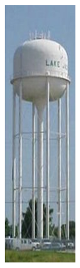
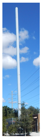
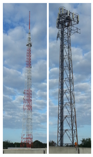
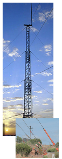
Table 4.B.9.B – Typical Examples of
Commercial Communication Towers
|
|
|
|
|
|
|
|
|

|
|
|
|
Communication towers
may be permitted on a lot with another principal use as provided herein unless
stated otherwise.
a. Owned
Parcel
Communication towers
may be located on lots containing another principal use, including another
communication tower.
b. Leased
Parcel
Towers may occupy a
leased parcel on a lot that meets the minimum lot size requirement of the zoning
district in which it is located. PBC may require execution of a Unity of Control,
or other documentation as determined appropriate by the County Attorney, for
leased parcels that do not meet the minimum lot size requirement for the zoning
district in which they are located.
c. Accessory
Structures
Any structure accessory
to communication towers, other than peripheral supports and guy anchors, shall
conform to the setback requirements for the zoning district in which it is
located.
Separation between
communication towers and other uses on the lot may be required to ensure
compatibility. Separation or setbacks for all towers shall be established, as
provided in Table 4.B.9.B, Minimum Separation and
Setbacks for Towers Located in Residential Zoning Districts, and Table 4.B.9.B, Minimum Separation and
Setbacks for Towers Located in Non-Residential Zoning Districts, unless stated otherwise herein.
a. Towers
Located in Residential Zoning Districts
|
Table 4.B.9.B – Minimum Separation and Setbacks
for Towers Located in Residential Zoning Districts
|
|
Tower Type
|
Adjacent to
|
|
|
|
|
|
|
|
|
|
|
|
|
Stealth Tower
≤
125’
|
Residential
Existing
|
150%
of tower height for separation between tower and adjacent residential
structures
100%
of tower height for setback from property line
|
|
Residential
Vacant
|
100%
of tower height for setback from property line
|
|
Non-Residential and
Public R-O-W
|
100%
of tower height for setback from property line
|
|
Stealth
Tower
> 125' to 200’ Max.
|
Residential
Existing
|
150%
of tower height for separation between tower and adjacent residential
structures
100%
of tower height for setback from property line
|
|
Residential
Vacant
|
100%
of tower height for setback from property line
|
|
Non-Residential and
Public R-O-W
|
20%
of tower height or zoning district setbacks whichever is greater
|
|
Camouflage Tower
150’ Max. (1)
|
Residential
Existing
|
150%
of tower height for separation between tower and adjacent residential
structures
100%
of tower height for setback from property line
|
|
Residential
Vacant
|
100%
of tower height for setback from property line
|
|
Non-Residential and
Public R-O-W
|
20%
of tower height or zoning district setbacks whichever is greater
|
|
Monopole Tower (2)
|
Residential
Existing
|
600%
of tower height for separation between tower and adjacent residential
structures
150%
of tower height for setback from property line
|
|
Residential
Vacant
|
150%
of tower height for setback from property line
|
|
Non-Residential and
Public R-O-W
|
20%
of tower height or zoning district setbacks whichever is greater
|
|
Self-Support/
Lattice Tower (2)
|
Residential
Existing
|
600%
of tower height for separation between tower and adjacent residential
structures
150%
of tower height setback from property line
|
|
Residential
Vacant
|
150%
of tower height setback from property line
|
|
Non-Residential and
Public R-O-W
|
20%
of tower height or zoning district setbacks whichever is greater
|
|
Guyed Tower (2)
|
Residential
Existing
|
Lesser
of 600% of tower height or 1,500’ separation between tower and adjacent
residential structures, and 150% of tower height for setback from property
line
|
|
Residential
Vacant
|
150%
of tower height for setback from property line
|
|
Non-Residential and
Public R-O-W
|
20%
of tower height or zoning district setbacks whichever is greater
|
|
FDOT
|
Height,
tower type, and setbacks limited as provided in this
Section
|
|
[Ord. 2017-016]
|
|
Notes:
|
|
1.
|
Maximum height subject to the specific requirements
contained in the Supplementary Use Standards.
|
|
2.
|
Applicable to any tower height.
|
|
|
|
|
|
|
|
|
|
|
|
|
|
|
|
Table 4.B.9.B
– Minimum Separation and Setbacks for Towers Located in Residential Zoning
Districts, Cont’d.
|
|
Tower Type
|
Adjacent to
|
|
|
|
|
|
|
|
|
|
|
|
|
|
|
Stealth (3)
|
Residential
Existing (1) or
Vacant (2)
|
|
|
Non-Residential
|
|
|
Full Array Urban
≤
80’ (3)
|
Residential
Existing (1) or
Vacant (2)
|
|
|
Non-Residential
|
|
|
Full Array Urban
> 80’ < 150’ (3)
|
Residential
Existing (1) or
Vacant (2)
|
|
|
Non-Residential and
Public R-O-W
|
|
|
Full Array Rural (3)
|
Residential
Existing (1) or
Vacant (2)
|
|
|
Non-Residential and
Public R-O-W
|
|
|
[Ord. 2017-016]
|
|
Notes:
|
|
1.
|
Maximum height subject to the specific requirements
contained in the Supplementary Use Standards.
|
|
2.
|
Applicable to any tower height.
|
|
3.
|
Exceptions to minimum setbacks or separations may be
allowed in accordance with Art. 4.B.9.D.1.f, Exceptions to
Separations and Setback Requirements.
|
|
|
|
|
|
|
|
|
|
|
|
|
|
|
b. Towers
Located in Non-Residential Zoning Districts
|
Table 4.B.9.B – Minimum Separation and Setbacks
for Towers Located in Non-Residential Zoning Districts
|
|
Tower Type
|
Adjacent to
|
|
|
|
|
|
|
|
|
|
|
|
|
|
|
|
|
|
|
Stealth Towers
200’ Max.
|
Residential
Existing (1)
|
150%
of tower height for separation, and 100% of tower height for setback from
property line
|
|
Residential
Vacant (2)
|
100%
of tower height for setback from property line
|
|
Non-Residential and
Public R-O-W
|
20%
of tower height or zoning district setbacks whichever is greater
|
|
Camouflage Towers
150’ Max. (1)
|
Residential
Existing (1)
|
150%
of tower height for separation, and 100% of tower height for setback from
property line
|
|
Residential
Vacant (2)
|
100%
of tower height for setback from property line
|
|
Non-Residential and
Public R-O-W
|
20%
of tower height or zoning district setbacks whichever is greater
|
|
Monopole Tower (2)
|
Residential
Existing (1)
|
600%
of tower height for separation, and 150% of tower height for setback from
property line
|
|
Residential
Vacant (2)
|
150%
of tower height for setback from property line
|
|
Non-Residential and
Public R-O-W
|
20%
of tower height or zoning district setbacks whichever is greater
|
|
Self-Support/
Lattice Tower (2)
|
Residential
Existing (1)
|
600%
of tower height for separation, and 150% of tower height for setback from
property line
|
|
Residential
Vacant (2)
|
150%
of tower height for setback from property line
|
|
Non-Residential and
Public R-O-W
|
Lesser
of 100% of tower height or zoning district setback substantiated by
breakpoint calculations
|
|
Guyed Tower (2)
|
Residential
Existing (1)
|
Lesser
of 600% of tower height or 1,500’ separation, and 150% of tower height for
setback from property line
|
|
Residential
Vacant (2)
|
150%
of tower height for setback from property line
|
|
Non-Residential and
Public R-O-W
|
Lesser
of 100% of tower height or zoning district setback substantiated by
breakpoint calculations
|
|
FDOT
|
Residential
|
150’
setback from abutting residential property line
|
|
Non-Residential
|
75’
setback from abutting non-residential property line
|
|
[Ord. 2017-016] [Ord. 2017-025] [Ord.
2021-023]
|
|
Notes:
|
|
1.
|
Maximum height subject to the specific requirements
contained in the Supplementary Use Standards.
|
|
2.
|
Applicable to any tower height.
|
|
%
|
Separation or setback as a percentage of tower
height.
|
|
|
|
|
|
|
|
|
|
|
|
|
|
|
|
|
|
|
|
|
|
Table 4.B.9.B
– Minimum Separation and Setbacks for Towers Located in Non-Residential
Zoning Districts, Cont’d.
|
|
Tower Type
|
Adjacent to
|
|
|
|
|
|
|
|
|
|
|
|
|
|
|
|
|
|
|
|
|
Stealth (3)
|
Residential
Existing (1) or
Vacant (2)
|
150%
of tower height for separation, and 100% of tower height for setback from
property line
|
|
Non-Residential
|
20%
of tower height or zoning district setback whichever is greater
|
|
Full Array Urban
≤ 80’ (3)
|
Residential
Existing (1) or
Vacant (2)
|
150%
of tower height for separation, and 100% of tower height for setback from
property line
|
|
Non-Residential
|
20%
of tower height or zoning district setback whichever is greater
|
|
Full Array Urban
≤ 80’ < 150’ (3)
|
Residential Existing (1) or
Vacant (2)
|
600%
of tower height for separation, and 100% of tower height for setback from
property line
|
|
Non-Residential
and
Public R-O-W
|
20%
of tower height or zoning district setback whichever is greater
|
|
Full Array Rural (3)
|
Residential
Existing (1) or
Vacant (2)
|
600%
of tower height for separation, and 150% of tower height for setback from
property line
|
|
Non-Residential
and
Public R-O-W
|
20%
of tower height or zoning district setback whichever is greater
|
|
[Ord. 2017-016] [Ord. 2021-023]
|
|
Notes:
|
|
1.
|
Maximum height subject to the specific requirements
contained in the Supplementary Use Standards.
|
|
2.
|
Applicable to any tower height.
|
|
3.
|
Exceptions to minimum setbacks or separations may be
allowed in accordance with Art. 4.B.9.D.1.f, Exceptions to
Separations and Setback Requirements.
|
|
%
|
Separation or setback as a percentage of tower
height.
|
|
|
|
|
|
|
|
|
|
|
|
|
|
|
|
|
|
|
|
|
Construction of any
lawful residential or non-residential structure within the required separation
distance shall not create a non-conforming use or structure when an existing
communication tower is established pursuant to the provisions in Art. 4.B.9.B.2, Separation and Setbacks.
a. Existing
Residential Use
Separations from
existing residential structures shall be measured from the wall of the closest
principal residential structure to the base of the tower.
|
Figure
4.B.9.B – Measurement of Separation
|
|
|
b. Vacant
Residential Parcel
Setbacks from vacant
residential parcels shall be measured from adjacent property lines to the base
of the tower.
|
Figure
4.B.9.B – Measurement of Setback
|
|
|
Towers shall be subject
to the following minimum distances between towers:
|
Table 4.B.9.B – Distance between Towers
|
|
Tower Type
|
|
|
|
|
|
|
|
|
|
|
|
Stealth
|
N/A
|
N/A
|
N/A
|
N/A
|
N/A
|
N/A
|
N/A
|
N/A
|
|
Camouflage
|
N/A
|
N/A
|
N/A
|
N/A
|
N/A
|
N/A
|
N/A
|
N/A
|
|
Monopole
|
|
≤ 60’ in Height
|
N/A
|
N/A
|
N/A
|
N/A
|
N/A
|
N/A
|
N/A
|
N/A
|
|
> 60’ ≤ 100’ in Height
|
500’
|
660’
|
500’
|
N/A
|
N/A
|
N/A
|
300’
|
N/A
|
|
> 100’ ≤ 150’ in Height
|
660’
|
660’
|
660’
|
N/A
|
N/A
|
N/A
|
600’
|
N/A
|
|
> 150’ ≤ 200’ in Height
|
1,320’
|
1,320’
|
1,320’
|
1,320’
|
660’
|
660’
|
660’
|
660’
|
|
> 200’ ≤ 250’ in Height
|
2,640’
|
2,640’
|
2,640’
|
2,640’
|
1,320’
|
1,320’
|
1,320’
|
1,320’
|
|
> 250’ in Height
|
3,960’
|
5,280’
|
5,280’
|
2,640’
|
1,320’
|
2,640’
|
2,640’
|
2,640’
|
|
Self-Support/Lattice
|
5,280’
|
Not
permitted
|
5,280’
|
1,320’
|
N/A
|
N/A
|
5,280’
|
5,280’
|
|
Guyed
|
5,280’
|
Not
permitted
|
5,280’
|
2,640’
|
N/A
|
N/A
|
5,280’
|
5,280’
|
|
[Ord. 2017-016] [Ord. 2017-025] [Ord.
2021-023]
|
a. Measurement
of Distance between Towers
The distance between an
existing and a proposed tower shall be measured at grade in a direct lineal
fashion between the closest points of the base of the existing and the base of
proposed towers.
|
Figure
4.B.9.B – Distance Between Existing and Proposed Towers
|
|
|
Separations between
towers located in different zoning districts shall be measured as follows:
1) Residential and Residential
The greater of the
distance between towers requirements shall apply between residentially zoned
parcels.
2) Residential and Non-Residential
The greater of the
distance between towers requirements shall apply between residentially and non-residentially
zoned parcels.
3) Non-Residential and Non-Residential
The lesser of the
distance between towers requirements shall apply between non-residentially
zoned parcels.
4) Certification of Distance
The distance between
towers shall be certified by a Professional Engineer or a Professional Surveyor
and Mapper, each of whom shall be licensed by the State of Florida.
All antennas and other
attachments shall be included in the height measurement of the tower structure,
and shall not extend beyond its maximum permitted height. Lightning rods and
whip antennas, less than six inches in diameter, shall be excluded from this
requirement.
Communication towers shall be exempt from the parking
requirements of Art.
6, Parking, Loading, and Circulation, unless otherwise required by the
Zoning Director.
a. Fence or Wall
A fence or wall, a minimum of eight feet in height measured from
finished grade, shall be constructed around the base of each communication
tower and accessory equipment structure, and around each guy anchor. Access to
the communication tower shall be through a locked gate.
b. Landscaping
The landscape and buffer standards provided below shall be
required around the perimeter of the tower, accessory structures, and guy
anchors, unless waived as provided herein. These standards may be waived by the
Zoning Director, unless otherwise required by the BCC or ZC when the proposed
landscaping would not be visible from adjacent lots or streets.
1) Installation
Landscaping shall be installed along the exterior side of any
required fences, unless the Zoning Director determines that the viability,
survivability, or utility of the plant material is enhanced when located along
the interior side of the fence or wall.
2) Leased Parcels
Landscaping shall be maintained pursuant to Art. 7, Landscaping. The Applicant
shall execute a perpetual maintenance agreement with the Property Owner to
ensure the maintenance of the landscape buffer if the buffer is installed
outside of the leased parcel footprint.
3) Adjacent to
Residential FLU Designation, Zoning District, or Use
a) Towers Less Than
50 feet from Existing Residential
A Type 3 Incompatibility Buffer without a wall shall be installed
between towers and adjacent lots with existing residential uses or FLU
designations, pursuant to Art. 7.C.2.C, Incompatibility
Buffer.
b) Towers More Than
50 feet from Existing Residential
A Type 1 Incompatibility Buffer shall be installed between
towers and adjacent lots with existing residential uses, residential zoning, or
residential FLU designations, pursuant to Art. 7.C.2.C, Incompatibility
Buffer.
4) Adjacent to Non-Residential
Uses or Zoning Districts
Towers shall comply with the standards for landscape buffers
between compatible uses of Art. 7.C.2.B,
Compatibility Buffer.
c. Accessory Equipment and
Structures
All accessory equipment and structures shall be located within
the required perimeter buffering.
a. Signs and Advertising
The placement on a Monopole, Self-Support/Lattice, or Guyed
Tower, of any signs, flags, or appurtenances for advertising purposes,
including company name, shall be prohibited. Signs or advertising may be
permitted when in conjunction with a Stealth Tower when that structure is an
integral element of a principal building or structure.
The least intensive
nighttime method of illumination acceptable to the FAA shall be utilized. To
the extent possible, strobe lighting or similar types of lighting shall not be
utilized. All required lighting shall be maintained on an as-needed basis by
the owner of the tower. [Ord. 2022-002]
a. As provided by the FCC, towers shall not
interfere with the normal operation of electrical or mechanical equipment
located within surrounding properties.
b. Towers or guy wires shall not impede the
aerial mosquito control activities performed by PBC, as determined by the BCC,
for the health, safety, and welfare of its residents.
In addition to the
approval processes required in Table 4.B.9.A, Commercial Communication
Towers Matrix, a Building Permit
shall be required for all towers, support and accessory structures, and antenna
attachments, except as otherwise provided by Federal, State of Florida, or Local
law.
a. Accessory
Structures
Building Permits shall
be required for all accessory structures related to an antenna.
b. Wind
Load Standards
All antennas and other
tower attachments shall meet the required wind load standards pursuant to
Building Division review. Documentation indicating compliance with the wind load
standards shall be certified by a Professional Engineer, licensed in the State
of Florida, and submitted to the Building Division at the time of Building
Permit application.
c. Airport
Regulations
Prior to the issuance
of a Building Permit for a tower, proof of compliance with applicable
requirements of Art. 16, Airport Regulations of the Code, shall be provided in a manner
acceptable to the Zoning Director.
All communication
towers, shall be constructed to accommodate a minimum number of providers as
follows:
|
Table 4.B.9.B
– Providers by Tower Type
|
|
Tower Types (1)
|
|
|
Stealth
|
2 providers
(2)
|
|
Camouflage
|
1 provider
for a max. 100’ height tower
|
|
2 providers
for a max. 125’ height tower
|
|
3 providers
for a max. 150’ height tower
|
|
Monopole, Self-Support/Lattice, and Guyed
|
2 providers
|
|
Notes:
|
|
1.
|
Prior to the issuance of a Building Permit for a
structure with two or more providers, the Applicant shall provide proof of
shared use/collocation in a form acceptable to the County Attorney and Zoning
Director.
|
|
2.
|
An Applicant may not be required to accommodate the
additional providers in the event the shared use/collocation review
procedures indicate no other service provider wishes to collocate on the
structure.
|
|
|
|
Antennas attached to
towers shall be subject to the standards contained in this Section. Standards
for antennas attached to other type of structure are addressed in Art. 5. Supplementary Standards.
All towers shall be
inspected in compliance as required by the Building Division.
The Property Owners, as
well as the tower owners, shall be responsible for violations of applicable
standards.
A structure, which is
not readily identifiable as a tower and is compatible with existing or proposed
uses on site. The structure may or may not have a secondary function.
b. Typical
Structures
Typical structures
include but are not limited to bell tower, steeple, flagpole, cross, or water
tank where antennas are typically concealed.
c. Approval
Process – AGR, AR, and RE Zoning Districts
In the AGR, AR/RSA,
AR/USA, and RE Zoning Districts, Stealth Towers 100 feet in height or less may
be approved through the DRO Agency review process when the parcel has an
existing DRO-approved Site Plan. Approval shall be subject to the
Administrative Modification standards contained in Art. 2, Application Processes and Procedures.
d. Approval
Process – Commercial and Civic Pod of PUD
In the Commercial Pod
and Civic Pod of a PUD, Stealth Towers 60 feet in height or less may be
approved by the DRO.
e. Location
– Recreation Pod of PUD
Stealth Towers may be
permitted in the Recreation Pod of a PUD only when located on a Golf Course
subject to Class A Conditional Use approval.
f. Lot
Size – MUPD
A Stealth Tower may
only be located in an MUPD with a CH or CL FLU designation with a minimum of
five acres, provided the tower complies with all applicable regulations.
g. Criteria
Stealth structures shall comply with the following criteria:
1) The structure
shall be compatible with the architectural style of the existing
buildings/structures on site and with the character of the surrounding area. A
determination of architectural compatibility shall include, but not be limited
to, color, type of building material, and architectural style;
2) The structure
shall be consistent with the character of existing uses on site;
3) Communications
equipment or devices shall not be readily identifiable;
4) The structure
shall be related to and integrated into the existing natural and/or man-made
environment to the greatest extent possible; and,
5) The maximum
height of the structure shall not exceed 200 feet.
h. Associated Uses in RT, RS, RM
Zoning Districts, and Commercial or Civic Pod of a PUD
Stealth Towers shall be permitted only in association with the
following uses: Assembly Institutional Nonprofit; Place of Worship; College or
University; Electric Power Plant, excluding Electrical Transmission Line
streets as provided herein; Government Services; Passive Park; Public Park;
Golf Course; Schools; Solid Waste Transfer Station; Minor Utility; Electric
Distribution Substations; Water or Wastewater Treatment Plant; or, commercial,
office, or industrial development.
i. Flagpoles
Stealth Towers in the form of flagpoles shall be exempt from Art. 8.G.3.C, Flags
and Freestanding Flagpoles.
The minimum separation between any existing residential
structure, and Stealth Towers located in Public Parks five acres or greater
shall be 125 percent of tower height. In addition, the tower shall be set back
a distance of at least 75 percent of tower height from any property line
adjacent to an existing residential use or vacant residential parcel or 20
percent of the tower height from any adjacent non-residential zoning district
or public R-O-W.
A tower or structure,
which is incorporated into and is compatible with existing or proposed uses on
site and the structure has an additional function other than antenna support.
b. Typical
Structures
Examples include but
are not limited to antenna incorporated into site lighting at a park or
incorporated into an electrical distribution center.
c. Location
– Recreation Pod of PUD
Camouflage Towers may be
permitted in the Recreation Pod of a PUD only when located on a Golf Course
subject to Class A Conditional Use approval.
d. Approval
Process – Commercial and Civic Pod of PUD
In the Commercial Pod
and Civic Pod of a PUD, Camouflage Towers 60 feet in height or less may be
approved by the DRO.
e. Lot
Size – MUPD
A Camouflage Tower may
only be located in an MUPD with a CH or CL FLU designation with a minimum of
five acres, provided the tower complies with all applicable regulations.
f. Associated Uses in RT, RS, RM
Zoning Districts, and Commercial or Civic Pod of a PUD
Camouflage Towers shall be permitted
only in association with the following uses: Assembly Institutional Nonprofit;
Place of Worship; College or University; Electric Power Plant, excluding Electrical
Transmission Line streets as provided herein; Government Services; Passive
Park; Public Park; Golf Course; Schools; Solid Waste Transfer Station; Minor
Utility; Electric Distribution Substations; Water or Wastewater Treatment
Plant; or, commercial, office, or industrial development.
Applications for approval to install a Camouflage Tower shall
include the following information:
1) A colorized
illustration or representation of the proposed tower.
2) The height,
diameter, and coloration of the proposed facility.
3) A statement of
compatibility to indicate the nature and character of the surrounding area, and
how the proposed facility will be consistent with the overall characteristics
of the area.
The minimum separation between any existing residential
structure, and Camouflage Towers located in Public Parks five acres or greater
shall be 125 percent of tower height. In addition, the tower shall be set back
a distance of at least 75 percent of tower height from any property line
adjacent to an existing residential use or vacant residential parcel or 20
percent of the tower height from any adjacent non-residential zoning district
or public R-O-W.
A structure that
consists of a single pole supported by a permanent foundation.
b. Lot
Size – MUPD
A Monopole Tower may
only be located in an MUPD with a CH or CL FLU designation with a minimum of
five acres, provided the tower complies with all applicable regulations.
c. Increase
in Height
The height of a Monopole Tower may be increased as provided
herein.
1) Percentage of
Increase
The height of a proposed Monopole Tower may be increased by 20
percent, one time only, without regard to required separation or setback
requirements, for all applications which provide proof of the collocation of an
additional personal wireless service provider. Additional increases are subject
to setbacks and separations of this Code.
2) Proof of
Collocation
Proof of collocation shall be provided in a form acceptable to
the County Attorney and the Zoning Director. Proof of collocation shall include
an executed contract or lease providing for use of the facility for a period of
at least ten years.
A structure that is
constructed without guy wires or ground anchors.
A structure that is
supported either partially or completely by guy wires and ground anchors.
b. Lot
Size – MUPD
A Guyed Tower may only
be located in an MUPD with a CH or CL FLU designation with a minimum of five
acres, provided the tower complies with all applicable regulations.
c. Setbacks
Breakpoint calculations may be provided to demonstrate a tower
will collapse within the minimum required zoning district setbacks. Breakpoint
calculations shall be certified by a Professional Engineer, licensed in the
State of Florida.
Peripheral supports and guy anchors may be located within
required setbacks provided they shall be located entirely within the boundaries
of the property on which the communication tower is located. Peripheral
supports and guy anchors shall be located at least ten feet from all property
lines.
1. Electrical Transmission
Lines and Substations
Antennas and other
wireless equipment may be attached to existing or modified Transmission Poles
or utility structures within an Electric Distribution Substation or Electric
Transmission Substation, subject to the following: [Ord. 2017-016]
a. Stealth
Electrical Communication Structures and Poles
1) Definition
A Transmission Pole, or
structure within an Electric Distribution Substation or Electric Transmission
Substation, supporting collocated wireless attachments, which is not readily
identifiable as a tower. Stealth structures are limited to canister-type
antenna design. [Ord. 2017-016]
b. Full
Array Electrical Communication Structures and Poles
1) Definition
A Transmission Pole, or
structure within an Electric Distribution Substation or Electric Transmission
Substation, supporting collocated wireless attachments, which are visible and
readily identifiable as a Commercial Communication Tower. [Ord. 2017-016]
c. Typical
Structures
Typical structures
include Transmission Poles within utility transmission corridors or
substations, or other similar electrical transmission infrastructure located
within substations such as lighting masts or back-up transformer connection
poles. [Ord. 2017-016]
|
Figure
4.B.9.D – Typical Examples of Electrical Transmission Poles or Utility
Structures
|
|
|
|
[Ord. 2017-016]
|
d. Modifications
to Transmission Poles or Utility Structures
Height increases to
Transmission Poles and other Substation structures may be allowed to
accommodate antenna attachments. Modified replacement poles or utility
structures may be permitted to the extent required to meet structural or
Building Code requirements due to increased wind load from height increases or
attachments, provided that modifications generally appear to be of a similar
dimensions and appearance to existing or adjacent poles or structures. [Ord. 2017-016]
1) Application Requirements
Applications for
Stealth or Full Array Electrical Transmission Poles or Utility Structures shall
include a detailed analysis and supporting documentation establishing the
original dimensions, including height or any other structural characteristics
that the proposed modifications are based on. [Ord. 2017-016]
2) Determination of Original Pole or Structure
Dimensions
The final determination
of the original dimensions specified in an application shall be decided by the
DRO in consultation with the Building Official, or the Building Official where
Permitted by Right. [Ord. 2017-016]
e. Approval
Process
Exceptions to the
approval processes for modification to Electrical Transmission Poles or Utility
Structures specified in Table 4.B.9.A, Commercial Communication
Towers Matrix, Stealth
Transmission Poles or Utility Structures, may be allowed as follows: [Ord. 2017-016]
1) Stealth
a) Subject to DRO Approval
May be Permitted by
Right provided the increase in height is either: [Ord. 2017-016]
(1) less than 35 percent; or [Ord. 2017-016]
(2) 50 percent and the tower is located a minimum
of 2,500 feet from a public street or parcel with a residential FLU designation
or use. [Ord. 2017-016]
b) Subject to Class A or Class B Conditional Use
Approval
May be allowed subject
to DRO approval provided the increase in height is either:
(1) less than 35 percent; or [Ord. 2017-016]
(2) 50 percent and the tower is located a minimum
of 2,500 feet from a public street or parcel with a residential FLU designation
or use. [Ord. 2017-016]
2) Full Array Urban
a) Subject to DRO Approval
May be Permitted by
Right where allowed in agricultural, commercial, industrial, or institutional zoning
districts, provided the increase in height is: [Ord. 2017-016]
(1) less than 35 percent; and [Ord. 2017-016]
(2) the tower is located a minimum of 2,500 feet
from a public street or any parcel with a residential FLU designation or use. [Ord. 2017-016]
b) Subject to Class A or Class B Conditional Use
Approval
May be allowed subject
to DRO approval, where allowed in agricultural, commercial, industrial, or institutional
zoning districts, provided the increase in height is either: [Ord. 2017-016]
(1) less than 35 percent; or [Ord. 2017-016]
(2) 50 percent and the tower is located a minimum
of 2,500 feet from any public street, or parcel with a residential FLU
designation or use. [Ord. 2017-016]
c) Residential Districts Including Residential
Pod of PUD
May be allowed to be
collocated within an Electric Distribution Substation or Electric Transmission
Substation subject to Class A Conditional Use approval. [Ord. 2017-016]
3) Full Array Rural
a) Subject to DRO Approval
May be Permitted by
Right where allowed in agricultural, commercial, industrial, or institutional zoning
districts, subject to the following: [Ord. 2017-016]
(1) the increase in height is less than 50 percent;
[Ord. 2017-016]
(2) located a minimum of: [Ord. 2017-016]
(a) 2,500
feet from any public street; [Ord. 2017-016]
(b) one
mile from any Arterial or Collector; and, [Ord. 2017-016]
(c) parcel
with a residential FLU designation or use. [Ord. 2017-016]
b) Subject to Class A or Class B Conditional Use
Approval
May be allowed subject
to DRO approval, where allowed in agricultural, commercial, industrial, or institutional
zoning districts, provided the increase in height is less than 50 percent, and
the tower is located a minimum of 2,500 feet from any public street, and one mile
from any Arterial or Collector or parcel with a residential FLU designation or use.
[Ord. 2017-016]
The following
exceptions may be allowed from the minimum separation or setbacks established
in Art. 4.B.9.B.2, Separation and Setbacks: [Ord.
2017-016]
1) General Exceptions
a) Stealth
Modifications to
Stealth Transmission Poles or Electric Distribution Substation or Electric Transmission
Substation utility structures that do not exceed 35 percent of the height of
the original pole or structure. [Ord. 2017-016]
b) R-O-W with Collocated Minor Utility on
Adjacent Parcel
Setbacks from adjacent
parcels that are included in the Development Order for the purposes of
providing for a supporting collocated Minor Utility (excluding separations from
residential or occupied buildings). [Ord. 2017-016]
c) Adjacent Properties with Bona Fide
Agriculture Uses
Parcels with an agricultural
FLU designation and zoning district, supporting Bona Fide Agriculture, provided
that separation distances from occupied structures are a minimum of 150 percent
of the tower height. [Ord. 2017-016]
2) Towers Located on Residential Parcels
Measurement may exclude
open space areas designated on an approved plan for non-residential uses such
as water management tracts or landscape buffers, but excluding any common areas
located within 50 feet of a recreation amenity or public or civic use such as Day
Cares, Schools, or Places of Assembly, including any outdoor recreation areas. [Ord. 2017-016]
g. Other
Attachments or Structures
Additional wireless
support attachments or structures other than that permitted at the top of the
structure or pole, may be allowed subject to the following: [Ord. 2017-016]
1) Transmission Corridors
a) Attachments
Attachments must be
concealed within the pole or structure. External attachments such as,
electrical or mechanical boxes or backpacks, excluding a utility meter,
electrical cabling, platforms, or other similar modifications shall be
prohibited, unless allowed otherwise herein. [Ord. 2017-016]
b) Equipment Boxes
Equipment boxes may be
allowed within an Arterial or Plan Collector Street, subject to approval by the
County Engineer. [Ord. 2017-016]
c) Equipment Shelters
Equipment shelters
supporting collocated cellular equipment placed on Electrical Transmission
Lines, may be allowed to be located on an adjacent parcel, subject to
compliance with the following: [Ord. 2017-016]
(1) Minor Utility
May be allowed in
accordance with the districts, approval process, and any other development
standards for a Minor Utility. [Ord.
2017-016]
(2) Developed Parcels
Where a Minor Utility
is collocated with another use, the Minor Utility shall be prohibited within
the front or side street yard, unless abutting a perimeter buffer. In either
scenario, the Minor Utility shall not adversely impact interior site design or
function, including but not limited to: pedestrian or vehicular circulation,
landscaping, or commonly recognized CPTED standards. [Ord. 2017-016]
h. FDO
Requirements
Prior to the issuance
of a Building Permit, the Applicant shall supply a letter from FDO
demonstrating no anticipated impact to the usual and customary transmission or
reception operability of public safety communication systems. This letter shall
be based upon information supplied to FDO by the Applicant identifying the
latitudinal and longitudinal coordinates of the proposed wireless communication
equipment, the proposed RF spectrum of operations, and any further technical
information deemed necessary by FDO in order to render a technical conclusion. Any
costs incurred by FDO for an independent third party to provide technical
assistance in rendering a conclusion, as determined by FDO in its sole and
absolute discretion and authorized in advance by the Applicant, shall be the
responsibility of the Applicant regardless of permit issuance, failure to
obtain a permit, or withdrawal. [Ord.
2017-016]
Within the streets for
I-95 and Florida’s Turnpike owned or controlled by the FDOT, towers, or
antennas are subject to the following:
a. Installation
of Antennas
Antennas may be
attached to existing communication towers, light standards, or other structures
or facilities subject only to Building Permit review.
b. Construction
of New Towers
New towers constructed
within streets shall comply with the following requirements:
1) Towers installed in those portions of streets
immediately adjacent to any property possessing a residential designation shall
be:
a) Located in a street at least 250 feet in
width;
b) Only a Monopole or Self-Support/Lattice Tower;
c) No more than 150 feet in height;
d) Set back a minimum of 150 feet from the
nearest property line; and,
e) Require review as provided in Table 4.B.9.A, Commercial Communication
Towers Matrix.
2) Towers installed in those portions of streets
immediately adjacent to any property possessing a non-residential designation
shall be:
a) Located in a street at least 200 feet in
width;
b) Only a Monopole or Self-Support/Lattice Tower;
c) No more than 200 feet in height;
d) Set back a minimum of 75 feet from the
nearest non-residential property line and 150 feet from any residential
property line; and,
e) Require review as provided in Art. 4.B.9.A, Commercial Communication
Towers Matrix.
c. Separation
of New Towers
New towers shall be
subject to the separation distances as provided in Table 4.B.9.B, Distance between Towers.
This Subsection
implements Subsection 6409(a) of the Middle Class Tax
Relief and Job Creation Act of 2012 (“Spectrum Act”), as interpreted by the Federal
Communications Commission’s (“FCC” or “Commission”) Acceleration of Broadband
Deployment Report & Order, which requires a State or local government to
approve any eligible facilities request for a modification of an existing tower
or base station that does not result in a substantial change to the physical
dimensions of such tower or base station.
For the purposes of
this Subsection, the terms used have the following meaning:
a. Base
Station
A structure or
equipment at a fixed location that enables FCC-licensed or authorized wireless
communications between user equipment and a communications network. The term
does not encompass a tower as defined herein or any equipment associated with a
tower. Base station includes, without limitation:
1) Equipment associated with
wireless communications services such as private, broadcast, and public safety
services.
2) Radio transceivers, antennas,
coaxial or fiber-optic cable, regular and back-up power supplies, and
comparable equipment, regardless of technological configuration (including
Distributed Antenna Systems (“DAS”) and small-cell networks).
3) Any structure other than a tower that, at the
time the relevant application is filed under this Subsection, supports or
houses equipment described in Art. 4.B.9.E.1.a.1) and Art. 4.B.9.E.1.a.2) that has been reviewed and approved under
the applicable Zoning process, or under another State or Local regulatory
review process, even if the structure was not built for the sole or primary
purpose of providing that support.
The term “base station”
does not include any structure that, at the time the relevant application is
filed under this Subsection, does not support or house equipment described in Art. 4.B.9.E.1.a.1) and Art. 4.B.9.E.1.a.2) of this Subsection.
b. Collocation
The mounting or
installation of transmission equipment on an eligible support structure for the
purpose of transmitting and/or receiving radio frequency signals for
communications purposes.
c. Eligible
Facilities Request
Any request for
modification of an existing tower or base station that does not substantially
change the physical dimensions of such tower or base station, involving:
1) Collocation of new transmission equipment;
2) Removal of transmission equipment; or,
3) Replacement of transmission equipment.
d. Eligible
Support Structure
Any tower or base
station as defined in this Subsection, provided that it is existing at the time
the relevant application is filed under this Subsection.
e. Existing
A constructed tower or
base station is existing for purposes of this Subsection if it has been
reviewed and approved under the applicable Zoning process, or under another State
or Local regulatory review process, provided that a tower that has not been
reviewed and approved because it was not subject to a Zoning review process
when it was built, but was lawfully constructed, is existing for purposes of
this Subsection.
f. Site
For towers other than
towers in the public rights-of-way, the current boundaries of the leased or
owned property surrounding the tower and any access or utility easements
currently related to the site, and, for other eligible support structures,
further restricted to that area in proximity to the structure and to other
transmission equipment already deployed on the ground.
g. Substantial
Change
A modification
substantially changes the physical dimensions of an eligible support structure
if it meets any of the following criteria:
1) For towers other than towers
in the public rights-of-way, it increases the height of the tower by more than ten
percent or by the height of one additional antenna array with separation from
the nearest existing antenna not to exceed 20 feet, whichever is greater; for
other eligible support structures, it increases the height of the structure by
more than ten percent or more than ten feet, whichever is greater;
2) For towers other than towers in the public
rights-of-way, it involves adding an appurtenance to the body of the tower that
would protrude from the edge of the tower more than 20 feet, or more than the
width of the tower structure at the level of the appurtenance, whichever is
greater; for other eligible support structures, it involves adding an
appurtenance to the body of the structure that would protrude from the edge of
the structure by more than six feet;
3) For any eligible support structure, it
involves installation of more than the standard number of new equipment
cabinets for the technology involved, but not to exceed four cabinets; or for
towers in the public rights-of-way and base stations, it involves installation
of any new equipment cabinets on the ground if there are no preexisting ground
cabinets associated with the structure, or else involves installation of ground
cabinets that are more than ten percent larger in height or overall volume than
any other ground cabinets associated with the structure;
4) It entails any excavation or
deployment outside the current site;
5) It would defeat the concealment elements of
the eligible support structure; or,
6) It does not comply with conditions associated
with the siting approval of the construction or modification of the eligible
support structure or base station equipment; provided, however, that this
limitation does not apply to any modification that is non-compliant only in a
manner that would not exceed the thresholds identified in Art. 4.B.9.E.1.g.1) through Art. 4.B.9.E.1.g.4) of this Subsection.
h. Transmission
Equipment
Equipment that
facilitates transmission for any FCC-licensed or authorized wireless
communication service, including, but not limited to, radio transceivers,
antennas, coaxial or fiber-optic cable, and regular and back-up power supply.
The term includes equipment associated with wireless communications services
including, but not limited to, private, broadcast, and public safety services.
i. Tower
Any structure built for
the sole or primary purpose of supporting any FCC-licensed or authorized
antennas and their associated facilities, including structures that are
constructed for wireless communications services including, but not limited to,
private, broadcast, and public safety services.
Notwithstanding any
other provisions in this Section to the contrary, eligible facilities requests
for a modification of an existing tower or base station that does not result in
a substantial change to the physical dimensions of such tower or base station
as determined by the process set forth herein, shall be subject to Building
Permit review only.
a. Application
Requirements
Applications shall include
all information necessary to determine whether the modification of the existing
tower or base station does not substantially change its physical dimensions.
b. Timeframe
for Review
Within 60 days of the
date on which an Applicant submits an application, the Zoning Division shall
approve the application unless it determines that the application is not
covered by this Subsection.
c. Tolling
of the Timeframe for Review
The 60-day review
period begins to run when the application is filed, and may be tolled only by
mutual agreement by the Zoning Division and the Applicant, or in cases where
the Zoning Division determines that the application is incomplete. The
timeframe for review is not tolled by a moratorium on the review of
applications.
1) To toll the timeframe for incompleteness, the
Zoning Division must provide written notice to the Applicant within 30 days of
receipt of the application, specifically delineating all missing documents or
information required.
2) The timeframe for review begins running again
when the Applicant makes a supplemental submission in response to the notice of
incompleteness.
3) Following a supplemental submission, the Applicant
will be notified within ten days that the supplemental submission did not
provide the information identified in the original notice delineating missing
information. The timeframe is tolled in the case of second or subsequent
notices. Second or subsequent notices of incompleteness may not specify missing
documents or information that was not delineated in the original notice of
incompleteness.
d. Failure
to Act
In the event the Zoning
Division fails to approve or deny a request seeking approval under this Subsection
within the timeframe for review (accounting for any tolling), the request shall
be deemed granted, and the Applicant may proceed directly to Building Permit review.
The deemed grant does not become effective until the Applicant notifies the
applicable reviewing authority in writing after the review period has expired
(accounting for any tolling) that the application has been deemed granted.
Prior to submittal of
an application for approval of a proposed tower for Conditional Use,
Development Order Amendment, DRO, or Building Permit review, all Applicants
shall comply with the procedures indicated below. [Ord. 2021-006]
All communication tower
Applicants shall provide a Notice by certified mail to all users on the
Communication Tower Users List. The Notice shall invite potential communication
tower users to apply, to the Applicant, for space on the proposed tower to
encourage collocation. A copy of the Notice shall be mailed to the Electronic
Services and Security and the Zoning Divisions. The Notice mailing date shall
be within one year prior to submitting the Zoning application. The following
information shall be included in the Notice: [Ord. 2021-006]
a. description of the proposed tower; [Ord. 2021-006]
b. general location; [Ord. 2021-006]
c. longitude and latitude; [Ord. 2021-006]
d. identify any pre-reserved space on the tower
and upon the land area itself; [Ord.
2021-006]
e. provide any lease provisions being made
available: such as equipment shelter space, space for third-party equipment
shelter, and provisions of back-up power; [Ord.
2021-006]
f. general rate structure for leasing space,
which shall be based on reasonable local charges; [Ord. 2021-006]
g. proposed tower height; [Ord. 2021-006]
h. a phone number to locate the Applicant or Agent
for the communication tower; and, [Ord.
2021-006]
i. an Applicant’s Collocation Application. [Ord. 2021-006]
Potential communication
tower users shall respond to the Applicant’s Notice within 20 days of receipt
of certified mailing. Responses shall be submitted utilizing the Applicant’s
Collocation Application. A completed Collocation Application shall be sent to
the owner of the proposed communication tower or authorized Agent. The tower Applicant
shall not be responsible for a lack of response or responses received after the
20-day period. The Applicant shall provide the responses to the Collocation
Application as part of the Zoning application request for the new tower. [Ord.
2021-006]
The feasibility of each
collocation use request shall be evaluated by the Applicant. The evaluation
shall document the feasibility of collocation on the proposed communication
tower owner and a potential lessee or sharer. Factors to be considered when
evaluating the feasibility of collocation include but are not limited to:
structural capacity; RF interference; geographic service area requirements; mechanical
or electrical incompatibilities; inability or ability to locate equipment on
approved and unbuilt communication towers; cost (if fees and costs for sharing
would exceed the cost of the new communication tower amortized over a 25-year
period); FCC limitations that would preclude collocation; and, other applicable
Code requirements. [Ord. 2021-006]
If the Applicant
rejects one or more request(s) for collocation and if potential tower lessees
dispute the rejection(s) for collocation, the following procedure shall occur
within ten working days after the collocation response deadline. [Ord.
2021-006]
a. Submittal
The Applicant shall
submit two copies of the following to the Zoning Division: the Collocation
Applications submitted by potential users; a brief evaluation of each rejected
response; all design data for the proposed communication tower; and, an
explanation indicating the structural improvements necessary to facilitate the
requests that are rejected due to structural limitations, paid for by the tower
space lessee. [Ord. 2021-006]
b. Consultant
The Zoning Division
shall forward copies of all applications for collocation and the Applicant's
evaluation of each rejected request to a qualified communications consultant.
The consultant shall be selected by and retained at the discretion of the
Zoning Division and paid by Applicant who is refusing to allow collocation from
an interested service provider. [Ord.
2021-006]
c. Evaluation
Within ten working days
of receiving the collocation responses that were rejected by the Applicant and
disputed by the potential tower space lessee, the consultant shall review and
prepare an evaluation. Two copies of the consultant's evaluations shall be sent
to the Zoning Division. One copy of the evaluation shall be made an official
part of the communication tower application and one copy of the evaluation
shall be forwarded to the Applicant by the Zoning Division. The consultant's
report shall be advisory, and made part of the Staff Report, and considered in
reviewing the communication tower application. [Ord. 2021-006]
If the Applicant did
not reject any requests for collocation or if rejected requests for tower space
are not disputed by any potential tower lessee(s), consultant review is not
necessary. [Ord. 2021-006]
a. Form
of Agreement
All obsolete or
abandoned communication towers shall be removed within three months following
cessation of use. Prior to the issuance of a Building Permit or Site Plan
approval, whichever occurs first, the Property Owners or tower operators shall
submit an executed removal agreement to ensure compliance with this
requirement. The removal agreement shall be in a form acceptable to the County
Attorney.
b. Surety
for Removal
Prior to the issuance
of a Building Permit, surety shall be submitted by the Property Owner or tower
operator to ensure the removal of abandoned communication towers. The form of
surety shall be subject to approval by the Executive Director of PZB and the
County Attorney. The required surety shall be irrevocable, unless released by
the BCC. The surety shall be utilized to cover the cost of removal and disposal
of abandoned towers and shall consist of the following:
1) submittal of an estimate from a certified
structural engineer indicating the cost to remove and dispose of the tower;
2) a surety equivalent to 50 percent of the
estimated cost to remove and dispose of the tower;
3) an agreement to pool multiple sureties of the
tower owner or Property Owner to allow pooled surety to be used to remove
abandoned towers; and,
4) an agreement by the tower owner or Property
Owner to replenish surety pool upon utilization of surety by PBC.
c. Alternative
Surety for Removal
The Zoning Director,
subject to review by the County Attorney, may accept documentation from a tower
owner that adequate resources or irrevocable contractual obligations are
available to remove obsolete or abandoned communication towers.
d. Form
of Surety
Surety shall be
provided in a form consistent with the requirements of Art. 11.B.2.A.6.c, Performance or Surety
Bond.
e. Surety
Required
Surety required shall
be provided only for towers constructed after the effective date of this Code.
The following tower
hierarchy shall be used to determining impact:
LEAST IMPACT
Camouflage
Stealth
Monopole
Self-Support/Lattice
Guyed
MOST IMPACT
a. Conforming
Towers
An existing conforming
tower may be replaced subject to the criteria below. If the criteria are not
met, the replacement tower shall comply with the requirements of Art. 4.B.9.G.3, Tower Height Increases and Art. 4.B.9.G.4, Accessory Structures, below.
1) The tower shall accommodate a minimum of two providers.
2) The tower shall be of the same or lesser
impact than the existing structure pursuant to the tower hierarchy.
3) The tower may be required to be relocated on
site to lessen the impact on adjacent parcels.
4) The tower shall be subject to review by the
Zoning Division through the DRO, Art. 2.C.5.C, Administrative Modifications
to Prior DOs, Administrative
Amendment process.
5) The tower may be structurally modified to
allow collocation.
b. Non-Conforming
Towers
An existing non-conforming
tower may be replaced subject to the criteria below. If the criteria are not
met, the replacement shall comply with the requirements of Art. 4.B.9.G.3, Tower Height Increases and Art. 4.B.9.G.4, Accessory Structures, below.
1) The tower shall accommodate a minimum of two
providers.
2) The tower shall be of equal or less impact
than the existing structure pursuant to the tower hierarchy.
3) The tower may be required to be relocated on
site to lessen the impact on adjacent parcels.
4) The tower shall be subject to review by the
DRO.
5) The tower may be structurally modified to
allow collocation.
a. Conforming
and Non-Conforming Towers
Unless otherwise
provided herein, the height of a conforming or non-conforming tower may be
increased on one occasion subject to the requirements of Table 4.B.9.G, Tower Height Increases.
|
Table 4.B.9.G – Tower Height Increases
|
|
Review Process
|
|
|
|
Development Review Officer Administrative
Amendment
|
X (1)
|
N/A
|
|
Development Review Officer
|
X (2)
|
X (1)
|
|
Class B Conditional Use
|
X (3)
|
X (2)
|
|
Class A Conditional Use
|
X (4)
|
X
(3)(4)
|
|
Notes:
|
|
1.
|
Increases of 25 feet or less.
|
|
2.
|
Increases greater than 25 feet and 45 feet or less.
|
|
3.
|
Increases greater than 45 feet and 65 feet or less.
|
|
4.
|
Increases greater than 65 feet.
|
|
|
|
|
b. Monopoles
Unless otherwise
provided herein, the height of an existing Monopole Tower may be increased, on
one occasion, by a maximum of 20 percent to accommodate a second user subject
to standard Building Permit review. An additional increase of up to 20 percent
may be approved to accommodate an additional user, subject to standard Building
Permit review. Increases shall be based upon the original approved tower height.
c. Setbacks
If it is determined
that the proposed tower cannot meet setback requirements due to increases in
tower height to accommodate the collocation of at least one additional service
provider, minimum setback requirements may be reduced by a maximum of 15 feet,
except from residential property lines.
The size of an
accessory structure or structures may be increased to accommodate collocation.
The expansion shall be subject to Zoning Division review through the DRO
Administrative Amendment process.
The PZB Executive
Director may waive the review timeframes in the event of a declared State of Emergency.
If the regulations in this
Section prohibit a Government-Owned Tower from being located at a specific site
and the tower is required to protect the public health, safety, or welfare, the
applicable criteria may be waived or modified by the BCC. In such cases the BCC
shall make a finding of fact justifying the modification.
Towers located on School
sites and utilized for educational purposes only pursuant to F.S. § 1013.18 shall not be considered Commercial Communication
Towers.
Guyed Towers existing as of December 31, 1997 with a principal
use as a television broadcasting tower shall be exempt from the provisions of
this Section as provided below.
Television towers as provided herein shall be exempt from the
separation and setback distances of Table
4.B.9.B, Minimum Separation and Setbacks for Towers Located in Residential
Zoning Districts, and Table
4.B.9.B, Minimum Separation and Setbacks for Towers Located in Non-Residential
Zoning Districts.
Television towers as provided herein shall be exempt from the
distance between tower requirements of Table 4.B.9.B,
Distance between Towers.
Existing or replacement television towers as provided herein
shall be exempt from the Visual Impact Analysis requirements of Art. 4.B.9.I.4,
Visual Impact Analysis Standards.
Television towers exempted by the operation of this Subsection
may be replaced or reconstructed on the same parcel as provided below.
1) Approval
Television towers to be replaced or reconstructed shall be
reviewed as provided in Table 4.B.9.A,
Commercial Communication Towers Matrix.
2) Tower Height
The height of a replacement for or reconstruction of an existing
tower may be increased subject to approval as provided in Table 4.B.9.A,
Commercial Communication Towers Matrix.
3) Required
Setbacks from Property Lines
Setbacks from property lines shall be provided as indicated
below.
a) Structures of
Equal or Lesser Height
Television towers to be replaced or reconstructed with a
structure of equal or lesser height shall provide a setback substantially the
same as the existing setbacks, taking into account the continued location of
the tower being replaced during construction.
b) Structures of
Greater Height
Television towers to be replaced or reconstructed with a
structure of greater height shall provide a minimum setback of 110 percent of
tower height from any adjacent street and a minimum setback of 100 percent of
tower height from all adjacent property lines.
c) Breakpoint
Calculations
All setbacks shall be substantiated by certified breakpoint
calculations. The breakpoint calculations shall demonstrate that should tower
failure occur the entire height of the tower shall fall within with property
lines of the tower site.
d) Non-Conformity
Not Created
Replacement or reconstruction of a television broadcast tower
shall not result in creation of a non-conforming structure or non-conforming
use. The television broadcast tower resulting from the replacement or
reconstruction as provided herein shall be deemed a conforming structure and
use.
A Type 2 Waiver from the separation, setback, distance between
towers, height, and similar dimensional criteria applicable to communication
towers may be allowed.
The dimensional criteria may be reduced by the BCC for Class A
Conditional Uses and Class B Conditional Uses subject to the criteria contained
herein.
The dimensional criteria may be reduced by the BCC for towers
subject to review by the DRO or the Building Permit process subject to the
criteria contained herein.
When considering a request to allow a Type 2 Waiver from one or
more required dimensional criteria, the BCC must determine that: the request
complies with the intent of this Section; and the request is consistent with
the criteria listed below.
The following criteria shall be utilized by the BCC when
considering requests for Waivers. Each request for a Waiver must be consistent
with the following criteria listed below: Art. 4.B.9.H.5.d.1)
through Art.
4.B.9.H.5.d.8). In addition, each request for a Type 2 Waiver must be
consistent with one or more of the following criteria: Art.
4.B.9.H.5.d.9) though Art.
4.B.9.H.5.d.18).
1) Protection of Public Welfare
The Waiver, if approved, will not be injurious to the uses in
the area adjacent to the structure and otherwise will not be detrimental to the
public welfare.
2) Economics
The Waiver is not granted based solely upon or in large measure
due to costs associated with complying with all requirements contained herein.
3) Incompatibility
Not Created
The Waiver, if granted, will not result in an incompatibility
between the proposed tower or communication facility and adjacent uses.
4) Exhaustion of
Other Remedies
The Waiver, subject to documentation provided by the Applicant,
is necessary within the defined search or propagation study area as all other Waiver
alternatives have been exhausted. Alternatives to a Waiver shall include but not
be limited to such techniques as collocation, use of stealth or camouflage
structures, and use of building-mounted equipment and facilities.
5) Minimum Waiver
The grant of the Waiver is the minimum Waiver that will make
possible the reasonable use of the parcel of land, building, or structure.
6) Consistent with
the Plan
The grant of the Waiver will be consistent with the purposes, Goals,
Objectives, and Policies of the Plan and this Code.
7) Not Detrimental
The grant of the Waiver will not be injurious to the area
involved or otherwise detrimental to the public welfare.
8) Prohibition of Service
The Waiver, subject to documentation provided by the Applicant,
is necessary within the defined search or propagation study area so as not to
prohibit the provision of personal wireless, television, and related
communication services as defined by the Telecommunications Act of 1996 and
rules of the FCC, if adopted.
9) FAA Limitations
The Waiver is required to comply with locational standards
established by the FAA.
10) Lack of Technical
Capacity
The Waiver, subject to documentation provided by the Applicant,
is necessary within the defined search or propagation study area as existing
towers or other structures do not possess the capacity to allow reasonable technical
service.
11) Height of
Existing Structures
The Waiver, subject to documentation provided by the Applicant,
is necessary within the defined search or propagation study area as existing
towers or other structures are not of sufficient height to provide reasonable
service.
12) Lack of
Structural Capacity
The Waiver, subject to documentation provided by the Applicant,
is necessary within the defined search or propagation study area as existing
towers or structures do not have the structural capacity to accommodate the
equipment needed to provide reasonable service within the defined search or
propagation study area.
13) Interference
The Waiver, subject to documentation provided by the Applicant,
is necessary within the defined search or propagation study area due to
interference that may be caused resulting from such factors as collocation on
existing towers or structures, the nature of other communications equipment or
signals, or other technical problems that would result in interference between
providers.
14) Unreasonable
Costs
The Waiver, subject to documentation provided by the Applicant,
is necessary within the defined search or propagation study area as the fees,
costs, or contractual provisions to collocate on or adapt an existing tower or
structure for collocation are unreasonable.
15) More Appropriate
Site
The Waiver, subject to documentation provided by the Applicant,
is necessary within the defined search or propagation study area as a result of
identification of a more appropriate site that does not meet dimensional
criteria, including such factors as distance from residential uses, existence
of permanent screening and buffering, and location within a large-scale non-residential
area.
16) Avoid Certain
Locations
The Waiver, subject to documentation provided by the Applicant,
is necessary within the defined search or propagation study area to avoid
location in one or more of the following:
a) officially
designated wilderness areas, wildlife refuges, and wildlife management areas;
b) officially
designated vegetation and wildlife preserves;
c) habitats of
threatened/endangered species;
d) historical
sites;
e) Indian
religious sites;
f) locations
which may cause significant alteration of wetlands, deforestation, or water
diversion;
g) night use of
high-intensity lights in residential areas;
h) environmentally
sensitive lands acquired or leased by PBC; or,
i) linked open
space corridors as set forth in the Plan.
17) Reduce Residential
Impact
The Waiver, subject to documentation provided by the Applicant,
is necessary within the defined search or propagation study area and will allow
a proposed tower location to reduce the impact on adjacent residential uses.
18) Effect of Governmental Regulation or Restrictive
Covenant
The Waiver, subject to documentation provided by the Applicant,
is necessary within the defined search or propagation study area due to
governmental regulations or restrictive covenants which preclude location of a
tower.
A request for a Type 2 Waiver from one or more required
dimensional criteria may be considered at the same time a related request for
tower approval is considered. However, final BCC, ZC, or Administrative Approval
shall not be granted until a final decision is rendered by the BCC.
Towers may be located
on non-conforming lots of record provided the structure will comply with all
requirements of this Section without a Type 2 Waiver from any dimensional
criteria as provided herein.
In addition to the application requirements under Art. 2, Application
Processes and Procedures, the Applicant shall comply with the following:
The provider shall submit a propagation study prepared by a Professional
Engineer, licensed in the State of Florida, to justify the need to construct a
new tower. Propagation studies shall not be required for television towers.
Propagation studies shall include the following information:
a. the location of
other sites considered, including potential options for collocation and
alternative sites or properties;
b. desired signal
strength in the area to be served; and,
c. current and
predicted RF coverage following installation and use of the new tower facility.
a. Provide or
update previously submitted data indicating the location of their towers,
latitude and longitude, tower height, and tower type.
b. Submit an
alternative structure map with a minimum one-mile radius around the proposed
site. The alternative structure map shall include the location of all existing
towers located within the one-mile radius. An alternative structure map shall
not be required for television towers.
To assist in ensuring compatibility between a proposed
communication tower and surrounding land uses, the information listed below
shall be included with all applications for development approval, Development Order
Amendments, etc.
a. Site and Tower Location
The proposed site of a tower and the proposed location of the
tower within that site, indicated on an official PBC Zoning Quad Sheet.
b. Aerial Photography
The proposed location of a tower, indicated on an aerial map
possessing a scale of not more than one inch equals 300 feet (1” = 300’). The
aerial photograph shall indicate all adjacent land uses within a radius of
2,000 feet from the site of the proposed tower.
c. Visual Impact Analysis
A Visual Impact Analysis, consistent with the requirements of Art. 4.B.9.I.4,
Visual Impact Analysis Standards.
d. Buffering
Buffering and landscaping as required by this Section.
a. Applicability and Procedure
Any application to construct a Monopole Tower greater than 150
feet in height or any Guyed or Self-Support/Lattice Tower greater than 150 feet
in height is subject to these standards. The Applicant shall be advised of the
requirement to submit a Visual Impact Analysis by the Zoning Director within
ten working days following the application submittal deadline date.
b. General
To assess the compatibility with and impact of a proposed tower
site on adjacent properties, an Applicant seeking to construct a tower subject
to these requirements may be required to submit a Visual Impact Analysis. The Applicant
may request review of a proposed tower location, prior to application submittal
to the appropriate Zoning process, to determine whether or not a Visual Impact
Analysis will be required. A Visual Impact Analysis may be required under the
circumstances listed below.
1) Existing residential
uses are located along 50 percent or more of the entire perimeter of the
proposed tower site.
2) When the
proposed site is located adjacent to:
a) Officially
designated wilderness areas, wildlife refuges, and wildlife management areas;
b) Officially
designated vegetation and wildlife preserves;
c) Habitats of
threatened/endangered species;
d) Historical
sites;
e) Indian
religious sites;
f) Locations
which may cause significant alteration of wetlands, deforestation, or water
diversion;
g) Residential
areas when night use of high-intensity lights is required;
h) Environmentally
sensitive lands acquired or leased by PBC; or,
i) Linked open
space corridors as set forth in the Plan.
3) The proposed
site does not meet the distance between towers requirements. The Applicant may
utilize digital imaging technology to prepare the analysis, in a manner
acceptable to the Zoning Director. The Visual Impact Analysis shall, at
minimum, provide the information listed below.
a) The location of
the proposed communication tower illustrated upon an aerial photograph at a
scale of not more than one inch equals 300 feet (1” = 300’). All adjacent zoning
districts within a 3,000-foot radius from all property lines of the proposed
communication tower site shall be indicated.
b) A line of sight
analysis shall include the following information:
(1) Identification
of all significant existing natural and man-made features adjacent to the
proposed tower site and identification of features which may provide screening and
buffering for adjacent properties and public streets;
(2) Identification
of at least three specific points within a 2,000-foot radius of the proposed
tower location, subject to approval by the Zoning Director, for conducting the Visual
Impact Analysis;
(3) Certification
by the professional that the proposed communication tower meets or exceeds the
standards contained in this Code;
(4) Copies of all
calculations and description of the methodology used in selecting the points of
view and collection of data submitted in the analysis;
(5) Graphic
illustration of the visual impact of the proposed communication tower, at a scale
that does not exceed five degrees of horizontal distance, presented from the
specific identified points;
(6) Identification
of all screening and buffering materials under the permanent control of the Applicant
(only screening and buffering materials located within the boundaries of the
proposed site shall be considered for the Visual Impact Analysis);
(7) Identification
of all screening and buffering materials that are not under the permanent
control of the Applicant but are considered of a permanent nature due to
ownership or use patterns, such as a Public Park, vegetation preserve, required
development buffer, etc.;
(8) Screening and
buffering materials considered in the Visual Impact Analysis shall not be
removed by future development on the site;
(9) Screening and
buffering materials considered in the Visual Impact Analysis shall be replaced
if they die;
(10) Prohibited
plant species, pursuant to Art. 7.E,
Existing Native Vegetation, Prohibited, and Controlled Plant Species, shall
not be considered in the Visual Impact Analysis; and,
(11) Any additional
information that may be required by the Zoning Director to fully review and
evaluate the potential impact of the proposed communication tower.
4) In addition to
all other applicable standards of the Code, the following visual impact
standards may be applied when a Visual Impact Analysis is required for any
application to construct a tower.
a) At least 25
percent of the tower height is screened from all streets other than Expressways,
or Arterial and Plan Collector Streets with five lanes or more.
b) At least three specific
points from adjacent streets, shall be identified, subject to approval by the
Zoning Director, for conducting the Visual Impact Analysis.
c) The results of
the line of sight analysis performed as part of the Visual Impact Analysis.
d) The distance a
proposed communication tower, including anchors for guy wires, and guy wires are
proposed to be set back from surrounding properties such that its height, bulk,
and scale is compatible with surrounding residential and non-residential uses.
e) At least 25
percent of the tower is screened from view from a majority of the points selected
by the Zoning Director for the Visual Impact Analysis.
f) The degree or
amount of screening or buffering materials permanently included as part of the
application.
5) The Visual
Impact Analysis shall be prepared and sealed by an Architect, Engineer, Landscape
Architect, or Surveyor and Mapper registered in the State of Florida. PBC, at
the expense of the Applicant and at its own discretion, may employ such
consultants as are necessary to review and evaluate the Visual Impact Analysis.
The style, height, and overall appearance of any tower or
communications facility constructed pursuant to these regulations shall be
consistent with plans and elevations submitted as part of an application for
development approval. The DRO shall have the authority to approve additions or
minor modifications, which do not materially modify the appearance of a tower
as approved by the ZC or BCC. Modification which cannot be approved by the DRO
shall be subject to a Development Order Amendment as provided in this Code.
A qualified telecommunication consultant shall be selected and
retained by the Zoning Director, and paid for by an Applicant, to review
technical documents related to the sitting of communication towers and
facilities. The consultant may review technical documents, propagation studies,
and other related documents to determine the following:
1. Need for
additional towers;
2. Existence of
incompatibilities between providers that may hinder collocation;
3. Necessity of Waiver
relief to deviate from established dimensional criteria;
4. Compliance with
the general requirements of this Section; and,
5. The Applicant
shall reimburse PBC for the consultant fees prior to the certification of the
application for Public Hearing processes or approval of the application by the
DRO.
The DRO shall maintain a current Communication Tower Users List,
which shall be made available upon request, and shall also be published on the
Zoning website.
PBC shall participate
in any Countywide mapping program to identify proposed and existing tower sites.
a. PBC shall participate in an intergovernmental
notification program by continuously providing information regarding tower
construction applications to the PBC Intergovernmental Coordination Program
Clearinghouse.
b. All jurisdictions within a two-mile radius of
a proposed tower site located in unincorporated PBC shall be notified at the
time of application submittal.
The purpose of this Section is to provide for the health,
safety, and welfare of the residents of PBC by ensuring beneficial and sound
land management practices associated with excavation and mining activities. To
prevent a cumulative negative impact on PBC’s natural resources and to achieve
these goals, it is the intent of this Section to:
a. ensure that excavation
and mining activities do not adversely impact the health, safety, and welfare
of the citizens of PBC;
b. prevent
immediate and long-term negative environmental and economic impacts of poor
land development practices;
c. encourage the
use of economically feasible and environmentally sound excavation and mining practices;
d. preserve land
values by ensuring that alteration of a parcel by non-commercial land
excavation does not result in conditions that would prevent that parcel from
meeting minimum land development requirements for other valid uses;
e. encourage the
rehabilitation of commercially mined sites to other beneficial uses by
promoting economical, effective, and timely site reclamation;
f. protect
existing and future beneficial use of surrounding properties from the negative
effects of excavation and mining;
g. provide for the
off-site disposal of excess extractive material provided that the excavation
site is incorporated into the approval of a bona
fide site development plan;
h. establish a
regulatory framework of clear, reasonable, effective, and enforceable standards
and requirements for the regulation of excavation, mining, and related
activities; and,
i. ensure that
excavation and mining activities and resulting mined lakes are not allowed to
become public safety hazards, or sources of water resource degradation or
pollution.
All excavation and mining activities that create a temporary or
permanent body of water within unincorporated PBC shall comply with the
regulations established in the Code and other State and Local requirements, as
applicable.
a. Conflicting Provisions
In the event that provisions of this Section conflict with
regulations of other applicable regulatory agencies, the more restrictive
regulations shall apply. Other permitting agencies include but are not limited
to SFWMD, Florida Fish and Wildlife Conservation Commission, USACE, DEP, and
ERM.
b. Previously Approved Development
Orders (DOs)
Applications for excavation and mining projects approved prior
to September 25, 1996, may amend the certified site (excavation) plan pursuant
to Art. 2.C,
Administrative Processes, to comply with the Standards enumerated below
provided the Standards do not conflict with Development Order conditions. Selective
choice of Standards shall not be permitted. The DRO may review and approve the Excavation
Plan, pursuant to Art. 2.C, Administrative Processes,
provided the subject site complies with the compatibility criteria in Art.
4.B.10.C.5.i.2), Type 3A Excavation, and the technical standards in Art. 4.B.10.B.7,
Technical Standards, and provided there is no increase in the land area,
excavated surface area, quantity of excavated material, or intensity as
approved by the BCC in the original DO. Any increase shall require approval of
a DOA by the BCC pursuant to Art. 2.B, Public Hearing Processes. Applicable Standards
include:
1) Art.
4.B.10.B.7.a, Operational Standards and Requirements;
2) Art.
4.B.10.B.7.b, Construction Standards, excluding depth;
3) Art. 4.B.10.B.7.c,
Reclamation Standards;
4) Art.
4.B.10.C.5.i.2)b)(3), Buffer; and,
5) Art.
4.B.10.B.7.e, Maintenance and Monitoring.
Excavation or mining activities shall not be conducted unless
such activities are deemed exempt or an approval has been issued in accordance
with this Section. The types of excavation that are allowed are as follows:
a. Agricultural Excavation
Approval process for Agricultural Excavation is administered by
ERM and PZB. Application procedures and requirements are subject to Art. 4.B.10.C.1,
Agricultural Excavation. Agricultural Excavation in the WCAA are
administered by ERM. Application procedures and requirements are in Art.
4.B.10.C.1.i, WCAA Excavation.
b. Type 1 Excavation
Two approval processes (Types 1A and 1B) are administered by PZB
for excavations on Single Family lots. Application procedures and requirements
are in Art. 4.B.10.B.5.a, Content of Application.
c. Type 2 Excavation
The approval process for Type 2 Excavation is administered by
PZB and ERM. Application procedures and requirements are in Art. 4.B.10.B.5.a, Content of Application.
d. Type 3 Excavation
Two approval processes for commercial mining excavation
activities (Type 3A and Type 3B) are administered by PZB and ERM. Application
procedures and requirements are in Art. 4.B.10.B.5, Supplemental Application
Requirements.
Excavation and mining activities shall be prohibited in the
following areas:
1) RR-20 FLU designation.
2) The Pleistocene
Sand Ridge.
3) An
archeological site, unless approved and requested as a Class A Conditional Use.
4) Publicly-owned
conservation areas, publicly-owned preservation areas, or environmentally
sensitive lands.
5) Areas otherwise
prohibited by this Section.
b. Exemptions
The following excavation activities shall be exempt from the
requirements of this Section:
1) Existing Lakes
Existing mined lakes approved prior to June 16, 1992 that have a
valid Development Order which complies with the criteria below shall be exempt
from the requirements of this Section. If an amendment is proposed that
deviates from the original approval, then a Development Order Amendment shall
be requested pursuant to Art. 2.B, Public Hearing Processes, and shall comply with
the provisions in Art. 1.F, Non-Conformities.
a) Regulated by a
National Pollutant Discharge Elimination System Permit; or
b) Regulated by a
Florida Department of Environmental Protection (DEP) industrial wastewater
operation permit; or
c) Located within
an approved residential, commercial, industrial, or mixed-use development and
function as a stormwater management facility pursuant to:
(1) A surface water
management construction permit issued by the SFWMD; or
(2) A conceptual
permit issued by the SFWMD that delineates proposed littoral slopes of the
excavated lake(s) conducive for planting; or
(3) An applicable
Land Development Permit depicting proposed littoral and upland slopes of a
mined lake. As long as the existing excavated lake continues to meet the water
quality standards contained in Chapter
62-302, F.A.C.
2) Pools
Swimming pools, pursuant to Art. 5.B, Accessory
Uses and Structures.
3) Small Ponds
Ponds accessory to a principal use, such as lily ponds, goldfish
ponds, reflecting ponds, and other small ornamental water features with a
maximum depth of four feet OWL and not exceeding 500 square feet in surface
area.
4) Cemeteries
Burial plots in approved Cemeteries.
5) R-O-W
Excavation in a road R-O-W, when the road is under construction.
To qualify for this exemption, excavation shall be performed by PBC, the FDOT,
or any Water Control District created by Special Act to operate under F.S.
ch. 298 (1995). Excavation activity located outside the R-O-W boundary,
performed to accommodate roadway drainage, and which creates a permanent open
body of water for a period of 180 days or more, shall comply with the standards
of a Type 2 Excavation in Art. 4.B.10.C.4, Type 2 Excavation.
6) Utilities
Excavations necessary for the installation of utilities,
including septic systems.
7) Man-Made
Drainage Structures
The repair, reconstruction, and maintenance of existing
non-tidal man-made canals, channels, control structures with associated riprap,
erosion controls, intake structures, and discharge structures, provided:
a) All spoil
material is deposited directly to a self-contained upland site, which will
prevent the release of material and drainage from the spoil site into surface
waters of the State;
b) No more
dredging is performed than is necessary to restore the canal, channels, and
intake, and discharge structures to original design specifications or as
amended by the applicable permitting agency; and,
c) Control devices
in use at the dredge site that prevent the release of turbidity, toxic, or
deleterious substances into adjacent waters during the dredging operation.
8) WCAA Canals
Canals of conveyance located in the WCAA which require permits
from SFWMD or DEP, provided the permitted project does not exceed 15 feet in
depth from OWL.
9) Mitigation Projects
Mitigation projects permitted by SFWMD, DEP, or ERM, pursuant to
F.S.
ch. 403 and F.S.
ch. 373, and Chapter
62-312, F.A.C., as amended, and Art. 14, Environmental
Standards, including projects approved to implement an adopted Surface
Water Improvement & Management (SWIM) plan, provided the permitted project
depth does not exceed 20 feet from OWL or 15 feet from OWL in the WCAA.
Projects proposed to exceed these depths shall comply with Art. 4.B.10.B.5, Supplemental
Application Requirements, the administrative waiver requirements of Art. 4.B.10.B.8,
Administration and Enforcement, and the technical standards of Art. 4.B.10.B.7.a, Operational Standards and Requirements,
Art. 4.B.10.B.7.b.1), Separation,
Art. 4.B.10.B.7.b.2), Slopes, Art. 4.B.10.B.7.c, Reclamation Standards, and Art. 4.B.10.B.7.d, Performance Guarantee
Requirements.
10) Wetlands
Excavation activities within jurisdictional wetlands that have
been issued permits pursuant to Wetlands Protection requirements or have been
issued a permit for wetland impacts through the Environmental Resource Permit
(ERP) process by DEP, USACE, SFWMD, or any other agency with ERP delegation for
PBC.
11) Agricultural
Ditches
Agricultural ditches supporting vegetation production which meet
the standards of Bona Fide Agriculture (i.e., groves, row crops, hay, and tree
farming) constructed solely in uplands that are less than six feet in depth
from OWL. These ditches shall not connect to canals of conveyance or waters of
the State without the appropriate Federal, State, and Local approvals and
permits.
12) De Minimis Impact
Those projects for which ERM and PZB approval is necessary and
both Departments determine that there will be no significant adverse
environmental or land use impacts. A de
minimis determination from one Agency does not constitute approval by the
other.
13) Canals of Conveyance
Canals of conveyance that require permits from SFWMD, USACE,
DEP, or ERM pursuant to Wetlands Protection requirements.
14) Excavation by Public Agencies
a) Excavation
performed by or special districts created by special legislative act governed
by the BCC, provided such excavation complies with the following:
(1) solely under
the jurisdiction, authority, and control of PBC, or the applicable district;
(2) completed,
operated, and maintained in perpetuity by PBC, or the applicable special
district;
(3) an official
part of the operation and function of PBC, or the applicable special district.
(4) In order to be
exempt under this provision, the PBC Department or applicable district shall:
(a) schedule and
conduct a public hearing; the notice of the public hearing shall be published
at least seven days prior to the hearing, in a newspaper of general circulation;
(b) provide
written notice of the intent to engage in excavation activities subject to a
permit issued by the SFWMD or the FDEP to the Executive Director of PZB and the
Director of ERM at least 30 days prior to the commencement of construction
activity; and,
(c) provide
written notification of the public hearing required above to the Executive
Director of PZB and the Director of ERM at least 30 days prior to the public
hearing.
(5) For excavations
greater than the maximum depth listed in Art.
4.B.10.C.1.c, Maximum Depth, and Art. 4.B.10.C.2.g,
Depth, the chloride and TDS requirements shall apply.
b) Excavations,
Canals, Impoundments
Excavations, canals, impoundments, regional stormwater treatment
areas, and related projects to enhance water quality, water supply,
environmental quality, and natural resources operated by the SFWMD, ACOE, or
water control districts or improvement districts created pursuant to F.S. ch. 298 and within PBC.
All Type 1B, Type 2, Type 3A, and Type 3B Excavations shall
supplement the applicable application requirements with the material and
information listed below:
1) Statement
Application listing the nature of the excavation operation,
including but not limited to:
a) Amount and type
of materials to be excavated;
b) Duration of the
excavation activity and reclamation activity;
c) The proposed
method of excavation;
d) The amount of
fill to remain on site;
e) If permitted,
the amount of fill to be removed from site; and,
f) Intent to
comply with Art. 9.A,
Archaeological Resources Protection.
2) Site Plan
A Site Plan depicting:
a) Boundaries,
dimensions, and acreage of the site and excavated surface area(s);
b) All existing
and proposed improvements including easements, streets, weigh stations, and
other structures;
c) Setbacks and
separations;
d) Preservation areas;
e) Water table
elevations, including ordinary water level.
b. Additional Application Requests
for Excavation, Type 3A and Type 3B
All applications for Type 3A and Type 3B Excavations shall
require the additional information listed below.
1) Soil Statement
A statement certified by an engineer indicating the type of
soils to be excavated and that the soils are suitable for road or structural
fill construction or the soil contains excessive amounts of silt, rock, or muck.
2) Site Plan
A Site Plan depicting:
a) Art.
4.B.10.B.7.a, Operational Standards and Requirements, as applicable;
b) Equipment
storage, and stockpile areas, including sizes and heights; and,
c) Location of grading,
sorting, crushing, and similar equipment necessary for the operation and
distribution of excavated material.
3) Landscape Plan
A Landscape Plan indicating the buffers and reclamation planting
required.
4) Cross Sections
Cross sections delineating compliance with the following
requirements, as applicable:
a) Art.
4.B.10.B.7.b, Construction Standards;
b) Art.
4.B.10.B.7.c, Reclamation Standards; and,
c) Buffer details.
5) Operations Plan
An operations plan shall be submitted in the form of a statement
and include the methods of material extraction, on-site processing, including
erosion and sediment control methods, and particulate matter control. The plan
shall also delineate how impacts from hauling operations will be controlled.
6) Haul Route Plan
A map indicating all possible proposed haul routes within the
radius of impacts. Radius of impact is defined as the primary street system
commencing at the access point of the excavation site and extending out along
all streets in all directions to the closest Arterial or Plan Collector Street.
7) Additional
Information
a) Report Schedule
Report Schedule, pursuant to Art.
4.B.10.B.7.e, Maintenance and Monitoring.
b) Location Map
Surrounding uses map depicting the location of the outer
boundary of area to be excavated and distances to surrounding land uses;
including all residences within the applicable specified distance in the
separation standards in Art.
4.B.10.C.5.i, Compatibility Standards.
c) Phasing Plan
A Phasing Plan and tabular data depicting acreage, location,
sequence of operations, and schedule of reclamation requirements.
d) Tree Survey
A tree survey, as required by Art.
4.B.10.B.7.c.4)d), Calculating Planting Requirements.
All applications for Agricultural, WCAA, Type 2 Excavation, and
Type 3 mining activities shall submit a Notice of Intent to Construct in
accordance with the provisions below:
a. Notice of Intent
Prior to commencement of any on-site excavation or mining
activities, a Notice of Intent to Construct shall be submitted to and receive
written approval from ERM.
b. Contents of Notice of Intent to
Construct
The following information shall be included with the completed
Notice of Intent to Construct form:
1) Paving and drainage
plans, if applicable;
2) Preliminary
plat, if applicable, and restrictive covenant, pursuant to Art.
4.B.10.B.7.c.5), Area of Record;
3) Art. 4.B.10.B.7.c.3),
Littoral Planting Reclamation Standards;
4) Master Plan,
showing all phases of development, if applicable; and,
5) Methods of
stormwater pollution prevention if construction of the project may result in an
area of exposed soil greater than one acre subject to Federal National
Pollution Discharge Elimination System (NPDES) stormwater regulations; a copy
of the on-site Stormwater Pollution Prevention Plan shall be submitted as part
of the permit application.
Items 1 and 2 (preliminary plat) shall be signed and sealed by a
certified Engineer or Surveyor as applicable, recognized and approved by the
Florida Department of Professional Regulation (FDPR).
c. Agriculture Excavation
All Agricultural and WCAA Excavation shall submit a detailed
explanation of the proposed Bona Fide Agriculture use. This explanation shall
demonstrate consistency with applicable industry standards and shall satisfy
the definition requirements of Bona Fide Agriculture pursuant to Art. 4.B.6.C, Definitions and Supplementary
Use Standards for Specific Uses.
d. Type 3 Exceptions
A Type 3 application shall include documentation of an approval
for a Class A Conditional Use pursuant to Art. 2.B, Public Hearing Processes.
ERM shall issue a written approval to the Applicant within 30
days upon receipt of a Notice of Intent to Construct and appropriate fee with
all information necessary to demonstrate that the provisions of this Section
will be met, and confirmation by the Land Development Division that all
necessary approvals for County R-O-Ws have been issued.
All excavation types shall comply with the following operational
standards, unless specifically exempt or prohibited pursuant to this Section.
1) Hours of
Operation
All excavation and hauling activity, except dewatering, shall
only occur between the hours of 7:00 a.m. and 7:00 p.m. Monday through Friday,
unless otherwise specified in this Section.
2) Objectionable
Odors
The excavation activity shall be conducted in such a manner as
to prevent the occurrence of odors which can be detected off the premises.
3) Emission of
Fugitive Particulate Matter
Excavation operations, including hauling activity, shall be
conducted to prevent the emission of dust or other solid matter into the air or
onto adjacent properties pursuant to the smoke, emissions, and particulate
matter provisions in Art. 5.E, Performance Standards,
and Chapter
62-296, F.A.C.
4) Existing Topsoil
Where feasible, existing topsoil shall be stored and
redistributed on site to provide adequate growing conditions for the
revegetation of plant species. Where such storage is not feasible, the area
shall be restored with soil of an equal or better quality than that of the
excavated topsoil and be redistributed to provide adequate growing conditions.
5) Equipment
Storage, Maintenance, and Service Areas
Equipment storage, maintenance, and service areas shall be set back
a minimum 200 feet from all property lines abutting a residential district or
use. The equipment storage area shall be designed such that noise generated by
the equipment is muffled in order to comply with the noise performance
standards in Art. 5.E, Performance Standards.
6) Regulated
Substances
All storage and use of Regulated Substances shall comply with Local,
State, and Federal regulations. All Regulated Substance dispensing areas shall
comply with Best Management Practices. Any spill of any Regulated Substance
shall be reported to the PBCHD within one hour and to ERM within one hour or at
the beginning of the next business day.
7) Dewatering
Dewatering shall not be allowed unless permitted by a State
agency, Federal agency, the SFWMD, or the dewatering operation is in compliance
with conditions of Rule
40E-20.302(3), F.A.C. If dewatering is permitted, pumps shall be located,
submerged, buried, or encased in an insulated structure in order to comply with
the noise standards in Art.
5.E, Performance Standards.
8) Access to Public
Prohibited
Signs shall be posted prohibiting access to the general public
while excavation and reclamation activity is being conducted.
9) Retail Sale of
Material
The retail sale of excavated material shall not be permitted on
site.
10) Hauling Standards
a) General
(1) All trucks
hauling material from sites that permit off-site removal shall be covered to
prevent debris and fill from spilling onto the roadway.
(2) The hauler
shall employ measures acceptable to the PBCHD, and any applicable road maintenance
authority, to ensure that roads are properly maintained and kept free of
fugitive particulate matter.
(3) The BCC may
require special conditions, including, but not limited to construction of turn
lanes and other roadway improvements necessary to provide safe traffic
movement.
(4) All vehicles
used to haul excavated material shall use the approved haul routes. Vehicles
shall not use Local Residential Streets to access Arterial or Collector
Streets.
b) Executed Agreement
The BCC or the County Engineer may require an executed agreement
between the Applicant and the County Engineer and other applicable road
maintenance authorities which may include but not be limited to documentation
of the existing conditions of the streets within the radius of impact, as
defined in Art.
4.B.10.B.5.b.6), Haul Route Plan. The agreement shall include a description
of the hauling operations including but not limited to the number of trips (as
approved in the original Development Order), duration of excavation and hauling
activity, truck size and weights, and the existing conditions of all possible
streets designated as haul routes, as well as any requirements for periodic
inspections, financial guarantees, and the Applicant’s other responsibilities.
11) Phasing
In the event the excavation activity is conducted in phases, the
Phasing Plan required by Art. 4.B.10.B.7.a, Operational Standards and Requirements,
shall be subject to Art. 2.E, Monitoring of Development Orders
(DOs) and Conditions of Approval, Art. 2.E.2.C, Time
Limitations for Commencement, and the requirements in Art. 4.B.10.B.7.c, Reclamation Standards. All
excavation types, except Type 3A and Type 3B shall comply with Art. 2.E, Monitoring of Development Orders
(DOs) and Conditions of Approval, which limits the project to two primary
phases for the purposes of monitoring commencement of the Development Order. Additional
sub-phases may be permitted for each primary phase for the purposes of
conducting the excavation activity in accordance with this Section. For Type 3A
and Type 3B Excavations, the number of phases and the duration of each phase
shall be established as a Condition of Approval. When establishing the
Condition of Approval for the number and duration of each phase, the BCC shall
consider the size of the proposed excavation project, existing and proposed
surrounding land uses, surrounding FLU designations, and other pertinent
information.
12) Sound Insulation
All machinery, heavy equipment, and vehicles utilized for
excavation and hauling purposes shall be equipped with double mufflers to
reduce airborne noise caused by excavation operations.
All excavation types shall comply with the following
construction standards, unless exempt.
1) Separation
Separations shall be measured from the top of bank of the nearest
excavated area to the property line or designated area in any given direction
as defined below: Excavation shall not be constructed within:
a) Wellfield Zone
1 or 300 feet from a public water supply well, whichever is more restrictive;
b) 200 feet from a
wetland or in a wetland, unless approved by ERM;
c) 300 feet from a
Class 1 or Class 2 landfill;
d) 300 feet from a
site with known contamination;
e) 100 feet from a
septic system or sanitary hazard;
f) 100 feet from
a potable water well, except for Type 1A and Type 1B Excavations; or,
g) 200 feet from
publicly-owned conservation areas, publicly-owned preservation areas, or
environmentally sensitive lands, unless approved by ERM.
2) Slopes
a) Slope Angle
Slopes for all excavation types with unplanted littoral zone
areas shall be no steeper than four feet horizontal to one foot vertical to a
minimum depth of minus two feet OWL. Slopes below the minus two feet depth
shall not exceed two feet horizontal to one foot vertical or the natural angle
of repose for the specific conditions encountered. Grades and slopes shall be
constructed in such a manner as to minimize soil erosion and to make the land
surface suitable for revegetation. The slopes shall be adequately vegetated
with appropriate ground cover from top of bank to edge of water within 30 days
of final grading and thereafter maintained to prevent wind and water erosion.
b) Slope for
Planted Littoral Zones
The slope for excavation with planted littoral zone areas shall
be no steeper than ten feet horizontal to one foot vertical to a distance of
five feet waterward of the designated planted littoral zone area. Shallower
slopes are encouraged to promote greater success of the littoral zone
plantings. A copy of the record drawings certified by a Surveyor or Engineer
recognized and approved by FDPR shall be submitted to ERM within 30 days
following completion of slope construction.
(1) Inspection
Within 48 hours prior to completion of construction of the
required slopes for the planted littoral zones, notification to ERM is required
in order to schedule a slope inspection.
c) Drainage
Overland sheet flow directly into an excavated area shall be
minimized. Those areas within a maximum of 50 feet of the excavated lake may
discharge runoff to the lake. This restriction shall not apply to any catchment
area discharging runoff to a lake designated as a water management tract and
incorporated in an approved stormwater management plan for treatment and
control of runoff from a development site, where the boundaries of said
catchment are delineated on an approved plan.
3) Final Site
Conditions
No sharp declivities, pits, depressions, or debris accumulation
shall remain after reclamation. Final grading shall conform to the contour
lines and grades on the approved reclamation plan.
1) General
a) Types of
Reclamation
Four types of reclamation standards are defined below.
Reclamation standards vary based on the type of excavation activity as set
forth in this Section.
(1) Excavated Area
This area includes the depth of a lake and all slopes waterward
of the top of bank, excluding littoral plantings.
(2) Littoral Planting
This area includes all plantings waterward from edge of OWL or
plus one OWLs.
(3) Upland
This area includes the land area landward of the top of bank and
requires that a minimum area of land be maintained or created around the
perimeter of an excavated area to preserve future use of the land.
(4) Upland Planting
This area includes all plantings landward of the top of bank and
requires stabilization of soil and reestablishment of native upland vegetation.
2) Excavated Area Reclamation Standard
All slopes shall be reclaimed in accordance with Art. 4.B.10.B.7.b, Construction Standards, and in Art. 4.B.10.B.7.c, Reclamation Standards. Areas
not required to be stabilized with littoral plantings shall be stabilized and
planted with appropriate ground cover from top of bank to the edge of the
water. If seeding is used, a minimum of 50 percent coverage shall be required. The
depth of the lake and side slopes shall comply with Art. 4.B.10.B.7.b, Construction Standards.
3) Littoral Planting Reclamation Standards
All Agricultural (excluding WCAA), Type 2, and Type 3
Excavations, excluding ponds, shall comply with the following littoral zone
standards. Exempted excavations within the WCAA shall provide a littoral zone
if the land use ceases to be agricultural.
a) Planted Littoral
Zones
Planted littoral zones shall be provided which comprise, at a
minimum, an area equivalent to eight square feet per linear foot of shoreline. Creativity
in design in the placement of the planted littoral zone is strongly encouraged,
such as extended areas in one portion of the lake or at the discharge point. For
basins with multiple lakes that are interconnected, littoral zones may be
concentrated within one or more lakes so long as the basin as a whole contains
the total required littoral area. The planted littoral zone area shall be
limited to the area between one foot above OWL and two feet below OWL. If the Applicant
demonstrates to ERM that the planted littoral area elevations should differ
from this requirement based on site-specific conditions and based on
fluctuations around the OWL, ERM may approve planted littoral area elevations
other than those elevations stated above. Requirements for littoral zone
planting shall be in addition to any planting for wetland mitigation required
by DEP, SFWMD, USACE, ERM, or any other agency with wetland jurisdiction.
b) Vertical Walls
Vertical walls, bulkheads, or other means of hardening the
shoreline may be allowed, however, for each linear foot of vertical wall, an
additional eight square feet of planted littoral zone shall be required. Thus
every linear foot of vertical wall shall require 16 square feet of planted
littoral zone to be planted.
c) Planting
Requirements
The littoral zone shall be provided with a minimum of six inches
of a sand topsoil mix to promote vegetative growth for those areas that do not
have adequate soil conditions to ensure plant survivorship. The littoral zone
shall be planted with at least five species of appropriate native wetland
vegetation, with an average spacing of two feet on center or as approved by
ERM. The design and species used shall be such that the plants have an
anticipated minimal 80 percent coverage. This criterion shall be met from the
180-day monitoring period, and in perpetuity. The Director of ERM shall
maintain a list of acceptable plant species for use in their appropriate
elevations within the littoral zones. The list may be amended for general
application as more information becomes available. The list shall be open for
public inspection and distribution.
d) Timing of
Planting
Planting of the excavated lake or pond shall occur no later than
immediately prior to the issuance of the first Certification of Occupancy for
any lot adjacent to or abutting the bank of that lake. ERM may approve in
writing a Phasing Plan for planting large single-lake systems or interconnected
multi-lake systems that would allow lake planting to be phased. At all times, Applicant
is responsible for minimizing erosion of the littoral shelves until the
planting is completed. ERM shall be notified within 48 hours prior to
completion of the littoral zone planting.
e) Littoral
Planting Plans
The plans shall detail the species and numbers of plants to be
used, the location, and dimensions of the littoral areas, including any
compensatory littoral areas, if applicable; typical cross section of planted
littoral zones from lake maintenance easements to the maximum depth of the
lake; the location and dimensions of any structure for which a compensatory
littoral area is required; the methods for planting and ensuring survival of
the plants; and, other reasonable information required by the Director of ERM.
Projects which are proposed to be conducted in phases, shall
include plans which delineate the phases of excavation and shall include
guarantees for each phase.
The signatory of the plans and specifications shall have a
personal familiarity with the site and soil conditions based upon a field review.
4) Upland Reclamation Standards
Upland reclamation standards apply to Type 2 and all Type 3
Excavations only.
a) Reclamation Plan
(1) General
A site reclamation plan shall be submitted as an integral part
of the application for a Type 2 or Type 3 Excavation and shall be approved by
DRO prior to commencement of work. Reclamation is required to ensure a viable
end use for the excavation site. The plan shall demonstrate compliance with the
requirements in Art.
4.B.10.B.7, Technical Standards, except for the littoral planting plan
which has its own application submittal requirements. However, the reclamation
plan submitted to DRO shall indicate the littoral planting areas.
(2) Type 2
Excavation
The certified final site development plan shall function as the
standards required for the final development plan.
(3) Type 2
Excavation Exceeding Off-Site Removal Limitations
As set forth in Art. 4.B.10.C.4,
Type 2 Excavation, shall be classified as a Type 3A Excavation when the Applicant
proposes to remove more than ten percent of the fill off site. Notwithstanding Final
Site Plan certification, the final site development plan shall function as the
reclamation plan and planting requirements shall be met in accordance with the
landscape requirements for the final site development plan. In such cases, the
BCC may waive all or modify a portion of the explicit upland reclamation
planting requirements defined below based on the ultimate use of the site. The
BCC may require that the upland reclamation plantings defined below be
incorporated into the open space pedestrian system as defined on the final site
development plan.
(4) Type 3
Excavation
The reclamation plan for a Type 3 Excavation shall comply with
the upland reclamation standards in this Section.
b) Perimeter
Reclamation
At a minimum, 75 percent of the perimeter of the excavated area
shall have a width of 180 feet; and the remaining 25 percent shall have a width
of 100 feet. All disturbed and reclaimed areas shall be planted or seeded with
a permanent native ground cover to reduce the loss of topsoil due to water and
wind erosion, to provide adequate growing conditions for reclamation planting
requirements, and to prevent the establishment of prohibited plant species.
c) Timing of Upland
Reclamation
Reclamation shall occur immediately following the end of
excavation or immediately following each phase of excavation, whichever occurs
first. Upon commencement of reclamation and rehabilitation of the initial phase
of this excavation, the next phase of excavation may commence upon written
authorization by the DRO. The applicable guarantee must be on file prior to
authorization for the commencement of excavation on any subsequent phase.
(1) Timing of
Planting
If excavation activity is phased, planting shall occur at the
completion of each phase. Planting of the reclaimed upland area should occur
during the rainy season (June through October), within six months after
completion of the excavated area or phase thereof, as applicable. The Property
Owner shall ensure that proper watering and maintenance occurs in order to
ensure a successful survival rate. If planting does not occur during the rainy
season, then the Property Owner shall provide irrigation to establish the new
plantings. PZB shall be notified 48 hours prior to completion of the upland
plantings.
d) Calculating Planting Requirements
In addition to the buffer requirements in Art. 4.B.10.C.5,
Type 3 Excavation, the following upland planting requirements shall apply.
(1) Sites Supporting
Native Vegetation
Calculations to determine the reclamation planting requirements
for sites supporting native vegetation shall be based on the existing tree
cover. Controlled or prohibited species shall be exempt from this calculation. In
addition, any tree species located within the required perimeter buffer area
shall also be exempt. If no vegetation exists, the Applicant shall demonstrate
that the site was cleared before 1986 or has been issued and has complied with
a vegetation removal permit.
A certified tree survey shall be submitted by either a Landscape
Architect, forester, land Surveyor, or Engineer who is registered in the State
of Florida. This count shall include all existing on-site native trees with a
trunk diameter three inches or greater to be measured at four and one-half feet
above the ground. The number of existing trees meeting this criterion shall
then be divided by the total number of acres to obtain a tree-per-acre figure.
The number of replacement trees to be planted at the time of final site
reclamation shall be determined by multiplying the trees-per-acre figure by the
number of required reclaimed land acres remaining at the time of final site
reclamation. Credit shall be given by PZB for existing trees greater than three
inches in diameter which are relocated and/or adequately protected during
excavation. Any trees relocated and/or protected shall be deducted from the
replacement tree count requirement. The trees to be replanted shall be native
and a minimum eight feet high. In addition, two understory 18-inch-high
seedlings shall be planted for each tree required to be planted.
e) Upland Planting
Reclamation Standards
The upland reclamation plantings may be clustered in one area of
the reclaimed upland area or dispersed throughout the reclaimed upland area. No
minimum or maximum area is required, except as a Condition of Approval, as long
as the vegetation is planted in accordance with standards set forth in Art. 7.D, Landscape
Standards, and Art.
14.C, Vegetation Preservation and Protection. A minimum of five native
plant species shall be used to fulfill the planting requirements. The design
and species used shall be such that the plants have an anticipated minimal
survival rate of at least 80 percent at the end of each monitoring period.
f) Plan
Requirements
The upland reclamation planting plan shall be submitted to the
DRO simultaneously with the application for the Final Site Plan.
(1) The signatory
of the plans and specifications shall have personal familiarity with the site
and soil conditions based upon a field review. The plans shall be signed and
sealed by a professional Landscape Architect certified by the Florida
Department of Professional Regulation.
(2) At a minimum,
the plans shall detail the location, species, and numbers of plants to be used,
and the methods for planting and ensuring survival of the plants, and other
reasonable information required by ERM.
g) Phased Projects
In the event that upland reclamation is to be conducted in
phases, the following additional requirements shall apply:
(1) A Phasing Plan
shall be submitted indicating:
(a) exact acreage
of each phase;
(b) proposed
duration of excavation and reclamation of each phase; and,
(c) number of
trees to be planted.
5) Area of Record
All reclaimed littoral and upland planting areas shall be
identified graphically and in writing on a separate restrictive covenant. The
graphic shall be signed and sealed by a certified Engineer or Surveyor as
applicable, recognized and approved by the FDPR. If a plat is required,
pursuant to Art. 11, Subdivision, Platting, and Required
Improvements, all planted littoral zones and upland reclamation
planting areas shall be identified by reference to the restrictive covenant. The
plat and restrictive covenant shall be reviewed and approved by the Zoning
Division, ERM, and the County Attorney’s Office prior to recordation. A copy of
the plat, if applicable, and recorded restrictive covenant shall be provided to
ERM and PZB, prior to issuance of written approval of the Notice of Intent to
Construct. Within 30 days following plat recordation, a copy of the recorded
plat shall be provided to ERM and Zoning Division. An Applicant may submit a
written request to ERM to approve the termination of a recorded restricted
covenant agreement provided the DO has been rescinded and no excavation of any
water management tract has occurred. A copy of the termination of the
restrictive covenant shall be provided to ERM. A restrictive covenant may be
amended upon written request by an Applicant and approval by ERM. The littoral
area and reclaimed upland planting area shall be specifically and separately
reserved to the owner, or if applicable, to the Property Owners' Association as
its perpetual maintenance responsibility, without recourse to PBC or any other
governmental entity or agency. The plat, if applicable, restrictive covenant,
and Property Owners' Association documents, shall contain the following
statement: [Ord. 2019-034]
It is a punishable violation of PBC Laws, Ordinances, Codes,
Regulations and approvals to alter the approved slopes, contours, or cross
sections or to chemically, mechanically, or manually remove, damage or destroy
any plants in the reclaimed areas and planted littoral zone except upon the
written approval from the Director of ERM or Zoning, as applicable. It is the
responsibility of the owner or property owners association, its successors or
assigns, to maintain the required survivorship and coverage of the reclaimed
upland and planted littoral areas and to ensure on-going removal of prohibited
and invasive non-native plant species from these areas.
1) General
ERM shall administer guarantee requirements for the excavated
area and littoral plantings. The Zoning Division shall administer guarantee
requirements for reclaimed upland area, and upland plantings. The Land
Development Division shall administer guarantee requirements associated with
road maintenance and repair of haul routes if required by the BCC or County
Engineer executed agreement pursuant to Art.
4.B.10.B.7.a.10)b), Executed Agreement.
2) Guarantees Required
The guarantees for phased projects may be bonded separately with
approval by the DRO.
a) Agricultural and
Type 2 Excavations
Agricultural and Type 2 Excavations shall be required to provide
a guarantee for the littoral zones. If approved as a Class A Conditional Use,
guarantees may also be required for the excavated area, upland reclamation
(excluding upland plantings), and roadway maintenance and repair.
b) Type 3
Excavation
Approval of at least five guarantees shall be required for Type
3 Excavation:
(1) excavated
areas;
(2) reclaimed
upland areas;
(3) upland planting
areas; and,
(4) littoral zones.
c) Approval may be
required for Type 3 Excavation for road maintenance and repair.
3) Execution
The performance guarantee shall be executed by a person or
entity who owns a property in part or in whole or has legal interest in the
property. Transfer of title to the subject property shall not relieve the need
for the performance guarantee. The seller shall maintain, in full force and
effect, the original performance guarantee until it is replaced by the
purchaser. [Ord. 2019-034]
4) Form of Guarantee
The guarantee shall assure the project performs as approved by
the BCC and in accordance with the standards of this Code. The guarantee shall
take the form of:
a) A cash deposit
or certificate of deposit assigned to PBC;
b) An escrow
agreement for the benefit of PBC;
c) A performance
bond issued by a Florida-registered guarantee company which shall be listed on
the U.S. Department of Treasury Fiscal Services, Bureau of Government Financial
Operations. Said bond may be canceled only upon a 60-day written advance notice
and acceptance of cancellation by ERM, PZB, or Land Development Division, as
applicable;
d) An
unencumbered, clean, irrevocable letter of credit which must be executed on a
form provided by PBC; or,
e) Unless
otherwise approved in writing by ERM, PZB, or Land Development Division, as
applicable, performance bonds or letters of credit shall be on forms provided
by PBC.
5) Amount of
Guarantee
a) General
The amount of the guarantees shall be adjusted in accordance
with the Consumer Price Index, as provided by the Congressional Budget Office
and as approved by the County Attorney’s Office.
b) Excavated Area
The guarantee shall be a minimum of 1,000 dollars per acre of
permitted excavation area.
c) Littoral Zones
The guarantee shall be a minimum of 10,000 dollars and shall be
an amount of no less than 110 percent of the total estimated cost for planting,
maintaining, and monitoring the required littoral shelves. ERM retains the
option for requesting a second cost estimate for which the performance
guarantee is based.
d) Reclaimed Upland
and Upland Planting Areas
The guarantee shall be a minimum of 10,000 dollars and shall be
an amount of no less than 110 percent of the total estimated cost for
reclaiming, planting, maintaining, and monitoring the upland area and required
upland planting areas. PZB retains the option for requesting a second cost
estimate for which the guarantee is based.
6) Submittal and Approval of Guarantee
Except in the case of an application by a political subdivision
or agency of the State, all Applicants shall submit the guarantee instruments
and obtain approval of the guarantee as provided below.
a) Reclaimed Upland
Area and Upland Planting Areas
Guarantees for the reclaimed upland area and upland planting
areas shall be submitted with the DRO application and approved prior to DRO approval
of the Final Excavation Plan.
b) Excavated Area and Littoral Zones
Guarantees for the excavated area and littoral zones shall be
approved by ERM prior to issuance of written approval of the Notice of Intent
to Construct.
c) Road Maintenance
and Repair
When required, guarantees for road maintenance and repair shall
be approved by the Land Development Division prior to issuance by ERM of the Applicant’s
Notice of Intent to Construct.
7) Duration and Release
The guarantee for the excavated area and upland reclamation area
of Type 3 Excavation may be reduced once the “as-built” plan is approved.
However, the guarantee shall continue to cover the upland planting and littoral
planting areas until released by Palm Beach County.
a) Excavated Areas for Type 3 Excavation
At the request of the Applicant, the guarantees shall be
released by ERM, after DRO certification of the final as-built reclamation
plan, in accordance with Art.
4.B.10.C.5.g, Use Approval and Procedures.
b) Upland
Reclamation Area
At the request of the Applicant, the guarantees shall be
released by PZB, after DRO certification of the final as-built reclamation
plan, in accordance with Art.
4.B.10.B.7.c.5), Area of Record.
c) Littoral and
Upland Planting Reclamation Areas
The guarantees shall remain in effect a minimum of 730 days (two
years) after reclamation is completed in accordance with all requirements of
this Section. Guarantees shall not be released until approved plats or separate
instruments are recorded and proof of recordation is provided to ERM and PZB,
pursuant to Art.
4.B.10.B.7.d, Performance
Guarantee Requirements. Following verification of successful completion of
reclamation through approval of the submitted as-builts, area of record,
monitoring reports, and, site inspection(s) by ERM and PZB, as applicable,
guarantees shall be released.
d) Road Maintenance
and Repair
When required, the guarantee shall be released by the County Engineer
and any applicable road maintenance authority after certification of the final
phase of the as-built plan and upon final inspection and acceptance of the
repair, maintenance, and condition of the streets within the radius of impact.
8) PBC Use of Guarantee
Should PBC find it necessary to use the performance guarantee
for corrective work or to fulfill the Applicant’s reclamation, reconstruction,
or maintenance obligations as set forth herein, the Applicant shall be
financially responsible for all legal fees and associated costs incurred by PBC
in recovering its expenses from the firm, corporation, or institution that
provided the performance guarantee.
The following maintenance and monitoring program is required for
all planted littoral zones and reclaimed planted upland areas.
1) Excavation
Activity
The Applicant shall submit an annual report to the DRO
indicating the status of the excavation activity. The report shall include, but
not be limited to, the status of:
a) the current
phase(s) of excavation;
b) all phases of
excavation and reclamation activities (including date(s) of completion and
anticipated dates of completion);
c) amount of
material extracted and amount of material removed from the site;
d) condition of
perimeter buffers and landscaping; and,
e) status of
compliance with Conditions of Approval and applicable requirements in this
Section.
2) Initial
Maintenance and Monitoring of Reclaimed Upland Areas and Littoral and Upland
Planting Areas
The planted littoral zones and planted upland areas shall be
inspected and monitored for at least one year after planting. Equipment
storage, maintenance, and service areas shall be monitored until completion of
the excavation activity for contamination by Regulated Substances. The
maintenance and monitoring program shall comply with the following
requirements:
a) Maintenance
Inspections, monitoring, exotic plant species removal, and
replanting during each monitoring period shall be required to maintain the
minimum:
(1) 80 percent
coverage criterion for the planted littoral zone from the 180-day monitoring
period; and
(2) 80 percent
survivorship for the planted upland area from the 180-day monitoring period;
b) Exotic Plant
Species
Complete removal of the following plant species from the planted
littoral zone and upland areas, as applicable:
(1) prohibited and
invasive non-native plant species as defined by Art. 14.C, Vegetation
Preservation and Protection; and
(2) invasive
species, such as cattails, primrose willows, and water hyacinth.
c) Regulated
Substances
Inspections and monitoring of all equipment storage, maintenance,
and service areas shall be required to ensure the site has not been
contaminated by Regulated Substances. Construction areas shall be maintained in
accordance with the “Regulated Substance Best Management Practices for the
Construction Industry.”
d) Submittals for
Monitoring Programs
Submittal of monitoring reports for each monitoring period shall
be required. The planted littoral zone reports shall be submitted to ERM and
the reclaimed upland planting reports shall be submitted to the Zoning
Division. These monitoring reports shall represent the monitoring periods
commencing with a time zero report, 90-day, 180-day, and 360-day reports.
The time zero monitoring report shall be submitted within 30
days of the initial planting. Each subsequent report shall be submitted within
30 days of the completion of the monitoring period. If following the first year
of the maintenance and monitoring period, PBC finds the planted littoral or
reclaimed planted upland areas to be in non-compliance with the provisions
herein, the landowner or entity having maintenance responsibility may be
required by PBC to extend their maintenance and monitoring period, until
compliance with the maintenance and monitoring requirements is met.
e) Content of
Monitoring Reports
Each monitoring report, including the time zero report, shall
assess the species, numbers, and locations of planted littoral zones and
reclaimed upland planting areas. The report shall also depict the equipment
storage, maintenance, and service areas and assess the condition of the ground
as a result of possible leakage or spillage of Regulated Substances. The report
shall include multiple photographs (panoramas are preferred) of the site
clearly showing these areas. Photographs must be taken at approximately the
same location(s) each time.
In addition, the report shall detail the species, numbers, and
locations of additional plantings that were made to attain the 80 percent
survivorship/coverage criteria, if such plantings were necessary.
3) Long-Term
Maintenance and Monitoring of Reclaimed Upland Areas and Littoral and Upland
Planting Areas
After the first year, the landowner or entity having maintenance
responsibility for the planted littoral zone and planted upland reclamation
area, shall maintain these areas in the following manner.
a) The reclaimed
upland areas shall maintain a minimum survivorship of 80 percent, and the
planted littoral zone shall maintain a minimum coverage of 80 percent.
b) Exotic and
invasive non-native plant species as defined by Art. 14.C, Vegetation
Preservation and Protection, such as cattails, primrose willows, and water
hyacinth, shall be restricted to a coverage of less than ten percent of the
required planted littoral zone. No exotic or invasive non-native plant species
shall be permitted in the upland areas.
4) Repair,
Reconstruction, Modification
DRO approval shall be obtained prior to any reconfiguration of
the approved lake or reclaimed upland area. Written approval from the Director
of ERM shall be obtained prior to modification of the planted littoral zones.
1) Authority and Criteria
Administrative waivers from the slope, depth, or littoral zone
standards contained in Art. 4.B.10.B.7, Technical Standards, for
Agricultural, WCAA, Type 2, and Type 3 Excavations may be granted by ERM in
accordance with the Standards of this Section. ERM may grant the waivers to an Applicant
upon demonstration by a preponderance of evidence, that such administrative waivers
will not be injurious to the area involved or otherwise detrimental to the
public welfare, and that special or unique circumstances exist to justify the administrative
waivers based on one or more of the following conditions:
a) That the
literal application of these Standards will create an unreasonable hardship and
that the special and unique circumstances do not result from the actions of the
Applicant;
b) That a request
for relief from the littoral planting requirements include an alternative plan
with a contribution to the Pollution Recovery Trust Fund of twice the amount
calculated by the formula for a guarantee located in Art.
4.B.10.B.7.d.5)c), Littoral Zones and for review and approval by the
Director of ERM. If the littoral zone had been depicted on the Site or Master Plan,
a modification of the plan shall be processed in order to delete the littoral
zone from the plan;
c) That
appropriate technology and methods will be used to ensure consistency with the
intent of the Code; or,
d) The proposed administrative
waiver will not be adverse to the general intent and purpose of this Section.
2) Limitations
No administrative waiver shall be approved for those separation
items in Art. 4.B.10.B.7.b, Construction Standards, unless
the item specifically allows approval by ERM; nor for any excavation or mining
operation location which will reduce hydraulic recharge distances to a public
water supply well in excess of two percent; nor within 200 feet of a
publicly-owned conservation area, environmentally sensitive land area, or
publicly-owned preservation area. An administrative waiver may be granted for
littoral areas within a lake supporting Bona Fide Agriculture operations. If
the land use changes from Bona Fide Agriculture use, the littoral requirements
for the new land use shall be required.
3) Review Process
The request shall be included with the Notice of Intent to
Construct, unless a Notice of Intent to Construct has been previously approved.
An appropriate fee and drawings of sufficient detail shall be required in order
to provide the information needed to determine if granting approval of the waiver
is appropriate. The application and drawings, excluding littoral planting
plans, shall be signed and sealed by a professional recognized and approved by
the Florida Department of Professional Regulation for this type of project.
a) Upon receipt of
a request to deviate from the Construction Criteria, ERM shall have 30 days to
request any additional information.
b) Within 30 days
of receipt of the requested additional information, ERM may only request information
needed to clarify the additional information supplied or to answer new
questions raised by or directly related to the additional information.
c) If ERM does not
ask for additional information within 30 days of receipt of the request, the
request shall be deemed complete upon date of receipt.
d) If an Applicant
fails to respond to a request for the fee or any additional information within
60 days, the request may be denied without prejudice. However, ERM may grant an
extension of time as is reasonably necessary to fulfill the request for
additional information. ERM action shall be approval or denial, and shall be
included with the issued written approval of the Notice of Intent to Construct.
1) Violations
Violations not related to conditions imposed by the Notice of
Intent to Construct excavation, may be referred to the Director of Code
Enforcement as determined by the Director of ERM.
For each day or portion thereof, it shall be a violation of this
Section to:
a) fail to comply
with a requirement of this Section, a condition of an approval, or an
authorized exemption granted hereunder;
b) fail to comply
with the design specifications or littoral planting plan submitted with the
Notice of Intent to Construct for which a written approval was issued by ERM;
c) alter or
destroy the approved depths, slopes, contours, or cross sections;
d) chemically,
mechanically, or manually remove, damage, destroy, cut, or trim any plants in
the littoral zones, except upon written approval by the Director of ERM;
e) dredge,
excavate, or mine the lake or littoral zones without prior receipt of
approval(s) from ERM and/or PZB;
f) cause water
quality violations in excess of the standards contained in Chapter 62-302, F.A.C.; or,
g) dewater in Type 1A, Type 1B, and
Agricultural Excavations unless otherwise permitted by a State agency, Federal
agency, or the SFWMD.
Violation of each provision of this Section, any Conditions of Approval,
or any of those violations listed in Art.
4.B.10.B.8.b, Violations, Enforcement, and Penalties, above, shall be
deemed a separate violation and may be subject to fines up to 1,000 dollars per
day per violation. In order to enforce compliance with the provisions of this
Section, ERM, PZB, and the County Engineer may issue a cease and desist order
or require that future DRO certifications be denied or a Building Permit or CO
be withheld. Violations of the provisions of this Section shall be punishable
by one or more of the following:
1) Quadruple
permit fees shall be assessed if permits were not obtained for violations
involving activities which would otherwise have been permitable, as determined
by ERM, PZB, or the Land Development Division.
2) This Section
shall be enforced through the remedies as outlined in Art. 10, Enforcement. However,
PBC is not prevented from enforcing the provisions of this Section by any other
measures allowable by law, including but not limited to, F.S.
ch. 125 and F.S.
ch. 162, as may be amended.
3) If the Applicant
has violated the provisions of this Section, or a Condition of Approval, Staff
may place the subject Development Order back on a BCC agenda for
reconsideration in accordance with the provisions of Art. 2.E,
Monitoring of Development Orders (DOs) and Conditions of Approval, and Art. 10, Enforcement.
d. Restoration
Damage to upland reclamation areas, planted littoral shelves,
littoral plants, and/or streets may result in an order to restore to the
approved conditions. Excavation operations that have occurred without approval
and receipt of written approval from ERM, PZB, or the County Engineer, as
applicable may result in an order to restore the site or streets in the radius
of impact to preexisting conditions.
In addition to the sanctions contained herein, PBC may take any
other appropriate legal action, including but not limited to, administrative
action, and requests for temporary and permanent injunctions, to enforce the
provisions of this Section.
All monies collected by ERM as civil penalties for violations of
this Section shall be deposited in the PBC Pollution Recovery Trust Fund.
An Applicant may appeal a final determination made by the
appropriate authority that interprets excavation uses as contained in Art. 1.B.1.A, Authority,
based on the appeal process in Art. 2.A.14, Appeal.
Before commencement of any excavation, approval shall be
obtained pursuant to the procedures and standards defined in this Section.
a. Definition
Excavation necessary to support Bona Fide Agriculture production
operations, including but not limited to the creation of ponds or lakes to
construct accessory structures supporting the agricultural use, livestock
ponds, canal laterals, and roads, but excluding customary agricultural
activities such as plowing and maintenance of canals and roads.
b. Separation and Setbacks
In addition to the separation requirements in Art. 4.B.10.C.1, Agricultural Excavation, shall
maintain a minimum setback of 100 feet, measured from the inside edge of the
lake maintenance easement to any adjacent property line.
Excavation activity shall not exceed 20 feet from OWL. This
maximum depth may be exceeded if approved by ERM in accordance with Art. 4.B.10.B.8, Administration
and Enforcement, provided the Applicant adequately ensures that
chloride levels shall not exceed 250 parts per million (ppm) and total dissolved
solids (TDS) either does not exceed 500 ppm or is in accordance with Rule
62-520.420(2), F.A.C. in the excavated lake based on groundwater sampling
prior to construction, or the Applicant may provide reasonable assurance that
the ambient off-site chloride and TDS levels will not be degraded based upon
background levels. Additional sampling may be required by ERM during and after
construction.
d. Sediment Sump
A sediment sump may be constructed at the excavated lake or pond
inlet to a depth of 25 feet OWL. A sump shall not exceed five percent of the
mined lake area.
e. Reclamation, Maintenance, and
Monitoring
Agricultural Excavation shall comply with the excavated area,
and littoral zone reclamation requirements of Art.
4.B.10.B.7.c, Reclamation Standards, and Art.
4.B.10.B.7.c.2), Excavated Area Reclamation Standard, Art.
4.B.10.B.7.c.3), Littoral Planting Reclamation Standards, Art.
4.B.10.B.7.c.5), Area of Record, and Art.
4.B.10.B.7.e, Maintenance and Monitoring requirements, and Art.
4.B.10.B.8.e, Additional Remedies, unless waived by ERM.
f. Use Approval and Procedures
All applications for Agricultural Excavation shall include a
detailed explanation of the proposed Bona Fide Agriculture use. This
explanation shall demonstrate consistency with applicable industry standards
and satisfy the definition requirements of Bona Fide Agriculture pursuant to Art.
4.B.6.C, Definitions and Supplementary Use Standards for Specific Uses. The
excavation shall be the minimum necessary to implement the proposed Bona Fide
Agriculture use.
1) Two Acres or
Less – DRO
Agricultural Excavation consisting of two acres or less in
surface area, may be approved pursuant to Art. 2.G.4.G,
Development Review Officer (DRO). The DRO shall review for compliance with
the standards of this Section and may approve the application with or without
conditions.
2) Greater Than Two
Acres – Conditional Use
Off-site removal shall apply the appropriate compatibility
standards of Art.
4.B.10.C.5, Type 3 Excavation.
3) Additional
Review
See Art.
4.B.10.C.5.g.1), Excavation Pre-Application Checklist.
g. Guarantee Requirements
Agricultural Excavation shall comply with the guarantee
requirements pursuant to Art. 4.B.10.B.7.d, Performance Guarantee
Requirements.
In accordance with Art. 4.B.10.B.6,
Notice of Intent to Construct, shall be required.
1) Operational and
Construction Standards
An application for WCAA Excavation shall comply with the
standards in Art.
4.B.10.B.7.a, Operational Standards and Requirements, and Art.
4.B.10.B.8.b, Violations, Enforcement, and Penalties, except for hours of
operation.
2) Separations and
Setbacks
In addition to the separation requirements in Art. 4.B.10.B.7.b.1), Separation, a
WCAA Excavation shall maintain a minimum setback of 50 feet measured from the
inside edge of the lake maintenance easement to any adjacent property lines.
3) Depth
The maximum depth for the excavated lake or pond shall not
exceed 15 feet from OWL due to chloride and TDS considerations. This maximum
depth may be exceeded if approved by ERM in accordance with Art. 4.B.10.B.8, Administration and
Enforcement, provided the Applicant adequately ensures that chloride levels
shall not exceed 250 parts per million (ppm) and total dissolved solids (TDS)
does not exceed 500 ppm or is in accordance with Rule
62-520.420(2), F.A.C. within the excavated lake or pond based on groundwater
sampling prior to construction. Additional sampling may be required during and
after construction.
4) Sediment Sump
A sediment sump may be constructed at the excavated lake or pond
inlet to a depth of 25 feet OWL. However, this sump shall not exceed five
percent of the mined lake area.
5) Approval and
Procedures
All applications for WCAA Excavation shall include a detailed
explanation of the proposed Bona Fide Agriculture use. This explanation shall
demonstrate consistency with applicable industry standards and shall satisfy
the definition requirements of Bona Fide Agriculture pursuant to Art. 4.B.6.C,
Definitions and Supplementary Use Standards for Specific Uses. Excavation
shall be the minimum necessary to implement the Bona Fide Agriculture use.
a) Additional
Requirement. See Art.
4.B.10.C.5.g.1), Excavation Pre-Application Checklist.
6) Notice of Intent to Construct
In accordance with Art. 4.B.10.B.6,
Notice of Intent to Construct, shall be required.
a. Definition
Excavation necessary to obtain fill for the construction of a
Single Family dwelling or an accessory structure to a Single Family dwelling on
a lot.
b. Lot Size
A minimum of one acre.
c. Excavated Surface Area
The maximum surface area of all excavation on the premises shall
be less than one-fifth acre or 8,712 square feet.
d. Off-Site Removal
Off-site removal of extracted material is prohibited.
e. Separation and Setbacks
In addition to the separation requirements in Art. 4.B.10.B.7.b.1), Separation,
Type 1A Excavation shall maintain the following minimum setbacks, measured from
the inside edge of the lake maintenance easement.
1) 15 feet at the
time of construction from any adjacent property line. The top of bank shall be
a minimum of five feet.
2) 50 feet from
any potable water well.
3) 100 feet from
any septic system pursuant to Art. 15.A,
PBC Environmental Control Rule I – Onsite Sewage Programs (OSP). [Ord. 2022-019]
f. Slope
If a lake excavated prior to June 16, 1992, does not comply with
the minimum slope requirements of Art. 4.B.10.B.7.b.2), Slopes, a
minimum four-foot-high gated fence completely enclosing the excavated area may
be substituted for the required slopes.
Excavation activity shall not exceed ten feet in depth below
OWL.
h. Reclamation
The Applicant shall comply with the following reclamation
requirements prior to issuance of a CO.
1) Compliance with
the slope and drainage and reclamation standards of Art.
4.B.10.B.7.b, Construction Standards, shall be required.
2) The Property
Owner shall submit a Certificate of Compliance sealed by a registered land
Surveyor to the Building Division depicting:
a) an as-built
survey showing the location, size, and depth of the excavated area; and
b) in cases where
no permanent water body is created, the Site Plan submitted with the Building
Permit shall serve as the reclamation plan.
i. Use Approval and Procedures
The request shall be made concurrent with an application for a Building
Permit. Approval shall be issued concurrent with receipt of a Building Permit
for a Single Family dwelling.
1) Application
Requirements
The Building Permit plans shall be supplemented with the
following information:
a) Site Plan
A general Site Plan complying with the standards of this
Section;
b) Statement
A statement estimating the amount of excavated material, in
cubic yards; and,
c) Notarized Authorization
Notarized authorization from the Property Owner to excavate.
2) Determination of
Sufficiency, Review, and Decision
A Building Permit shall be issued by PZB, with or without Conditions
of Approval, after the application has been determined complete and in
compliance with this Section.
a. Definition
Excavation necessary to obtain fill for the construction of a
Single Family dwelling or an accessory structure to a Single Family dwelling on
a lot.
b. Lot Size
A minimum of two and one-half acres.
c. Excavated Surface Area
The maximum surface area of all excavation on the premises shall
be less than 25 percent of the gross lot area and shall not exceed two acres.
d. Off-Site Removal
Off-site removal of extracted material is prohibited.
e. Separations and Setbacks
In addition to the separation requirements of Art.
4.B.10.B.7.b, Construction Standards, Type 1 Excavation shall maintain the
following minimum setbacks:
1) 30 feet at the
time of construction from any adjacent property line.
2) 50 feet from
any potable water well.
3) 100 feet from
any septic system pursuant to Art. 15.A,
PBC Environmental Control Rule I – Onsite Sewage Programs (OSP). [Ord. 2022-019]
f. Maximum Depth
Excavation activity shall not exceed 15 feet in depth below OWL.
g. Reclamation
The Applicant shall comply with the following reclamation
requirements prior to issuance of a CO.
1) Compliance with
the slope angle, drainage, and reclamation standards of Art.
4.B.10.B.7.b, Construction Standards.
2) The Property
Owner shall submit a Certificate of Compliance sealed by a registered land
Surveyor to the DRO depicting:
a) An as-built
survey showing the location, size, and depth of the excavation.
b) In cases where
no permanent water body is created, the Building Permit Site Plan shall serve
as the reclamation plan.
h. Use Approval and Procedures
The request shall be made concurrent with an application for a Building
Permit. Approval shall be issued concurrent with receipt of a Building Permit
for a Single Family dwelling.
1) DRO Approval
Pursuant to Art. 2.C, Administrative
Processes: DRO approval shall be required. The DRO shall review for
compliance with this Section and may approve the application with or without
conditions.
2) Duration
A Type 1B Excavation permit shall expire 120 days from the date
authorization is received to begin excavation activity. The DRO may grant one
90-day extension.
a. Definition
Excavation necessary to create a lake or lakes required to
implement a Development Order.
b. Location
A Type 2 Excavation may be permitted to implement a Development
Order for a principal use as allowed in this Section, and to implement a Final
Master Plan, Final Site Plan, or Final Subdivision Plan approved by the DRO.
c. Standards
An application for a Type 2 Excavation shall comply with the
following requirements:
1) Art.
4.B.10.B.7.a, Operational Standards and Requirements, and Art.
4.B.10.B.7.b, Construction Standards;
2) Excavated area,
littoral zone, and general upland reclamation requirements pursuant to Art.
4.B.10.B.7.c, Reclamation Standards;
3) Art. 4.B.10.B.7.d, Performance Guarantee
Requirements;
4) Art.
4.B.10.B.7.e, Maintenance and Monitoring; and,
5) Art. 4.B.10.B.6,
Notice of Intent to Construct.
In addition to the separation requirements in Art. 4.B.10.B.7.b.1), Separation, Type
2 Excavation shall maintain a minimum setback of 30 feet, measured from the top
of bank to the perimeter boundary of the Planned Development District,
Subdivision, Final Site Plan, streets 80 feet in width or greater, and canal
R-O-W. For the purpose of this separation and setbacks provision, the top of
bank is considered the waterward edge of the lake maintenance easement.
The maximum depth of a Type 2 Excavation shall be in accordance
with Art.
4.B.10.C.1.c, Maximum Depth.
f. Use Approval and Procedures
1) DRO Approval
Prior to initiating Type 2 Excavation activities, the DRO shall
review the final site development plan for compliance with the standards of
this Section and may approve with or without conditions.
2) Off-Site Removal of Excess Fill – DRO
The DRO may approve removal of more than ten percent of the
extracted material from the site if:
a) The Applicant
demonstrates that the make-up of the natural soil contains an excessive amount
of silt, rock, or muck and construction of required drainage structures or
construction of required structural foundations require removal of an excessive
amount of silt, rock, or muck; or
b) The removal of
the material is the minimum necessary to accommodate on-site drainage
requirements or structural fill requirements; and,
c) The impact of
the excavated material will not cause adverse effects to internal Property
Owners or internal streets.
3) Off-Site Removal
of Excess FillConditional
Use
A minimum of 90 percent of the fill shall be used on site,
unless unusual site conditions exist. If an excess of ten percent of fill is
proposed to be removed from a site and no unusual conditions exist justifying
removal of more than ten percent of the excavated material, as specified in Art. 4.B.10.C.4.f.2), Off-Site Removal
of Excess Fill – DRO, the application shall be subject to the following:
a) Approval Process
Apply for a Class A Conditional Use process, pursuant to the
standards of Art. 2.B.7,
Types of Applications for Conditional Uses, Development Order Amendments,
Unique Structures, and Type 2 Waivers.
b) Requirements
The Applicant shall comply with the following standards:
(1) Art.
4.B.10.B.7.a, Operational Standards and Requirements.
(2) Littoral
Planting Reclamation Standards in Art.
4.B.10.B.7.c.3), Upland.
(3) Upland
Reclamation Standards in Art.
4.B.10.B.7.c.4), Upland Planting.
(4) Maintenance and
Monitoring requirements for excavated areas, and littoral plantings in Art.
4.B.10.B.7.e, Maintenance and Monitoring.
(5) Buffer
requirements in Art.
4.B.10.C.5.i.2)b)(3), Type 3A Excavation, Buffer.
(6) Setbacks shall
be provided pursuant to Type 2 setback requirements in Art.
4.B.10.C.4.d, Separations and Setbacks.
c) Frontage
The development shall have direct frontage on and access to a
Collector or Arterial Street depicted on the County's Thoroughfare
Identification Map.
d) Location
The following Type 3A standards shall apply, unless waived by
the BCC after a finding of fact that waiver of these standards will not violate
the compatibility standards, pursuant to Art.
4.B.10.C.5.i, Compatibility Standards.
4) Excavation,
Performed by Public Agency, To Provide Drainage for a Public Street
a) Excavation
activity located outside the street boundary, conducted solely to accommodate
drainage for a public street, and performed or caused to be performed by
contract with a public agency, as defined herein, shall comply with the standards
below. The excavation activity shall:
(1) be on land
owned by PBC, the State, or a Water Control District created by Special Act to
operate under F.S.
ch. 298 (1996); or
(2) be on land
granted by easement to and accepted by PBC, the State, or a Water Control
District; and,
(3) be the absolute
minimum necessary to comply with the surface water drainage requirements for
the public streets.
b) For the purpose
of Art.
4.B.10.C.4, Type 2 Excavation, authorization by PBC, FDOT, or a Water
Control District to construct public streets shall constitute a valid
Development Order. The excavation design and activity shall only be required to
comply with these standards indicated below. No other provision applicable to
Type 2 Excavation as contained in this Article shall apply. [Ord. 2018-018]
(1) Notice of
Intent to Construct pursuant to Art. 4.B.10.B.6,
Notice of Intent to Construct;
(2) Operational and
construction standards pursuant to Art.
4.B.10.B.7.a, Operational Standards and Requirements, Art.
4.B.10.B.7.b, Construction Standards, and Art.
4.B.10.B.7.a.10), Hauling Standards;
(3) Littoral zone
and general upland reclamation requirements pursuant to Art.
4.B.10.B.7.c, Reclamation Standards; and,
(4) Maintenance and
Monitoring requirements pursuant to Art.
4.B.10.B.7.e, Maintenance and Monitoring.
a. Definition
The extraction of minerals primarily for commercial purposes.
b. Classification of Types
Type 2, or Agricultural Excavation that exceed established
criteria, as defined in this Section, are to be considered a Type 3 Excavation.
Two classes of Type 3 Excavation (Type 3A and Type 3B) are established to
distinguish between the types of mining operations.
1) Type 3A
Excavation
Excavation activity that extracts materials from the earth and
may require limited on-site processing by using temporary or portable crushers,
sifters, and conveyor systems. A Type 3A Excavation activity may use dragline,
dredging, or earth moving equipment to perform the mining operation provided
the operation complies with the standards of this Section. The use of explosive
devices or permanent structures or equipment used to crush or sift material
shall be prohibited.
2) Type 3B
Excavation
Excavation activity that extracts materials from the earth and
may require extensive processing of the material on site. Type 3B Excavation
may use dragline, dredging, or earth moving equipment to perform the mining
operation. The use of explosives and heavy industrial equipment to crush, sift,
and transport the material on site may be permitted subject to compliance with
the standards of this Section.
c. Standards
An application for a Type 3 Excavation shall comply with the
following requirements:
1) Operational and
construction standards pursuant to Art.
4.B.10.B.7.a, Operational Standards and Requirements, and Art.
4.B.10.B.7.b, Construction Standards.
2) Excavated area,
littoral zone, and upland reclamation requirements pursuant to Art.
4.B.10.B.7.c, Reclamation Standards.
3) Art. 4.B.10.B.7.d, Performance Guarantee
Requirements.
4) Art.
4.B.10.B.7.e, Maintenance and Monitoring.
d. Location
A Type 3 Excavation may be allowed in accordance with this Section.
Mining may be allowed with limitations in the zoning districts identified
below.
1) AP Zoning
District in the AP FLU Designation
Mining shall be limited to the support of public road
construction projects, agricultural activities, or water management projects
associated with ecosystem restoration, regional water supply, or flood
protection, on sites identified by the SFWMD or the U.S. Army Corps of
Engineers where such uses provide viable alternative technologies for water
management. Mining shall demonstrate compliance with standards in Art.
4.B.10.C.5.i, Compatibility Standards.
The maximum depth of a Type 3 Excavation shall be in accordance
with Art.
4.B.10.C.1.c, Maximum Depth.
f. Accessory Use
An Asphalt or Concrete
Plant shall be allowed as an accessory use to a Type 3B Excavation,
subject to DRO approval and provided that:
1) the site is a
minimum of 500 acres;
2) the use is
separated at least one-half mile from any residential use or district; and,
3) direct access
to the plat is provided from an Arterial Street.
A Class A Conditional Use approval is required for a Type 3
Excavation, in accordance with Art. 2.B, Public Hearing
Processes. A Type 3 Excavation shall require an additional level of review
that exceeds the County’s current scope of review to establish that the request
will not have a significant adverse impact to water quality or the overall
health of available water resources.
1) Excavation Pre-Application Checklist
Concurrent with submittal of an excavation application for the
DRO certification for public hearing, the Applicant shall secure the
information described on the excavation Pre-Application Checklist and shall use
this information as the basis for a pre-application meeting with DEP. This
pre-application information and meeting is necessary to obtain a Preliminary
Assessment Letter (PAL) from the DEP, Bureau of Mines and Minerals. The Pre-Application
Checklist is available from the Zoning Division, as amended periodically by the
Executive Director of PZB.
a) Preliminary
Assessment Letter (PAL)
The Applicant shall gather the information described on the
checklist and conduct a pre-application meeting with the DEP. The County
application shall not be determined to be sufficient without the PAL or its
equivalent as stated in Art.
4.B.10.C.5.g.1)b), Alternative to the Preliminary Assessment Letter. Should
the DEP identify certification issues regarding the application, these issues
must be resolved prior to certification of the application for public hearing.
b) Alternative to the Preliminary Assessment Letter
In lieu of a Preliminary Assessment Letter, the Applicant may
submit one of the following to the County:
(1) An Environmental
Resource Permit; or
(2) Request for
Additional Information demonstrating no apparent concerns will be generated
from the application.
c) Conditions of
Approval
The DEP may recommend Conditions of Approval to the BCC to
resolve issues related to its regulations.
2) Water Control or
Management District
Concurrent with submittal of an excavation application for the
DRO certification for public hearing, the Applicant shall submit a duplicate
copy to the Zoning Division to be forwarded to the Water Control or Management
District, whichever is applicable, that has jurisdiction to maintain roads and
drainage in the area. The Water Control District may provide comments to the
DRO to be included in the Staff Report for presentation to the BCC.
3) Final DRO
Approval
Prior to starting any activity associated with the excavation
project, the Applicant shall submit an Excavation Plan to the DRO for review
and approval in accordance with Art. 2.C, Administrative
Processes.
a) The Applicant
shall submit a Phasing Plan complying with the requirements of Art. 4.B.10.B.5, Supplemental Application
Requirements, and Art. 4.B.10.B.6,
Notice of Intent to Construct.
b) Once
reclamation and rehabilitation of the preceding phase of excavation has
commenced, a subsequent phase of excavation may begin after receipt of all
guarantees, required by Art.
4.B.10.B.7.e, Maintenance and Monitoring, and written authorization by the
DRO.
c) Prior to final
site approval by the DRO, ERM shall confirm that the Applicant has provided all
necessary State final approved permits.
4) Amendment to
Development Order
If amendments to the BCC approval are necessary to accommodate
other State permitting requirements, and provided these changes are within
boundaries of the existing BCC approval, these amendments shall be allowed at Final
Plan approval by the DRO.
5) Haul Agreement
The BCC may require, as a Condition of Approval, for an executed
agreement for the proposed haul in accordance with Art. 4.B.10.B.7,
Technical Standards, prior to issuance of the Notice of Intent to Construct
by ERM.
6) Notice of Intent to Construct
Notice of Intent to Construct shall be submitted to and receive
approval from ERM in accordance with Art. 4.B.10.B.6,
Notice of Intent to Construct, prior to initiating any on-site excavation
activities.
7) Reclamation Plan
Approval and Release of Performance Guarantees
Prior to the release of any performance guarantee. The DRO shall
approve an “as built” reclamation plan. The plan shall include certified
as-built drawings and written certification, bearing the seal of an Engineer
registered in the State of Florida, certifying compliance with Art. 4.B.10.B.7,
Technical Standards (excluding littoral and upland planting requirements),
and that all construction-related Development Order conditions and guarantees
have been satisfied. Performance guarantees for planting areas shall be released
in accordance with Art.
4.B.10.B.7.e, Maintenance and Monitoring.
h. Annual Report
For the purpose of Type 3 Excavation, the owner shall submit an
Annual Report to Monitoring on the anniversary date of the BCC approval date.
The Annual Report is necessary to monitor the intent of the Conditional Use
approval and applicable BCC conditions. In addition, the report is to ensure
compliance and update the agency requirements as listed below:
1) General
a) Acres mined to
date;
b) Tonnage
removed/sold including a copy of the resource extraction fee receipt to the
County;
c) Status of each
phase;
d) Updates to Master/Site
Plans;
e) Documentation
that the intended use of the material complies with County requirements, such
as, but not limited to, the quarry’s status with FDOT and other usages for the
mined aggregate;
f) Status of
compliance with conditions contained within the approved Resolution(s);
g) Status of
compliance with all required permits including the most recent compliance
inspection from subject agencies, and status of any identified notice of non-compliance/violations;
h) Full stamped,
executed, or signed copies, including exhibits and plans, of required permits
from all participating agencies including modifications or updates as they
occur; and,
i) Certification
and documentation that all seismograph instruments have been recalibrated
during the calendar year.
2) Agencies
Address the following agency requirements:
a) Archaeological
(1) Status of found
artifacts and their location(s); and
(2) Copy of
notification(s) to County and State Archaeologist and current status.
b) Engineering
(1) Status of
potential road construction requirements, signalization, and R-O-W acquisitions.
c) Environmental
(1) Status of
Notice of Intent to Construct (NIC) Conditions of Approval and compliance with administrative
waivers;
(2) Status of
extraction fee; and,
(3) Water quality
data from designated sampling location from FDEP.
d) Health
(1) Status of
compliance for any onsite sewage treatment and disposal systems;
(2) Status of
compliance for any onsite drinking water systems; and,
(3) Status of
compliance with BMPs for mosquito control including the need for aerial
spraying.
e) Planning
(1) Status of
possibility for the mined areas to be utilized for water management or
ecosystem restoration purposes with a letter or any executed binding agreements
from each corresponding agency discussing pertaining to the reclaimed mined
areas future proposed uses.
f) Zoning
(1) Copy of the
daily blasting log;
(2) Copy of the
State Fire Marshall’s blast permit; and,
(3) Status of the
upland reclamation requirements.
A Type 3 Excavation shall be reviewed to assure the proposed excavation
is compatible with surrounding land uses and complies with the applicable
separation and setback standards and to ensure there are no negative impacts as
defined herein. The BCC shall not approve the application if a finding is made
that the use will be incompatible with surrounding land uses. For the purposes
of this requirement, incompatible means negative impacts caused to surrounding
land uses because of proximity or direct association of contradictory,
incongruous, or discordant land uses or activities, including, but not limited
to, the impacts of noise, vibration, dust, traffic, smoke, odors, toxic matter,
radiation, and similar environmental conditions.
1) General
The following standards shall apply to both Type 3A and Type 3B
mining activities.
a) Location and
Access
Local Residential Streets shall not be used for access or as a
haul route. The site shall front on and have direct access to an Arterial or
Collector Street designated on the County’s Future Thoroughfare Identification
Map. In cases when the street on the Thoroughfare Identification Map is not
paved, the BCC may allow a Type 3 Excavation to locate and have access to the
street provided the BCC makes a finding of fact that the use of the street will
not cause an incompatible effect on surrounding residential uses, and may
condition the project to obtain a haul permit in accordance with Art.
4.B.10.B.7.a.10), Hauling Standards.
(1) Restrictions in
the RR FLU Designation
Commercial excavation shall be prohibited in neighborhoods which
support developed Single Family residences on 60 percent of the valid lots of
record. For the purposes of this requirement, neighborhoods shall be defined as
an area contained within a platted subdivision, a rural unrecorded subdivision,
an approved affidavit of exemption, an area which has prepared a neighborhood
plan in accordance with the Plan, or is in an area with lots of similar size. Commercial
excavation located in an area with a Rural Residential land use designation
that do not satisfy the definition of neighborhood above, shall have a minimum
of 100 acres and 500 feet of frontage with direct access to an Arterial or
Collector Street as specified herein.
b) Separation from Other Land Uses
Minimum separations from protected land uses are defined in Art.
4.B.10.C.5.i, Compatibility Standards. Unless otherwise specified,
separation shall be measured from the outermost edge of the excavated area (top
of bank), equipment, stockpiles, buildings, or structures, to the closest
structure of a protected land use. The BCC may reduce the required separation
distance based on the compatibility of the use with the adjacent area, and the
remoteness or proximity of adjacent incompatible uses, provided the reduction
complies with the intent of the compatibility standards in Art. 4.B.10.C.5.i,
Compatibility Standards. The BCC shall state the basis for the reduced
separation and make a finding of fact that the reduction should not negatively
impact adjacent uses. If the separation is reduced, the BCC may require
increased setbacks, buffering, and other restrictions as necessary to protect
surrounding land uses.
(1) Residential Uses
For the purposes of this Section, existing residential uses
shall be defined as a residential lot supporting a residence in a platted
subdivision, a rural unrecorded subdivision, an approved affidavit of
exemption, a plat waiver, or other recorded instrument and is not located
within the boundary of the excavation project.
c) Setbacks
Setbacks shall be measured from the outermost edge of the
excavated area (top of bank), structure, building, equipment, or stockpile to
the boundary of the excavation project.
d) Fence
If mining activity is conducted within one-half mile of a residential
use, the mining operation shall be completely enclosed by a minimum six-foot-high
fence, wall, or natural barrier and shall have signage posted to prohibit
trespassing.
e) Noise
Airborne noise produced from the excavation activity shall
comply with the noise provisions in Art. 5.E, Performance
Standards, as measured at the nearest inhabited structure. The sound level
limits are allowed to increase for a limited duration. For this limited period,
noise generated by excavation projects may increase up to ten decibels more
than permitted by Table
5.E.4.B, Maximum Sound Levels. In addition, the noise level may increase to
a maximum of 120 decibels once each weekday (Monday through Friday) for a maximum
of ten seconds.
2) Type 3A Excavation
a) Restrictions in
the RR FLU Designation
(1) Lot Size
A minimum of 40 acres.
(2) Minimum Surface
Area
The maximum excavated surface area shall not exceed 30 percent
of the gross area contained within the boundary of the excavation project.
b) General
The following standards shall apply to a Type 3A Excavation:
(1) Minimum
Separations and Setbacks
In addition to the separation requirements in Art. 4.B.10.B.7.b, Construction Standards, a Type
3A Excavation shall maintain the following separations and setbacks from
adjacent uses as provided below.
(a) Separations from
Residential Land Uses
Separation from an existing residence shall be a minimum of
one-quarter mile, measured from the property line of the excavation project to
the inhabited structure.
(b) Setbacks
|
Table 4.B.10.C – Setbacks
|
|
|
|
|
|
|
|
Excavated Lake Edge
|
100’
|
50’
|
50’
|
50’
|
|
Processing Equipment
|
600’
|
200’
|
200’
|
200’
|
|
Stockpiles
|
300’
|
200’
|
100’
|
200’
|
|
Accessory Buildings
and Structures
|
100’
|
100’
|
100’
|
200’
|
(2) Stockpile Height
Stockpile height shall be limited to 30 feet.
(3) Buffer
A buffer shall be preserved or installed along property lines in
accordance with the provisions below. The buffer shall be planted and
maintained in accordance with the standards of Art. 7.C, Landscape Buffer and Interior
Landscape Requirements, as applicable.
(a) Existing
Vegetative Buffer
If a substantial native or non-native, non-invasive vegetative
buffer exists, then the vegetation shall be utilized as an Incompatibility Buffer
and preserved along the entire perimeter of the site, except for an approved
access area. To be considered substantial, the buffer shall provide an opaque
screen and be a minimum depth of 100 feet. If the 100-foot buffer is not
opaque, then native vegetation complying with the standards of a Type 3 Incompatibility
Buffer shall be required to be planted to supplement the existing vegetation
and shall form a solid visual buffer within two years. All native vegetative
buffers shall be protected during the duration of the excavation activity in
accordance with the standards in Art. 7.E,
Existing Native Vegetation, Prohibited, and Controlled Plant Species, and
in Art. 14.C,
Vegetation Preservation and Protection.
(b) Existing
Prohibited Vegetative Buffer
To provide an instant buffer the BCC, by Condition of Approval,
may permit existing prohibited species to be maintained within the setbacks for
a Type 3A Excavation until completion of the excavation activity. In such cases
the prohibited species shall be removed prior to DRO approval of the as-built
drawings for the final phase of excavation, provided the last phase is a minimum
of 25 acres. A landscape buffer as required by applicable Sections of Art. 7.C, Landscape
Buffer and Interior Landscape Requirements, shall be installed in
conjunction with subsequent development.
(c) No Existing
Vegetative Buffer
If a buffer does not exist along the areas defined below, then
an opaque native buffer shall be installed complying with the standards of a
Type 3 Incompatibility Buffer. The buffer shall be supplemented with a planted
berm, a solid landscape barrier, or combination thereof to reach a height of
eight feet in two years. The BCC may require the buffer to be planted to
simulate natural conditions. This buffer shall be installed adjacent to:
i. all streets;
ii. all residential zoning districts;
iii. lots supporting existing or proposed residential
uses in the AR Zoning District. Unless otherwise determined by the BCC, a
buffer shall not be required adjacent to land in agricultural production in the
AP, or SA Zoning Districts nor in the AR Zoning District if the land is used
solely for Bona Fide Agriculture purposes; and,
iv. commercial zoning districts.
3) Type 3B
Excavation
a) Restrictions in
the RR and SA FLU Designation
(1) Lot Size
A minimum of 100 acres.
(2) Maximum Surface
Area
The maximum excavated surface area shall be determined by the
BCC.
b) General
A Type 3B Excavation shall comply with the following criteria:
(1) Minimum
Separations and Setbacks
In addition to the separation requirements in Art. 4.B.10.B.7.b, Construction Standards, a Type
3B Excavation, except those that lie in the area defined as the WCAA, shall
comply with the separation and setback regulations below. Excavation projects
in the WCAA shall be evaluated on a case-by-case basis in accordance with the
compatibility criteria in Art.
4.B.10.C.5.i, Compatibility Standards,
and shall have separation requirements set by the BCC.
(a) Separation from
Residential Uses
Separations from residential uses, shall be a minimum of
one-eighth of a mile, in all directions measured in accordance with Art.
4.B.10.C.5.i.1)b), Separation from Other Land Uses, above.
(b) Setbacks
Minimum setbacks shall be provided based on separations from
uses as indicated below.
(c) Separation from
Commercial and Industrial Uses
Commercial: One-half mile
Industrial: One-eighth
mile
|
Table 4.B.10.C – Setbacks Based on Separation from Residential Uses
|
|
Uses
|
|
|
|
|
|
|
|
Mined Lake Edge
|
50’
|
100’
|
500’
|
1,200’
|
|
Processing Equipment
|
100’
|
300’
|
800’
|
1,400’
|
|
Stockpiles
|
100’
|
300’
|
700’
|
1,300’
|
|
Accessory Buildings
and Structures
|
100’
|
100’
|
100’
|
100’
|
(2) Mining Impact
Study
A Mining Impact Study shall be submitted for a Type 3B
Excavation in the WCAA and for projects which the Applicant requests a
reduction in the required separations. The study shall detail all methods and
procedures for material extraction, processing, storage, and hauling
operations. At a minimum the study shall include the time of day blasting will
occur, the maximum number of holes to be shot each occurrence, including the
type of explosive agent, maximum pounds per delay, method of packing, and type
of initiation device to be used for each hole. The study shall include a
blasting schedule and establish noise and vibration standards complying with Art.
4.B.10.C.5.i, Compatibility Standards. The study shall also demonstrate how
these operations will impact surrounding land uses.
(a) Prior to certification
of an application for inclusion on a public hearing agenda, the DRO may retain
a technical consultant to advise the PBC of the adequacy of the standards
established in conjunction with the Mining Impact Study. The cost of PBC’s
consultant shall be borne by the Applicant.
(3) Noise and
Vibration Monitoring Report
The Applicant shall monitor all blasting and other mining
activities and record resultant noise and vibrations. PZB may, at any time,
require the Property Owner to submit monthly monitoring reports, indicating the
number, time, peak over pressure (noise), and vibration caused by each
activity. If requested, the Property Owner shall provide the noise and
vibration monitoring report within two working days from the date of the
request.
(4) Buffer
A buffer shall be installed along all property lines as
specified below. The buffer shall be planted and maintained in accordance with
the standards of Art. 7,
Landscaping.
(a) Existing Native
Vegetative Buffer
Existing native vegetation within 100 feet of the property line
shall be preserved along the entire perimeter of the site, except for an
approved access area.
(b) Existing
Prohibited Vegetative Buffer
To provide an instant buffer along the entire perimeter of the
site, the BCC, by Condition of Approval, may permit existing prohibited species
to be maintained in the setbacks until completion of the excavation activity. In
such cases, the prohibited species shall be removed prior to DRO approval of
the as-built drawings for the final phase of excavation, provided the last
phase is a minimum of 25 acres. A landscape buffer as required by Art. 7.C, Landscape
Buffer and Interior Landscape Requirements, shall be installed in
conjunction with subsequent development.
(c) Type 3
Incompatibility Buffer
Sites within a one-quarter mile of a public or private street,
which does not support an existing opaque native or non-native, non-invasive
vegetative buffer shall install a Type 3 Incompatibility Buffer. The buffer
shall be supplemented with a planted berm, a solid landscape barrier, or
combination thereof.
(d) No Existing
Vegetative Buffer
If a buffer does not exist along the areas defined below, then
an opaque native buffer shall be installed complying with the standards of a
Type 3 Incompatibility Buffer. The buffer shall be supplemented with a berm, a
solid landscape barrier, or combination thereof to reach a height of eight feet
in two years from the date of installation. The BCC may require the buffer to
be planted to simulate natural conditions. This buffer shall be installed
adjacent to:
i. All residential zoning districts; and
ii. Lots
supporting existing or proposed residential uses in the AR Zoning District. Unless
otherwise determined by the BCC, a buffer shall not be required adjacent to
land in agricultural production in the AP or AR Zoning District if the land is
used solely for Bona Fide Agriculture purposes.
c) Hours of
Operation
Excavation and hauling activity shall occur only between the
hours of 6:00 a.m. and 7:00 p.m., Monday through Friday and 9:00 a.m. to 5:00
p.m. on Saturday, unless otherwise determined by the BCC. Blasting activity
shall be limited to 10:00 a.m. to 5:00 p.m., Monday through Friday.
d) Notice of Intent
to Construct
Compliance with Art. 4.B.10.B.6,
Notice of Intent to Construct.
To offset the impacts of mining, a natural resource extraction
fee is to be provided yearly for this mining operation from the operators of
this mine or its successors. The basis for the extraction fee is calculated at five
cents per ton of material sold from the mine. The tonnage will be calculated at
the end of each calendar year with the information provided to ERM by January
31 of the succeeding year with the payment of five cents per ton provided by
February 15. The funds will be used for environmental enhancement and
compliance and monitoring activities which include, but are not limited to: purchase
land; restore land to a more natural state; and, enhance the flora and fauna of
already preserved natural areas. The natural resources extraction fee shall
escalate annually at the rate prescribed by F.S.
§ 373.41492(5) as amended. In the event the Legislature of the State of
Florida or the County imposes, by legislation, Ordinance, or other means, an
extraction fee, tax, or charge, then this natural resources extraction fee
shall be reduced by the same amount.
a. All Temporary Uses,
which includes all related activities, structures, vehicles, and equipment
shall not be located in a manner that distracts motor vehicle operators, or
causes any vehicles to stop or park in violation of the law or official
traffic-control devices. [Ord. 2018-002]
b. All Temporary Uses
and temporary structures shall not be located in the required setbacks,
parking, driveway aisles or loading areas, vehicular maneuvering areas, fire
lanes, landscape buffers, sidewalks, or ADA accessible routes, unless stated
otherwise herein. [Ord. 2018-002]
All signage for Temporary Uses shall comply with Art. 8, Signage, unless
otherwise stated herein.
All electrical use shall meet the requirements established by
the PBC Chief Electrical Inspector and PBC Fire Rescue Department, and the
Applicant shall obtain a Building Permit for an electrical connection or
generator for temporary power, if applicable.
Approvals for Temporary Uses located within Palm Beach County
Parks shall be submitted to and reviewed by the PBC Parks and Recreation
Department.
In addition to the requirements pursuant to Art. 2.C.5.D, Temporary Use, the
following documentation shall be provided by the Applicant: [Ord. 2018-002]
a. Consent
The Applicant shall obtain and submit as part of their
application, consent from the Property Owner(s) or a POA, of which has
ownership or control over the property where the Temporary Use will be located.
b. Liability and Insurance
The Applicant shall submit:
1) A proof of
liability insurance listing the BCC as additionally insured and certificate
holder. It shall be paid in full covering the period for which the permit is
issued, in the minimum amount of 500,000 dollars per occurrence; and
2) A hold harmless
affidavit, which holds PBC harmless for any liability connected with the
operation.
a. Definition
A temporary facility utilized to ensure adequate telecommunications
capacity during periods of high usage or during periods when traditional modes
of communication are unavailable. COWs consist of a folding or telescoping
monopole or guyed structure, with attached antenna, mounted on a trailer or
truck.
b. Zoning Districts
1) Non-Residential
Districts
a) COWs Greater Than 50 Feet in Height
COWs greater than 50 feet in height located on parcels with non-residential
zoning designations shall be subject to the following:
(1) Setback
The structure shall meet the greater of the setback requirements
of the applicable zoning district or a distance equal to 110 percent of its
height.
(2) Separation
The structure shall be separated a minimum of 300 percent of its
height from any residential structure on an adjacent parcel.
b) COWs 50 Feet in
Height or Less
COWs 50 feet in height or less, located on parcels with non-residential
zoning designations are subject to the following:
(1) Setback
The structure shall meet the setback requirements of the
applicable zoning district, provided that a commercial power source (e.g.,
electric) is utilized, in lieu of petroleum-based auxiliary power (e.g.,
generator).
(2) Separation
The structure shall be separated a minimum of 150 percent of its
height from any residential structure on an adjacent parcel.
(3) Other
COWs not utilizing a commercial power source shall be subject to
the setback requirements of Art. 4.B.11.C.1.b.1)a),
COWs Greater Than 50 Feet in Height.
2) Residential
Districts
a) COWs Greater Than
50 Feet in Height
COWs greater than 50 feet in height located on parcels with
residential zoning designations shall be subject to the following:
(1) Setback
The structure shall meet a setback from the property lines equal
to 150 percent of its height.
(2) Separation
The structure shall be separated a minimum of 300 percent of its
height from any residential structure on an adjacent parcel.
b) COWs 50 Feet in
Height or Less
COWs 50 feet in height or less, located on parcels with
residential zoning designations are subject to the following:
(1) Setback
The structure shall meet a setback from the property lines equal
to 75 percent of its height; provided that a commercial power source (e.g.,
electric) is utilized, in lieu of petroleum-based auxiliary power (e.g.,
generator).
(2) Separation
The structure shall be separated a minimum of 150 percent of its
height from any residential structure on an adjacent parcel.
(3) Other
COWs not utilizing a commercial power source shall be subject to
the setback requirements of Art.
4.B.11.C.1.b.1)a), COWs Greater Than 50 Feet in Height, above.
c. Use Limitations
COWs shall be allowed only in association with recognized
large-scale Special Events with a minimum projected daily attendance of 30,000
or greater. The Zoning Director may consider allowing COWs for events with
projected attendance of less than 30,000 people. The Applicant shall provide
documentation that the existing communication facilities cannot accommodate the
increase in usage.
d. Fencing
The COW shall be enclosed by a temporary fence a minimum of six feet
in height, or other barrier approved by the Zoning Director.
e. Removal Bond and Agreement
The Applicant shall execute a removal agreement and post a 50,000.00-dollar
removal bond, subject to approval by the Zoning Director and County Attorney.
f. States of Emergency
The requirements of this Section may be waived by the PZB
Executive Director in the case of a declared State of Emergency, as provided by
law.
a. Definition
An establishment which provides care, protection, and programmed
activities for children five years of age and older for a period of less than
24 hours per day.
b. Duration
Maximum 16 weeks per
calendar year.
c. Operation
This use shall not operate as a Day Care as defined and
regulated by the Department of Children and Family Services.
d. Accessory Use
A Day Camp for 200 or
fewer children may be Permitted by Right as an accessory use to a legally
established institutional, civic, recreational, or educational use.
a. Definition
General Retail Sales,
including the sale of food, from a mobile vehicle or a portable trailer without
a fixed or permanent location. [Ord.
2020-020]
b. Exception
Transient sales vehicles that travel to several locations in one
day, and spend less than two hours in the same location, may be exempt from ZAR
approval process and these requirements. [Ord.
2019-005]
c. Location
1) Sites must
comply with parking space requirements outlined in Table 6.B.1.B,
Minimum Parking and Loading Requirements prior to applying for a Mobile
Retail Sales. [Ord. 2018-002]
2) The first
Mobile Retail Sales vendor approved on a site may occupy up to two of the
required parking spaces. Additional Mobile Retail Sales vendors may occupy
on-site parking spaces only when those spaces are in excess of Table 6.B.1.B,
Minimum Parking and Loading Requirements.
d. Setbacks
The use shall be set back a minimum of 200 feet from any
property line of an existing residential use, unless: [Ord. 2020-020]
1) a permanent
building or structure blocks the view of the Mobile Retail Sales; or [Ord.
2020-020]
2) a minimum
80-foot Local Commercial Street separates both uses. [Ord. 2020-020]
e. Number of Vendors
A maximum of three Mobile Retail Sale vendors per development,
provided they comply with the location above.
f. Operation
1) All operations,
equipment, merchandise, and related activities shall be contained within the
mobile vehicle or portable trailer.
2) All mobile
vehicles and portable trailers shall vacate the site by midnight, unless
otherwise stated within Art.
5.E.5, Hours of Operation, whichever is more restrictive.
g. Roadside Vendors
Applications for roadside vendors located within Palm Beach
County R-O-Ws shall be submitted to and reviewed by the PBC Traffic Division in
accordance with Roadside
Stands and Vendors, Chapter 13, Article V of the PBC Code, as amended.
a. Definition
A residential unit used for real estate marketing and sales as a
builder’s office, and for other services directly associated with the sale of
residential units. [Ord. 2019-005]
b. Duration
The DO shall be valid
for five years from the date of issuance and may be renewed for an additional
five years. [Ord. 2018-002]
c. Location
Shall be located on the
property with access directly from a paved street. [Ord. 2019-005]
1) Exception
Sales Model or Office may be located
off site for properties that are in Jupiter Farms, The Acreage, or Palm Beach
Country Estates. [Ord. 2019-005]
d. Parking
The driveway and required handicap spaces shall be the only
paved parking areas.
e. Signage
Shall comply with Art. 8.D, Temporary Signs.
[Ord. 2019-005]
f. Storage
Outdoor storage of
construction material, supplies, or equipment shall not be permitted.
g. Number
A builder may construct
and operate a maximum of two manned and two unmanned models in a platted
residential subdivision which is not in a PUD, or in one of the following
residential areas:
1) Jupiter Farms.
2) The Acreage.
3) Palm Beach Country Estates.
h. Operation
1) A builder’s office may be allowed provided
it is limited to the garage area.
2) Unmanned models shall not have employee
office space.
3) Sales shall be
limited to new units built by the company operating the sales model.
i. Completion Agreement
All sales models,
including those in existence prior to January 1, 1998, shall execute a
completion agreement in a manner and form acceptable to the County Attorney.
The completion agreement shall include any modification(s) necessary to convert
the model to a residential use.
1) Existing Models
All sales models
existing on January 1, 1998 shall file a completion agreement with PBC by July
1, 1998. This agreement shall specifically identify all improvements, which are
not consistent with the provisions of this Section, such as but not limited to
additional parking or location on unpaved roads. At the time of executing the
completion agreement, all signage shall comply with the requirements of this
Section.
j. Modifications
Non-residential
interior modifications shall be prohibited. The following improvements may be
permitted only within the garage of the model:
1) Room divider partitions;
2) Electrical improvements; and,
3) A temporary façade in lieu of a garage door.
k. Removal
The temporary
office shall be removed from the site no later than 30 days after the final
CO has been issued for the last residential unit. [Ord.
2019-005]
a. Definition
An office for the sale
and resale of new and existing residential units. For RVPD, units shall mean RV sites. [Ord. 2019-005]
b. Submittal Requirement
The Applicant shall submit a Regulating Plan showing the
location of the Sales Office and
required parking. A notarized removal agreement shall be executed and submitted concurrently with the application. [Ord. 2019-005]
c. Location
The Sales Office may be allowed in a Residential, Commercial,
Private Civic, or Recreation Pod. Sales of RV sites may be located within the Recreation Pod of the RVPD. A Sales Office shall comply with the setback
requirements in Table 3.D.1.A, Property Development
Regulations, and shall be
located so as not to interfere with on-site construction operations and access. [Ord. 2014-025] [Ord. 2019-005]
d. Access
Temporary access to the
Sales and Management Office may
be approved by the DRO,
and shall be limited to one year.
Extension may be approved by the DRO.
[Ord. 2019-005]
e. Parking
A minimum of two parking spaces, plus one for each employee on
the shift of greatest employment, shall be provided. All parking areas, with
the exception of handicap spaces and access, shall be provided on a hard surface
of pavement, asphalt, shell rock, or mulch, provided the subgrade is compacted.
Handicap spaces and access shall be provided in accordance with Art. 6.B.1.C,
Parking Spaces for Persons Who Have Disabilities. [Ord. 2019-005] [Ord.
2020-020]
f. Signs
Refer to Art.
8.D, Temporary Signs. [Ord. 2019-005]
g. Removal
The temporary office shall
be removed from the site no later than 30 days after the final CO has been issued for the last residential
unit. [Ord. 2008-037] [Ord. 2019-005]
1)
RVPD
The Temporary Use shall be removed upon completion of the project,
CO of a permanent RV site Real Estate Sales Office, or upon expiration of the
maximum time to commence development for the last phase. The BCC may impose a
Condition of Approval with a specific date for compliance. [Ord. 2014-025] [Ord.
2019-005]
h. Sale
1) Pod
A temporary Real Estate Sales Office for the sale of new units
shall be permitted only in a Residential Pod or other temporary location
approved by the DRO. Sales shall be limited to only new units in the pod. [Ord.
2019-005]
2) Project
A temporary Real Estate Sales Office for the sale and resale of units in the entire project,
or phase of a project, shall be permitted in a Residential Pod, Private Civic Pod,
Commercial Pod, or Recreation Pod, subject to approval by the DRO. A temporary Real Estate Sales Office serving an entire project shall only be permitted within a planned development and/or phase approved for 300 or more units. Sales and resales shall be limited to only units within the planned development.
[Ord.
2019-005]
i. Resale
Resale of existing
units from a temporary Real Estate Sales Office shall cease when the remaining
number of units without a CO in the project, or phase, as applicable, reaches the
following:
|
Table 4.B.11.C – Sales Office
|
|
Number of Units in a Project
or Phase
|
|
|
≥ 1,000
|
20
|
|
500-999
|
16
|
|
300-499
|
12
|
|
[Ord. 2019-005]
|
a. Definition
A residential unit for the sale of only new units within a Residential
Pod of a PDD or TDD. A Sales Model may be used as a temporary Real Estates
Sales and Management Office. [Ord. 2019-005]
Subdivision approval of the Sales Model lots by the Land
Development Division shall be required prior to the issuance of a Building
Permit. The Land Development Division may approve the lots prior to final
platting. Sales Models shall comply with all applicable PDRs prior to the
issuance of a CO. [Ord. 2019-005]
c. Duration
The use of a residential unit as a sales model shall cease prior
to issuance of the CO for the last remaining unit in the pod.
d. Residential Pod
A maximum of eight, or 20 percent of the number of units in the pod,
whichever is less, shall be permitted as sales models. A maximum of eight sales
models per pod may be constructed prior to platting.
e. Model Row
Developments that are approved for a total of 300 or more units
may construct a model row. A model row shall be open to the public for the sale
of only new units in the project. The sale or resale of units outside the
project shall be prohibited. [Ord. 2019-005]
1) Number
A maximum of 16 sales models shall be permitted in the model
row. A maximum of one model row shall be permitted for every three pods under
development, consisting of a minimum of 60 units each.
2) Location
A model row shall be located in a Residential Pod. Access to the
model row shall be from a location approved by the DRO or allowed by this Code.
[Ord. 2019-005]
f. Access
Temporary access to the Sales Model(s) may be permitted by the
DRO, and shall be limited to one year. Extension may be approved by the DRO. [Ord. 2019-005]
g. Signs
Refer to Art.
8.D, Temporary Signs. [Ord. 2019-005]
[Ord. 2020-020]
h. Removal
The Sales Model shall cease no later than 30 days after the
final CO has been issued for the last remaining residential unit in the pod. [Ord. 2019-005]
a. Definition
A totally enclosed temporary structure or portable container
within which the following pre-sorted, recyclable materials are collected:
glass, aluminum, steel, and plastic containers no greater than six gallons in
capacity, and paper.
b. Location
The drop-off bin shall
be located in or adjacent to an on-site parking area, and shall not be located
within required parking spaces. In TMD districts and for IRO projects, the
Recycling Drop-Off Bins shall be designed to be consistent with the building's
design and shall not be located on a Main Street. [Ord. 2017-025]
c. Signage
Signage shall be
required for all bins, as follows:
1) Location
a) One sign shall be located on the front or
side where materials are collected.
b) No more than two signs shall be allowed.
2) Minimum/Maximum
Size
A minimum of eight and
a maximum of 16 square feet.
3) Content
All required sign
content shall be in lettering a minimum of six inches in height. The name and
phone number of a responsible party shall be clearly posted. The name of the
organization that is collecting the recyclable materials shall also be posted
and include whether for profit, not for profit, or government entity. No
additional content other than logos, clarification of materials to be collected
for recycling, or direction signage identifying the bin shall be allowed.
d. Storage
Recycling materials shall be contained within a leak-proof bin
or trailer. There shall be no outdoor storage of materials or refuse.
e. Number
The number of recycling
bins shall be based upon the overall acreage of a development, including
outparcels, provided all development regulations are met on site. A minimum of
one recycling bin for each site up to a maximum of one recycling bin per acre,
rounded down to the nearest whole acre, may be allowed. No more than three bins
shall be clustered or located within any one-acre area unless collocated with
loading, dumpster, or other similar areas.
f. Operation
1) The bin and adjacent area shall be
maintained and free from litter, debris, and residue on a daily basis. Failure
to maintain the bin and adjacent area may result in the revocation of the DO. [Ord. 2018-002]
2) No
processing of deposited materials shall be allowed on site. Limited sorting or
separation may only be permitted when a bin is manned by a person during
permitted collection hours. The unit shall employ no mechanical sorting or
processing equipment.
3) A recycling bin
containing 40 cubic yards or more shall be monitored by a person. Manned
collection activities shall be limited to between 7:00 a.m. to 8:00 p.m. daily.
g. Prohibited Materials
Collection of materials
shall be expressly limited to pre-sorted, recyclable materials identified in
this Supplementary Use Standard. Collection of any other materials, including
but not limited to rubber, textiles, hazardous wastes, or construction debris
is prohibited.
h. Mobility
The mobility of a
drop-off bin shall be maintained at all times.
a. Definition
A temporary activity which may include rides, amusements, food,
games, crafts, and performances.
b. Typical Special Events
Typical Special Events may include but are not limited to
carnivals, circuses, temporary auctions, rallies, and revivals.
c. Approval Process
The use shall be
subject to ZAR if the event is projected to attract less than 1,000 patrons on
a site less than two acres. Project attendance shall be specified in the
application. [Ord. 2018-002]
d. Duration
1) A Special Event
shall not exceed 14 consecutive days.
2) If the
Applicant provides to the Zoning Division a Justification Statement explaining
the need for an extension, Zoning Staff shall determine whether the extension
shall be granted up to 21 total consecutive days based on the following:
a) The types of
activities warrant the additional time period; and
b) The time
extension shall not cause an adverse impact or a nuisance to the adjacent
parcels.
3) A maximum of
three events during any 12 consecutive calendar months per parcel. [Ord. 2018-002]
e. Zoning District – Residential
Special Events that are prohibited in residential zoning
districts may be allowed subject to a DRO approval if the following standards
are met: [Ord. 2018-002]
1) Shall be collocated
with a Place of Worship;
2) Hours of
operation shall be from 9:00 a.m. to 5:00 p.m.; and,
3) Special Events
and religious services operating during the same time are required to provide
parking for both activities or comply with the off-site parking provisions in Art. 6, Parking, Loading,
and Circulation.
f. Location
Shall not front a
street under construction.
1) U/S Tier
Primary access shall be
from a paved Arterial or Collector Street.
2) All Other Tiers
a) In the Rural, Exurban, AGR, and Glades
Tiers, primary access shall be from a paved street.
b) Back-out parking directly onto a public
street shall be prohibited.
g. Setbacks
All buildings, trailers, temporary parking areas, tents,
mechanical devices, rides, animals, and related equipment and activities shall
be set back as follows: [Ord. 2020-020]
1) A minimum of 50
feet from any adjacent streets.
2) A minimum of
200 feet is required from any property line with an existing residential use. [Ord. 2020-020]
h. Parking
The use shall be prohibited on vacant undeveloped parcels, unless
parking is provided on a stabilized surface with defined ingress/egress for
vehicles to enter and exit the site in a forward motion.
a. Definition
A temporary gathering of vendors, primarily for the purpose of
selling fresh unprocessed fruit, vegetables, flowers, and consumable items such
as coffee, bread, and prepared food.
b. Duration
Shall only be allowed on weekends and holidays, and up to six months
per calendar year.
c. Lot Size
A minimum of one acre
with the exception of lots located in the WCRAO where a minimum of one-half of
an acre is required.
d. Signage
Vendor signs shall not be visible from the right-of-way.
e. Operation
1) Tents exceeding
120 square feet shall be subject to a Building Permit review.
2) Motor vehicles utilized for the purpose of
transporting vendor supplies and products may be allowed on site, provided the
vehicles are removed from the site within two hours after the market closes
each weekend.
3) Shall not utilize required parking spaces.
a. Definition
General Retail Sales without a fixed or permanent location.
b. Typical Uses
Typical uses may include but are not limited to temporary sales
of Christmas trees, pumpkins, fireworks, plants, art, paintings, rugs, and furniture.
c. Duration
Shall not exceed 30 consecutive days and a maximum of four times
per calendar year per parcel.
d. Zoning District – AGR
Shall be limited to Christmas trees, plants, and pumpkins.
e. Location
Shall front an Arterial Street.
f. Number
A maximum of one temporary tent or structure shall be allowed
per parcel.
g. Operation
All debris shall be completely removed from the site, and the
property shall be returned to its original condition, within 24 hours of the
expiration of the DO or the removal of the activities associated with Special
Event. [Ord. 2018-002]
h. Special Provisions for Sparklers
Shall comply with the
following additional requirements:
1) Zoning Districts
Shall be limited to CG and IL.
2) Seasonal
Limitations
Shall only be allowed
June 20 through July 5 and December 10 through January 2 of each year.
3) Additional
Application Requirements
The application shall
include the following information: [Ord.
2018-002]
a) Fire Marshal
Certification
The PBC Fire Marshall
shall review and approve the location of the sale of the sparklers and issue a
certificate of registration.
b) Affidavit of
Compliance
A signed and notarized
affidavit of compliance with the Approved List of Sparklers maintained by the
State Fire Marshall. The affidavit shall be submitted affirming that only
products on the State Fire Marshall’s Approved List of Sparklers will be sold
and that violation of the affidavit may result in an injunction.
c) Documentation
Copies of State of Florida registration documents for any corporate
or other business entity, evidence of registering any fictitious name to be
used, and driver’s licenses for the Applicant’s authorized Agents.
i. Parking
Parking shall be provided on site, on a stabilized surface with
defined ingress/egress. Vehicles shall enter and leave the site in a forward
motion.
a. Definition
The temporary sale of
new or used motor vehicles, including cars, trucks, and recreational vehicles.
b. Duration
1) Limited to five
consecutive calendar days, not to exceed four times per calendar year.
2) Shall be
prohibited during the months of November and December.
c. Lot Size
A minimum of ten acres.
d. Setbacks
The event area shall be set back a minimum of 50 feet from all
buildings.
e. Parking
1) A maximum of 50
required on-site parking spaces may be utilized, and no related activities
shall extend beyond the designated area.
2) Accessible
parking spaces shall not be occupied by activities related to the use.
f. Accessory Sales
Up to three Mobile Retail Sales vendors limited to sales of food
and beverage may be allowed as an accessory use to Temporary Vehicle Sales,
subject to the Mobile Retail Sales Supplementary Use Standards.